Discussion: Course design - Middle M21 on WOC 2016 map
in: Orienteering; General
May 24, 2016 1:09 AM
#
rm:
Carl-Göran Strutz of WOC 2016 has given permission for me/us to hold a course design non-competition on the autogenerated maps (maps of WOC terrain that were created from public source data without orienteering field checking, and published on the WOC 2016 web site).
I'll pick a map and announce the task shortly, to give people more time to design their courses than in the previous non-competition. Given the split opinion regarding using an AttackPoint group versus public threads, and the more hidden nature of groups, and the ease with which public threads not of interest can be hidden, and the anticipated greater time between posting submitted courses (2-3 days), I'm leaning strongly toward using public threads entirely, and not a group. If this irks anyone sufficiently, let me know.
My thoughts on the task are: a Middle distance M21 course of the correct length for WOC 2016 Middle, as well as an added task of designing a television control of maximum excitement. (But I'm also open to other forms of friendliness to spectators and media...radio controls, spectator controls, navigation visible from the assembly area, or so forth. The most exciting event possible, while achieving excellent world class challenge for the competitors.)
I'm grateful for any people willing to give their thoughts and insights into the submitted designs, for the benefit of both the submitters and AttackPointers in general, especially those with past experience, but also top competitors, people with media experience (regarding the television controls and such), and anyone with insights on the characteristics of the submitted courses.
The course design non-competition is an opportunity for AttackPointers to design a course, get comments on that course, share their comments on others' course design, and in general explore and discuss the topic of what makes good course design. No prizes, no winners. It's done pseudonymously, but people who submit courses are free to self-identify later if they choose.
May 24, 2016 1:21 AM
#
rm:
I'm thinking of using Tanum as the map for the Middle M21 non-competition. Let me know if you think that another autogenerated WOC 2016 map would be more appropriate.
May 24, 2016 2:35 AM
#
Jim,
According to the website Tanum is the map for the Middle distance so I would second that choice for the course design challenge. The second WOC bulletin identifies the rough location of the arena as being on the West side of the map just south of the road that extends far into the terrain. I would suggest that everyone stick to that arena. From a WOC competitors perspective (though I'm not trying for the Canadian team this year) it would also be worth considering waiting until the next bulletin announces preliminary course stats so the courses more like the WOC courses as a more useful exercise for team members. Then again... I have no idea when the next bulletin is expected so maybe it's not worth it.
According to the website Tanum is the map for the Middle distance so I would second that choice for the course design challenge. The second WOC bulletin identifies the rough location of the arena as being on the West side of the map just south of the road that extends far into the terrain. I would suggest that everyone stick to that arena. From a WOC competitors perspective (though I'm not trying for the Canadian team this year) it would also be worth considering waiting until the next bulletin announces preliminary course stats so the courses more like the WOC courses as a more useful exercise for team members. Then again... I have no idea when the next bulletin is expected so maybe it's not worth it.
May 24, 2016 2:49 AM
#
rm:
Procedure for submitting a course design:
1) Obtain a two word pseudonym by going to a random word generation site like this one. This is your pseudonym for the course design non-competition. Feel free to use your pseudonym from the previous non-competition, or obtain a new one, as you like.
2) Download the map. The scale appears to be 1:10,000 at 104 to 105dpi. For reference, see a one kilometer purple line in the post below. Contours are 2.5m.
3) Design a course to Middle distance standards for Men at a World Championship. Choose an assembly area appropriate to a few thousand participants, spectators, media, etc. Canadian has suggested an assembly location above, which seems sound based on the WOC website, but I won't insist on that. Choose a dramatic location for television cameras on the course, as well as any other spectator- and media-friendly aspects you like.
4) Draft the course, either using software like Purple Pen, or by hand using pen, purple ink, straight edge and circle guide. Indicate the location(s) of television cameras using the purple letters TV. Drone cameras are acceptable; indicate the location using the purple text "drones".
If using Purple Pen, open Purple Pen, and create a new event, using the pseudonym that you generated above as the Event Title. Choose the map file that you downloaded. Indicate 105dpi as the image resolution, and 1:10,000 as the scale. Add a course, naming it Middle M21. By default this will put your pseudonym and the course name on the control descriptions, which will be useful for reviewers. Create a PDF file of the course (File > Create PDFs...) using your pseudonym followed by a space as the name prefix, or create an image file of the course, using your pseudonym and the course format as the file name. Just export the one course.
If hand drafting, scan the map with the drafted course, or take a highly legible photo. Make sure to write your pseudonym and Middle M21 on the map or descriptions.
7) Send the PDF or image file to me at jimbakerwp at gmail dot com, with your pseudonym and the course format as the subject of the email (so that I can easily keep track of them). Or, upload the PDF or image file to a free hosting site and send me the link, same subject line. Don't bother sending the map file.
8) Soft submission deadline end of June, but I'll start posting submissions in mid June, one every three days or so, with a hiatus for the Laramie event in late June and early July. I'll keep posting submissions as long as I receive them though, within some limits of fatigue.
@Canadian...I'll start the non-competition right away so that people have more time. People can of course wait for the next bulletin...the submission deadline isn't hard and fast if people want to submit courses later...or start right away, and adjust as more info emerges. I suspect that some participants will be interested in thinking about what WOC courses may look like, others about good Middle distance design, still others about dramatic television locations.
May 25, 2016 1:33 AM
#
rm:
The map (Tanum.jpg) appears to be 1:10,000 at 104 to 105 dpi, based on some Google Earthing. Contours are 2.5m per the WOC 2016 web site, which also describes how the map was made.
The purple line below is one kilometer.
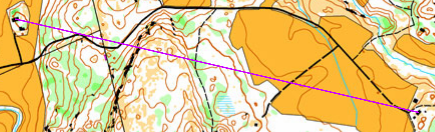
Please correct me if you think that I'm wrong. I've inquired with WOC 2016.
The purple line below is one kilometer.
Please correct me if you think that I'm wrong. I've inquired with WOC 2016.
May 25, 2016 5:36 AM
#
Here is geo-refenced/positioned on google imagery with measure tool. Easy way to quickly sketch some legs/courses.
Even it it is states so I wasn't involved in processing these WOC maps at all. I just may have helped Joakim with other similar projects a little (for lack of documentation).
Even it it is states so I wasn't involved in processing these WOC maps at all. I just may have helped Joakim with other similar projects a little (for lack of documentation).
May 25, 2016 9:47 AM
#
rm:
Thanks Jagge.
On another topic, I'll suggest including a climb number on your control descriptions, as climb was a key topic of discussion in the previous course design non competition, and some submitted courses did not include it, perhaps not tallying it. Climb can be an important consideration when deciding whether a course is the right length, and percent climb gives an idea of the character of the course...how rugged versus fast.
On another topic, I'll suggest including a climb number on your control descriptions, as climb was a key topic of discussion in the previous course design non competition, and some submitted courses did not include it, perhaps not tallying it. Climb can be an important consideration when deciding whether a course is the right length, and percent climb gives an idea of the character of the course...how rugged versus fast.
May 30, 2016 11:51 PM
#
rm:
Thanks to Comfortable Pedestrian and Silver Trot for their submissions. Lots of thought into terrain use, spectators and TV.
As a reminder, you have another month (or so) to submit a course, but I'll start posting submitted courses in about two weeks, in order to give lots of time for review, and still finish this non competition before the World Championships.
As a reminder, you have another month (or so) to submit a course, but I'll start posting submitted courses in about two weeks, in order to give lots of time for review, and still finish this non competition before the World Championships.
Jun 7, 2016 12:33 AM
#
rm:
Thanks to Frequent Cat for a third submission. I'm glad that so many people have taken the spectators and media to heart. I'll start posting the submissions in about a week and a half, but feel free to submit through at least the end of June.
Jun 12, 2016 11:39 AM
#
rm:
I'll start posting submissions about Wednesday, one every three days or so, with a pause for the Laramie event. Four submissions currently. You can submit a course anytime this month, or even a little after.
Jun 16, 2016 12:52 PM
#
Cool initiative! It might be good to know that there is a new highway (partly on a bridge and in a tunnel) cutting through the area: http://kart.gulesider.no/m/iH2UQ
Jun 16, 2016 1:48 PM
#
I think we knew it already, since it is clearly visible, just open the link I posted above and use the opacity slider at top right to see the new road compared to the O map.
Jun 27, 2016 5:22 PM
#
rm:
Just a quick seeking of opinion before the last submission (so far) is posted Tuesday morning and I head off to the Laramie event.
How well has this installation of the course design non competition worked out? Is the length of time for submissions good? The pacing of the posting of submissions? The use of image rather than PDF? The value of the discussions? Any takeaways?
Unless people are keen for another non competition in August/September, or someone else runs it, the next non competition will probably be in January, probably a sprint or a forest relay.
Jun 27, 2016 6:17 PM
#
AZ:
(I vote for ski O in January - to promote the sport and get more people giving it a go)
As for the others - I'm happy with how this one went. Hope it was helpful for the WOC athletes too, and that it stirred up some additional interest in the upcoming WOC, which I think will be pretty special one
As for the others - I'm happy with how this one went. Hope it was helpful for the WOC athletes too, and that it stirred up some additional interest in the upcoming WOC, which I think will be pretty special one
Jun 27, 2016 6:49 PM
#
rm:
Hmm....how about I do a quick sprint non competition in August and September for anyone interested, and then someone with more knowledge than I organizes a ski o non competition in October and November (Adrian? Mary Jo or Carl? Terje?). This would spur interest before the season. In the meantime, I'll post the challenge in July for the forest relay, which will take more time for people to set, with a submission deadline sometime in January. It could be an elite relay, or a middle age relay, or a junior relay, or even an intermediate difficulty relay. But, given the recent fun following Jukola, and the opportunity that the following would provide to set both day and night navigation, as well as different lengths and difficulties, I'm considering a several leg relay (not exactly Jukola, but inspired in some aspects) that spans several lengths and difficulties, starts in late afternoon and runs into the night. Perhaps a very crazy idea, or maybe a fun challenge that spans many aspects of course design.
Jun 27, 2016 10:21 PM
#
For ski-O, one interesting aspect will be to how much of an extent the entrants are allowed to add twisty snowmobile trails.
Jun 27, 2016 10:36 PM
#
rm:
Maybe I'll offer the local state park map, to save myself course setting for it for this winter. ;-) 20 Sq km with lots of trails, perhaps not even needing extra tracks. Not ISOM though. (Topics like extra tracks are why I'd defer to someone else organizing the ski o non competition. )
Jun 27, 2016 11:17 PM
#
Jun 28, 2016 1:20 AM
#
rm:
I loved 25-manna! It may be too many legs for many people to set though, just for a course design non-competition. :-) Similarly the 20 for Tjoget. But if enough are keen...
Jun 28, 2016 8:16 AM
#
@JimBaker: Re your suggestion on doing a relay:
Way back when, May 1st 1974, I joined forces with my younger brother Knut and our great pal Pål as the course planners for the very first forked relay in Norway. At the time we designed the courses we were 16, 15 and 14 years old! :-)
A few months ago Morten Skoglund posted his race map so we all got to see what kind of courses we had created:
http://byasenorientering.com/kartarkiv/show_map.ph...
Notice the 8 controls for an 8+ km course...
We had forking for the first two legs, then the third leg went the opposite way through the terrain with no forking.
Together with Knut I've managed to figure out/remember where those extra forking controls were located, i.e. for the first control the alternative was on the SSW of the two two-line marshes NE of the shown control, many runners stuck with the left-hand group all the way up to the control.
#2 & 3 were common then we had another forked control for #4 about 100 m distant, a common #5 and the final forking was on #6 where we used the cliff to the NW. This was sufficient forking to totally get rid of the up to then standard long queues on every relay.
Jun 28, 2016 12:37 PM
#
rm:
That brings back memories of readable maps from my early days of orienteering. Simple can be good on relay forking. Maybe I should leave open the choice of what format of relay to design...3 legs, 25 legs, same difficulty legs or different.
Jun 28, 2016 1:03 PM
#
Jukola would be interesting. There is some crucial things to get right most may not be aware of. For example first controls of the first leg, there is ~1700 runners so there should be room for them but first forking should be very equal - if firs controls are not far enough and one forking is slower it means they may fall behind hundreds of slower runners and will loose plenty of time more for having pass them. A faster forking later on will not make it equal. Also, second half of the second leg usually shouldn't be paired with the first leg, because leading teams of leg 2 would hit a dense wall of hundreds of walkers already one round behind. And so on.
Jun 28, 2016 6:18 PM
#
rm:
OK, after some thought and people's comments above, I think I'll start a forest relay course design non-competition next week or so, with a submission deadline of mid January 2017. I'll suggest a set of leg lengths and difficulties along the broad lines of Jukola, 25-manna or Tjoget, but not insist on them; if people prefer to set a different format of forest relay (three F17-18 legs of the same length, or whatever), that's fine. (By leg in this context, I mean leg of the relay, not leg of the course.) The discussion of what makes a good relay will still be interesting. I've requested permission for map use. I'll post instructions on what images to submit for the designed course, such as an image of overall forking with all legs, and an image of each leg with all forks, with a recommended notation scheme for forks to help the discussion.
I'll delay the Sprint course design non-competition until late March through early May 2017, just before some northern hemisphere clubs move their orienteering to the city parks, as the level of interest seems to be for about 3-4 non-competitions a year.
A ski-O course design non-competition may be organized if someone expresses interest in organizing it, perhaps in October/November before the main northern hemisphere ski season, or whenever the organizer cares to.
I'll post any further submissions that I receive for the Middle M21 non-competition on the WOC 2016 autogenerated Tanum map, at least up through WOC. All submissions received to date have been posted.
Jun 28, 2016 6:20 PM
#
rm:
Actually, if you have a Long F21 course that you designed on the Otter Creek map but never submitted, I'm happy to post that too.
Jun 29, 2016 6:32 PM
#
This is not an entry to this non-competition, but I posted this here anyway. For fun I tried to make a quick course sketch matching bulletin climb, length and control count stats with new road taken into account and with picturesque start location for TV.

Might give some idea what it will possibly be about like. I wonder will they close the motorway (traffic would use the old road) and put there cranes with TV cameras and shoot with them the slope, controls placed close enough to the road to be visible.
Might give some idea what it will possibly be about like. I wonder will they close the motorway (traffic would use the old road) and put there cranes with TV cameras and shoot with them the slope, controls placed close enough to the road to be visible.
Jun 30, 2016 9:22 AM
#
@Jagge: I did look at the possibility to cross the E6, I think your 17-18 underpass is OK but I'm afraid that the path to the start might be blocked unless they did put in an underpass for the path when they made the new road.
I really don't think they will manage to close the highway, but if they do it would make for far less traffic noise in the Event area. I do think your final loop is quite possible, it is the most obvious way to achieve the stated total climb figures which are 10-20% higher than what you get from setting a normal course without arena pass through.
I really don't think they will manage to close the highway, but if they do it would make for far less traffic noise in the Event area. I do think your final loop is quite possible, it is the most obvious way to achieve the stated total climb figures which are 10-20% higher than what you get from setting a normal course without arena pass through.
Jun 30, 2016 9:33 AM
#
@Terje,
If you look closely on Google maps there is an underpass where the path is on the way to Jagge's start:
https://www.google.ca/maps/@58.6925539,11.4002849,...
If you look closely on Google maps there is an underpass where the path is on the way to Jagge's start:
https://www.google.ca/maps/@58.6925539,11.4002849,...
Jun 30, 2016 10:30 AM
#
@Terje yeah, I could not get correct climb figures without hitting biggest hills several times on purpose just to get more climb. The only explanation I could think of is spectator leg and such second loop. This also means the east of the road part of the course will not be that long. They will have to make most out of it, and that part must be quite hilly too to get that 320m climb figure. No much room for transfer legs on flat hilltops. So I believe the first part of the course will zig-zag this rugged area near the road, one way or an other. Plus such final loop.
Jul 1, 2016 5:27 AM
#
@Jagge: The more I look at the map with E6 addition, the more I'm thinking that your suggested route has to be pretty close to the real deal!
There are only a couple of alternatives that also hit the length/climb specifications, and they both seem to require an arena passthrough and a final loop in the steep hill to the east:
a) The same as your suggestion, but moving the start to the north so that both the big overpass and the underpass are available for courses.
b) Starting with (a) and then end the first part on the west side of the arena, passing over the tunnel, then an arena passage from west to east, and a final loop to the east which can then be longer since it can use both the big over and the small under pass.
Aug 23, 2016 2:39 PM
#
OK, so now we have the facit: The real H21 course turned out to be a mix of Jagge's and my ideas: The start was on the far side of the highway underpass, as per Jagge, then they passed around the arena and over the highway tunnel as I suggested, but then they had the final loop on the west side, something that should have been impossible while achieving the stated climb!
The latter fact have lead me to suspect that they have used a small cell size Digital Elevation Model (1x1m or 2x2m DEM) to measure the climb instead of the usual counting the number of crossed contours.
The latter fact have lead me to suspect that they have used a small cell size Digital Elevation Model (1x1m or 2x2m DEM) to measure the climb instead of the usual counting the number of crossed contours.
Aug 24, 2016 12:28 PM
#
The climb clearly isn't calculated the way it is used to calculate. By counting contours I got max 210m. So 80 meters is missing compared to the advertised climb. They must have done it the way Terje suspects and sucked plenty of tiny up and down meters in their figures.
I did quick WOC map - auto generated comparison animation.
http://routegadget.net/misc/WOC2016middleautogener...
I did quick WOC map - auto generated comparison animation.
http://routegadget.net/misc/WOC2016middleautogener...
Aug 24, 2016 12:42 PM
#
It's amazing how accurate the auto-generated maps can be, picking out small crags.
Aug 24, 2016 2:10 PM
#
rm:
Cliffs and vegetation do seem very similar, contours slightly different in spots. If auto gen can be this close to a WOC map, maybe I should be using it more for trainings.
Aug 24, 2016 5:19 PM
#
If auto gen really is so close to a WOC map I wonder how much time and $s were spent to make it into an actual WOC map? I guess a lot.
Aug 24, 2016 7:26 PM
#
I look at the same pair of maps and have the opposite thought. The autogens are clearly worthwhile for training, when a real O map doesn't exist, I have actually spent time on one of these maps in Sterling Forest NY/NJ. They are great for terrain exploration. However as a base map, I'm not impressedl, no offense intended..
The contours are surprisingly different, given they are both lidar based, and seem to have the same base levels. The green is especially weak, providing nothing in the way of precise detail (lines and points), which is what the mapper needs.
On the positive side ,the yellow details in the open forest actually look rather good. And yes these maps pick out cliffs better than traditional O bases, but not better than sharp lidar contours, at small intervals of 1.0m or less.
Aug 24, 2016 8:25 PM
#
It may be worth noting the density of Sterling Forest NY/NJ lidar was only about half of what is should be in minimum. For example, if there is 3 m between points on average you really can't map smaller than 3 m cliffs (if we expect at least 45 degrees slope). Same issue makes it hard to get vegetarion boundaries and soesn't help much with contours either, a lot can fall between points and stay unseen. If point density is three times better chances are a lot better to get something usable out of it.
But EricW got it right, it is not that good base map and not even intendedto be one. It is supposed to be something one can read at 1:15 000 scale at running speed, thats why default contour interval is 5m and everything is generalizes, rounded and smoothed. Yelloe isn't generalized enough, but pale tone doesn't clutter much.
For those interested in base map making, for base maps we use partyally same approach and app but differently, examle here: https://www.facebook.com/media/set/?set=oa.8921827...
usually 0.625 m contours and several different type of vegetation images to make it possible to see boundaries accurately. But thats not something one should start training and running with. Anyway, Terje has more experienced on base map making, I suggest studying those scripts he has shared.
Aug 25, 2016 7:36 PM
#
As Jagge writes I have spent pretty much all my development time trying to create the best possible base maps, i.e. including everything that the mapper could need in order to create championship quality maps with the least amount of effort.
My standard setup generates 1m contours with zero smoothing but I have considered also generating an alternate set with slope-dependent smoothing of the ground points since this is much more likely to be directly usable at least in parts of the map.
I'm holding a presentation tomorrow evening at the IOF about my vegetation process, this is basically similar to the Netflix problem:
I.e. given a set of samples (all ground and vegetation hits in a given spot/small area) find the best match to these samples in a base map calibration set.
I start with a default set, then after the first survey rounds I get local benchmark plots back from the mappers and redo the entire process, using these local calibration samples as the targets to match.
It was an interesting problem how to convert these vegetation pixels back into proper OCAD vector/area objects. :-)
Re. Jagge's comment about LiDAR densities: The more the merrier! I like to have at least two pulses per square meter but even the minimum used in Norway (0.5 pulses/sq m) gives pretty good contours but less well defined vegetation plots.
This discussion thread is closed.