Discussion: Clue sheet Column C
in: Orienteering; General
Sep 14, 2017 3:32 PM
#
Crowdsourcing this one:
is this correct? there is only one staircase, but there are two bends inside the circle. Does Column C apply when there are two staircases, or can it be used also when there are two bends in the same staircase ?
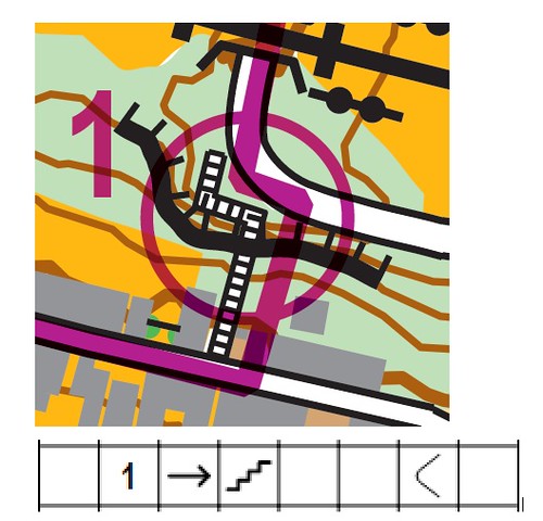
is this correct? there is only one staircase, but there are two bends inside the circle. Does Column C apply when there are two staircases, or can it be used also when there are two bends in the same staircase ?
Sep 14, 2017 3:48 PM
#
Fix your map to meet standards, and then worry about exact control descriptions. If your map has so many issues, don't try and use control locations that are even the slightest bit unclear.
Sep 14, 2017 3:51 PM
#
I think your clue is correct. My interpretation would be that the clue describes a single feature: a staircase bend. Since there are two staircase bends within the circle, you should use Column C to define which staircase bend...i.e. the East one.
If there were multiple staircases with multiple bends within the circle, I'd suggest that you hang your control on one of the bends that could be described properly by Column C...namely the East one, the West one, the Middle one, etc. Obviously Clue Sheet nomenclature makes it difficult to select any of a dozen similar features within the circle. For example, AFAIK there is no way to designate 'Third staircase bend from the east.' :-)
If there were multiple staircases with multiple bends within the circle, I'd suggest that you hang your control on one of the bends that could be described properly by Column C...namely the East one, the West one, the Middle one, etc. Obviously Clue Sheet nomenclature makes it difficult to select any of a dozen similar features within the circle. For example, AFAIK there is no way to designate 'Third staircase bend from the east.' :-)
Sep 14, 2017 3:53 PM
#
rm:
The map shows the staircase blocked by an uncrossable cliff. Is that correct? Or should the cliff be gapped?
Sep 14, 2017 3:55 PM
#
The staircase is built to allow pedestrians walk from below to above the cliff
Sep 14, 2017 4:03 PM
#
rm:
Looking at the specification, bend is wrong, and should be used where there's a smooth change in direction. Corner should be used where a linear features turns a corner. So, inside or outside northeast corner, which then clearly doesn't apply to the other change in direction of the staircase.
Sep 14, 2017 4:06 PM
#
AZ:
I think I have to disagree with chitownclark. I'd like it to be that way, at least in situations like this. But from the old IOF docs...
Column C - which of any similar feature
Column D - control feature (i.e. staircase)
Column G - location of the flag (i.e. the bend)
So, C&D go together.
Or, something like f2( f1(C,D), G) ;-)
Column C - which of any similar feature
Column D - control feature (i.e. staircase)
Column G - location of the flag (i.e. the bend)
So, C&D go together.
Or, something like f2( f1(C,D), G) ;-)
Sep 14, 2017 4:06 PM
#
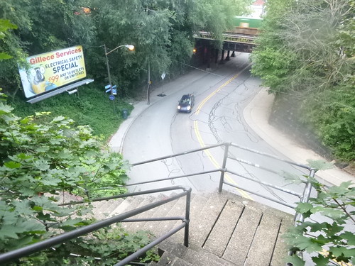
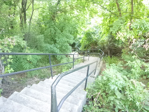
https://www.google.fi/maps/@40.4248802,-79.9809028...
https://www.google.fi/maps/@40.4251395,-79.9808908...
Stairs or bridge?
Outside or inside corner might give impression it is down on the ground and not high up there.
I'd say the original description by sherpes is easily good enough. It is not misleading, no-one will get wrong impression by it. But map sure gives wrong impression. But any map is better than no map at all and pretty much any event is better than no event at all, so better not worry too much...
Sep 14, 2017 6:07 PM
#
I kinda favor bend just because it implies "on the stairs" to me.
If you use NE-corner, either inside or outside, you need column C to show which of the two bends you mean. If it's on the stairs, you could do:
Northeastern stair NE-corner-inside, or
Southwestern stair NE-corner-outside
Which I find confusing.
If being off the stairs is possible, I'd consider ignoring the fact that there are two corners, and just use stairs-on top with the circle exactly as shown.
This is a place I might try to use the control circle with focus point, if the software allows that.
Sep 14, 2017 6:13 PM
#
You mention column A -- isn't this column C you're actually talking about?
Sep 14, 2017 6:15 PM
#
Placing the control at the bottom or top of the stairs would eliminate any of these issues altogether... if it's not crucial to overall course design, probably what I would do, as opposed to in the middle, in a bend.
What is the scale of the map? 1:10,000? Or is this a sprint map at 1:5,000?
The options at the south side of the stairs are limited with the out of bounds - not sure how that plays out with the next control?
What is the scale of the map? 1:10,000? Or is this a sprint map at 1:5,000?
The options at the south side of the stairs are limited with the out of bounds - not sure how that plays out with the next control?
Sep 14, 2017 6:25 PM
#
Jim Baker, you are saying that the first one here below should be "corner" and the second one below that should be "bend" ?
Sep 14, 2017 6:33 PM
#
Sep 14, 2017 7:21 PM
#
rm:
I'm just reading from the spec. (My previous post lifts some text verbatim.). Personally, I'm ok with either way, but the spec is quite explicit, so for championships one should probably use the corner symbol for corners, and bend for smooth bend.
I'm not sure how northeast corner could apply to the left corner? But it shows how people understand things differently.
I haven't reread the spec enough to find out whether it explicitly links columns C and D. I've always been a bit unclear on that, and should check carefully. But clearly not everyone has the same understanding of it. Probably worth writing more explicitly in the next spec. Stream bends are one feature in which "northern bend" can be quite useful.
Sep 14, 2017 7:31 PM
#
Well AZ, and Jim, my rule is that the clue should always define a single, non-ambiguous Point. And by AZ's interpretation, the Col C 'Eastern' is meaningless, since there is only one staircase.
So I think AZ's interpretation is wrong. For instance, go to BOK's page and download the IOF Specifications for Control Descriptions, turn to p. 21 and observe the following examples:
#50 "Southern Stream Bend" showing single stream, three bends
#54 "Northern Ditch Bend" showing single ditch, multiple bends (definitely 'corners')
IOF even provides map thumbnails and pictures. These seem to support my contention that the 'which feature' selector in Col C INCLUDES the 'where on the feature' designation in Col G. Thus I stand by my original contention; sherpes' clue is correct as stated.
Sep 14, 2017 7:31 PM
#
rm:
By the way, is "staircase cliff crossing" a viable description? (I like quirky, unique descriptions, but not everyone does. Nonetheless, it seems reasonably clear and sufficiently specific. If people are worried about controls being hung under the staircase, then maybe the description doesn't suffice.)
Sep 14, 2017 7:40 PM
#
bmay:
What would happen if we didn't have column C? Would we be forced to read the map more carefully, to determine, on our own, without the course setter telling us using complicated control-description hieroglyphics, that the control is on the eastern of the two staircase bends? With modern course-printing (i.e., control circle accurately centred on the feature of interest), it strikes me that we could eliminate column A entirely. If you want to know which of multiple features the control is on ... read the map.
(Edited to reference column C.)
(Edited to reference column C.)
Sep 14, 2017 8:28 PM
#
rm:
I had thought of them more like petroglyphs (Kokopelli would be a great feature description in the desert Southwest of America...a few locations in New Mexico seem to have lots of rock art), but hieroglyph works too. I think bmay means column C? But if not clarifying which of many similar, why clarify which of many dissimilar? Why clarify knoll vs boulder? At 1:7500, you'll be pretty close by being within a millimeter of the center of the circle (i.e., within 7.5m, or two car lengths). At 1:3750 someday it'll be even closer.
Sep 14, 2017 11:50 PM
#
What is your "this" JJ?
Crappy maps?
Shitty control placement needing bad control descriptions?
Inane discussion about it on AP started by Sherpes?
Make good maps with clear drafting, then make good course with challenging but clear control locations.
If you need to reference the control description spec to prove that your control was in the correct place, then it was probably a crappy place to begin with. The point isn't to trick people, but to give them a navigational challenge getting to the control.
Sep 15, 2017 1:08 AM
#
rm:
To be honest, I think that the control location is fine and clear, and the description OK. (The specs clearly indicate that corner should be used, but bend is clear, as is eastern.) It doesn't appear that hard to figure out at competition speed where the flag will be. I prefer simple descriptions, but as chitownclark points out, IOF gives examples of "southern stream bend" and "northern ditch bend" in the spec, so while I like simplicity, "eastern feature bend" is something that competitors should be able to handle.
The map could be significantly improved by breaking the cliff where the staircase crosses it, and removing the cliff tags near the staircase for legibility (minimum object separation et al). The use of what appears to be light grey for buildings is also confusing; should be dark grey or black. Light grey is for things that can be passed through on course, like a picnic shelter or breezeway. These are matters where the map doesn't appear to be to spec, significantly. (Clearly from Google Street Maps, which has images following the staircase, it crosses the impassible cliff, but the map shows otherwise. The minimum object separations appear not to be met, and the apparently uncrossable buildings appear to be shown as breezeways.)
I don't agree with all elements of all IOF specs, but I think that we could do well by following them a bit more. At least we'd have readable maps, which seems to my naive thinking to be relevant to a navigational sport. Personally, I'd rather see steps taken in this direction, rather than, say, limiting descriptions to two columns.
Sep 15, 2017 2:48 AM
#
AZ:
Well, Chitownclark, you are showing that the examples agree with you, but the actual letter of the laws don't. Still, I'd say common sense agrees with you ;-)
In any case, in the upcoming update to the control descriptions, this issue is addressed since "Bend" is moved from column G to column F. So now it is part of the feature's description (i.e. a stream bend is now an actual feature).
In any case, in the upcoming update to the control descriptions, this issue is addressed since "Bend" is moved from column G to column F. So now it is part of the feature's description (i.e. a stream bend is now an actual feature).
Sep 15, 2017 9:39 AM
#
bubo:
Does it really matter (in this case)? You have to use the stairs either way - from the top or bottom - to reach the control and there can´t be more than a few meters between the points that are visible from each other...
In other cases I agree with Ed.
In other cases I agree with Ed.
Sep 15, 2017 1:27 PM
#
@JimBaker, thanks for the info and suggestions (see below).
As for the buildings being black, that was our original design years ago but once printed, it looked too "loud" and after a few other samples using different lighter tones, we opted for the current choice. The visual focus and interest is on the steps and walkways, and not the buildings After all, this is a self-guided tour in a thick urban setting by a local neighborhood association, not an official orienteering meet, where participation is 500+ people, walkers, most of them aged 40-65, slow pace, in a festive style (musicians on the route, food trucks, history lessons, storytelling). The O club participation in offering this map to participants is publicize the activity and sport of Orienteering, and hopefully we will get some additional attendance in future meets, in a cross-pollination effort. BTW: even with 500+ participants, we are only going to print about 60 maps. From past years's experience, the majority of the participants flat-out refuse any solicitation or flier handed to them, and even those that stop to learn what it is about, some will still refuse the offer, as it is too "brainy", and all they care for is their step count and their fitness wearable gadget. (ironically, a few that, AFTER they walked their route, did stop at the O table to ask about "what were those flags we saw on the route", and learned about the map and O activity, they expressed interest and regret that they didn't know about it - and these were the folks that on-principle rejected any solicitation).
It would be nice to eventually use this urban fabric for an orienteering running race, as it offers some very interesting terrain and setting with numerous route choices. If we do, we must assure ourselves of a strong participation to justify the high cost of permitting that the city imposes. Other organizations that were based with a more youthful demographics, had a similar map-based running event, which used phone SMS (texting) to prove that a checkpoint was found, and cancelled after two events due to a low count of registered participants.
Not easy to attract people to O events. So, what to do? put beer stops on the course? dollar bills taped to the control flag in a mass-start Score course? place puzzles to be solved that reveals where is the next checkpoint, so to slow down the fast pack and give a chance to the slower ones? All ideas are good, and it may lead to something that is not a classic O event. ... and yeah, changing the building color from black to light gray is one small variation. (Beer on trail is next..)
Sep 15, 2017 1:39 PM
#
Why does this keep happening?
I, for one, appreciate the insightful responses to these types of questions.
I, for one, appreciate the insightful responses to these types of questions.
Sep 15, 2017 1:46 PM
#
Since this is for non-orienteers, FFS why use symbols instead of plain English for control descriptions?
Sep 15, 2017 2:06 PM
#
why use symbols instead of plain English
sometimes hieroglyphics attract interest, as is into some arcane ancient priesthood ritual.
sometimes hieroglyphics attract interest, as is into some arcane ancient priesthood ritual.
Sep 15, 2017 11:46 PM
#
Yes, the purple line is the walker's route. Every year there is a different route offered.
Sep 16, 2017 3:20 AM
#
I had initially wondered why there was an impassable boundary along that particular section until you explained the activity and I figured it out.
Sep 16, 2017 9:24 AM
#
But with English you could have used 'Top of 2nd flight of stairs'. And saved a deal of time with not having to explain the 'hieroglyphics' to every participant.
Sep 16, 2017 11:53 PM
#
Considering the audience and the format, I think you could also just say "stairs".
Sep 17, 2017 1:51 AM
#
Sherpes, thanks for going above and beyond to promote orienteering! Keep it up! ON ON!
This discussion thread is closed.