Discussion: Printing
in: blairtrewin; blairtrewin > 2020-07-04
Jul 5, 2020 11:50 PM
#
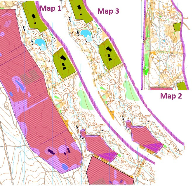
The area was mapped at 1:5,000 according to the old sprint standard. Ever since the first use which was printed at 1:5,000 with two map changes, following course setters have chosen to print at 1:7,500 to avoid map changes. Legibility suffers.
Jul 6, 2020 12:30 AM
#
What I'd do is something like this all on the one page (could even orientate it not to north so it takes up even less space)
Jul 6, 2020 3:11 AM
#
Ahh sorry, should be fixed now but if not: https://photos.app.goo.gl/wMidg5nRSCoFriNk8
Jul 6, 2020 9:46 PM
#
Yes. I have thought about creating a Condes template for a layout like that. Perhaps the blander terrain section might be a problem for course setters who wish to avoid a walk o the start.
Jul 7, 2020 12:28 AM
#
I hope this works. It is an insert using Condes https://photos.google.com/photo/AF1QipOMoO3mbitV8Z...
This is an event that was going to be at Mt Tarrengower this year but was cancelled, so I hid the controls, as we hope to reschedule it sometime
This is an event that was going to be at Mt Tarrengower this year but was cancelled, so I hid the controls, as we hope to reschedule it sometime
Jul 7, 2020 2:14 AM
#
Jim, that's a nope,
404. That’s an error.
The requested URL was not found on this server. That’s all we know.
404. That’s an error.
The requested URL was not found on this server. That’s all we know.
Jul 7, 2020 6:35 AM
#
Yes, lol, but you might as well have left the control circles in. All we have to do is join the straight lines to see where the centre of the circle is!
This discussion thread is closed.