Discussion: Quabbin -- Dugmar golf course
in: PG
Feb 8, 2021 12:10 AM
#
Hey do you know anything about Dugmar? (In case you don't: it was a golf course built in the late 1920s/early 1930s, when Quabbin Reservoir was already proposed, and of course it disappeared with the flooding of the valley. Seems like it may have been a way for the developers to make some taxpayer $, as they were handsomely paid off, after a protracted legal fight, for the loss of their property.) The stone remains of the clubhouse still remain on Curtis Hill, while the course itself is underwater. It was nominally in Greenwich.
I'm working on a blog post about it, so I'm looking for any sources I can ... given your location and golf knowledge, I thought you might know something I haven't found yet. Maybe?
I have been unable to find an exact location (though I found a picture taken from the 9th hole and a google map location of that), or a golf course map, which would be really cool but may not even exist.
Feb 8, 2021 2:42 AM
#
PG:
First off, never heard of it.
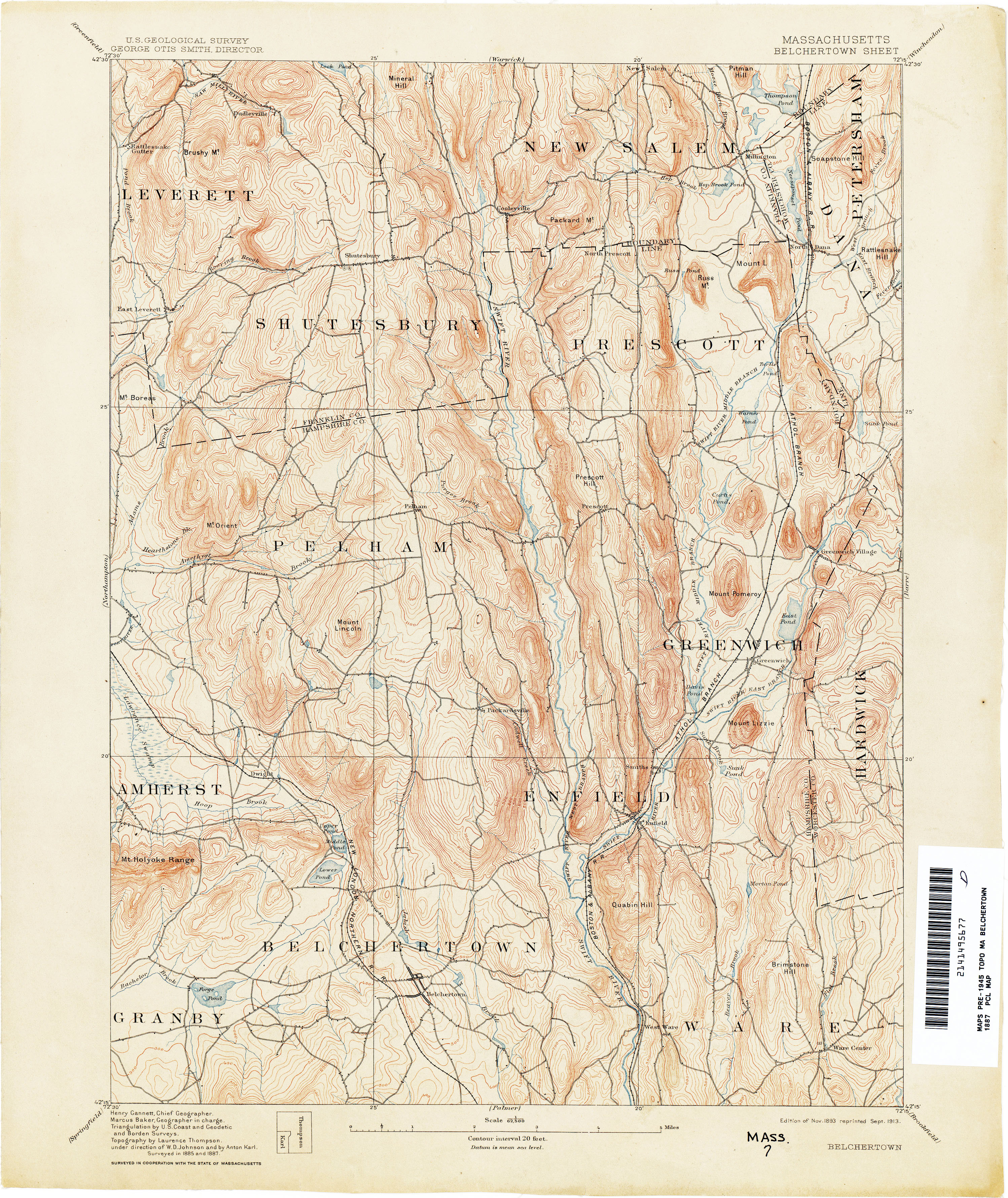
I looked at what I assume is the primary source for you. I can find Curtis Pond on an old topo. I assume Curtis Hill is on the pond's SE side. The photo of the course from the article looks like it is facing SSE over the course. The photo later in the article looks like it is taken just a little bit right of south, with Mt. Pomeroy in the distance (has the right profile). It also says the the clubhouse remains would be visible from the shore down by the intake, and that would fit.
What I'd suggest is contacting John R Greene (mentioned in the article). Lives in Athol (Bearsden Drive, I think), has written a number of books about Quabbin, still gives talks. Can't imagine he wouldn't be happy to talk.
Interesting stuff in here. But I'm sure you've already looked around a bunch.
Feb 8, 2021 3:58 AM
#
Super interesting article. I love this stuff. Never really thought about how the people's lives were wrecked by the project, given a pittance of money, and no home and maybe no job..... I would so love to be able to explore those islands.
Feb 8, 2021 10:02 PM
#
Thanks Peter! But, yes, I have seen all those sources. I try to do a pretty thorough search before I write my blog posts, because I'm afraid I'll get something wrong and someone will yell at me. Almost everyone is really nice though.
And I'm glad at least two of you think it's an interesting story (maybe not specifically the golf course), because then probably others will as well.
I found out about the golf course while researching the area of my ancestors, and while I've long wanted to blog about the area, I didn't have a good angle. The golf course is pretty interesting though! My ancestors, btw, were gone from Swift Valley (they were in Greenwich; I was intrigued to find out is pronounced "Green-witch"! ) about a century before the reservoir was a thing. (Remember I was asking about the graves; I still haven't found my 6th great-grandmother, who supposedly died in Greenwich ... or my 5th g-gmother and -gfather, for that matter.)
Feb 11, 2021 2:08 AM
#
Of the four towns that got flooded out, only Enfield is pronounced the way you might expect. Prescott was Presskit, and Dana was Daner.
Feb 11, 2021 10:53 AM
#
The fourth is Greenwich. (Which non-New Englanders would probably—correctly—pronounce green-witch). Would never have guessed “Daner” or “preskit “!
Feb 11, 2021 9:54 PM
#
As an almost New Englander for 40 years (15 miles into NY doesn't count), I would have guessed green-witch and press-kit, but not daner, necessarily.
Feb 12, 2021 12:09 AM
#
For anyone who likes podcasts and such, there's a radio documentary about the former towns of the Quabbin. (Mostly good, a little bit of a weird attitude at times.)
The pronunciation of Dana is context-sensitive, the same as Kennedy pronouncing Cuba as Cuber. It only happens when followed by a word with an initial vowel sound.
The pronunciation of Dana is context-sensitive, the same as Kennedy pronouncing Cuba as Cuber. It only happens when followed by a word with an initial vowel sound.
Feb 12, 2021 12:43 AM
#
Nice! I look forward to listening to this.
I am currently obsessed with Quabbin and the four “decommissioned “ towns.
I am currently obsessed with Quabbin and the four “decommissioned “ towns.
Feb 12, 2021 4:17 AM
#
Next time you're up this way, maybe you can take the time to pay a visit to Dana. It's the only one of the four towns that remained mostly above water, and it's a pleasant bike ride (or run) from the gate to the old town site. Not that much left to see, of course, and depending on the time of year, you might need to take precautions against FDFs.
Feb 16, 2021 3:33 PM
#
I'd love to visit Dana. It's a NPS site :-). My family members are much less interested in this stuff than I am, so a visit would have to be fun for them ... like a nice hike/run/bike combo (Sam wouldn't love that, but she likes ghost towns so maybe the old foundations would interest her).
You can now check out my new
blog post about Dugmar.
You can now check out my new
blog post about Dugmar.
Feb 16, 2021 3:59 PM
#
There are remnants of a crashed airplane out there if you know where to look. (Maybe more than one? Or else the reports are inconsistent.)
Feb 19, 2021 12:39 AM
#
I recall a run to the site of a F-106 crash in the early '70s on the west side of Quabbin. Plane was gone, but the trees had been smoothly shaved at an angle as the plane sliced down to the ground.
Feb 20, 2021 11:44 PM
#
Thanks Ken! It's really a mirror site of my blog at work, where I've been writing for 8+ years and have 500+ posts. I'm slowly adding some of my favorites to my Wordpress site, but it's a lot of work. (Not all the posts are as long/research heavy. Some are very simple.)
This discussion thread is closed.