Discussion: The Australian 99
in: Orienteering; General
Jan 10, 2010 5:50 AM
#
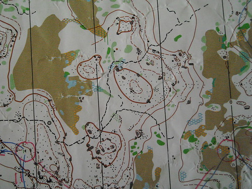
Readers of CompassSport will know that they recently published a list of the best area in each of the UK's 99 traditional counties (with the challenge being to see who has run on the greatest number of them). This naturally prompted me to try to think of a shameless rip-off of this idea which could be adapted to Australia. We don't have enough states to do it properly, and have too many local government areas. As it happens, we do have a division of Australia into exactly 99 areas - the Bureau of Meteorology rainfall districts, which may be seen at:
http://reg.bom.gov.au/climate/cdo/metadata/maps/ra...
(it would be nice if there were a higher resolution map but I can't find any online, although I have better ones in hard copy at work if yuo have a map in mind and want to check out exactly which district it's in).
To start the ball rolling I've done some commentary below. In the main section I've only listed maps I've run on (with comments below on districts where I know there are, or think there may be, maps that I haven't run on). One thing I've done in my selection is to try to represent a good range of terrain types - otherwise it is a bit of a challenge to get classic SE Australian gully-spur in (for example, I chose a gully-spur area for district 70 because ACT granite is represented in districts 69 and 71). Where a district boundary crosses a map I've only counted it once. I also wanted to get an urban sprint map and a classic street-O map in, hence the choices for districts 66 (which has some decent, if thick, bush maps) and 86 (which doesn't).
Not all the maps are in current use, and some no longer have access.
Discussion is absolutely encouraged. Information on maps I don't know about is especially welcomed.
WA
9 - Malmalling
10 - Hill Park Dale
I'm not aware of any WA maps in any other districts, although it's possible there might be some in district 8 (this starts at New Norcia).
NT
14 - Coomalie Creek
I think there are some urban/semi-urban maps in Alice Springs (district 15) - can anyone confirm?
SA
19 - Mannawarra
21 - Twigham
23 - Mount Crawford (I wanted to get a 'classic Adelaide Hills' map in as I think it's the closest equivalent we have in Australia to continental Europe, although Kaiserstuhl is a better area)
24 - Narrinyeri Hills
26 - Cantara Dunes
District 18 has numerous maps in the Port Lincoln and Whyalla areas but I've never run on any. As far as I know there are no maps in districts 16, 17 (which stops about 20km north of Wilpena), 20 (which stops about 20km east of the Burra maps), 22 (unless there is something on Kangaroo Island) or 25.
Queensland
39 - Bettong
40 - Esk Forest
41 - Cascades North
Townsville have maps in district 32, and perhaps 33 depending on how far afield they go. Are there any maps in the Cairns area? (district 31). I don't think there are any maps in any other districts (although the map out near Dalby might go close to district 42 - exactly where is it in relation to Dalby)
NSW
47 - Living Desert
50 - Sappa Bulga (I think the boundary between 50 and 65 runs through the map)
55 - Banalasta
56 - Mount Duval
58 - a map whose name I have forgotten next to the Grafton-Casino road with about 10 features on it that I ran on at a junior squad challenge in 1990 (not many options in this area)
61 - Stockton Dunes/Bob's Farm
62 - Ganguddy
63 - Kahli's Rocks
65 - Gumble
66 - Sydney Olympic Park
67 - Toota Maroota (I think this is the only map in this area I've run on; there's probably better out there. The district comprises the Sydney basin between the Hawkesbury/Nepean and Parramatta)
68 - Wattle Ridge
69 - Badja North
70 - Inverary
71 - Buckenderra
72 - Burngoogee
73 - Gardiners Lookout
74 - The Rock (Wagga is more or less at the intersection of districts 72, 73 and 74)
I do not know of any maps in districts 46, 48, 49, 51 (starts a few km NW of Dubbo), 52, 53, 54, 57 (western boundary runs roughly parallel to the New England Highway and about 30km east of it), 59, 60, 64 or 75.
Victoria
80 - Mount Korong
81 - Kooyoora
82 - Kangaroo Crossing
83 - Pretty Valley (not sure I can really count this as an O-map)
86 - Mount Eagle
87 - Little Forest (chosen ahead of Borhoney Ghurk to get a gully-spur area in)
88 - Mineral Springs and later variations thereof
89 - Nerrina/White Swan (this straddles the 88/89 boundary, I think - if it's all in 88, then 89 becomes Chinamans Flat)
90 - Baileys Rocks
District 85 has a number of 1970s vintage O-maps (although I don't know exactly where) and the Darlimurla MTBO map, and there are some maps in the Mildura area (district 76) - StK66 may want to comment further). I do not know of any maps in districts 77, 78, 79 or 84.
Tasmania
91 - Benbullen
92 - Golden Fleece
94 - Pittwater
95 - Bothwell
96 - the 1998 Tas Champs map near Bronte Park whose name I have forgotten
I'm pretty sure there are maps in district 93 (central midlands between Cressy and south of Oatlands) but I haven't run on them. As far as I know there are no maps in districts 97, 98 and 99.
There have been rogaines in some of the 'missing' districts - definitely 7, 17 and 51/64 (Warrumbungles), and I wouldn't be surprised if the Victorians have been into 79 and 84 as well.
Jan 10, 2010 8:52 AM
#
Blair,
most of the weather forecast districts on the BOM radar pages look like they match up with the rainfall districts
eg Newcastle 256 km so the radar maps may be useful for a first pass.
These maps have got the advantage that you can turn the topography, towns, roads, rivers etc on to get more detail to check the location of a O map, but some forecast districts are subdivided - eg NSW Central Tablelands district covers rainfall districts 62 and 63.
Jan 10, 2010 8:59 AM
#
Two maps in district 76 Blair - 'Cowanna Bend' would be the best of the two - Murray River flood plain terrain.
Jan 10, 2010 9:14 AM
#
WA
9 - Malmalling
10 - Hill Park Dale
I'm not aware of any WA maps in any other districts, although it's possible there might be some in district 8 (this starts at New Norcia).
Not for orienteering - there's plenty of rogaines in WARA's history up that way though.Northern-most map is Keaney College, just north of Bindoon (1/4 of the way to Morawa on your BoM map). I'll defer to O-ing, but it's no map I've ever seen... Other notes:
* Top left corner of 10A is ~95km due east of Perth, which puts it SSE of York. So...
* 9 - Malmalling
* 9A - Hill Park Dale
* 10A - Dryandra
* Nothing in 10, that's the wheat belt and there ain't no hills. :)
It'd be nice to shoehorn Julimar in there as a rare example of WA's spur/gully country, but there's just not enough districts. Not enough rain either, but that's another story.
9 - Malmalling
10 - Hill Park Dale
I'm not aware of any WA maps in any other districts, although it's possible there might be some in district 8 (this starts at New Norcia).
Not for orienteering - there's plenty of rogaines in WARA's history up that way though.
* Top left corner of 10A is ~95km due east of Perth, which puts it SSE of York. So...
* 9 - Malmalling
* 9A - Hill Park Dale
* 10A - Dryandra
* Nothing in 10, that's the wheat belt and there ain't no hills. :)
It'd be nice to shoehorn Julimar in there as a rare example of WA's spur/gully country, but there's just not enough districts. Not enough rain either, but that's another story.
Jan 10, 2010 9:33 AM
#
I'll put my 2c in for for Tas:
96 - the 1998 Tas Champs map near Bronte Park whose name I have forgotten
That'll be Clarence River Marshes
Map
95 - Bothwell
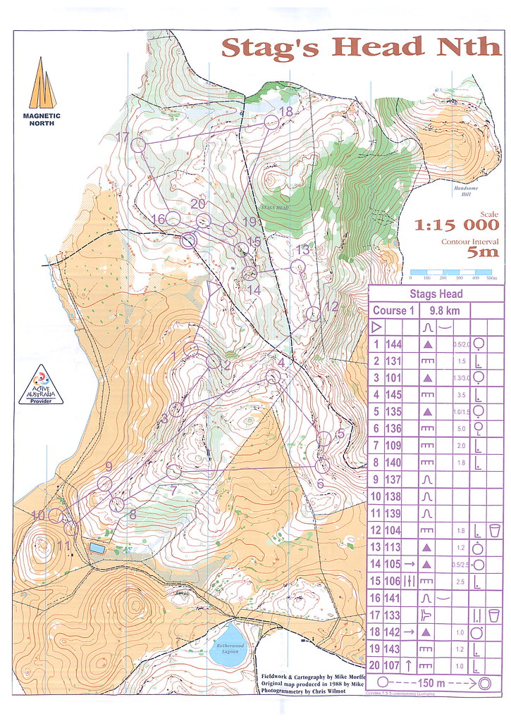
I'd say the best of that area of sandstoney hills is Stag's Head:
Map 2
A lot more features and subtle contour detail compared to the relative blandness of Bothwell. The white forest is usually much nicer than the bracken jungle over most of Bothwell.
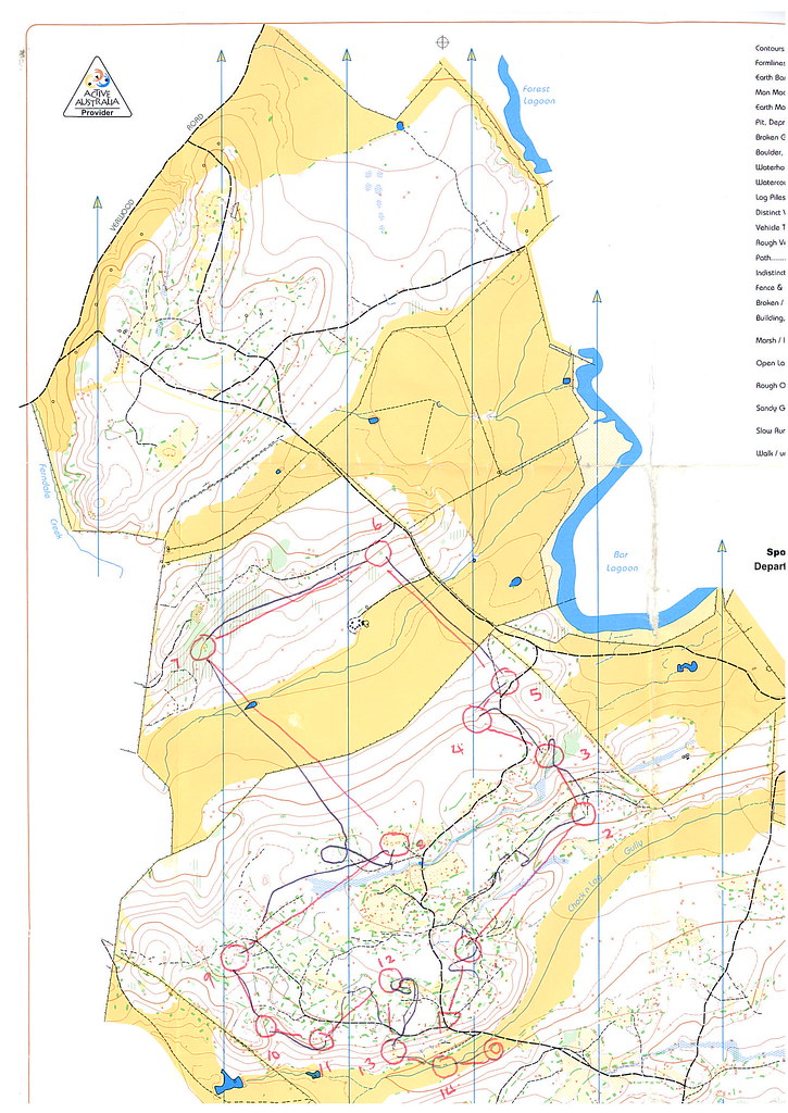
93 - Verwood - I think it may be the only map in there but it's a doozy. Used midweek at the last Easter, gravel mining, probably the fastest white forest in Tassie.
Another map
As for the others
91 - Benbullen - fine by me, though hopefully one day the granitey/mining areas east of Scottsdale will be mapped, then the full trifecta of sand dunes, tin mining and granite will be covered.
92 - Golden Fleece
94 - Pittwater
Anyone trying to argue with either of those two choices is sadly mistaken.
97 may end up with some maps one day, I heard somewhere on the West Coast was being considered for the Easter carnival last year but Launceston won out due to the more reliable climate.
96 - the 1998 Tas Champs map near Bronte Park whose name I have forgotten
That'll be Clarence River Marshes
Map
95 - Bothwell
I'd say the best of that area of sandstoney hills is Stag's Head:
Map 2
A lot more features and subtle contour detail compared to the relative blandness of Bothwell. The white forest is usually much nicer than the bracken jungle over most of Bothwell.
93 - Verwood - I think it may be the only map in there but it's a doozy. Used midweek at the last Easter, gravel mining, probably the fastest white forest in Tassie.
Another map
As for the others
91 - Benbullen - fine by me, though hopefully one day the granitey/mining areas east of Scottsdale will be mapped, then the full trifecta of sand dunes, tin mining and granite will be covered.
92 - Golden Fleece
94 - Pittwater
Anyone trying to argue with either of those two choices is sadly mistaken.
97 may end up with some maps one day, I heard somewhere on the West Coast was being considered for the Easter carnival last year but Launceston won out due to the more reliable climate.
Jan 10, 2010 10:47 AM
#
Juffy, I vaguely remember someone drawing a New Norcia school pseudo-map at some point.... not sure if that counts.
Jan 10, 2010 11:42 AM
#
97.. Henty Dunes one day? Everywhere else is too thick I suspect.
http://images.smh.com.au/2009/06/15/570665/Henty-D...
http://images.smh.com.au/2009/06/15/570665/Henty-D...
Jan 10, 2010 11:45 AM
#
Yeah henty dunes is probably it over there, also maybe the complex erosion gullies of the bare hills of Queenstown too.
Jan 10, 2010 12:20 PM
#
Never found out where, but I imagine it was some kind of combination on dunes/mining.
If it ever happens, there needs to be a finish chute here
http://static.panoramio.com/photos/original/723730...
If it ever happens, there needs to be a finish chute here
http://static.panoramio.com/photos/original/723730...
Jan 10, 2010 1:19 PM
#
There is a map of New Norcia, first drawn by Phil Dufty and updated several times by me. Blair should have remembered Evedon Park, amongst several other maps in 9A, including a couple in Albany and the '06 Aust MTBO Champs around Wellington Dam. In addition to Dryandra (1998 Oz Champs Carnival), 10A also has Kenine Hill from the 88 Oz Champs Carnival. Not sure where the boundary of 9/10 is, but possibilities for 10 include York ('06 Aust Sprint Champs), Umuna, Peterdine, and Julimar (NOL '05). There's also a town map of Northam and school maps at York and Toodyay (Jo and Shep accompanied me to those). I've also mapped the Hyden Primary School and sports ground - Wave Rock would make a good sprint area.Aside from New Norcia, Steve Fletcher has mapped a school in Geraldton, and I've mapped the primary school at Ballidu (where's that I hear you say).
Terry Farrell (Hey U) has certainly done a few training runs in some of the other WA areas, especially 12, but its highly unlikely that the others will ever be used.
Terry Farrell (Hey U) has certainly done a few training runs in some of the other WA areas, especially 12, but its highly unlikely that the others will ever be used.
Jan 10, 2010 10:46 PM
#
Should have mentioned that I treated the 'split' districts (9 and 9A, 10 and 10A, and a few other combinations in the NT and SA) as single districts.
Jan 10, 2010 11:13 PM
#
Question for PatS..
Re the Henty Dunes finish chute... what type of course setter are you? Would you design an uphill or downhill finish?
Re the Henty Dunes finish chute... what type of course setter are you? Would you design an uphill or downhill finish?
 |
| From My Pictures |
Jan 10, 2010 11:48 PM
#
If there are any official O maps on KI, the Uppills would know; some members of OHOC retired there a while back and made maps for their own pleasure but I don't know if there was ever an event held on one.
Of all the Lincoln Orienters & Saltbush (Whyalla) maps in 18, the best terrain is definitely the limestone sinkhole terrain between Pt Lincoln & Coffin Bay. Of these maps, it depends whether you consider Broccoli Hill/The Sandmine as 1 or 2 maps - I'd say Broccoli Hill is the best because of the layered limestone formations. Jennie Bourne described them as "wedding-cake" so maybe that is an official geological term.
Memories of childhood holidays on the family farm at Sleaford, out from Pt Lincoln:
Us kids: "Dad, there's no track there through the mallee scrub!"
Dad: "Well, there was 40 years ago..."
And sure enough, he gets the Landrover through.
Jan 11, 2010 12:07 AM
#
This is for 'best area' rather than 'best map' according to Blair's crtiteria in the first post. So, none of the following areas have been mapped, with the exception of the example for 84, which probably should never have been mapped.
76- Lake Mournpall (sand dune terrain in Victoria!)
78- Wimmera River near Wail (mentioned in Alex tarr survey)
79- Black Range (International standard according to AT)
80- Mount Hope
84- I have sighted a map of a school camp in East Gippsland I think. Not ever going to host an event.
89- A mining area near Staffordshire might give Chinaman's a run for its money. (Likewise good wrap in AT survey)
90- Dreeite (volcanic)
Jan 11, 2010 12:17 AM
#
Black Range - as in 1990 Rocklands rogaine? I must have missed all the good bits then.
Jan 11, 2010 1:16 AM
#
Shep:
blair, is Yackandanda in area 82 or 83? i've seen a sweet looking gold mining map in there, i think it was made by leigh privett. it can't compete with kangaroo crossing but may kick pretty valley off the list.
Jan 11, 2010 1:22 AM
#
Yackandandah's in 82. The area in question is being looked at as a potential area for the 2011 Oceania middle, if it can be mapped adequately at 1:10000.
Jan 11, 2010 1:58 AM
#
I agree: map it at 1:5000. I ran on Leigh's map last year and it is way too complex for 1:10000!
Jan 11, 2010 5:54 AM
#
Is there a formal rule for how to go about breaking the rules? It would be a pity to miss out on Rowdy Flat because of rules.
Re Black Range. Jenny.. not that Black Range. Its on the other side of the Grampians near Stawell. Think Kooyoora. Probably a larger area. Much of it is private land. I'll put a photo link up tonight. You'll see the difference. Its on the VOA agenda...
 |
| From SMB |
 |
| From SMB |
 |
| From SMB |
 |
| From SMB |
Re Black Range. Jenny.. not that Black Range. Its on the other side of the Grampians near Stawell. Think Kooyoora. Probably a larger area. Much of it is private land. I'll put a photo link up tonight. You'll see the difference. Its on the VOA agenda...
Jan 11, 2010 6:06 AM
#
Did someone say Oceania? If it's an international ranking event, have fun getting a scale change approved by the IOF controller. If not, have fun getting it approved by the OA mapping chair.
Ahhh...Black Range as in Bunjil's Shelter with the rock art and the cool granite boulders. That sounds more likely. We were there after Easter 2006, when it had recently been burnt.
Ahhh...Black Range as in Bunjil's Shelter with the rock art and the cool granite boulders. That sounds more likely. We were there after Easter 2006, when it had recently been burnt.
Jan 11, 2010 6:33 AM
#
Shep:
i guess it would be better to run on a worse area so the map can be 1:10000.
Jan 11, 2010 10:48 AM
#
Is there any rule about providing 2 maps for a course?
At the start give each of the 21E runners 2 maps (1:5000 & 1:10000, maybe printed front & back on one sheet) and let them choose what to use - the rest of us can have 1:5000 and still have fun working out where to go.
At the start give each of the 21E runners 2 maps (1:5000 & 1:10000, maybe printed front & back on one sheet) and let them choose what to use - the rest of us can have 1:5000 and still have fun working out where to go.
Jan 11, 2010 10:49 AM
#
Jan 11, 2010 11:25 AM
#
I'd like to see someone try and map Rowdy Flat at 1:10000! Great photos Invisible.
I'm with you Shep: as long as the scale is right, who cares about the quality of the terrain....
I'm with you Shep: as long as the scale is right, who cares about the quality of the terrain....
Jan 11, 2010 11:42 AM
#
Just make it officially the oceania sprint champs but with wildly optimistic km rates. Then it can be 1:5000 and everyone gets their middle distance!
Jan 11, 2010 10:24 PM
#
> as long as the scale is right, who cares about the quality of the terrain....
Well, given the running speed will be half normal, pretend it's 1:10,000 and no one will notice ;-}
Well, given the running speed will be half normal, pretend it's 1:10,000 and no one will notice ;-}
Jan 12, 2010 12:34 AM
#
Bomb:
I think the map out at Dalby was further west than Dalby, so maybe it is in the next district. interesting area, but map is average, and its not worth the drive. Would the crowsnest maps be in the brisbane district or toowoomba (can't really tell on the big map), cos they would be better than esk.
Jan 12, 2010 12:55 AM
#
Crows Nest is indeed in 40. Inclined to agree with that as the better map, but am still tempted to go with Esk on terrain-variety grounds as southern Queensland granite is represented by 41 (similar argument to using a gully-spur area for 70 because "ACT" granite is already represented in 69 and 71). Esk was a decent area in 1991, although I hear on the grapevine it's been overrun by lantana since then?
The 41/42 boundary looks to be about 60-70km west of Dalby. I'd heard it was no great shakes as an area, but if it gets us a map of any sort in an otherwise uncharted district....
The 41/42 boundary looks to be about 60-70km west of Dalby. I'd heard it was no great shakes as an area, but if it gets us a map of any sort in an otherwise uncharted district....
Jan 12, 2010 1:26 AM
#
Bomb:
I see your point with Esk. total lantana fest now, but was quite good (although my course in 1991 didn't cover a wide selection of the terrain on offer).
The dalby map is better than anything within close vicinity to Brisbane, but as its a 9hr round trip, its just not worth it.
The dalby map is better than anything within close vicinity to Brisbane, but as its a 9hr round trip, its just not worth it.
Jan 12, 2010 12:32 PM
#
Actually - I competed in an orienteering event (that's what we called it) on the north side of Lake Lonsdale in 1964. I think this would be area 78. But I don't have a copy of the map.
And I made a map of the Warracknabeal Sanitary Reserve in 1966/67. That was my first map. Area 78 also? It is sand dune terrain with the local rifle range to add interest. I may have a copy of this map somewhere in my old scout files. We never used it for orienteering but for lots of similar field activites.
And I made a map of the Warracknabeal Sanitary Reserve in 1966/67. That was my first map. Area 78 also? It is sand dune terrain with the local rifle range to add interest. I may have a copy of this map somewhere in my old scout files. We never used it for orienteering but for lots of similar field activites.
This discussion thread is closed.