Discussion: Course Length, Sprints and OOB
in: Orienteering; General
Aug 28, 2010 9:36 PM
#
From Forbidden Features at COC Long
Barbie
“This generates another question in my mind: when connecting the lines between controls, if going through the lake (or for example buildings in sprint races), should the purple line joining the 2 controls go right through the "forbidden" feature? I have seen this on courses before where the purple line was going "around" the forbidden feature, but that only works if there's only one route choice around.... Anyway, is there a rule for that? I've also seen it if there's a mandatory crossing. I'm just curious because with my orienteering brain on, the 1st route choice I examined looking at the COC's long distance map was the one going through Canadian-forbidden waters! I strongly believe that is because of the Pavlov reaction I have of looking at the straight option first! Anybody has any idea about that?”
theshadow
“@Barbie
The course lengths were not really accurate. To give you an idea, I was well over 10 mins/km while I am typically around 7.5-8 mins/km in our local hilly terrain. Some of the route choices that were "created" by the uncrossable features meant that you had to go WAY around. The routes that went way around also usually involved finding and crossing thick little sections with beaver dams which made it even slower As you said they couldn't bend the line because there were usually several ways around the lakes and marshes. It did make for some very interesting route choices. On a couple of the legs, I had to spend 15-30 secs at the control figuring out what I was going to do.”
I don’t know of any rule but to my understanding a line should not bend unless there is a marked route, mandatory crossing or to make the map and course more clear. A gap in the line should be considered first to make the course clearer. However, the stated course length should ‘bend’ around OOB (not the course lines). The course lengths for the COC Long were not inaccurate, they were incorrect; see below.
IOF
16.3 The course lengths shall be given as the length of the straight line from the start via the controls to the finish deviating for, and only for, physically impassable obstructions (high fences, lakes, impassable cliffs etc.), prohibited areas and marked routes.
USOF
B.24.2 The course length shall be measured without regard for elevation change as the shortest possible route a runner could fairly take. I.e. around lakes and impassable and out of bounds areas as well as following any compulsory marked routes.
COF
5.5.2 The course lengths shall be given as the length of the straight line from the start via the controls to the finish deviating for, and only for, physically impassable obstructions (high fences, lakes, impassable cliffs etc.), prohibited areas and marked routes.
All say essentially the same thing but I like the wording of the US the best It should be noted the impassable obstructions refers to the ISSOM and not the “uncrossable” features in ISOM which are difficult to cross but not illegal.
Also to note this route is not used to calculate climb, you must calculate that using the “ideal route” for the course that a competitor should take, which will be equal to or greater than this length.
The question is am I interpreting these rules correctly in that the shortest legal route (not necessarily the ideal route, or point to point) should be stated as the course length.
While not normally a problem for ISOM forested maps because there is minimal OOB, the COC Long under Canadian water rules had plenty.
The winners GPS route Magnus shows 14.3k and Igor about 13.8k from extrapolating from RG. Seems a bit high for 11.1k course.
Taking the map and measuring point to point I get the stated values for the course lengths for 8,9 and 10. Also the distance between north lines is 300m which seems odd. Plotting straight line points around OOB water the course lengths are:
Point to point:
Course 8 4.8
Course 9 7.3
Course 10 11.1
Correct length:
Course 8 5.55
Course 9 8.2
Course 10 12.2
That’s a difference of 10% and the other courses that cross a lot of OOB should be similar.
Sprints
This mostly pertains to sprints as they have more OOB to navigate around.
COC Sprint
Advertised lengths: match point to point length
Course 4 2.3
Course 5 2.8
Correct lengths:
Course 4 2.70
Course 5 3.21
Chasing the 5:00 Min/k requires under 13:30 for course 4 and under 16:03 for course 5. Only Alison C would make the grade for women and 12 men passed with Robbie A at 4:31 Min/k.
WOC Sprint finals
The stated lengths are again point to point and do not account for the distance to go around OOB obstacles. I did not calculate the shortest legal distances.
So unless I am interpreting the rules above incorrectly, and please do explain, the above examples have understated their course lengths. While the course length is mostly inconsequential as WT and terrain should determine course length. But when setting courses one must go by length to determine the estimated WT. Especially with sprints, I fear people don’t completely take in to account the OOB and only do so abstractly. To determine an appropriate length sprint you would need to use the legal distance the competitor may travel to get an accurate WT estimation. Courses on maps with mazes of OOB would have little sense of what pace of the competitors if course length is taken point to point. Urban sprints should be approaching a running pace. The determination of course lengths should follow the rules. Otherwise the pace has little meaning, even more so than between maps on thicker vs. less dense vegetation.
Aug 28, 2010 11:40 PM
#
For our local meets, we tend to use just the straight-line distance spat out by Condes. We often don't count climb for local meets and just let people see the maps when they're deciding what course to run.
For our A-meets, it's very common for the connection line (the line between controls) to pass through an out-of-bounds area. If that is a one-sided OOB, where everyone has to go around to the same side, we deflect the line in Condes and the distance is calculated automatically. If the OOB is such that the competitor has to pick whether to go right or left, we decided to always show the line straight through the OOB because it offers a good reference to the runner and we don't want to influence their route decision.
When we do this, it is a manual process to add a point to the connection line, pull it to both sides and note the added distance, and then manually correct the distance in Condes on the version with the straight lines (the competition map). I always try to do this, but it occasionally doesn't get done. When it just involves a few hundred meters, and time to print maps is short, the chance for error encourages me to just let it go. But when it's a lot of distance error, I'm more likely to correct it manually.
For the course I set this spring, the Friday Middle, I forgot to add the start corridor distance to the course lengths, so every course was about 100m longer than the clue sheet said. (The triangle was at the end of the start corridor.)
I haven't read the rules in some time, but when I count climb, I don't count it on the straight line that is used to measure distance. I count it on what I think is the best route. When it is very hilly, I count the climb on a good route that represents an aggressive competitor who isn't afraid of climb. The idea is that even if I think many or most people will go around, I want an accurate climb estimate for fit, fast moving runners---the people who go around get less than advertised.
Aug 29, 2010 1:37 PM
#
All say essentially the same thing but I like the wording of the US the best It should be noted the impassable obstructions refers to the ISSOM and not the “uncrossable” features in ISOM which are difficult to cross but not illegal.
I disagree with what I think you're saying. Under USOF rules, you still measure around lakes, uncrossable cliffs, and uncrossable marshes. I think of it as the shortest feasible (though still perhaps absurd due to climb or vegetation) route. You don't generally figure that somebody is going to swim a wide lake, although if there's a route choice that you expect people will take (like across a very narrow neck of water shown as uncrossable) you could measure the length that way, although it would also be good practice in that case to add purple backwards parentheses at that point to show that the water really is crossable.
0CAD course setting has a place to add extra distance to compensate for non-straight legs like this, and I suspect the other programs do as well. That said, course setters rarely take this into account, and in my experience courses with legs that cross impassible features usually have the advertised length as shorter than it should be.
Aug 29, 2010 3:38 PM
#
This brings to my mind a question I've wondered about -- if the climb is supposed to be stated as the climb of the optimal route (not straight-line route), why isn't the distance also stated as the distance of the optimal route? It seems somewhat inconsistent to state a course length and a course climb but having them refer to different routes.
In assessing how physically difficult a course is expected to be, wouldn't knowing both the climb and how far you realistically expect to travel (assuming no mistakes of course!) be more important than knowing what the straight-line distance is, given that it's extremely rare to take the straight-line route?
In assessing how physically difficult a course is expected to be, wouldn't knowing both the climb and how far you realistically expect to travel (assuming no mistakes of course!) be more important than knowing what the straight-line distance is, given that it's extremely rare to take the straight-line route?
Aug 29, 2010 4:30 PM
#
AZ:
I think there are a couple of issues here. First, how much value is it to know exactly the distance & climb, especially if we assume the course planner will have the correct winning times? It is helpful, but it is going to be a fairly questionable number anyhow. I figure it is better to know the straight line distance since this will be more consistently calculated - and I'll use the terrain description provided to estimate how much extra distance I'll need to go.
Second, how much work is it for the course planner (and how accurate will he/she be). This is a load of extra work, prone to variation (no two planners will come up with the same number, and even the same planner might come up with different numbers on two different measurements).
So I figure the small (and questionable) benefit from trying to get a more realistic course length just isn't worth the amount of time and effort and exposure to error.
Convention is to use the straight-line distance, and I think orienteers are used to that.
Aug 29, 2010 4:32 PM
#
AZ:
BTW: If you want to get the winning times accurate, I don't think there is a much better way than to test run the courses. The second best way is to use 'experience" but there maybe surprises.
Aug 29, 2010 4:33 PM
#
Climb on the optimal route is actually something approximating minimum climb, ignoring routes that go too far out of the way in order to contour around hills (although that's how the Swiss are sometimes rumored to count it). So it's pretty close to minimum distance/minimum climb.
Aug 29, 2010 4:39 PM
#
@AZ: You have good points, but since the climb is supposed to be calculated based on the presumed optimal route, the optimal route thus has to be determined. I would think that figuring out the length of the optimal route (for example, by drawing a line in OCAD and then measuring the length of it) is far easier than figuring out the climb (by counting contour lines).
Aug 29, 2010 5:16 PM
#
AZ:
As a "really lazy organizer" I have never bothered too much about getting the climb right - I just run my finger over a decent route and count contour lines. It is such an iffy number in any case that I don't see much point in worrying about it - I just want it to give runners a decent idea of approximately how much climbing will be involved. (Key word is "approximately").
It's never going to be accurate anyway, because there will be many smaller ups and downs that don't show up with 5m contours.
In Norway, at the World Champs, the public races didn't even bother specifying the climb (at least not on the maps, perhaps in the meet info - I can't remember). It didn't worry me not knowing - I had an approximate understanding of what it would be, given the terrain.
Aug 29, 2010 7:38 PM
#
bmay:
Wow ... this is bordering on serious over-analysis. As far as course distance, unless there is some serious exursion around OOB or a marked route, I figure you just take whatever OCAD spits out and that's good enough.
It's a given that pace (time per km) is not what the runner is actually running through the woods as the distance travelled always exceeds (often significantly) the straight-line distance. Pace varies depending on the terrain: Flat, open forest with few obstructions = fast. Slow forest with lots of obstructions (whether legal-to-cross blobs of "fight green" or illegal-to-cross obstacles like lakes and ponds) = slow. That's fine.
As for sprints (urban), I would presume that course length is still straight line distance and would typically follow a path through all sorts of impassable objects (e.g., buildings). This is the reason winning times are in the 5 min/k range, not down around 3.5 min/k. Looking at the COC sprint, I would not have bothered adjusting the course distance for buildings or the OOB zones. The OOB zones simply aren't big/significant enough to bother - they are basically just the same as having a few extra buildings on the course.
As far as the rules go, I like the COF rule - because it's the same as the IOF rule. It is silly for national federations to be re-writing IOF rules, when the result is a rule that simply means the same thing.
As far as climb goes, I'm with AZ ... a quick and dirty calculation is fine. As a competitor, I want to know if the course is flat (e.g., 2% climb) or hilly (e.g., 4% climb). If the organizers have missed the total climb by a few contours isn't a big deal.
Aug 29, 2010 8:13 PM
#
Most of the maps I set on have significant climb. I find it is absolutely necessary to have some estimate of climb from the earliest stage of design for each course. In places where it's flatter, I'm sure it doesn't matter.
On many of our maps, the terrain is a basically a flat plateau that is cut by reentrants. I count the relief (say it's 40m near a man-made lake, and 30m 1km upstream from the lake). So I use 35m as an average. Then I count "major climbs" in each course---the number of times a course goes from the bottom to the top. Say I want 200m climb. Then I can allow 200/35=5.7 major climbs. I'll eyeball courses and estimate fractional climbs---So I'll have 1, 2, 3 major climbs, and 1, 2, 3, 4 half-climbs so---that's 5 major climbs or 5x35=175m.
As I'm starting to design courses, (and say it's pretty hilly), I'm thinking I want:
350m Blue: 10 major climbs
280m Red: 8
210m Green: 6
140-175m Brown: 4-5
175-210m Orange: 5-6
etc.
When I shorten courses, usually the major problem is cutting climb, so I'll start with a remote hilltop and not allow the shorter courses to go there. Say that most remote hilltop is 1/2 major climb each way---that's 35m, so my shorter course is now 140m (using my 175m example above).
In the more general case, where there is no plateau and all the hills are different sizes, I'll actually write the climb for each major climb on a map next to my computer and do math in my head as I adjust the longer courses and shorten them to make the shorter courses. Since the courses are usually going in the same general direction, I don't have to count the same climb 3 or 5 times.
It's just a quick estimation tool that makes sure I don't get to the last step, where I finally actually count contour lines, and have courses with crazy, out-of-balance climb (like Brown with 70m more than Green or something).
Aug 29, 2010 10:08 PM
#
I haven't run a course in Switzerland that would have had accurately advertised climb; most times there was some off-the-wall number that was about half of reality. It seems to work well for the Swiss runners.
Aug 29, 2010 11:26 PM
#
At a recent high standard event I measured the climb I did around my course as 345m. This compared well to the climb on the straight line, which was 365m. That was understandable because I ran pretty straight, and normally do anyway. However, the amount stated on the control description was 240m and despite a fairly intensive examination I couldn’t find any route that would give such a small amount of climb. This is just one of many events where I think the climb has been understated. It appears that planners are running scared of the IOF rules of which Appendix 2: Principles for course planning, states “The total climb of a course should normally not exceed 4% of the length of the shortest sensible route.” It is clear that my course met this criteria as it was set in spectacular Australian spur-gully terrain of 99% runnable bush. As such it could be expected that the climb might exceed the guideline as envisaged by the use of the word “normally”. There was no reason, therefore, for the setter to understate the climb.
To most people measured climb should be on the same route as the stated course length. The fact that this is mostly not the case in orienteering can be put down to tradition but is not a reasonable position to hold to.
The current situation is that some setters understate the climb by finding “best routes” that go along way round to avoid hills, and others don’t. Measuring the true climb will allow a competitor to get a realistic idea of what they face, both in terms of how far they’ve got to go, and the nature of the terrain. In most terrains it will be possible to climb less, meaning a longer run, but the straight line height will give a more realistic indication of the overall course difficulty.
Aug 30, 2010 1:51 PM
#
Personally I think we should change the rules to force course setters to also indicate:
1) the number of logs one needs to jump along the route with minimum creek crossings
2) the distance spent in medium green forest along the route of maximum average humidity.
These metrics, along with precise measurements of the course distance and climb are very important to me in a race situation so that I can properly pace myself through the course, since looking at the map does not reveal any clues about the distance and climb that you are about to face.
Sep 19, 2010 8:03 AM
#
tnipen - nothing to see here.
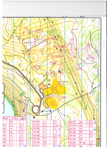
It also seems like the standard practice for sprint events in some places is not to quote the climb at all - even when it is quite significant as in the example (I wrote in the 135m).
The issue is really for the customer, mainly the not-quite-up-to-it sort. Elites will just enter it anyway (see tnipen, nothing to worry about), but it might influence doddery old vets and sprightly juniors as to which courses they enter if they know how much climb there is in advance. For a sprint event 4% climb is quite significant and would have changed my entry in this case, had I known about it.
Sep 19, 2010 10:17 AM
#
O-ing, that course was also part of the event where control 25 was put in the middle of the shallow water-filled horse jump so that the official photographer would have some different photos - and just about everyone had to go there ( with no choice about wet shoes late in an otherwise dry course)
Sep 19, 2010 12:05 PM
#
Ah yes, and having to do this rather contradicted the statement in the event information that it was forbidden to cross the horse jumps and therefore anyone doing so would be disqualified...
Sep 20, 2010 2:31 PM
#
AZ:
This was an ISSOM map? (I guess so from the water color at control 25). So wasn't the contour interval 2.5m?
Sep 21, 2010 12:50 AM
#
Thanks Delyn for answering my question! Much appreciated.
Thomas - that was awesome!
Thomas - that was awesome!
Mar 11, 2013 7:47 PM
#
Breathing life into a dead cat here... Orienteering Canada now seems to explicitly require that Sprint distances be measured around buildings. (IOF's and Orienteering USA's rules require the same, but very few organizers seem to follow the stated requirements—certainly not at the WOC level.)
For an organizer, it would seems like a nice productive use of my time, on top of the other hundreds of hours' worth of tasks, to open up OCAD or Condes for yet another round and click around with a measuring-tape tool or whatever seems handy at 11:30 pm on a weeknight before the event, following what I think is the best route as it curves around corners and climbs up and down stairs. Then enter into the webpage, then repeat for each remaining Sprint course. I'm not being completely facetious, it's not that hard nor a lot of time or effort compared with the rest of the tasks, and a similar process has to be followed anyway for the climb, and the extra morsel of information is perhaps worth the effort for the most anally inclined competitors who I perhaps want to keep as my customers. And there is no "but...", just a friendly reminder to other organizers, especially the ones in Canada.
And next, they should indeed require measurements of logs.
Mar 11, 2013 11:12 PM
#
That IOF rule has been the same, verbatim, since before ISSOM was invented.
This tells me how seriously to take it wrt ISSOM maps.
This tells me how seriously to take it wrt ISSOM maps.
Mar 12, 2013 12:15 AM
#
That's exactly my sentiment, but apparently not that of Orienteering Canada.
Mar 12, 2013 1:36 AM
#
All high-level Sprint courses in the U.S. that I recall in the past measured through buildings. So the rule has been consistently ignored.
Mar 12, 2013 4:34 AM
#
Well yes. It's also harder to run while juggling burning fireballs than to run.
Mar 12, 2013 4:48 AM
#
What I meant was it's easier on our volunteer workforce than it is to get them to do yet another task.
Mar 12, 2013 4:53 AM
#
pi:
Certainly. So perhaps we should just get rid of all our rules so it's easy to organize? Wait... that's a mud run... urgh.
Mar 12, 2013 4:55 AM
#
I don't think that is what tRicky advocated. The paper tiger gambit again.
Mar 12, 2013 5:49 AM
#
If the course is set to within the winning time guidelines and the distance is specified as either straight line or shortest available route and published to competitors as one or the other, where is the problem?
Mar 12, 2013 7:14 AM
#
The rule which defines the measure is quite sensible. Making an estimate by whatever method befits the event is also quite sensible.
Mar 12, 2013 7:49 AM
#
> No, just get rid of rules that don't make sense. Simple, eh?
I agree emphatically.
First off the list in Australia should be chest numbers. An anachronism.
I agree emphatically.
First off the list in Australia should be chest numbers. An anachronism.
Mar 12, 2013 8:09 AM
#
Clearly you've never worked in the finish when some plonker comes in at the head of a 20-strong pack and his SI tag isn't registered in OE. Chest numbers = win at that point. :)
Mar 12, 2013 8:13 AM
#
Whelp, now I can look forward to a half a decade where half of the meet organizers measure straight line and half of the meet directors measure around buildings.
Mar 12, 2013 8:19 AM
#
Does it actually matter? As tRicky said, the distance is defined by expected winning time, not straight-line distance. Presumably the setters would have to measure the actual distance in order to adhere to that, or else they're complete plonkers and everyone can post epic threads of tears on AP. Either way, orienteering wins.
Mar 12, 2013 8:39 AM
#
As far as club sprints go, an experienced setter can probably estimate what straight line length is needed to approximate expected winning times, based on their knowledge of the map and course and how far off the straight line runners will need to go. So, yes there is no need to go the extra task and measure the shortest practical route.
However, I've set two Australian Sprint Champs, and you can bet that I measured - and ran - the various routes, then used a factor to calculate my times back to what I thought the top elites would do. York had compulsory river and road crossings which were included in the course length, and at Mandurah (which was a canal development), the course lengths were measured to include the canal crossings, but not to include going around buildings.
However, I've set two Australian Sprint Champs, and you can bet that I measured - and ran - the various routes, then used a factor to calculate my times back to what I thought the top elites would do. York had compulsory river and road crossings which were included in the course length, and at Mandurah (which was a canal development), the course lengths were measured to include the canal crossings, but not to include going around buildings.
Mar 12, 2013 8:56 AM
#
There is also the problem that inevitably comes up (discussed at length already) about what is the 'shortest practical distance'. This will vary between different people. Straight line is consistent.
Mar 12, 2013 10:05 AM
#
I find this thread funny and so typical of our sport and discussion threads on Attack point.
Orienteering Canada put together a rules committee (which i was on) to review our rules following the 2010 Canadian Champs in Ottawa because Canada was criticized here on Attack Point for having a non IOF rule. Specifically Canada did not permit participants to cross uncrossable lakes or wetlands. I personally still think that was a good rule but the committee instead decided to remove the lake rule and follow IOF rules given the criticism. So we rewrote our rules to follow IOF and now within weeks of them being released Canada is being criticized on AP for following IOF rules this time. AP awesomeness at its best.
Orienteering Canada put together a rules committee (which i was on) to review our rules following the 2010 Canadian Champs in Ottawa because Canada was criticized here on Attack Point for having a non IOF rule. Specifically Canada did not permit participants to cross uncrossable lakes or wetlands. I personally still think that was a good rule but the committee instead decided to remove the lake rule and follow IOF rules given the criticism. So we rewrote our rules to follow IOF and now within weeks of them being released Canada is being criticized on AP for following IOF rules this time. AP awesomeness at its best.
Mar 12, 2013 10:28 AM
#
I think the common thread here is that Canada is being criticised, and rightly so - after all, they're not Australia.
Mar 12, 2013 10:44 AM
#
I am still puzzled as to why you are allowed to cross an uncrossable feature.
Mar 12, 2013 10:56 AM
#
@Juffy
Very true. ;-)
I found my volunteer time on the OC rules
Committee quite discouraging given how many rules the sport has and the volunteer time it takes to make sure you follow them properly. My club deliberately developed a variety of race formats that reduce the rules greatly to keep the volunteer efforts low and the fun factor high (they also just happen to be the most well attended races in Canada). It was interesting how many times during the rules review process that statements were made by other committee members that would have created barriers for my club to host our non standard race formats.Fortunately the rules got designed in a way to distinguish between rules for all events and the additional rules for Canada Cups (A meets).
Even so the sport has too many rules and while these rules are important for championships some/many of those rules (like T/D says) are just extra work for volunteers. Those extra rules aren't going to increase participation and membership and junior participation. There is a need to keep it simple.
anyway, i just found it ironic that the entire process to have Canada's rules to follow IOF was quickly used
as an example of not the right direction. :-)
On a related note I overheard a person complaining that GVOC measured some of their sprint races at sprint camp last month using the straight line. Really? The club hosts a dozen sprints in 48 hours on quality maps in a variety if terrain and organizes dinners and showers and you need to complain about that? As we say in Canada... Crikey!
Mar 12, 2013 2:50 PM
#
AZ:
Yeah, Hammer's got it. The rule is simply changed to be consistent with IOF - and consistency is good for the orienteer, for sure. For example, I use my favorite example from my Forbidden Features article - are you allowed to cross olive green? Well, it depends. ISSOM or not ISOM? What country are you in? Is this an IOF event, and if so are you running on a course than uses IOF rules or local rules? Brtutal. I applaud the rules committee for making the rules more IOF-compatible - so the questions will be reduced to one (ISOM or ISSOM)
As to the specific rule, sure it is silly. @simmo - did you measure and run all the routes for all the courses or just the elite courses? I know that I rarely run all all variations of all courses when setting/controlling. In fact, as an IOF controller I have never asked course planners to provide anything other that the straight line distance. Why not? Well, as tRicky (that paragon of orienteering sensible-ness) points out, I figure if the winning time is right, the terrain-type reasonably described, and the straight-line distance provided, then any runner will be able to estimate relatively accurately how long they will take and thus be able to prepare properly.
I think this is a rule the IOF could consider amending, since I don't see any value to it, and the cost (in volunteer time especially) is high.
Mar 12, 2013 3:39 PM
#
@tRicky -
Since the winning time is known, and the running speed of the top competitors is known, the optimal distance is easy to calculate.
...and that's how I propose following the rule.
Since the winning time is known, and the running speed of the top competitors is known, the optimal distance is easy to calculate.
...and that's how I propose following the rule.
Mar 12, 2013 10:50 PM
#
I am still trying to figure out in what instances you can cross uncrossable features, other than the apparent "I am a novice - I did not know any better". This seems to be a rather more strict rule than whether a course setter publishes straight line distances rather than shortest route.
Mar 12, 2013 11:25 PM
#
I walked through an uncrossable swamp recently. Seeing as how it was bone dry, it turned out not to be a reliable catching feature.
Mar 12, 2013 11:26 PM
#
I'm not sure about MTBO, tRicky, but we beat crossing uncrossable features to death in this thread (328 posts, but maybe 100 due to a brilliant hijack): http://www.attackpoint.org/discussionthread.jsp/me...
Mar 12, 2013 11:54 PM
#
It's really not that hard to measure shortest route. And you don't have to go crazy making sure you optimize the living daylights out of every tiny route choice, you just pick something that looks reasonable and it will be close enough. Nobody is going to complain if you said it was 3.3 km and there's a way to get around it in 3.1. In many cases, straight line and shortest route are pretty close together. In other cases, shortest route might be 40% longer than straight line, and straight line becomes a meaningless number that's not even worth listing. In those cases, figure out the shortest route.
Mar 13, 2013 12:52 AM
#
Diversion.
@Juffy.
yes I have.
My gripe is that we introduce new technology to the sport but don't re-engineer our processes to take full advantage of that technology. Chest numbers are a relic of the manual finish recording era. Without them we wouldn't need to man a registration tent for the first three days of the coming Easter carnival. It could just be an information tent. The solution to your scenario isn't chest numbers but a competitor maintained registration component of an on-line entry system. If a competitor finishes with a wrong number, then save the result and ask them to talk to the person dealing with problems and get back to the other 19. Don't try and solve it while the other 19 wait. They will have created the mismatch by bringing the wrong stick, losing a stick or miscoding a stick number. They should be happy to stand aside for a few minutes while it is sorted.
Mar 13, 2013 1:11 AM
#
I don't think I was alive back when that thread was in full swing.
Anyway, our local sprint orienteering events explicitly forbid the crossing of "uncrossable features" (high walls, fences, garden beds, lakes, other OOB) yet people still manage to do it. If you are allowed to cross uncrossable features, why would there be a difference between the straight line distance and shortest route - surely you can just run over everything!
As to MTBO, well that's another country specific thing. In the recent WOC, it was perfectly legal to ride/run your bike through bush. In Australia, it is forbidden.
Mar 13, 2013 1:26 AM
#
@ AZ - I ran all the legs of the M21E course, one leg at a time, flat out sprinting (if an M65 can be said to be capable of a sprint), with a minute or two rest between each leg. Afterwards, Mr Garmin gave me the leg/course lengths. This gave me more than enough information to work out the lengths of the other courses. Aside from that, it was much more fun, and a good workout, compared to sitting at a screen measuring course lengths in OCAD.
@ tRicky - read AZ's article - and stop using the word 'uncrossable', particularly in relation to sprint events (see below). The guts is that for all but sprint events you can go anywhere except out of bounds (marked with purple or black vertical hatch or a thick purple line) or forbidden routes (marked with purple X). If you feel like crossing an 'impassable' cliff, 'uncrossable' marsh, high fence, etc then you can and you will not be disqualified.
For sprint events, many features and routes are 'forbidden to cross, pass through or over' - even though some competitors might be capable of crossing them. The word 'uncrossable' does not appear in the ISSOM.
Mar 13, 2013 1:37 AM
#
The main thing that I'm picturing in my head in terms of obstacles when I'm thinking about determining the shortest route for a sprint course is buildings. Forbidden or not, running over a building is not usually going to be practical.
Mar 13, 2013 1:44 AM
#
tRicky I was adding the above in response to your earlier comment, while you were simultaneously posting. Hope you've got the difference between 'uncrossable' and 'forbidden to cross' sorted now.
In relation to our local events, they are not the WOC, and we can't monitor the whole course (or any of it really, except what might be visible from the start/finish) to ensure there are no crossings of forbidden areas. It's absolutely of no use to the organisers to read about these, with no names mentioned, the following day in Attackpoint (or get an email 2 days later, again with no names, as happened with a recent event). Besides, as someone who is running as hard as they can to win the event, are you a reliable witness of such crossings? Are you going to interrupt your race to stop the person, take their name and report them?
In relation to our local events, they are not the WOC, and we can't monitor the whole course (or any of it really, except what might be visible from the start/finish) to ensure there are no crossings of forbidden areas. It's absolutely of no use to the organisers to read about these, with no names mentioned, the following day in Attackpoint (or get an email 2 days later, again with no names, as happened with a recent event). Besides, as someone who is running as hard as they can to win the event, are you a reliable witness of such crossings? Are you going to interrupt your race to stop the person, take their name and report them?
Mar 13, 2013 2:08 AM
#
Do you want me to report such people in the future? Brian Hardy and I both witnessed the same two people crossing OOB at Murdoch and pointed it out to both at the time yet they continued through the area. One I knew, admittedly the other I did not. Are you saying I'd be unreliable because I have oxygen deprivation so may have dreamt up what I saw?
Perhaps I meant 'impassable' rather than 'uncrossable' (a word that regularly features on some of our maps - hence the reason I am apparently confused over terminology). Oops, sorry I used the word uncrossable again. I shall strike it from my vocabulary immediately.
I can't believe it took you 15 minutes to type that
Mar 13, 2013 2:36 AM
#
From the Orienteering Australia rules:
16.3 The course lengths shall be given as the length of the straight line from the start via the controls to the finish deviating for, and only for, physically impassable obstructions (high fences, lakes, impassable cliffs etc.), prohibited areas and marked routes.
Also Appendix 8.1.2:
As urban sprint maps contain significant un-crossable areas (buildings etc), general practice is to measure sprint courses as the straight line distance for these maps. As this is not strictly in agreement with Rule 16.3 which was designed for courses in a forest setting, the organiser should advise in the event information how the course distance is measured. The course planner should however calculate the expected actual running distance to ensure that the courses will meet expected winning times.
Mar 13, 2013 4:27 AM
#
I can't yet find the time to read in detail the careful thought displayed herein, so everyone is entitled to summarily disregard this comment as well.
At any rate, I don't know what people are advocating, but setting a sprint, WRT to winning time (which I think is arguably of greatest import in sprint of the major disciplines) is also the easiest of the major disciplines. A competent course setter (and maybe some might say there are none in North America--sorry, I digress) should be able to hit a sprint winning time to within 20 seconds. There is not that much variability in the outcomes, and if there is, I submit there may be something wrong with the course.
So, if that is the case, the distance thing is just sort of silly.
That said, and from my unfrozen caveman lawyer perspective, I say measure straight-line distance. Which is perhaps logically inconsistent. But, you don't want to get me started about the 'uncrossability' semantics inherent in ISSOM vs. ISOM and the injustice of holding a competitor to the ISSOM normative standards when using a map which is unabashedly ISOM. (Yes, I'm still getting over March 2005.)
Mar 13, 2013 5:37 AM
#
First off the list in Australia should be chest numbers. An anachronism.
Chest numbers are a relic of the manual finish recording era.
Really? Numbers do so much for identifying. If you have live announcing and an arena, spotters can relay competitor numbers so that you know who is coming in. If you witness someone breaking a rule, you can identify the perpetrator.
There are reasons why many sports on this planet have identifying numbers in visible locations on athletes.
Mar 13, 2013 5:50 AM
#
Yes the paragon of orienteering sensibleness agrees with this. I figured we were wearing numbers at the weekend's national league races for commentary and rule breaking purposes, more so the former than the latter since Elites do not break rules.
Mar 13, 2013 6:29 AM
#
Bibs with numbers are beneficial in many ways. I run the download station a lot, and a certain number of people always end up running with different SI numbers. The bib helps that immensely---If the download doesn't work, I just enter the bib number, and that takes care of it 95% of the time.
Perhaps the biggest "intangible" benefit is that people see the bib and assume you're doing something "official".
At last year's relay champs, the bib numbers made it easier to accept teams that were formed just an hour before the relay start. (And yes, it was still very stressful, but the bib numbers made it easy.)
I'd agree to skip bib numbers under two conditions: 1. We're not having a relay sometime during the event, and 2., We're *not* having a lot of school-age competitors (who often accidently swap SI dibbers). If it is an Interscholastic event, just issue bibs or I will lose my mind.
Mar 13, 2013 11:08 AM
#
bubo:
If you feel like crossing an 'impassable' cliff, 'uncrossable' marsh, high fence, etc then you can and you will not be disqualified.
Maybe someone has commented above (I haven´t read everything yet) but is that really true? There definitely have been disqualification(s) in Sweden for crossing an "impassable cliff" at a sprint event in Sweden...
As far as I know - by definition the "impassable" is automatically forbidden!
PS. Read your post again and realize I may have misunderstood what you meant, but will leave my comment...
Mar 13, 2013 11:30 AM
#
Bubo - please try not to upset Simmo. You will make him uncrossable.
Mar 13, 2013 1:45 PM
#
AZ:
@bubo - you haven't read my article ;-) Here's a synopsis:
1. in general, when interpretting ISOM and ISSOM then you must (according to the IOF) realize that "uncrossable" is not the same as "forbidden".
2. in ISOM there are only five "forbidden features", and in general "uncrossable" mean 'difficult to cross' (so it is not illegal to cross an 'impassable cliff').
3. in ISSOM there are many "forbidden features" - they are specifically identified as forbidden and will result in DSQ if you are caught, or if you 'fess up.
4. In any case, the Swedish rules might trump the ISOM / ISSOM in non-IOF events (like in Canada where, for example, crossing olive green on an ISOM map is illegal, even though olive green is not a forbidden feature)
Mar 13, 2013 2:44 PM
#
In sprint events impassable cliffs are forbidden to cross. This came about partly because in an early international sprint event all competitors had to jump down a castle wall, and the organisers even put mattresses at the bottom to land on. The inevitable happened and a competitor suffered a severe spinal injury.
Determining whether a cliff is impassable or not is the task of the mapper. Every cliff is different, and every mapper has a different viewpoint. Remember that a mapper is trying to draw a picture of the terrain and might use a thicker cliff line in certain places where some elites would not hesitate to jump down. The ISSOM rules are designed to prevent more physically/physiologically capable, courageous, perhaps foolhardy competitors from gaining an advantage by taking a potentially dangerous route that others would not attempt. ISOM is not so prescriptive, but perhaps in a longer distance race there is less to be gained and more to be lost by jumping down a high cliff, so competitors generally don't do it.
Determining whether a cliff is impassable or not is the task of the mapper. Every cliff is different, and every mapper has a different viewpoint. Remember that a mapper is trying to draw a picture of the terrain and might use a thicker cliff line in certain places where some elites would not hesitate to jump down. The ISSOM rules are designed to prevent more physically/physiologically capable, courageous, perhaps foolhardy competitors from gaining an advantage by taking a potentially dangerous route that others would not attempt. ISOM is not so prescriptive, but perhaps in a longer distance race there is less to be gained and more to be lost by jumping down a high cliff, so competitors generally don't do it.
Mar 13, 2013 4:20 PM
#
AZ:
Besides this issue of fairness, the ISSOM is also designed to keep runners out of forbidden areas, and there are way more forbidden areas in urban environments than in the forest. Keeping runners out of forbidden areas is pretty important to ensure future access to the terrain.
(which is why this in in ISSOM...
The course planner should not encourage unfair actions from the competitors, such as crossing barriers or areas with forbidden access. If it is unavoidable to set legs that cross or skirt areas with forbidden access or impassable walls and fences, then they have to be marked in the terrain, and observers should be present at the critical points.)
Mar 13, 2013 4:58 PM
#
bubo:
An interesting scope on this 'impassable/uncrossable' debate may be what was brought up at a team leader´s meeting at WOC a few years ago.
After being out on the model map someone specifically asked about the distinction between crossable/uncrossable fences on the map. A tall runner would have had only minor problems - if any at all - to cross a 'crossable' fence (as was the case for the ~2m tall mapper) while to a 150cm Japanese girl this would have been surely uncrossable. In the sake of fairness this means that the tasks of the mapper and course setter are very important for the race to be totally fair and the rules also very clear on what is allowed or not.
After being out on the model map someone specifically asked about the distinction between crossable/uncrossable fences on the map. A tall runner would have had only minor problems - if any at all - to cross a 'crossable' fence (as was the case for the ~2m tall mapper) while to a 150cm Japanese girl this would have been surely uncrossable. In the sake of fairness this means that the tasks of the mapper and course setter are very important for the race to be totally fair and the rules also very clear on what is allowed or not.
Mar 13, 2013 7:39 PM
#
Interesting also to us pedants is that the as-cribbed IOF rule says
" deviating for, and only for, physically impassable obstructions (high fences, lakes, impassable cliffs etc.), prohibited areas"
So the course measurement should cross any ISSOM line feature which is legally "uncrossable" but physically passable... Even though the competitors can't go that way !?!?
just to emphasize how this rule makes no sense in ISSOM...
Mar 13, 2013 8:59 PM
#
Indeed—so Canadian Sprint organizers should first check whether there may be open doors to shortcut through each affected building, and if yes, they should measure the course length through those open doors.
Mar 13, 2013 9:24 PM
#
No, buildings are "areas". Only doors/gates in walls need checking.
Do keep up :)
Do keep up :)
Mar 13, 2013 9:53 PM
#
Canadian Sprint organizers should first check whether there may be open doors to shortcut through each affected building, and if yes, they should measure the course length through those open doors.
I unknowingly ran through a building at the 2010 sprint in Whistler Village. I was looking for a building pass-through, and as I was approaching, I saw a way through the building (I could see unobstructed sunlight coming from the other side). This "pass-through" was 25m from the one I needed.
I ended up running through an open double door, through a hotel lobby and out the other side (through another open double door).
I suppose I should be DSQ for this, but it certainly didn't gain me an advantage, because I couldn't find the control where I was looking for it, and I didn't understand what I'd done until much later.
This discussion thread is closed.