Discussion: Deerfield Academy
in: PG; PG > 2013-12-24
Dec 28, 2013 5:18 AM
#
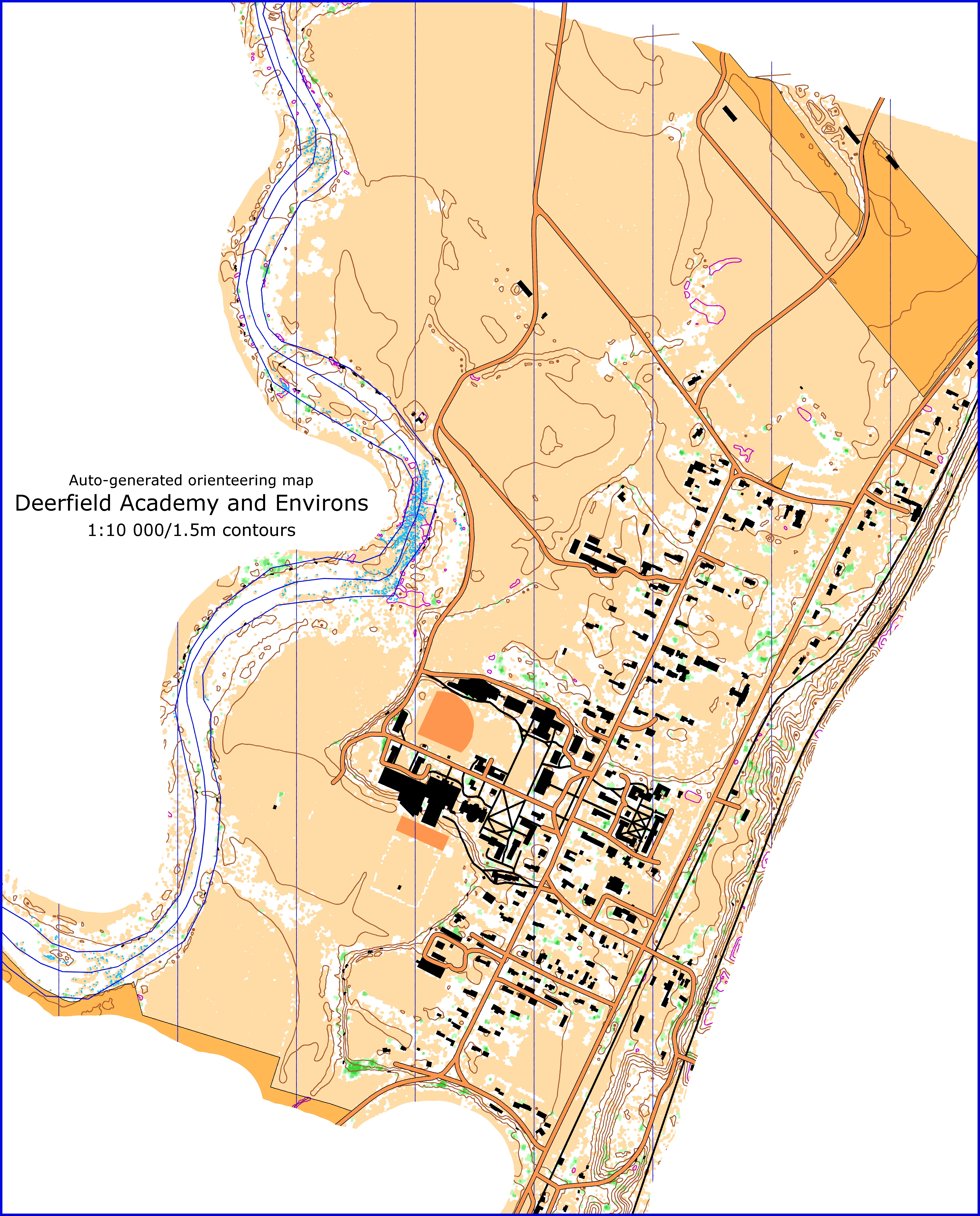
Fiddling with semi-auto-generated maps these days, so did the Academy using Jagge's Karttapullautin (so no ISSOM, only ISOM @ 1:10K). Only a raster image ... if you're interested in ANY of the other files (LAZ, contours, OSM shape files) just let me know.
Neat stuff. It's kind of a huge map ... you might have to fiddle to make it print in a reasonable fashion (without 'shrinking to fit' or some such).
The purple 'contours' are depressions.

Neat stuff. It's kind of a huge map ... you might have to fiddle to make it print in a reasonable fashion (without 'shrinking to fit' or some such).
The purple 'contours' are depressions.
Dec 28, 2013 7:55 AM
#
Nice. If you want more practice, try adding the Eaglebrook School on the other side of the road.
Dec 28, 2013 4:59 PM
#
Sounds good jjcote! Send me an image with a bounding box and I'll crank one out. Same with this one too if you want something different PG, just draw a rectangle on a Google map and I'll do a quick map.
And if anyone is interested in the raw stuff to import to OCAD let me know.
And if anyone is interested in the raw stuff to import to OCAD let me know.
Dec 28, 2013 6:16 PM
#
Did you get the LAS files from Massgis for the Hudson/Hoosic dataset, or are you just working off of their DEMs?
I have all the raw data for everything else they have, but not that dataset. I'd like to get it without having to pay MassGIS again.
http://www.mass.gov/anf/docs/itd/services/massgis/...
I have all the raw data for everything else they have, but not that dataset. I'd like to get it without having to pay MassGIS again.
http://www.mass.gov/anf/docs/itd/services/massgis/...
Dec 28, 2013 6:25 PM
#
LAS from NOAA. Soooo many now available there, and in an awesome format too:
http://www.csc.noaa.gov/dataviewer/index.html#
Unbelievable! Pre-converting the files to my favorite projections! :)
http://www.csc.noaa.gov/dataviewer/index.html#
Unbelievable! Pre-converting the files to my favorite projections! :)
Dec 28, 2013 6:56 PM
#
PG would be a better one to draw the bounding box, since he actually runs there. gmap-pedometer is an easy way to do that. Try to include the radio tower, Peter :-)

Dec 29, 2013 4:46 AM
#
On the southern part, it would be great if it included some more west of the road, south of Deerfield Academy, so we could get the landing zone as well. Just continue the southernmost segment directly west until it hits that white grid line, then go north. :-)
Dec 29, 2013 5:31 PM
#
Hugh, I've been messing with Kartapullautin a bit lately as well. Curious where you're pulling building data from. Is that all manual post-processing from aerials or do you have an auto means of pulling that in?
Dec 29, 2013 6:16 PM
#
OSM. That whole map, other than the text I added on the left and cutting off some of the edges, was entirely Karttapullautin produced!
Basically I followed Jagge's instructions in the City Park Maps discussion. Here is some expansion:
From Jagge: http://www.attackpoint.org/discussionthread.jsp/me...# (Jagge, you rule!)
Software
You will need:
- Karttapullautin (http://routegadget.net/karttapullautin/) AT LEAST 20131215 version!!
- lastools (http://www.cs.unc.edu/~isenburg/lastools/download/...)
- GDAL/OGR (I used the FWTools package: http://fwtools.maptools.org/)
LIDAR Data
http://www.csc.noaa.gov/dataviewer/index.html#
Zoom in to your area, use the "draw area" tool, then "Data Type" elevation (a filter), and find the latest (probably at the top) appropriate LAZ file. Add to cart.
When you "Checkout", check the "Let me edit choices" checkbox, and:
Projection: UTM
Zone: 19N <-- this may change depending on where you are, but it should pick the right one automatically
Horizontal and Vertical Units: Meters
Horiz Datum: NAD83
Vert Datum: NAVD88
Output: Points
Format: LAZ
Data Classes: All
Create a working directory, let's call it: C:\maps\map1
When you get the e-mail from NOAA, download the zip file and save the .laz file as download.laz
# thin the data if you like, and break into smaller tiles if you like (neither is necessary)
lastile -i download.laz -o "in" -olaz -tile_size 2000 -keep_random_fraction 0.25
Create an in directory in your working dir. Move the in*.laz file(s) there (OR download.laz if you didn't do the above processing)
OSM Data
http://www.osm974.re/osm2gis/
Scroll and zoom around to include the area you want. Send it to yourself (NOTE: only one download per hour, so be careful :))
When you get the dowload file, save it to your working dir. Copy out all of the osm_line and osm_polygon files (from the zip) ... no need for point files) then using ogr2ogr transform the projection for the polygon and line shape files so they will align with the LIDAR file:
Open an FWTools Shell
ogr2ogr -skipfailures -f "ESRI Shapefile" line.shp osm_line.shp -t_srs EPSG:32619 <--this number is for UTM 19N ... 32618 is UTM 18N. Don't know others!
ogr2ogr -skipfailures -f "ESRI Shapefile" osm_polygon.shp osm_polygon.shp -t_srs EPSG:32619
Now re-zip up all of the new line and polygon files to in.zip, and put that in your 'in' folder.
Karttapullautin
Unzip the karttapullautin software into the working dir. You'll also need to put las2txt.exe from the lastools 'bin' directory as well.
Edit the pullauta.ini file (I like to save an 'original' version of this too):
- northlinesangle
- batch=1
- processes=# of laz files you have, OR number of "cores" your computer has, whichever is smaller
- vectorconf=osm.txt <-- that's for the OSM file you downloaded!
- other stuff (water, scaling, etc, look around)
You're ready to run pullauta (double-click it!)
Enjoy! I hope that's helpful cmorse.
Dec 29, 2013 7:11 PM
#
thanks, I've got (and have used) most of that software before, but very handy to spell it out in a logical workflow...
Dec 29, 2013 7:19 PM
#
I forgot to mention: you need the latest version of Karttapullautin (20131215, very new!) for the OSM stuff to work correctly, too.
Yes, I have to work that way (copy/paste is my friend!) or everything breaks and I'm sad. :)
Yes, I have to work that way (copy/paste is my friend!) or everything breaks and I'm sad. :)
Dec 29, 2013 7:23 PM
#
thanks for that last note. I might have been wrestling for hours until I figured that one out....
Dec 29, 2013 8:07 PM
#
PG:
Usually I feel like I don't understand a bunch of stuff on other people's logs. Now it seems I don't understand a bunch of stuff on my own log. :-)
I wonder what the average IQ is of folks on AP. Must be pretty high.
I wonder what the average IQ is of folks on AP. Must be pretty high.
Dec 29, 2013 8:28 PM
#
Now it seems I don't understand a bunch of stuff on my own log. :-)
But if it means quick & dirty O maps, it can't be all bad, right?
But if it means quick & dirty O maps, it can't be all bad, right?
Dec 29, 2013 9:42 PM
#
I'm a tinkerer PG, not a high IQ type, but have spent many many (way too many, just ask JKoczak) hours fiddling with this stuff so I'm starting to figure it out, and want to help others so they don't have to face the massively steep learning curve that (it sure felt like) I did.
Dec 30, 2013 1:36 AM
#
Sounds like this could be a great way to get the other four colleges mapped, and hold a one-day, five college sprint championships.
Dec 30, 2013 4:12 PM
#
OSM data is hardly good enough for sprint mapping as it is. Plenty of mapping needed. Lidar contours-cliffs only map is out of the box much more usable than OSM. Not for racing, but as some sort of training camp supplement.
I had to try NOOA site hughmac4 linked. Nice! This clip is a bit east from Deerfiled, overlaps with Kenneth M Dubuque Memorial State Forest.
https://picasaweb.google.com/lh/photo/1un9co9AqOsj...
I had to try NOOA site hughmac4 linked. Nice! This clip is a bit east from Deerfiled, overlaps with Kenneth M Dubuque Memorial State Forest.
https://picasaweb.google.com/lh/photo/1un9co9AqOsj...
Dec 30, 2013 6:39 PM
#
As Jagge mentions, if you actually want to use this stuff for events (where people pay money, or kids learn, or something) you probably need to do a bunch of field checking, and work in OCAD/OOMapper, etc. But the quality of the OSM data is indeed pretty variable, therefore suspect. The Deerfield data looks surprisingly GOOD ... I think I need to re-render at some point with a modded osm.txt file to turn the train tracks to train tracks instead of ... road?
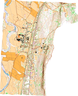
The lidar from the NOAA site didn't cover the whole area you wanted PG/jjcote ... here's what they had:
If you want the dxf (Karttapullautin), shape (OSM), and vegetation map (Karttapullautin) files I used, say to import to OCAD, just let me know and I'll send you a link to the folder (I'll not expose that here). I also have an OCAD CRT file to import all of the Karttapullautin data at once, assigning all of the right symbols to the objects. I have one for OSM data as well, but it's for OSM downloaded from http://extract.bbike.org/, not the one used here. Again, let me know if you're interested in any of this stuff and I'll get links to you (whoever you might be!).
Maybe edwarddes has the LIDAR to the east? Ed?
The lidar from the NOAA site didn't cover the whole area you wanted PG/jjcote ... here's what they had:

If you want the dxf (Karttapullautin), shape (OSM), and vegetation map (Karttapullautin) files I used, say to import to OCAD, just let me know and I'll send you a link to the folder (I'll not expose that here). I also have an OCAD CRT file to import all of the Karttapullautin data at once, assigning all of the right symbols to the objects. I have one for OSM data as well, but it's for OSM downloaded from http://extract.bbike.org/, not the one used here. Again, let me know if you're interested in any of this stuff and I'll get links to you (whoever you might be!).
Maybe edwarddes has the LIDAR to the east? Ed?
Dec 30, 2013 8:09 PM
#
set GDAL_DATA=C:\Program Files\GDAL\gdal-data
"c:\Program Files\GDAL\ogr2ogr" -skipfailures -f kml line.kml osm_line.shp
"c:\Program Files\GDAL\ogr2ogr" -skipfailures -f kml polygon.kml osm_polygon.shp
thats what I say to check how OSM looks in google earth. There is plenty of administrative border lines and lines on each other, but if you click off the object you clicked you will see what is uder it and find something you could use for drawing.
There is no symbology for railroad in Pullautin at the moment, it's drawn as thick black line.
---
I could not resist starting yet an other batch run of NOAA lidar + OSM. Should be done by tomorrow morning, here clip of the area it has done so far.
https://picasaweb.google.com/lh/photo/uDftMOsu4IIN...
I think thats part of Harriman or quite close to it.
Dec 30, 2013 9:24 PM
#
Nice, Jagge. Cool way to check on the accuracy. Thanks! Train tracks: ah! No worries, just thought I needed to fiddle. :)
Dec 31, 2013 3:48 PM
#
Thats the edge of the lidar data. There is a gap before you hit the FEMA Nashua data. They have been doing the collection along the HUC8 watershed boundaries, approximately. That dataset is supposed to be the deerfield and hudson-hoosic. The next one east that is done is the Nashua. The Middle Connecticut would be just to the east of the Deerfield, and is very narrow, and then the Miller on the other side of the river.
Dec 31, 2013 6:32 PM
#
PG:
Is the lidar in the NW part of the state which was used for this actually any good?
What I used for the Earl's Trails map, lidar that covered the Town of Amherst that was processed by Eddie, was wonderful, contours virtually perfect. Any sense if this stuff is similar?
What I used for the Earl's Trails map, lidar that covered the Town of Amherst that was processed by Eddie, was wonderful, contours virtually perfect. Any sense if this stuff is similar?
Dec 31, 2013 10:21 PM
#
The Hudson-Hoosic dataset was only specced to be max 2.0m post spacing. It may have been collected better than that though, I haven't looked at the data yet.
Some of the really great datasets in MA are at 0.6m NPS, which allows for awesome 0.5m contours, and a really good detailed set of hill shade, slope, and unsharp background images.
The 2m NPS set will still make good 2.5m contours for a map, but a lot of the smaller trails and linear features that you may have been able to pick up in a denser dataset may not show up.
I can't find a good set of metadata for the Amherst set, but I think it is <1m NPS.
This discussion thread is closed.