Discussion: Updates, please
in: 12th World Rogaining Championships (Aug 16–17, 2014 - Rapid City, SD, US)
Aug 17, 2014 3:51 PM
#
So bummed I couldn't find how to watch some of my faves who went. Anybody have updates, commentaries, stories? Loved seeing pix here and on FB. And, fans want MORE! :)
Aug 17, 2014 4:40 PM
#
Ah! Us east coasters forget about time changes! And, spoiled by live tracking for big events.
Aug 17, 2014 5:41 PM
#
Almost nothing on twitter: https://twitter.com/search?q=12WRC2014
Aug 17, 2014 10:25 PM
#
PG:
Well, then I suppose if I report that it happened, that's news. But I haven't a clue about results as nothing had been posted when we left an hour after it was over.
Perfect weather, no one died, the woods ranged from nice enough to atrocious, the map ranged from very nice to atrocious as expected for a rogaine. Very glad I went but, sorry, no idea how anyone did.
Perfect weather, no one died, the woods ranged from nice enough to atrocious, the map ranged from very nice to atrocious as expected for a rogaine. Very glad I went but, sorry, no idea how anyone did.
Aug 17, 2014 10:45 PM
#
Results are delayed until tomorrow at the earliest. Big SI issues and they kept all of the sticks and will return them by mail. That's what they announced, and I don't know anything more.
There was one major medical emergency requiring a helicopter medivac to Rapid City this morning.
There was one major medical emergency requiring a helicopter medivac to Rapid City this morning.
Aug 17, 2014 11:00 PM
#
PG:
I believe it was Bob Reddick's partner Ken Lew, broke his hip.
They didn't keep all of the SI sticks, I know that for sure (they weren't doing it when we checked in about 30 minutes early).
JJ says he heard there were two controls that had the same internal code, and the finish box had the wrong date, or something like that.
They didn't keep all of the SI sticks, I know that for sure (they weren't doing it when we checked in about 30 minutes early).
JJ says he heard there were two controls that had the same internal code, and the finish box had the wrong date, or something like that.
Aug 18, 2014 3:24 AM
#
I am shocked that the results weren't available soon after the conclusion of yet another WRC. Does this mean the event schedule lied to me?
Sunday, August 17th
1100 -- Meal opens
1200 -- Champs finish
1300 -- Awards ceremony
Sunday, August 17th
1100 -- Meal opens
1200 -- Champs finish
1300 -- Awards ceremony
Aug 18, 2014 4:46 AM
#
JJ says he heard there were two controls that had the same internal code, and the finish box had the wrong date, or something like that.
Looking over our results, I see that we punched 44 but it was recorded on the splits printout as 33.
Looking over our results, I see that we punched 44 but it was recorded on the splits printout as 33.
Aug 18, 2014 5:14 AM
#
In order for any Rogaine event to be successful you need a decent map, controls in the right locations, decent food, and it would be nice to have results and awards and ceremony after event is done. It was a lot of energy wasted on control of any sort of electronics (watches, gps trackers, smart phones, etc.) and complete failure on actual event technology side - SI-10/11 for some reason did not work at download stations. However, not to be completely negative, maps printing quality was the best ever used at Rogaine events. Other aspects of organization were great.
Greg Balter.
Greg Balter.
Aug 18, 2014 6:36 AM
#
The food was great, I think. And the volunteers at the water point where I had to pull out of the race (w5) were really nice and helpful. Overall, I had a great time despite having to quit the race early. On the downside, control 32 (one of the closest to the competition center) was still missing/misplaced 2 hours before the finish (I assume we were not the only team reporting it) and a couple of control locations (85) should perhaps not have passed the vetting process. And I completely agree with Greg that it makes very little sense to be so strict with electronic devices in amateur events like this. There are clearly much bigger swing factors to straighten out first before worrying about people trying to cheat using various electronics for navigation.
Aug 18, 2014 8:00 AM
#
You should all come to Alice Springs in 2016, then you can see how Straya puts on a rogaine (again).
Aug 18, 2014 5:38 PM
#
We found #32 by dumb luck after a 15 min. search at night. The control was hung about 150 meters north from the center of the circle, about 2 contours down, on unmapped fence. While general visibility in that area was good it was well protected from saddle by a wall of young spruces. I do understand that tremendous amount of work goes into making of 200 square miles map and a lot of this is volunteer labor, but in my opinion it was a big mistake to omit 50% of trails and roads, do not map barbwire fences, open areas, old and recent clear cuts, and dangerous cliffs next to control locations. Most of this does not require field checking and could be done with areal or satellite imagery, most of it publicly available.
Aug 18, 2014 6:06 PM
#
A 300 km2 map, with a surveyed road network and fences, fieldchecked cliffs, and clearcuts if only from photos, in addition to accurate contours and watercourses? All this on top of an all-you-can-eat buffet, prompt results, and hot showers in the middle of nowhere? It seems that you mean "a $250 entry fee".
Aug 18, 2014 6:47 PM
#
I would like to help organizers, and ask fellow competitors who read attackpoint: post your scores here. I will start with us.
Team Speedy Goats (#187), USA - 2830 points in 23 h 43 m.
Team Speedy Goats (#187), USA - 2830 points in 23 h 43 m.
Aug 18, 2014 6:59 PM
#
The problem is that not all competitors are fond of keeping the exactly accurate score in their heads at all times. And even if they are, sometimes said heads malfunction, you think you got X points but in reality it is 0.95 X.
Aug 18, 2014 7:09 PM
#
Team Almost Tested Positive (#300), Morse/Coté/Linder, 1390 points, about 18 hours officially although we were back at the HH after about 16 hours but didn't decide to bag it until after we took a nap. (Not from malfunctioning memory, I have a map to look at.)
Aug 18, 2014 7:29 PM
#
revy:
A bit of thread diversion but why not charge a higher entry fee if that is what it would take to prepare a proper map? I spent several hundred dollars on travel and accomodation - a hundred or even two hundred dollars more would have been perfectly fine with me. Given the amount of non local participants the entry fee is not likely the limiting factor for registration numbers.
Seems like we weren't the only ones who almost walked off a cliff several meters from a control in the middle of the night?:)
Seems like we weren't the only ones who almost walked off a cliff several meters from a control in the middle of the night?:)
Aug 18, 2014 7:50 PM
#
Yes indeed. Why... oh why... not charge... a higher fee... if that's what it would take to do things properly. My fingers, save me from hyperlinking a different Attackpoint thread to each of the above words. Or letters.
Aug 18, 2014 8:38 PM
#
What level of fees are necessary to "do things properly" in the context of US orienteering?
This (the WRC) seems to be couched (just above) as an instance of corners being cut due to inadequate entry fee revenue leading to compromised fairness/competitive experience. Do I understand correctly?
You seem to be implying this is not an isolated incident. Can we consider the evidence?
This (the WRC) seems to be couched (just above) as an instance of corners being cut due to inadequate entry fee revenue leading to compromised fairness/competitive experience. Do I understand correctly?
You seem to be implying this is not an isolated incident. Can we consider the evidence?
Aug 18, 2014 9:57 PM
#
Other competitive outdoor activities; yes; "why should I pay for X when (a) I'm not personally, passionately interested in X or (b) my friends always do X for free"? I'm outta here.
Aug 18, 2014 10:31 PM
#
$125 a piece? This weekend's 24 hour race (Thunder Rolls), non World Champs, is $240 per person. The 17 hour cut off Ironman your local officemate is going is doing (eg, Louisville) is $625. And I think there are like two controls. 4 * my last six hour rogaine in Ohio is $220.
Airfare was going to be $550 from flyover country to the event; another $100 for the entry is a rounding error. Could $42k pay for the mapping?
Airfare was going to be $550 from flyover country to the event; another $100 for the entry is a rounding error. Could $42k pay for the mapping?
Aug 18, 2014 11:04 PM
#
PG:
There is an update on the results situation on the Peak blog, link from the event website.
Aug 19, 2014 12:45 AM
#
We charged I think $35 per person for our local 24hr event the weekend before and everyone was happy with the map, the event overall (although we ran a bit short of barbecue food but that wasn't a cost issue - just undercatered) and we got just as many people as the WRC. Increasing the entry fee would drive away our social competitors but then who wants them at a World Champs anyway?
I did my best to update the map from aerials (on a volunteer basis) but being a rogaine map, we didn't map clearings, bush etc (it was 80% farmland) although I did map pine forests and dams and did my utmost to correct the watercourses, which were wrong from the base data. With such a huge area to cover, including every little detail on the map is not cost effective. It's not orienteering.
I did my best to update the map from aerials (on a volunteer basis) but being a rogaine map, we didn't map clearings, bush etc (it was 80% farmland) although I did map pine forests and dams and did my utmost to correct the watercourses, which were wrong from the base data. With such a huge area to cover, including every little detail on the map is not cost effective. It's not orienteering.
Aug 19, 2014 4:54 AM
#
I was only a spectator supporting a team, and was at the hash house a significant portion of Saturday and Sunday. The volunteers were plentiful, attentive, knowledgeable, helpful, etc. I explored the model map. It was not an orienteering map. I have heard that rogaine maps are more general than orienteering maps, with a lot less detail, so I was not surprised by the model map. From what I understand from the team I supported, the model map was representative of the competition map. As for fences, from what I saw, there's a lot of barbed wire in that area. If the map was truly 300km2, there may be hundreds or thousands of kilometers of new and old barb wire on that rogaine map. Barbed wire fences cannot be seen in aerial photographs. As a practical matter, for a rogaine, maybe it's unreasonable to expect the mapper to try to map them all, and if not trying to map them all, maybe unreasonable to expect the mapper to try to map only some of them. Anyway, that's my perspective, from a guy who was sitting comfortably in a chair while others were giving it their all.
Aug 19, 2014 5:05 AM
#
I can buy that the vegetation differences and fences are not represented on the map: fine!
However, you still would expect the roads to be represented in full: they should not stop in the middle of nowhere in case when they continue in real world. They should be either represented by one symbol or in accordance to their size or meaning. Having random roads on the map adds lots to randomizing the results.
However, you still would expect the roads to be represented in full: they should not stop in the middle of nowhere in case when they continue in real world. They should be either represented by one symbol or in accordance to their size or meaning. Having random roads on the map adds lots to randomizing the results.
Aug 19, 2014 7:50 AM
#
We do frequently get that complaint in WA regarding roads. Setters typically say 'Not all tracks/roads are shown and those that are, are not necessarily accurate'. If you find a non-accurate road - fix it!
Aug 19, 2014 10:22 AM
#
http://sportrec.navirec.com/ui/#19ujef8 where brothers Eensaar'e and Timmo Tammemäe went.
Aug 19, 2014 12:42 PM
#
I feel like one of those crotchety old guys, but weren't rogaines generally contested on USGS maps? When did the expectation of fieldchecking get introduced?
It is one thing to spot fieldcheck a map when you have one course with known routings, but when you have innumerable possibilities introduced in this type of course?
300k^2? The wisdom of charging a lot of money to sink into a rogaine map in the middle of nowhere seems like folly of the same sort as any number of Olympic venues over the year, but with even less justification.
Aug 19, 2014 1:25 PM
#
The USGS map had more roads than the map used in the competition. USGS maps are generally consistent maps. The map here used (a guess) USGS 10meter elevation grid (an approximation from the DEM used on TOPO maps) to generate 10m contours. Then the roads on the map came from some other - wildly non complete data source.
Aug 19, 2014 1:28 PM
#
Fieldchecking? No, but how about including major roads that are shown on the USGS and are also clearly visible in the satellite photos? And not including the ones that appear in neither because they don't exist?
Aug 19, 2014 1:51 PM
#
the forest person i talked to said that the USGS map of the are was done in 1960, so those are 50+ years out of date. the organizer mentioned before the event that the old maps did not give too much useful information.
effort was made to map the "motorized" roads in the area (roads useable by vehicles), but not the ever changing all terrain vehicle tracks or logging trails. perhaps a significant difference from some previous major events was that this was pretty much wilderness. routes between controls that looked straight forward on the map often turned out to be poor route choices due to terrain, downed trees, erc. some very demanding travel and need for a lot of navigation effort to avoid losing major time. i really liked the event.
effort was made to map the "motorized" roads in the area (roads useable by vehicles), but not the ever changing all terrain vehicle tracks or logging trails. perhaps a significant difference from some previous major events was that this was pretty much wilderness. routes between controls that looked straight forward on the map often turned out to be poor route choices due to terrain, downed trees, erc. some very demanding travel and need for a lot of navigation effort to avoid losing major time. i really liked the event.
Aug 19, 2014 2:38 PM
#
It doesn't appear that the new map gave much useful information either, judging by a comparison with Google Map and the various comments people have made.
Aug 19, 2014 2:38 PM
#
It is completely beyond me, why would one not use a 6 meter contours (USGS) publicly available data but go with 10 m source. I am looking at the USGS map of the event area and comparing to the race map.. just one example: CP 85 where many people had issues: There are three roads that pass around the checkpoint area, two of them relatively close-by. There is more details in the contours in the USGS map, so reading the terrain is easier too.
effort was made to map the "motorized" roads Ummmm, effort was attempted might be a better term, someone jumped in their truck turned the GPS, drove around the area, going on roads where they see them and arbitrary deciding "that's enough for this road here, I am turning back now"
There are so many avenues to get at least the road network data, google or bing imagery - no leg work, USGS - no leg work.
Aug 19, 2014 4:01 PM
#
So sorry for barging back in, what would a qualified estimate be to get the road/trail network in the entire area to Euro-standard? I am coming up with 60 workdays at $25k all-inclusive. By comparison, to get a superb results service was under $2k.
Aug 19, 2014 4:03 PM
#
Nikolay, where do you get the USGS? The servers they used to have the scanned maps on don't seem to reply or exist since early this year.
Aug 19, 2014 4:14 PM
#
Basemaping service from photos/lidar derived products is going to run you at least $50/sqkm to have someone sit there and trace features. I just looked at the google photos, and the road network is very visible. Just based on those photos I could have produced a map with a lot of the cliffs, all the roads, and some approximation of the open areas in the bottoms of valleys.
Results service pricing would probably have been more dominated by the travel expenses to get someone there rather than the actual service charges.
Results service pricing would probably have been more dominated by the travel expenses to get someone there rather than the actual service charges.
Aug 19, 2014 4:44 PM
#
So, $15K? If someone was available... I think we have a limited, but not non-existent, supply of talent for this in the US. That's a little much for a regular A event, but not much for a World Champs. Difference is the $15K has to be written off immediately, rather than amortized over a potential multi-year useful life, which would be the case with an O-map.
Aug 19, 2014 4:47 PM
#
How many people were there? 500? (I have no idea.) An extra $30 per head?
Was the entry fee anywhere close to $250? Why would it need to be?
Was the entry fee anywhere close to $250? Why would it need to be?
Aug 19, 2014 4:51 PM
#
(EDITED)
Ed, there are a lot of roads/trails that you really can't see in the photo and that do matter. There's short grass on the roadbed, so it looks the same as the surroundings, but the speed along it is up to twice as fast compared with going parallel to it and climbing over deadwood. The work Ed mentions, not in the field/tracing by the monitor, is a necessary first step and the estimate is about right; the organizers kinda did this step, but perhaps not to the standard that was possible. My estimate does not include this first step, and is for the extra Steps 2 and 3: for someone endurance-capable to live there and walk-run the paths that you can't see in the photo, and as the final step to put it all together and generate printable OCAD.
Ed, there are a lot of roads/trails that you really can't see in the photo and that do matter. There's short grass on the roadbed, so it looks the same as the surroundings, but the speed along it is up to twice as fast compared with going parallel to it and climbing over deadwood. The work Ed mentions, not in the field/tracing by the monitor, is a necessary first step and the estimate is about right; the organizers kinda did this step, but perhaps not to the standard that was possible. My estimate does not include this first step, and is for the extra Steps 2 and 3: for someone endurance-capable to live there and walk-run the paths that you can't see in the photo, and as the final step to put it all together and generate printable OCAD.
Aug 19, 2014 4:55 PM
#
Actual field work always makes things a lot more expensive than just desk work. I would have spent a lot of time on a dirt bike out there then riding everything I could find with a good quality GPS on my back.
The talent and time is definitely available to do projects like this, you just need to ask the right people, as we don't tend to advertise much.
The talent and time is definitely available to do projects like this, you just need to ask the right people, as we don't tend to advertise much.
Aug 19, 2014 5:05 PM
#
Clem, the extra $35 per head to do what was already done, but right. Perhaps less, since I'd imagine some funds were spent to produce what was produced. Then another $60 per head to get to Euro-standard, fully surveyed and properly classified roads and trails. Then perhaps a few more to get the fences and cliffs not in the entire area, but perhaps in the important places, since people are picky and think fences and cliffs matter. What I get is right about $250.
Aug 19, 2014 5:15 PM
#
By the way, MerGeo's Cleman Mountain and Get Lost!!'s Henry Coe are more or less to Euro-standard, the former actually exceeds it because veg density is shown. The newer upstate NY venue maps look to be up there as well.
Aug 19, 2014 5:15 PM
#
How many people were there? 500?
~425
Was the entry fee anywhere close to $250?
$125 per person.
Below market rate per hour.
Why would it need to be?
Mapping, contracted SI administration, perks for hosts, or something so the hosts can take their spouses out to dinner, lest the spouses otherwise object to significant absences for charity work.
Aug 19, 2014 6:22 PM
#
A nice little rogaine isn't in the same market as Ironman, as much as we might like to be.
From where I sit, USGS-based rogaines can happen in the US, T/D-style ones cannot.
Well, the market will figure it out.
From where I sit, USGS-based rogaines can happen in the US, T/D-style ones cannot.
Well, the market will figure it out.
Aug 19, 2014 6:26 PM
#
Well, people just have to be honest that they are paying for a truck-stop dinner, and not barge in there demanding Daniel Boulud.
Aug 19, 2014 6:54 PM
#
Problem with that Vlad is that you will have hard time convincing anyone to come back to US for a rogaine. Everyone not from US have spent at least 2 - 3 grand to come to Black Hills. Asking those to settle with truck-stop dinner when 3% extra cost will give them Daniel Boulud (Disclosure here, I have no idea what Daniel did to be piedestalled by T/D).
Even for US participants that squeeze within 700-800 dollars for the whole trip, $100 for actually producing worthwhile map is something no one will complain.
If you have a chance to travel to WA(the better one) you should plan to check out the Cleman Mountain map and doing one of Eric's rogaines.
Even for US participants that squeeze within 700-800 dollars for the whole trip, $100 for actually producing worthwhile map is something no one will complain.
If you have a chance to travel to WA(the better one) you should plan to check out the Cleman Mountain map and doing one of Eric's rogaines.
Aug 19, 2014 7:23 PM
#
OK, maybe they are a nice big rogaine, but I think if this is the sort of market comp you are suggesting, "quaint" may be a better descriptor, sadly.
Is there any news coverage anywhere?
Is there any news coverage anywhere?
Aug 19, 2014 7:39 PM
#
Well, that's the thing: we are our own worst enemy. Had Rick/SDOC set a goal to make a Euro-standard map and set the prices accordingly, they would have been crucified by the cheapies. Which is worse, bad talk before the event or after? I think the organizers made the right choice.
Aug 19, 2014 7:41 PM
#
I hope so--I hope it was reasonably (though clearly not bountifully) profitable for the team.
I think you and I sort of agree that, due to a variety of constraints, he didn't have a whole lot of different choices.
I think you and I sort of agree that, due to a variety of constraints, he didn't have a whole lot of different choices.
Aug 19, 2014 7:54 PM
#
maybe a new thread. did people enjoy the event? Reason I ask - I have been to rogaines where the mapping and placement of controls, etc., was excellent, but the event itself was dull and boring. As someone who put out money to go, did I get value for what I paid, and would I want to do more of that. Yes from me.
Aug 19, 2014 8:07 PM
#
... and to follow up on what buzzard said, was walking/running in the Black Hills enjoyable? nature, terrain, trees, air, water, views, rocks... was hiking around and about in this part of the continent worth the airfare ?
Aug 19, 2014 8:10 PM
#
Which is worse, bad talk before the event or after?
Personally, I would rather alienate people in advance, but I have thin skin.
Personally, I would rather alienate people in advance, but I have thin skin.
Aug 19, 2014 8:27 PM
#
Maybe I am not the intended target of your question, but I don't understand what you are asking.
What do you mean by "the mapping and placement of controls, etc., was excellent, but the event itself was dull and boring".
The event IS the mapping and placement of controls and comparing my team abilities to the competition. It is the World Championships, not a buffet galore, not a social gathering, not a hiking outing with friends. I have enough opportunities to do those. And there are enough local orienteering and rogaine events to socialize and enjoy the free buffet.
Aug 19, 2014 8:31 PM
#
I thought the race was great!! I appreciated the course layout as it gave many possible good route choices and made strategy very interesting. Once Nicki and I realized that some of the roads were missing, we just took this in stride and adjusted our expectations accordingly. It didn't end up being a big problem for us, but maybe that is because of our adventure racing background where you learn to roll with the punches and play the best game with the cards you're given. We also really appreciated the numerous water stations out there (we each drank about 13L of water in the 24hrs!) and all of the really friendly volunteers that were out there giving us their time and energy! We had a really great time.
Aug 19, 2014 8:41 PM
#
We had a fantastic time too. Wil and I were hoping for rough ground and minimally marked tracks and got exactly that so we were very happy. The wilderness and moving over rough ground by our wits as opposed to a long distance running race on tracks is what made it special for us.
I thought the organisation top notch too - especially where it counted such as getting the maps quickly, knowledgable volunteers, easy to park nearby, and quick access to food after the event. A great event. Looking forward to the results. Team Tortoise. (Sorry Liza, we beat your score :)
I thought the organisation top notch too - especially where it counted such as getting the maps quickly, knowledgable volunteers, easy to park nearby, and quick access to food after the event. A great event. Looking forward to the results. Team Tortoise. (Sorry Liza, we beat your score :)
Aug 19, 2014 8:59 PM
#
I enjoyed the event as well. Our team did well physically and technically. I have enough Rogaine experience to know to trust only my compass and the contours, and to have plenty of imagination. The whole flow of activities around the hash house, start, finish was well organized. Checkpoints were correctly placed (86 was one exception we visited - placed about 200 meters lower in a thick vegetation reentrant)
And even though the map did not give us much trouble, my gripe is with the approach, or the attitude towards the map making, the satisfaction/acceptance of the end result, and the international controller approval of the map.
And even though the map did not give us much trouble, my gripe is with the approach, or the attitude towards the map making, the satisfaction/acceptance of the end result, and the international controller approval of the map.
Aug 19, 2014 8:59 PM
#
To answer Nikolay: the terrain on the three events of the past few years that I did not like was quite flat, the forest was monotonous, a lot of biting bugs, and the course was basically following a lot of roads and tracks with short excursions to controls off the road. When I got home my wife asked me (as she usually does), did you have a good time? I said no. One of the events (not a championship event), we placed second over all, which at 60+ was pretty amazing. However, I didn't enjoy it, and in following years I did not go back to events put on by the same organization by choice.
I recognize and value your viewpoint of the importance of competition and precision for many, that is a very valid viewpoint. However, it is only one of many viewpoints, and there are many reasons why people may choose to be involved in events. I would still be interested: did you enjoy the event?
I recognize and value your viewpoint of the importance of competition and precision for many, that is a very valid viewpoint. However, it is only one of many viewpoints, and there are many reasons why people may choose to be involved in events. I would still be interested: did you enjoy the event?
Aug 20, 2014 12:04 AM
#
On another note, I hope the SPORTident units get queried before they are shipped off to their respective homes.
Aug 20, 2014 6:46 AM
#
So... results? It's now three days later. That's terrible even by rogaine standards (ours were read out 30 minutes after the event finished and on the web that night - yes I know, we're awesome).
Aug 20, 2014 9:04 AM
#
Hello
It is sad to hear problems on WRC 2014.
We will learn about this years problems and make everything as professional as possible next year in Finland.
We have very good map.
Very nice forests with good runnability.
More than 60 controls (and we will doublecheck, that those are in correct places)
So I hope I will see you all in Finland next August.
Jari Kaaja
event manager
WRC2015, Saariselkä, Finland
More information:
wrc2015.rogaining.fi
https://www.facebook.com/events/504957296292002/?f...
https://www.facebook.com/wrc2015?fref=ts
Aug 20, 2014 4:58 PM
#
pictures!!!
general event: https://www.facebook.com/randy.ericksen/media_set?...
finish line: https://www.facebook.com/randy.ericksen/media_set?...
general event: https://www.facebook.com/randy.ericksen/media_set?...
finish line: https://www.facebook.com/randy.ericksen/media_set?...
Aug 20, 2014 6:16 PM
#
I had an awesome time! Yes, there were a lot of downed trees, but the terrain was beautiful. The roads/trails issue did not give us trouble (has in the past, so we were ready this time). We scored 1370 - added up the points as we went and they were correct on our printout at the end (we used our own sticks).
Aug 20, 2014 7:03 PM
#
"The roads/trails issue did not give us trouble (has in the past, so we were ready this time)."
Isn't that the crux of the issue right there? This was a world championship. I would not expect a rogaine map to be drawn to the same standard as a 1:15,000 ISOM map. But some basic level of quality should be assured so that one's success does not depend on somehow knowing what to expect in terms of what will be on the map and what won't.
I am familiar with the argument that part of the challenge of rogaine (at least in North America) is the skill of navigating with a 'government issue' topo, and knowing for example that even though they are both shown with the same green that valley bottoms or north facing slopes may be thicker, that ridges might be more open and have animal trails, etc. But I call BS on that. I have done a few 24 hour rogaines over the years and one of things that turned me off was the inherent unfairness of crashing through thick woods in an area and later finding that someone else stumbled on an unmapped trail or road going through the area that we (purely by chance) had not found or known about. I do like the challenge though of navigating with less contour details than one finds on an orienteering map.
Aug 20, 2014 7:32 PM
#
Indeed it's all fine and dandy to call BS as long as you're ready to pay for it! It is certainly technologically possible to survey 300 km2 to ISOM. Take your average new ISOM map price and prorate it to 300 km2, and enjoy the resulting entry fee.
Aug 20, 2014 7:45 PM
#
Please don't bring the cost issue anymore in this instance. Increasing the entry fee by $50 - $60 would have covered the awesome map that Worlds participants expect. And that is change money for the international travelers, and very acceptable price for US participants.
Aug 20, 2014 8:29 PM
#
Nikolay, I strongly disagree. (a) At least $100 extra per person for an "awesome map". (b) The resulting $225 entry fee would not have been acceptable to most U.S. participants. There would have been ridicule and name-calling before the event. Something to the tune of "wanton South Dakota excesses".
The longer we kid ourselves, the longer we'll be stuck in illusions and lack of action. It's time for less BS.
The longer we kid ourselves, the longer we'll be stuck in illusions and lack of action. It's time for less BS.
Aug 20, 2014 8:55 PM
#
Well mapped roads and tracks are certainly pleasant to work with, but I have often been fooled by recent additions or changes to the network, especially in areas that are not located close to controls or on obvious routes of travel between controls. Finding them is not always "purely by chance". Saddles are more likely to have roads leading up to them, ridgelines will likely have ATV trails if that is allowed. animal tracks parallel streambeds to best crossings, rogainer tracks lead to controls (unfortunately).
Roads that have "disappeared" are often still useable for travel and navigation because of the logical placement afforded by topography. Ridgelines are often identifiable by a change in rock and soil type at night if you cannot see or judge minor contour differences.
Good tracking skills can help piece together a history of what has gone before, and although this is not emphasized in rogaining, I would think that folks besides me have figured that out and gotten some training.
Orienteering is critically map dependent, and deservedly so. Rogaining, not as much. There are many perspectives on this, I comment only because it is my experience that when the map is lacking, there are other ways to deal with it, which is really more enjoyable for some of us than depending on roads and tracks, just my way of thinking, not for everybody.
Aug 20, 2014 9:41 PM
#
I very much enjoyed the event and thought the map was fine. Would it have been better with a more complete mapping of the tracks? Of course. But this is rogaining, not orienteering. I think the bigger issue for event quality was that a few checkpoints were in places with really horrible messes of downed timber, and it punished any teams that were unlucky enough to include those checkpoints in their routes. Luck about this sort of thing is bound to average out among most teams over the length of such an event, but the densest thickets can put a team so far behind that it doesn't even out, and this is unfortunate for the event as a competitive exercise. Ideally, the few worst checkpoints (e.g. #28, among those we visited) would not have been included in the course.
I found the map very legible, the contours good (most important thing), the control placements interesting and accurate to within a small tolerance (from among the CPs we visited), and the logistics smooth and convenient for me as a competitor. Our team did not have a great performance, however I am eager to see the results once they are reconstructed following the timing system setup problems.
I found the map very legible, the contours good (most important thing), the control placements interesting and accurate to within a small tolerance (from among the CPs we visited), and the logistics smooth and convenient for me as a competitor. Our team did not have a great performance, however I am eager to see the results once they are reconstructed following the timing system setup problems.
Aug 20, 2014 10:42 PM
#
Oh god, you guys went to #28, too? I sympathize.
Something I haven't seen mentioned here is the actual hanging of the control flags. From my perspective, it's really not okay even at a local meet to tie a control directly to the trunk of a 10" diameter tree so that the control is collapsed flat and can't be seen edge-on, or from the wrong side of the tree, especially at night. Many of the controls at this event were hung that way. Doing it correctly would have cost an additional $0.
Something I haven't seen mentioned here is the actual hanging of the control flags. From my perspective, it's really not okay even at a local meet to tie a control directly to the trunk of a 10" diameter tree so that the control is collapsed flat and can't be seen edge-on, or from the wrong side of the tree, especially at night. Many of the controls at this event were hung that way. Doing it correctly would have cost an additional $0.
Aug 20, 2014 11:04 PM
#
And that is change money for the international travelers
Hahahaha, no. Did I mention our local event cost A$35 to enter?
Aug 20, 2014 11:25 PM
#
Mark Dominie has being producing ROGAINE maps far superior in quality than we had last weekend. I have to say, I have been spoiled by that, running CNYO ROGAINEs almost every year for last 19 years. CNYO entree fees are usually reasonable, much less than $100 a person, provide food for participants equal or better than, presented last week. No hot showers, no e-punching, but roads and trails are 90-95% mapped. To make things fair Mark usually warns about some areas of slow vegetation, dead-fall, new clear cut areas not shown by the map. It makes it nicer experience for all. It is not a matter of cost, it is a matter of attitude.
Aug 20, 2014 11:38 PM
#
Well yes, if people do things for you for free or almost for free, it kinda changes the perspective, doesn't it?
Mark is not in the same space as a WRC. The most important difference is Mark gets to reuse each map every three years for ~20 years. He doesn't need to make a new map every year. You don't want a heavily used map on which the locals know exactly the difference in passability in various areas, and the visitors don't, to be used for a WRC.
Next, Mark lives there, so transportation expenses are much smaller than they would be if Rick had a mapper work on Black Hills. Mark also doesn't have extra accommodation expenses.
Next, there is lidar in New York, and no lidar in South Dakota.
On the non-mapping side, how many EMTs does Mark have? What do his permits cost? How about sanctioning? Taxes?
And Mark's maps were absolutely no different in standard from the map we just used as of the early 2000s—before lidar. Same unmapped roads. People ate things up in stride back then, I don't remember screams about say Littlejohn.
Aug 20, 2014 11:52 PM
#
Overall, I really enjoyed the weekend, though my performance was well below what I was hoping for. We managed to include a number of controls with pretty crappy vegetation and that really wore me down early. 28 in particular really sucked and should have been tossed out in the vetting process.
As JJ pointed out - the hanging of flags could have been much improved by just hanging them out a foot or two from the tree and allowing the 3-sided flag to hang properly - if you came at many from the wrong direction you just couldn't spot them. It shouldn't be about hunting, particularly in the dark.
The food I had at the conclusion of the event was very good, but when we came in at 4am there was no soup, no chili, no soda - in fact I think my options were limited to hot water or some pasta. And no one seemed to be concerned about resolving it because breakfast wasn't going to be served until 5. When you drag your tired body back to HH at any hour, you hope for something to pick you up. Food offerings should have variety & ample availability at all hours so competitors don't have to factor timing in, because in this case the thick forest really added hours to our planned return.
Map was fine, though more consistent track network would have been nice. I don't think we lost more than 15 minutes to navigation issues, we just lost loads of time to slogging in thicker than anticipated woods.
Aug 21, 2014 1:17 AM
#
About the controls strapped around the trunk of the tree, did notice it in the photos.
As for the food, shameless plug for a mini-rogaine in March 2015. We guarantee that the pounds you lose in the Rogaine, you shall soon Regain.
As for the food, shameless plug for a mini-rogaine in March 2015. We guarantee that the pounds you lose in the Rogaine, you shall soon Regain.
Aug 21, 2014 1:33 AM
#
Rogaine controls are typically hung around a tree trunk to stop from flapping around in the breeze and getting damaged. They should still be visible from all sides though.
The event was vetted by Australians as far as I'm aware, so even further for them to travel.
The event was vetted by Australians as far as I'm aware, so even further for them to travel.
Aug 21, 2014 2:07 AM
#
No problems with wind damage over 2–6 weeks in our coastal (moderately windy) climate. We only hang from branches as far away from the trunk as possible, and the payload is a flag, a SPORTident station, and a reflector.
Aug 21, 2014 2:08 AM
#
Great response rate on the survey! And not exactly what I expected, but pretty close. Keep them coming.
Aug 21, 2014 2:13 AM
#
Australians were much appreciated for their vetting, but be aware that much of that credit goes to the ARA development fund, which kicked in approximately $10,000 US to get it done. For those of you debating cost figures, that is the amount that was announced at the IRF general meeting in Rapid City by Richard. Many thanks, and I hope all recognize their contribution, and also recognize that this costs real money.
Also, to keep hammering on the nail, Mark Dominie was asked to come out for the mapping, but the expense of his travel and support was beyond budget. For our foreign friends, the budgeting in the US comes out of the organizers pocket, in advance, long in advance. We get tremendous support from the Orienteering USA organization - they provide us with access to the insurance coverage, sanctioning, notification on their bulletin, links to websites, all critical aspects of support. Financially, we got $650 to support the event, of which $425 went to place an advertisement in their publication, Orienteering North America, so that was kind of a fold back of fundings. We appreciate all they have done and continue to do, but I hope our foreign friends might appreciate that unless you have 25K loose cash in your pocket that you are willing to front a year or two in advance with no secure hope that it will be repaid, you will have to be content with a mapping style that is within the regulations for rogaining as set out in the IRF rules. Oh, I forgot, I looked and they don't say anything about road/trail mapping as far as I can recall from reading them a few minutes ago.
I agree with tRIcky (rarely) and sherpes about the controls hung on the trees, they should be clearly visible from all reasonable directions of approach. Yes, the storms do knock them down (travel back to Rapid City on Sunday afternoon was instructive), but runners can go out in the early morning before an event and verify placement, I have often seen this done.
I had fun, and that is what I signed up for. it would be nice to see results, but since I am not fleet of foot nor bright of brain, my placement is much less important than my experience, just my way of thinking.
Aug 21, 2014 2:46 AM
#
I tend to agree fully with Vlad here. The entry fee was laughably low compared with the costs to get there and back home, even from Indiana (I spent north of $1000 on flights and a hotel night, in addition to having to take one day of vacation). The start fee was on the level of rounding error, and even quadrupling it would not have affected my decision to go or not. The same should be true for most other people who had to fly in. My point is that I don't think the size of the participant field would have been materially affected by significantly higher start fees.
And even if 20 or so (just guessing) "local amateur" teams would have decided against participating, in case of higher fees, is that a bigger problem than having a map that is not good enough to allow a fair competition in a World Champs with hundreds of people flying in from other continents and taking long vacations and spending several thousand dollars on the trip? I definitely don't think so. As you might have guessed by now, I voted for ISOM-standard maps and start fees above $250 in Vlad's survey. .
Besides the map quality discussion, there were several aspects of the competition that negatively surprised me as a first-time WRC participant. These could all easily be corrected in future competitions without impacting the fees, by having the right instructions/guidelines in place for organizers:
- As some people already have pointed out, control flags should, just like in orienteering, not be "hidden" behind individual trees.
- Poorly defined control locations, such as the one for CP85, are unacceptable in my view. If a linear feature is used for the control it needs to be relatively narrow in the terrain and well defined on the map.
- Controls should not be placed in a different (and clearly wrong) location from where the course setter has planned it and put the streamer, without anyone taking notice and making sure no mistake has been made. This was the case for CP32; a streamer and a small note indicating that this was the intended location for control 32 was hanging on a tree at the right location, in the saddle, but the flag and the SI unit were nowhere near the right spot (I heard from other participants who found it that it was about 200m and at least one contour line below the saddle to the east). Even for small local orienteering competitions in Sweden there are procedures in place to avoid this from happening, so encountering such a hiccup at a World Champs was a big surprise.
- The issue with the above misplaced checkpoint was also not dealt with in an adequate way. Despite this being one of the closest CPs to the HH, the issue had not been resolved 22 hours into the competition when we visited it. I have to assume that we were not the first team reporting about this to the organizers when we came back 1,5 hours before the deadline. Moreover, I heard from one of the top U.S. teams, which like us only found the streamer at 32, that the organizers at the finish had not made any kind of note of the fact that they had been to the right spot but were missing the electronic record it. It does therefore seem likely that the results won't be correct/fair even if the electronic records can be restored.
- The result service/score keeping system must be foolproof. If there is even a remote chance of the electronic system failing in any way (has anyone understood yet what went wrong?), it should be mandatory at a World Champs to have manual punch cards as backup.
That said, I thoroughly enjoyed the weekend and I'm very happy that I (at the last minute) decided to participate (although my own performance was a huge disappointment). The terrain was gorgeous, the weather could hardly have been better, and the crowd (both participants and organizers) was great. The food and drinks (including hot chocolate and orange juice!), showers, water points and most other non-critical aspects of the race were all very good or at least on par with expectations.
Aug 21, 2014 4:20 AM
#
to T/D: I brought CNYO ROGAINES not to argue the cost factor / entree fee: it would not bother our team and many others to pay $250 a person. My point was only that I felt different attitude towards competitors from organizers. I will try to explain it: start with embargo area which was wrong until last bulletin, never experienced anything like that in previous WRC, I took park in. It felt like they did not trust our honesty, not to visit actual terrain. As I mentioned before, second thing was the following: electronic devices control: If I understood them correctly, at beefing, we could not leave the site to plan our routs, just in case we have supercomputers in our cars ready to find for us the optimal rout.
I felt cheap again. But if you say it, you have to follow your own rules: that was not even enforced, nor the adequate space for planning was provided.
And my final, may be paranoid observation: I think roads were omitted from the map on purpose, in fear that too many teams will clear the course. Just a short review of our GPS tracks revealed that there were trails/roads visible from satellite (no small thing) almost from control to control and conveniently not shown on the map: 77-104 almost straight line, 49-24, 32-51, 86-66, 66-94. I agree that most of those legs do not represent significant nav. challenge at daytime, even without roads mapped, but at night... And yet another observation: almost entire length of Tillson Creek from rout 259 to rout 206 is open, no forest, some of it private property. If it was shown on the map as open, entire sequence of dreadful 28-35-80-47 is not that bad at all, even at night. What I just described would take me no more than 30 min. to draft in OCAD and would save 100-ds of hours of frustration to teams on a course; therefore I do not buy cost factor explanation.
Aug 21, 2014 9:32 AM
#
From the http://peakassurance.net/Blog/Entries/2014/8/21_Co... re Data Recovery and the Health of our Ultra (Ultra ?) Veterans - "Spending a little time to coordinate the data recovery plan for our 12WRC2014 scoring. We have 80 checkpoints,... On an upbeat note, I was visited by the trio of Bob and Pat Reddick and Ken Lew this morning. They were making their gregarious way to..." My empathy re the current situation, my concern is are they all back now it is are they all back and is the computer system working or as Monty Python put it "I'm worried about the baggage retrieval system they've got at Heathrow".
Aug 21, 2014 2:48 PM
#
Dude, people cheat. I saw a half-dozen Garmins in distance-display mode at the start of the WRC in Estonia this June. I had to somewhat sternly lecture my last-minute partner who was about to put hers into that mode. She hadn't been rogaining for long, and for what parts of the culture she has been exposed to, using the distance feature has been "OK".
And it's not just the "morally corrupt Russians". At this WRC, on Saturday early morning, I heard a discussion in the tent next to me about altimeters, sounded like a U.S. or a Canadian AR team. Went more or less like this: "So we have to seal our devices." "Darn, this means we can't use our altimeter." "This must be a new rule, we used ours at the North American Rogaine Champs a couple years ago all through the course."
Would people please stop ridiculing the organizers for efficiently enforcing the rules? I know this North American orienteering culture is full of people bent on denying human nature and making laughingstock of any attempt to point out the plain truth, that a navigation device helps navigation. But please keep your poison in your sport and don't poison mine, your trolling is unwelcome.
If you need any more proof, do a controlled experment. Go take a nice bearing at that CP 85 and watch the distance on your Garmin. I bet that will be eye-opening.
Aug 21, 2014 3:22 PM
#
This is basically a problem of expectations.
1) If you expected that a World Champs would have a very accurate map, you were disappointed. If you expected it to be as accurate as any average rogaine, you were not.
2) If you expected that the forest would be wonderfully passable, you were disappointed. If you expected it to include nasty sections, you were not.
I enjoyed my visit to South Dakota, mostly due to the great friends I traveled and competed with.
--However, I did think that the map would be more accurate just because it's a World Champs; as a young rogainer (relative to most anyway), I still don't understand whether this was a wrong presumption to make or not. I don't know how accurate other World Champs are. I don't have as many rogaines in my experience to compare this one to, particularly international-level rogaines.
--I also interpreted photos and descriptions of the terrain to mean that it would be more passable than it was (though I hear recent storms made it worse).
--And scenery-wise, I found the forest to be a bit uniform; it was pretty, but not as spectacular as other venues I've been to closer to home (Big Muddy in Oregon!)
So out of 4 features:
1) accurate map
2) passable terrain
3) spectacular scenery
4) international competition
The first 3 I would grade a C or B- and the last an A+. But for me, a less competitive team, the first 3 are more important.
So the lesson I learned is: choose rogaines according to the first 3 features (that are important to me) and weigh them against the cost. I spent a ton of money (relative to my income) getting to SD for a feature (international competition) that is less important to me. Oops.
So I adjusted my personal requirements for choosing rogaines. I take responsibility for not choosing a rogaine according to my interests. I don't regret going (well, maybe my bank account objects.) And I don't hold anything against the organizers, and am thankful for the great event they put on.
Ah, well. I did have a good time! Saw Devil's Tower on the way home. Free beer on the plane.
Aug 21, 2014 4:33 PM
#
Yep. September 29. I'll be there. The fricking map is so good. Pretty much last time I was there it felt like a 24 hours - long distance orienteering. If you feel like it, you can track each patch of pine trees in the mostly semi open areas, or treat the map as a regular rogaine maps and use only the contours (taken from high precision lidar data).
Note: I am not payed in anyway to promote the venue.
Note: I am not payed in anyway to promote the venue.
Aug 22, 2014 1:15 AM
#
Rock features ordered removed: - I heard that the cartographer of the WRC2014 map (who never visited the site) was ordered to remove all of the rock features, visible from the aerial photos, that he had put on the map.
Aug 22, 2014 3:06 AM
#
Free beer on the plane.
Complementary beer :P
Sharon, at our local rogaines we are no longer allowed to exhibit orienteering maps of the area because it is seen as giving orienteers an unfair advantage (they can read the rocks, vegetation, etc) over non-orienteering rogainers. Perhaps it's the same with the rogaine map but then I have competed in rogaines where impassable cliffs were shown for safety (and route choice) reasons.
Aug 22, 2014 4:20 AM
#
Leaving off cliffs is okay. Placing controls about 15 meters from the top of a cliff that would kill you if you fell off of it, with nothing in the contours to suggest that it's there... maybe not such a great idea.
Aug 22, 2014 5:31 AM
#
Thanks T/D for the self-scoring table at http://www.attackpoint.org/discussionthread.jsp/me... Pity we didn't get that going onsite at the event:-))
Aug 22, 2014 3:26 PM
#
which control was that?
I think it was 74 (I don't have the map in front of me right now, and I'm trying to read the fuzzy photo on PGs log). Headed NNE from there toward 103 in the dark, and I'm glad I wasn't moving a little faster than I was. I was really surprised and impressed by how far it was to the bottom.
I think it was 74 (I don't have the map in front of me right now, and I'm trying to read the fuzzy photo on PGs log). Headed NNE from there toward 103 in the dark, and I'm glad I wasn't moving a little faster than I was. I was really surprised and impressed by how far it was to the bottom.
Aug 23, 2014 12:09 AM
#
I know from experience that no-one is more conscious of an event's problems than the organisers. If there are things that participants want to get off their chests, it's good to wait a week or so, to respect the efforts that have gone in. This is all the more important here when an unexpected task is still in progress.
To the organisers, thank you for all your hard work. I almost wasn't going to do another WRC but I'm really glad that a team vacancy brought me to the US. A beautiful area, the likes of which we simply do not have round here.
To the organisers, thank you for all your hard work. I almost wasn't going to do another WRC but I'm really glad that a team vacancy brought me to the US. A beautiful area, the likes of which we simply do not have round here.
Aug 23, 2014 7:01 AM
#
Latest Blog entry from the Organiser should be read - http://peakassurance.net/Blog/Entries/2014/8/22_Re... - if your interested in the progress of the results.
Aug 23, 2014 7:34 AM
#
7WRC 2006. The 7WRC course setter and course designer said when asked by me about the map, 'it looks good', the course was set to the quality of the map which was as good as we could reasonably afford with out exposing the association hosting the event to unreasonable financial risk. 7WRC had an income of +$100k, expenses of +$95k - to put that in perspective +$30k more than the expenditure of the NSWRA at that time on the 6 to 8 regular events of a none WRC year.
Mistakes happen and they did at 7WRC2006: rubbish dish washing for the competitors, I did not realise until 18 hours into 7WRC that our experienced rogaining caterers - many six hours events - had never been responsible for the competitors dish washing arrangements, oops. Hot weather, 100 years of weather records suggested that one/two days of plus 30 degrees weather in Sept/Oct was the norm, we had 8 days around the time of 7WRC as I recall of plus 30c with plus 35c on the day of the event. Water on the course was drinkable however the public tanks were marked 'don't drink' which caused some teams some confusion, risk management can lead up some the blind alleys.The event clothing was oversized as unfortunately the supplier had been burnt too many times supplying workforces of the 'larger kind' who disliked tight fitting clothes, oops. I could go on.
Was it a unique location that most rogainers would never visit?
Aug 23, 2014 2:11 PM
#
So the summary I get, punch records were either (a) corrupted in the fingersticks, or (b) not corrupted but a corrupted record was created in the process of the downloading. The records inside the stations' memory are not corrupted, although there is a small chance some are due to overflow, but no overflow has been seen yet on what came back from the woods.
It would be very interesting if it's (a); I somehow doubt it's (a) and is most likely (b).
It would be very interesting if it's (a); I somehow doubt it's (a) and is most likely (b).
Aug 27, 2014 4:59 AM
#
Blog updated - http://peakassurance.net/Blog/Entries/2014/8/26_Co...
Aug 27, 2014 11:16 AM
#
Not me! I think this is all just clever marketing -- I probably wouldn't have cared at all about the results if they had been announced right after the event. But now, with all the problems and the attention it has received, I'm really eager to see them! Very clever organizers.
Aug 27, 2014 4:35 PM
#
I hear that the points have been calculated and it is up to organizers now to publish them.
Aug 27, 2014 6:05 PM
#
As long as they aren't published, I can still call myself world champion*.
* In a big huge tie at 0 points.
* In a big huge tie at 0 points.
Aug 27, 2014 9:13 PM
#
A winner of as many tour de France titles as Lance Armstrong. And that stays even when the results are published.
Aug 28, 2014 5:58 AM
#
Finally I can go to sleep, start physical therapy to my right pinky and replace the worn off Enter key on my keyboard: http://peakassurance.net/Results.html
That 10 days were much harder than the actual 24 hour racing
That 10 days were much harder than the actual 24 hour racing
Aug 28, 2014 1:42 PM
#
what about the ones that are marked "Double" ? (example: team Rosavtobank, group row 48, CP 57).
The same fingerstick was used more than once to punch in ?
The same fingerstick was used more than once to punch in ?
Aug 28, 2014 1:53 PM
#
Yes, Double was punching control twice, but not closely together in time.
Aug 28, 2014 1:54 PM
#
They both punched CP57 once, then punched it again 7 seconds minutes later.
Note that my data is in no way official, and any questions regarding accuracy that you think may affect the official results should be sent to the organizers.
Note that my data is in no way official, and any questions regarding accuracy that you think may affect the official results should be sent to the organizers.
Aug 28, 2014 2:20 PM
#
There was no penalty if punching didn't happen together. However, some individuals punched a control twice, more than 3 minutes apart from their initial punch, so both punches are shown in the RogainManager splits, but they only get credited for one.
Aug 28, 2014 10:24 PM
#
If you want to see teams' routes plotted on the map, I've generated those from the splits and they're available here. Plus there's a consolidated view showing every leg that a team did, where the width of the line connecting the controls is proportional to the square root of the number of teams that did that leg (in either direction) making it easy to see which were popular legs.
Aug 28, 2014 10:48 PM
#
Now that the results are out, the next interesting question is whether it is known which box/boxes caused the SI-stick data to become corrupted for about half the teams in the event, and why? If it is a matter of the wrong generation of firmware creating a bizarre situation, that is something that organizers of future events can avoid by checking that all control boxes have the latest update before being put out in the woods. On the other hand if some random bit in the device ROM managed to die by radiation or age, and execute a really destructive but not immediately apparent variant of a write command to the sticks, this is something that could happen again in the future at anybody's event, with equally frustrating consequences. If indeed things are that vulnerable, it would seem more robust firmware with error detection/correction of executable code before any write operation should be implemented by SI. Have any of the groups of experts trying to recover the data had a chance yet to do the remaining bit of detective work to determine what went wrong? There are probably lots of orienteering and rogaining meet directors out here eagerly awaiting the answer!
Aug 28, 2014 11:23 PM
#
GuyO:
The one Junior Mixed Team's (Kherson-Dinamo) members are ages 23 and 36...
Aug 28, 2014 11:53 PM
#
Some of the ages are off. I have another file which shows them as 14 & 18.
Aug 29, 2014 12:11 AM
#
re: eldersmith's insightful comments. first order of business was to get a valid data set and provisional results, next step is to work through the protest process and get finalized results. following that, a number of the IRF councilors are quite interested in pursuing definitive answers regarding the data corruption issue. if it is event specific, so be it. more likely, if there is a technological/software issue or an operator/equipment interaction issue, there needs to be widespread awareness of the hazard amongst all organizers and users. as the sport becomes increasingly integrated with technological advances, risks of IT related problems need to be more of a concern. i think we are past the days of "if it beeps, it's all good".
Aug 29, 2014 2:11 AM
#
hey, coach, keep in mind that this problem may be the future of your orienteering meets, if we don't find out what the cause is. We're doing this for all of the clubs and competitors using the technology. Yes, it may be rogaining, and that may not be what your primary interest is, but all of us in the community need to be looking our for each other.
Aug 29, 2014 2:34 AM
#
From the earlier part of this thread, technology wasn't the only issue.
Aug 29, 2014 3:19 AM
#
yes, and as one of the three jurists on the panel, i can assure you that we will be carefully considering all protests.
Aug 29, 2014 4:57 AM
#
For the record, I'm very glad I went, despite the problems, a not-so-great result, and the two 15 hour days of driving to get home. The organization was superb, we had a great trip, and we thoroughly enjoyed ourselves ......but I guess you had to be there :-)
@bmoore Very nice..... Thank you!
@bmoore Very nice..... Thank you!
Aug 29, 2014 5:16 AM
#
Yes, we were the ones who mis-punched. Cost us 50 points and 2nd WO place. Booo!
Aug 29, 2014 11:16 AM
#
For the record, I'm also very glad we went, despite the problems, a not-so-great result, and a bunch of airfare and driving to get there and back. The organization was... wait, are you joking? the entire event was a mess but the other problems were overshadowed by the results fiasco. However, we had a great trip and we thoroughly enjoyed ourselves except for the blisters and stuff for which there was nobody to blame but ourselves. You had to be there if you wanted to orienteer in South Dakota. And it takes a lot more than a poorly put together event to ruin my day.
Aug 29, 2014 9:46 PM
#
Interesting seeing team Rosavtobank with a route of 80 km and yet obtaining more points than 15 other teams whose route was longer. And team Silent Chasers, house route was 91 km, scored less than 46 other teams whose route was shorter.
Aug 29, 2014 10:17 PM
#
J-J, what else was a mess other than a map you didn't like, the requirement to seal devices that you may not like but that is part of the rules of this sport. and the results? The Rogaine Committe needs to know.
Aug 29, 2014 11:49 PM
#
I've got thoughts I can send to the committee. If you're on the committee, I'll send them to you.
Aug 30, 2014 12:26 AM
#
dmw:
I thought the WRC was great - organized enough, good area, good challenge. And I'd like to mention, since I didn't see it discussed much, that I really appreciate the course design. If you look at the results just about everyone is doing something different on routes. It was a challenging puzzle that cut down on following elephant tracks through the tall grass (although of course we all had some of that).
I'm in the camp of the map was fine. The accurate clearings were nice. We could have all gone faster if the missing roads were on there, but this is not a trail run anyway and I think the luck evens out.
I'm in the camp of the map was fine. The accurate clearings were nice. We could have all gone faster if the missing roads were on there, but this is not a trail run anyway and I think the luck evens out.
Aug 30, 2014 12:35 AM
#
Being one of the oldest (and slowest) teams in the event we may have a slightly different view than others.
My wife and I had a good time and once again were happy that we are still able to get out and enjoy this sport. We had no illusions about being competitive. The other old guys are much better at this than us.
The problem with the results was disappointing but thankfully it seems to have been solved.
I didn't like the control hanging (tied next to a tree and visible only from one direction).
Why controls were hung in the worst of the deadfall is beyond me. I hesitate to judge the reasons for the use of particular control sites because I don't know all the limitations that the course setter was under. However, I have noticed that travel through areas of deadfall has become much more problematic and dangerous as I age. Our lack of balance and flexibility slows us down to a halt.
I don't at all agree that the area was unsuitable for the championship. It was a beautiful place. I would guess that many of the dead trees died after the selection of the area. (infestation of beetle). Furthermore the unusually high grass hid many of the logs in the open areas. I definitely thought that it was unseemly that the choice of area was publicly criticized during the (un)awards ceremony.
I had the impression that cart tracks were deliberately left off the map when they were found to lead directly from one control to another. Was this the case?
It must have been fun because it was less than 24 hours after the event that my wife asked if we had enough airline points to pay for a trip to northern Finland next year.
Aug 30, 2014 1:55 AM
#
Yes, I am on the Committee. Please send feedback to Bud or me.
Aug 30, 2014 5:05 AM
#
jjcote - the OUSA rogaining committee is interested in hearing from the rogainers. keep in mind that WRCs are under the IRF regs, and the specific event also had requirements and rules from IRF particular to WRC2014. I mention this because some of the questions/ concerns raised in this thread are already answered in those materials, and the material is on the event website (competitor bulletin, etc.).
One of the things that the OUSA committee does is discuss and forward ideas and concerns to IRF, through the two members on the committee that hold Councilor positions in IRF. ideas are welcome.
One of the things that the OUSA committee does is discuss and forward ideas and concerns to IRF, through the two members on the committee that hold Councilor positions in IRF. ideas are welcome.
Aug 30, 2014 9:09 PM
#
Why are there no people names of the people on the teams? I want to search for friends but all I get is silly nick names :-(
Translate please!!
Translate please!!
Aug 30, 2014 9:36 PM
#
Having read Valerie's and Edward's explanations, I'm wondering what an organizer might do in the future to prevent a repeat of this. Presumably some software will be fixed. Where does one find a recommendation for software to use, and equipment setup and course restraints (e.g., number of controls) to reduce the risk of problems?
Aug 30, 2014 11:58 PM
#
PG:
Why are there no people names of the people on the teams? I want to search for friends but all I get is silly nick names :-(
Translate please!!
Couldn't agree more.
My guess is that this is just one of several things that reflect the organizer's background in adventure racing and not orienteering and/or rogaining. I looked at the table of medal winners, recognized no team names, thought it was a shame the individual names weren't also listed, yawned, and forgot about it. Seriously. I have no idea who won. Not really what you hope for when it's a world championship.
I can see using team names in big-time adventure racing where teams have sponsors and you are giving some media time to the sponsors, but for this event I think most of the names are just made up. So why not just use the real names?
The other places I think AR thinking influenced things was in the mapping and course setting. My sense is that in AR there is an acceptance of the map, whatever it is, and the controls, wherever they end up being put. Just part of the fun and the challenge. Whereas for orienteering folks, you can't be too accurate or too precise.
In some ways I think the rogaine was more interesting because of all the uncertainty, ambiguities, and random mapping and control placement. But my guess is that both the IRF and the rogaine folks in OUSA will be giving some thought as to whether this is what they want future rogaines to be like.
Aug 31, 2014 12:10 AM
#
Names are available through the other two links on the results page (the splits and the RogainManager view). Or, for an unofficial list that shows names, class ranks, accurate distances (the ones in the RogainManager view seem to be off by a factor of ~1.7), and routes, see this link, posted earlier in this thread.
Aug 31, 2014 12:51 AM
#
PG:
I've seen those. But the fact remains that the main page that shows the medal winners should show their names (and countries). This page is pretty useless. Basic PR.
So, this seems to be the medal winners from the USA, best as I can determine --
Men's junior, Gold -- Will Hubsch, Ben Hubsch, Martin Kratka.
Women's ultra veteran (65+), Gold -- Sharon Crawford (and Robin Spriggs, AUS)
Women's super veteran (55+), Silver -- Sharon Crawford (and Robin Spriggs, AUS)
Women's ultra veteran (65+), Silver -- Nadeshda Popova, Judy Dickinson
Mixed ultra veteran (65+), Silver -- Mary and Eric Smith.
Men's veteran (40+), Bronze -- Eric Bone, Vladimir Gusiatnikov.
Women's super veteran (55+), Bronze -- Keg Good and Lisa McNerney
Congratulations to all of them.
Aug 31, 2014 2:57 AM
#
But my guess is that both the IRF and the rogaine folks in OUSA will be giving some thought as to whether this is what they want future rogaines to be like.
Advertisement plug here: Elliccottville Adventure Run, coming up a month from now and now in it's 3rd year, will be using a real orienteering map, controls set and vetted by real orienteers, and directed by a team of orienteers. So come down (or up, or sideways) to Western New York for this fine event. And if you do, bring a growler to this fine establishment afterwards.
Advertisement plug here: Elliccottville Adventure Run, coming up a month from now and now in it's 3rd year, will be using a real orienteering map, controls set and vetted by real orienteers, and directed by a team of orienteers. So come down (or up, or sideways) to Western New York for this fine event. And if you do, bring a growler to this fine establishment afterwards.
Aug 31, 2014 4:01 AM
#
An 'orienteering' map is not essential for a rogaine. A map with more information may be/is required for more ambitious/competitive events, and I recognize for the locality. I write this as a rogaine organiser who is not interested in facilitating someone's interest in map making unless it has a purpose for the event being put on ie if I was to organise an urban rogaine I would happily use a commercially available map as rogaining (and I would say orienteering) has not a duty but a contribution to develop peoples capacity to navigate that includes interpreting the information provided (and I think that is obligation of the course setter, checker and vetter). I have seen a set of orienteering maps, six (?) editions made over forty years covering Centennial Park here in my home state of NSW, Australia, I would say that none of them are better maps they just have more information and that that information does not of itself lead to a better course design, others would disagree. Not intending to be dismissive of safety concerns and questions of fairness however there is a limit this not field hockey moving from grass fields to artificial fields this is the small team sport of cross country navigation by map and compass.
Bud, Bob, Rick and Vladimir, I may have missed someone, can I suggest that if you have not seen it ask for a copy of the Vetters report for 12WRC2014. I presume that a version will be made publicly available, it provides an interesting insight into the vetting process.
Shelter and tables for competitors, there is a limit and this is an outdoor sport were it is not unreasonable to expect some independence however far you may have traveled.
'a lean too and an of the shelf map with less than 100 entrants'
Aug 31, 2014 1:58 PM
#
No, I wasn't copied on exclusive/classified any pre-event info since I was very intent on getting a World Champs medal in the perhaps (hopefully not) one and only window open for such possibility. Some of what transpired was more or less of a surprise, but a lot of it was expected given the pedigree of the organizing team; not all of it negative, some quite positive, like the successful helicopter rescue.
Aug 31, 2014 2:06 PM
#
So here's the thing about the "AR [mindset] influencing things". Shouldn't orienteers be more welcoming about people/teams from other cultures expanding event possibilities offered to them, rather than being snot-nosed about it? Every time there is "growth" mentioned, there isn't a frank discussion about what growth means. Usually it is understood to be more people within the same exact, rigid ideology conforming to the exact same rules-driven framework. Well, guess: Other people may have a different idea of fun. Not radically different, enough for there to be meaningful overlap allowing for fair competition.
The biggest obstacle to growth of orienteering is orienteers. If you want growth, leave the snotty nose at home.
The biggest obstacle to growth of orienteering is orienteers. If you want growth, leave the snotty nose at home.
Aug 31, 2014 2:54 PM
#
There's a big space between expecting perfection, and having no standards/expectations at all.
Aug 31, 2014 3:42 PM
#
be more welcoming [to] other cultures expanding event possibilities [for growth in the orienteering community]
you seem to imply that it is ok to have forest roads not mapped. Yeah, AR types come to expect the unexpected. But I got news for you: the AR types got tired of that unexpected, and now demand precision. Central Ohio Adventure Racing had to cancel an event a few months ago because too few people registered, and the last Grass Roots Racing event had only 10 participants. Bumped into some fellas that were "regular customers" to these local events and they told me that they got tired of the same ol' 50-year-old USGS topo maps, super-imposed with a cheap printout of Google maps, and instead are traveling east to the GOALS racing series whose organizers apparently partnered with local orienteering club(s) as i was told they are using high-quality up-to-date O maps. BTW, I was very surprised about this downturn in the AR attendance. The same folks that run them are complaining about "mud runs" taking away their racers. Ironic how the same finger pointing was voiced here on attackpoint about lack of attendance at orienteering events. But I agree on welcoming other cultures, as for example this event, still map-based, and well-attended by folks that never heard of the sport of orienteering.
you seem to imply that it is ok to have forest roads not mapped. Yeah, AR types come to expect the unexpected. But I got news for you: the AR types got tired of that unexpected, and now demand precision. Central Ohio Adventure Racing had to cancel an event a few months ago because too few people registered, and the last Grass Roots Racing event had only 10 participants. Bumped into some fellas that were "regular customers" to these local events and they told me that they got tired of the same ol' 50-year-old USGS topo maps, super-imposed with a cheap printout of Google maps, and instead are traveling east to the GOALS racing series whose organizers apparently partnered with local orienteering club(s) as i was told they are using high-quality up-to-date O maps. BTW, I was very surprised about this downturn in the AR attendance. The same folks that run them are complaining about "mud runs" taking away their racers. Ironic how the same finger pointing was voiced here on attackpoint about lack of attendance at orienteering events. But I agree on welcoming other cultures, as for example this event, still map-based, and well-attended by folks that never heard of the sport of orienteering.
Aug 31, 2014 4:21 PM
#
There's a big space
And there is a very narrow space within which orienteers want others to join their fold. To state that the WRC had no standards or expectations seems to be quite a far-reaching statement. There seems to be a good representation above of folks whose expectations were mostly met, and whose weren't.
And there is a very narrow space within which orienteers want others to join their fold. To state that the WRC had no standards or expectations seems to be quite a far-reaching statement. There seems to be a good representation above of folks whose expectations were mostly met, and whose weren't.
Aug 31, 2014 5:32 PM
#
debate and comments are helpful. OUSA rogaining committee and IRF councilors are watching the threads. one of our main goals is to move towards what people want and enjoy. times are changing. by incorporating the different expectations and experiences of O, AR, USA rogaining, and international rogaining perspectives, we stand a better chance of developing event types that have appeal and participation. the current event demonstrated some significant strengths and significant weaknesses. discussion of those adds to the knowledge, and all should be welcome. ok, ok, i don't like classic orienteering because of the map overkill and intricate rule set. still, i go on record that the O folks have knowledge and experience that is worthwhile, they should be encouraged to voice their thoughts, not duscouraged.
Aug 31, 2014 5:44 PM
#
You're twisting my meaning inside out, Vlad. Your posts seem to imply that (some orienteers (perhaps including me) are looking for orienteering-style maps for Rogaines, which I, at least, am not. And your posts also seem to imply that there are plenty of AR people who are willing to deal with whatever is served up for them, and we should consider learning from their example. But just because there may be people who have very low expectations, that doesn't mean that we shouldn't meet some higher standard, at least at a world championship event.
Aug 31, 2014 11:46 PM
#
You're getting tiresome T/D. Map sports are evolving and countries/regions/people move at differing rates. 100 years ago orienteering began with off-the-shelf maps and it slowly evolved through corrections, purpose-made maps, an international mapping specification, steadily increasing scale etc. Accompanied by proponents and opponents of change. Rogaining started 50 years ago and one can see a similar progression. Maybe AR is going through this progression:-) Lets debate the issues and leave out the implications that opponents are cheapskate. Actually I find the best way to get people to want better maps is to make them.
Sep 1, 2014 2:46 AM
#
My review of the WTOC:
My brother and I have rogained together many times. We are not excessively competitive. We tend to hike through the course, do only a few easy controls at night, and plan to loop back to the Hash House to eat and sleep for a while.
In general I thought things were well organized. I was impressed with the organized and speedy check-in and map distribution. I was impressed with the number and quality of volunteers. We only visited one waterstop - it was nicely staffed with plenty of water.
The terrain was not what I expected, but I guess that's just because I haven't ever been to South Dakota. We did get used to it, but were disappointed by some of the slower deadfall areas.
Definitely did not like the inconsistency in the mapping of vehicle tracks. There was no reason for valid tracks that continued in the terrain to simply stop on the map. This made no sense at all. I did not have any problem with the lack of fences, cliffs, etc. The map was consistent with those features and that was fine with me. Control placement seemed ok, but not always right on. We did look for #85 in the dark and not find it. I have no idea if it was misplaced or just hiding behind a trunk. Rumor has it lots of people never found this one.
Obviously the results mess was a significant error. Now that the results are out, however, I'm reasonably happy with the amount of detail that has been provided.
Food was also inconsistent depending on when you got there. At midnight we had a pretty good set of choices: Pasta with marinara, Potato soup, and Chili with beef. In the morning, we seemed to hit right when they were switching over. There was some left over pasta, biscuits with gravy and hard-boiled eggs. After we were done some cereal came out. We finished very close to the wire and then went to tend to blisters before going to get food. All that was left was pasta with alfredo primavera and chicken a la king. I managed to feed myself, but have definitely had better at some other rogaines.
Overall, glad I went. I had a good time, got to see some new terrain, and really enjoyed the international field. But it wasn't interesting enough to get me to come back for an event of lower stature.
Sep 1, 2014 5:30 AM
#
It is for some of the above mapping arguments that I'm debating whether in August 2015 to do XPD (an expedition length AR in Aus with variable quality maps) or the World MTBO Champs (typically with high quality maps).
Sep 1, 2014 11:23 AM
#
You can debate all you want, but without funding, all you have is a debate. Not maps.
Sep 1, 2014 12:45 PM
#
Vlad, do you have results of the survey you set up asking about map quality preferences and how much people were willing to pay for entry fees? Seemed like a good survey (asked the right questions); would be interesting to see the results.
Sep 1, 2014 4:17 PM
#
Will post soon. May not be until after the Rogaine Champs this weekend, though.
Sep 1, 2014 4:28 PM
#
Vlad, you were given estimates (80 - 100 dollar per person) for a map update. You know welll the cost of ait travel, and that only the local Rapid City signup-we will see their total cost jump more than 8 % - 10%. And no one else will be balking at that price increase for World Championships.
Also you were given the fact that the majority of the roads could have been added in a one weekend of work with available imagery .
The other map problem of non uniform forest deadfall could have been avoided with a better job of course setting and checkpoint and terrain selection.
None of those are funding related. They are attitude, skills and missing IRF advisor feedback related.
Sep 1, 2014 5:31 PM
#
Nikolay, I refer you to map budgets of preceding WRCs. This WRC had a significantly smaller mapping budget than the two I am aware of, WRC 2010 and WRC 2013.
no one [...] will be balking
This conclusion is inconsistent with the results of the survey.
no one [...] will be balking
This conclusion is inconsistent with the results of the survey.
Sep 1, 2014 7:19 PM
#
I would like to add to this discussion, since it was WORD ROGAINE CHAMPIONSHIPS there were a large chunk of people who are not represented in this thread at all. (Do not read AP, do not read/speak English). I had a chance to chat with some super qualified teams on a course and after the race, who I meet at previous WRC in New Zealand and Czech Republic. I can not express here the level of disgust and disappointment with:
A - terrible mapping by WRC standards, that include comparison with mentioned above WRCs;
B - ambiguous control setting of some controls;
C - water quality on the course (over chlorinated or over iodined, pick your worst enemy), at least 3 reports of people unable to drink provided water and had to quit or significantly cut their course (~ by 50%);
D - complete luck of protein based food at night hours, and inconsistency of food service during the night (when most of the team are visiting camp).
I also would like to note that our team only got effected by A, not too bad, no more than every one else, very little by B or C (did not effect our results at all), as for D - we were prepared and had our own meat sandwiches in case we visit the base camp.
To T/D: we heard your budget argument like million times, it is time to come with new BS.
Sep 1, 2014 8:17 PM
#
to Buzzard and members of Orienteering USA rogaining committee:
I my opinion there were significant mistakes made during this WRC preparation:
The Event Director shared duty as a course setter, and I have a suspicion Rick had some mapping duties too. No one is superhuman, and even more experienced organizers, mappers, setters have not done this in recent history of World ROGAINE Championships. That shell be not allowed in the future.
On the advisory side, if possible base camp shell be suitable for all types of vehicles, including buses and large RV. Socializing with friends who used those for transportation was a challenge this year. Same advise shell apply to showers, (a little too remote this year).
on a wish list: IRF course advisers report shell be made public in last bulletin before the race. No changes to the course, map shell be allowed by organizers decision without approval of assigned advisers or under exceptional circumstances (forest fire, significant wind damage, flooding etc.)
Sep 1, 2014 10:58 PM
#
thanks, Greg. although the ousa committee did work to find support for the event, a wrc is a joint effort between the organizer and the irf. in this event, australia also provided support for vetting and course design, which became very problematical from the start, since the very expert advsor alienated the rest of the team with his statements, and then he quit. the australians pitched in big time at the end, but it is really unclear how the on the ground vetting was incorporated into the final course. ousa did not get the vetting report, we probably will. since the first vetter insisted on relocating many controls ( and reportedly this was done), it is unclear how many poorly chosen controls were the organizer's responsibility, or the vetters. i don't know, i want to find out.
i will also be raising question with the irf as to why a new rules set ( including the controls on electronics) were put into place two weeks before the event. surprise to everybody, and as an irf councilor, i would have thought that i would have at least seen them before they were imposed on us. maybe this happens at each wrc, or perhas this event was treated differently.
anyways, going forward there will be very active discussion in and with the irf on criteria for organizer bid approval, actual role of vetters, and rule sets, thanks again for your helpful info.
Sep 4, 2014 12:38 PM
#
I have a question: is age in WRC calculated by year of birth, like in orienteering events, or by exact date of birth, like in athletics?
If it is done by the year, than the WRC 2014 MV champions are from Russia - Kalinin and Shvedov, otherwise the medal stands are accurate.
If it is done by the year, than the WRC 2014 MV champions are from Russia - Kalinin and Shvedov, otherwise the medal stands are accurate.
Sep 4, 2014 12:47 PM
#
It's based on your age on the (first) day of the event, so exact date.
I once competed in a rogaine on the day of my 30th birthday, with a guy who had his 34th birthday on the same day. Needless to say, we were not affected by age categories. We also did not win but were 2nd thanks to a couple of rotten APers that went out for the sole purpose of beating us on our birthdays.
Now thanks to the power of awesomeness, that same area is to be used for an upcoming MTBO event next month, which I will try and win for nostalgia's sake.
Sep 4, 2014 12:55 PM
#
Thank you.
Found it in the rules:
C15.b : Veteran: all team members must be 40 years of age or over on the first day of competition.
Found it in the rules:
C15.b : Veteran: all team members must be 40 years of age or over on the first day of competition.
Sep 4, 2014 1:08 PM
#
Bash:
My birthday was on the first day of this year's WRC but it didn't change my category. Lots of people took the opportunity to beat me on my birthday! :)
Sep 4, 2014 5:10 PM
#
Mine was on the day after the event, but I am so old that unless they create a Maximum Super Extreme Ultra Colossal Veteran class, it wouldn't change my Division membership.
Sep 25, 2014 4:22 PM
#
So here are the results of the survey, without cross-tables or comments. I can do cross-tables if someone asks for specific data.
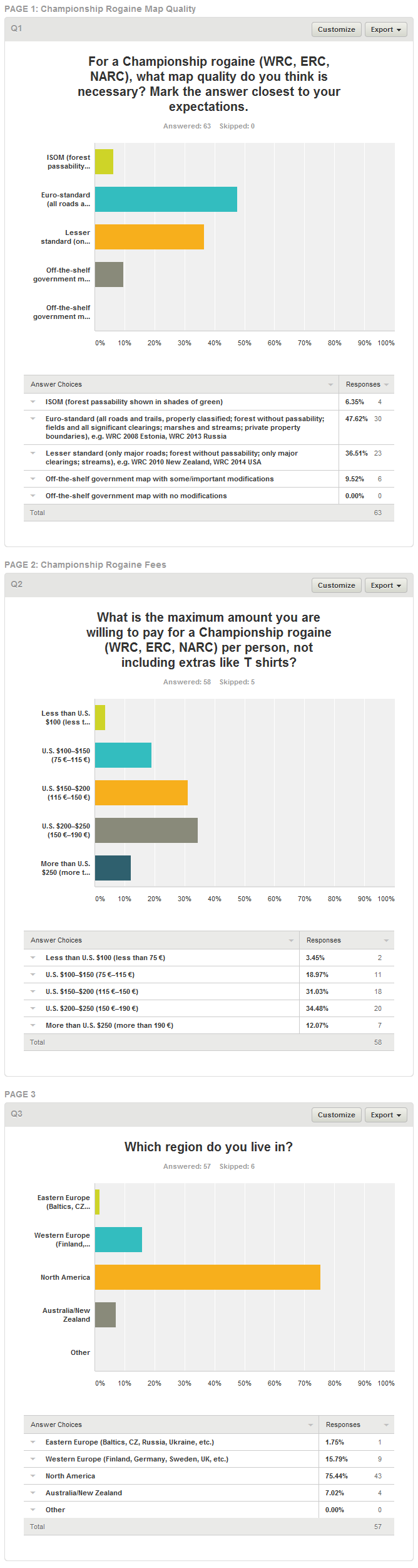
Sep 25, 2014 4:51 PM
#
From the thread above:
Nikolay: And no one else will be balking at that price increase ($80 -$100 per person) for World Championships.
T/D: This conclusion is inconsistent with the results of the survey.
Looks like this conclusion is very consistent with the results of the survey. 77.58% of your survey would be willing to pay $80+ extra for a championships rogaine.
Sep 25, 2014 5:04 PM
#
Price increase vs. price. So the $125 for this year's + $80 to improve the map would be $205 and is too much for over half of the respondents, who apparently don't do any road running, bike racing, triathlons, or movie going. I'm not sure if you got a T-shirt that could bump it back down under $200 and reclaim some of them.
Sep 25, 2014 5:15 PM
#
Nikolay, what data are you looking at? I can only refer you to the data above. According to the survey, THE MAJORITY—53.5%—of those who answered the question WILL be balking at a $80–$100 increase in price (to $205–$225).
This number of respondents (31) is 49% of those who took the survey (five didn't answer this question). So I don't know how else to put it, but your conclusion above is inconsistent with the results of this particular survey.
This number of respondents (31) is 49% of those who took the survey (five didn't answer this question). So I don't know how else to put it, but your conclusion above is inconsistent with the results of this particular survey.
Sep 25, 2014 6:24 PM
#
You are threading on a wire here.
From the survey question you ask for a maximum, but you give a range as an answer. So it is open for interpretation, but since the question asks for a maximum amount to pay and for the person to select this range he should be comfortable with that upper bound to choose the range, I'll use the upper number. (and it proves my claim better :-)
As for the $80+, sure I did embellish those 5 bucks, lets go with $75 extra per person.
So with that change the 77.58% of surveyed would be willing to pay $75 extra dollars for a championships rogaine.
Sep 25, 2014 9:30 PM
#
hey guys, guys, guys: who cares about 'em $200+ events. There is an event in a few hours that we've paid just a Jackson and a Lincoln (20 + 5 = 25), and extra $2 for the SI card rental. Gas to drive the 200 miles is gonna be the bigger expense. Beer at the local craft brewery will be a enjoyable expense. And the map {unfortunately} is going to have all forest roads mapped... dang... I was hoping for some unexpected surprises requiring some top-of-the-head improvisation and good guessing, but not to be... And yes, trees will be transparent.
Sep 25, 2014 10:03 PM
#
If I multiply 25 by 24 and divide by 3, I get 200, no?
What is your point?
Are you trying to say that events should be shorter?
Are you trying to say that organizers of longer events should provide them at the same price as organizers of shorter events and eat the loss just because they love you so much?
Are you trying to say that those who participate in shorter events that don't cost much are somehow smarter than those who fritter away their wantonly earned money on beating themselves up?
Seriously, the ridiculousness of some points of view in this community never ceases to amaze me. Nor its inattention to hard data. Nor the irrationality of expecting people to do certain things just because.
Sep 25, 2014 11:46 PM
#
... was just putting some humor here... nothing scientific... we will be taking it easy and having fun this Saturday.
Sep 25, 2014 11:56 PM
#
Quote of the day:
“This planet has a problem, which was this: most of the people living on it were unhappy for pretty much of the time. Many solutions were suggested for this problem, but most of these were largely concerned with the movement of small green pieces of paper, which was odd because on the whole it wasn't the small green pieces of paper that were unhappy.”
“This planet has a problem, which was this: most of the people living on it were unhappy for pretty much of the time. Many solutions were suggested for this problem, but most of these were largely concerned with the movement of small green pieces of paper, which was odd because on the whole it wasn't the small green pieces of paper that were unhappy.”
Sep 28, 2014 1:08 AM
#
Read this thread. Still have no idea why people whine about the map.
I understand complaints about a misplaced control, but what was difficult about those that had been where indicated? Yeah, not knowing about some faster routes introduces some element of randomness, otherwise known as sense of adventure...
I understand complaints about a misplaced control, but what was difficult about those that had been where indicated? Yeah, not knowing about some faster routes introduces some element of randomness, otherwise known as sense of adventure...
Sep 28, 2014 1:33 AM
#
Ignorance is a bliss; there is no adventure in abbreviation and definition of the ROGAINE, World Championship is competition in navigation, not adventure, there are other races for the latest, we did not sign up for that, and would not sign up for that.
Sep 28, 2014 1:39 AM
#
Agree with Greg. Sure there is a time and place for 'sense of adventure' -- like un-timed training runs: "Hey we've got lots of time, let's take the short cut." But not at a World Championships!
This discussion thread is closed.