Discussion: A knoll
in: PG; PG > 2014-08-19
Aug 19, 2014 11:29 PM
#
may have been an appropriate description for 79. Looking at the map, you will notice that the circle is centered near the end of the spur, and presumably it went up again a bit at the end, so that the course setter felt it looked more knoll-like than spur-like. I don't really know, since we didn't find the control, though the GPS track came considerably closer to the center of that circle than it did to several others where we actually found the control flag. I've personally never quite understood the reason for using the A vs THE notation in the first place, since if the contours don't quite represent the appearance in the general vicinity of a control location, it would make more sense to me to re-draft the contours a bit so that the A feature becomes a THE feature. Nowadays it is so easy in OCAD--a couple of decades back when I was using photocopied USGS quads for setting rogaines it was more of an undertaking, but it was usually possible to do some literal cut-and-paste by finding a suitable chunk of map to cut out with scissors and glue over the original bit that had offended me in order to get the right shape.
I was wondering a bit on the plane flight home about whether the initial choice of control locations for at least most of the controls had perhaps been done directly with the USGS map, and then simply transferred over to the specially drafted map after the fact, possibly via GPS location, without maybe paying enough attention to whether switching from one contour interval to another via a DEM might have introduced a distortion in the appearance on the map. I could certainly believe that this might have accounted for some of the positional disparities, such as the non-appearance of the reentrant for 71 on the map. In other places however, such as 84, it seemed as if the flag was simply positioned just a little higher than where the intended reentrant actually ended, but unfortunately with enough deadfall in the area so that it was easy to waste several minutes without catching view of the flag from the place which I would have characterized as the upper end of the reentrant.
I guess I feel that with as much rather open woods as existed in the area, it didn't make a lot of sense to put any of the control flags right in the middle of extra-thick patches. My own rule of thumb is that I would plan to throw away probably 1/4 to 1/3 of the initial control sites on the first draft plan for a rogaine course, just because when visited in the terrain the map was locally not so great, or the area was simply very overgrown or trashy. I suspect that more effort was made in this case to just go ahead with Plan A regardless (perhaps because of needing to get approval of the course from the Forest Service in advance and then having major administrative hassles to deviate from the original document?)
In any case, I enjoyed our trip out quite a lot, and just hope that they will eventually (and soon!) be able to sort out the SI stuff satisfactorily. In all other respects, despite the grumblings about some aspects, I thought that things got done on the whole as well as or better than at many of the WRC's that I have been to in the past.
I was very pleased to see that with similar expectations on distance to cover that we had chosen such a nearly identical route to that which you and Sandy had picked! I was a little more disappointed that we didn't execute it quite as well in the terrain. I think much of the later speed difference was just poor hydration management on my part, since we slowed down a lot relative to you after daybreak on Sunday when I couldn't any longer keep up with Mary and we had to drop 102, 69 and 90 from our schedule to get back on time. We must not have been terribly far apart (but probably a bit behind you) at sunrise, since we also did 94 in the dark and 72 by daylight. Sandy obviously meters her effort out a little better!
Aug 20, 2014 1:49 AM
#
PG:
Well, first things first, as legible as I thought the map was, I still misread what was mapped at 79. Thought it was a little knoll just floating outside a fairly straight contour line. So therefore "a knoll" indicated to me a second knoll, not on the map, which they had chosen to use for a control. Made no sense. Now it does.
We got lucky at 79, but also some good O' "feel" helped out. Bearing and pace from the road heading NNW. Both were difficult given the very trashy woods, but I'm usually pretty good at adjusting. Partway there our route started being on the slope above the reentrant, as expected and hoped. Woods were even worse. Ran into two teams searching, I can't remember if anything was said but the vibes were that they had been there a while.
I then remember saying to Sandy that I thought we still needed to go a little farther. Went about another 100 meters. Stopped, saw nothing with even the hint of a knoll. I then remember saying to Sandy that there was no way of knowing exactly where we were, and that we could blow off a lot of time there and still not find it, given the woods, and that maybe we should just move on.
And just then she pointed forward and a bit to our right and said something like "it looks flat over there, we should check it". And we turned and went maybe 20 or 30 meters in that direction and got a glimpse of orange and white, and unreal, it was the control. The reflector was both behind the tree and wrapped up in the control and not helping at all. Not a knoll in sight.
Punched and moved on, feeling very very lucky, but also just a bit skillful too… :-)
I wonder if maybe you're right about the control placement, that the spots were picked first from the map, and then just used without any changes. Some were almost absurdly easy, others absurdly unpleasant, others absurdly indistinct. And of course some were just fine. :-)
As is true for you, I have a lot of good memories and am very glad I went, and glad to have a good partner. Sandy was certainly suffering, but she kept plugging away. I'm pretty sure it helped that I carried her pack for the last few hours. If I had had a brain, I would have carried it a lot sooner in the course and a lot more, as it helped even us out.
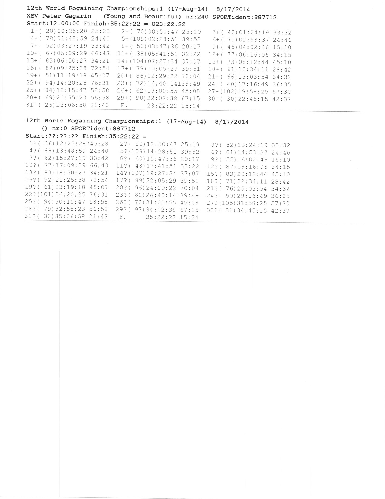
Regarding our relative positions late in the course, here is a copy of my splits. Maybe you were lucky to get a copy of yours? You were certainly moving well when we saw you early on, and I'm guessing it was our good luck at 79 that was the difference overall.
We got lucky at 79, but also some good O' "feel" helped out. Bearing and pace from the road heading NNW. Both were difficult given the very trashy woods, but I'm usually pretty good at adjusting. Partway there our route started being on the slope above the reentrant, as expected and hoped. Woods were even worse. Ran into two teams searching, I can't remember if anything was said but the vibes were that they had been there a while.
I then remember saying to Sandy that I thought we still needed to go a little farther. Went about another 100 meters. Stopped, saw nothing with even the hint of a knoll. I then remember saying to Sandy that there was no way of knowing exactly where we were, and that we could blow off a lot of time there and still not find it, given the woods, and that maybe we should just move on.
And just then she pointed forward and a bit to our right and said something like "it looks flat over there, we should check it". And we turned and went maybe 20 or 30 meters in that direction and got a glimpse of orange and white, and unreal, it was the control. The reflector was both behind the tree and wrapped up in the control and not helping at all. Not a knoll in sight.
Punched and moved on, feeling very very lucky, but also just a bit skillful too… :-)
I wonder if maybe you're right about the control placement, that the spots were picked first from the map, and then just used without any changes. Some were almost absurdly easy, others absurdly unpleasant, others absurdly indistinct. And of course some were just fine. :-)
As is true for you, I have a lot of good memories and am very glad I went, and glad to have a good partner. Sandy was certainly suffering, but she kept plugging away. I'm pretty sure it helped that I carried her pack for the last few hours. If I had had a brain, I would have carried it a lot sooner in the course and a lot more, as it helped even us out.
Regarding our relative positions late in the course, here is a copy of my splits. Maybe you were lucky to get a copy of yours? You were certainly moving well when we saw you early on, and I'm guessing it was our good luck at 79 that was the difference overall.
This discussion thread is closed.