Discussion: Course design - Frequent Cat Middle M21
in: Orienteering; General
Jun 22, 2016 10:34 PM
#
rm:
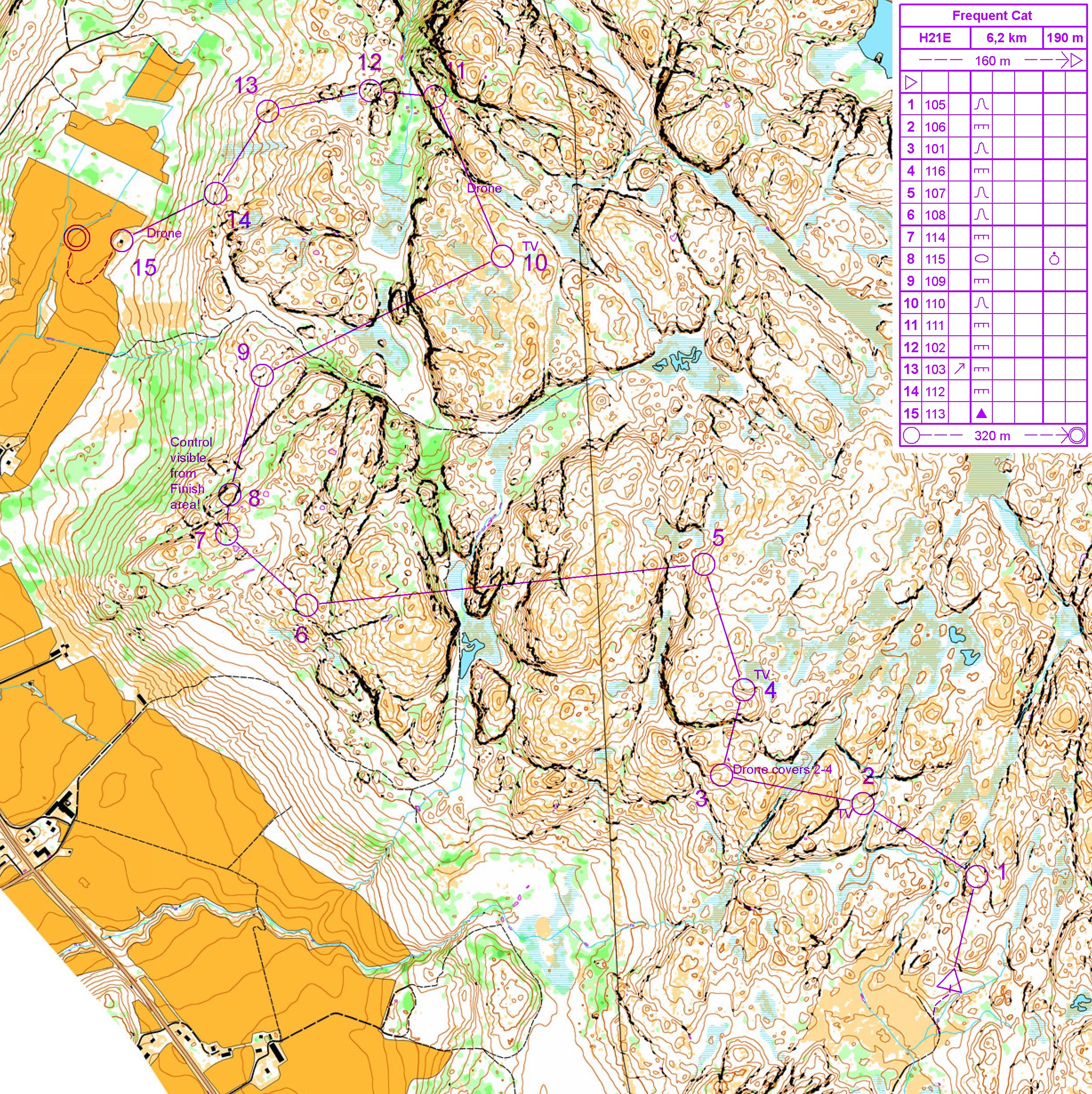
Below is a submission of a Middle M21 (H21) course on the autogenerated WOC 2016 Tanum map. Let us know your thoughts on this course, and on its media and spectator features.
Jun 23, 2016 12:44 AM
#
I'm puzzled as to why this course has only 15 controls and the previous one had only 14 - I'd certainly be tempted to have more shorter legs mixed in for a higher control count overall (at least 20) if I had time and energy for armchair course setting just now.
Jun 23, 2016 4:09 AM
#
rm:
The course designer included the following comments with the submission:
"I have used cameras in a few places, drones where the forest is open (this is typically open pine on the hilltops when I've competed in neighboring terrain), and I've placed a couple of controls so that one of them will be visible from the Finish area. :-)
I've tried to make a couple of longer legs with at least some route choices available."
Jun 23, 2016 9:31 PM
#
rm:
I like the variety in navigation, the technical difficulty, the variety in leg length, and some interesting route choices. The high control visible from the finish is an interesting alternative to the spectator leg through the finish field. A good spread of TV controls and nice spots for drones to follow leaders (if allowed) or watch some navigation mid control. Will the TV control at 2 give away the location too much? Is 11 possibly a bit easy, along a long ridge that has a few flat spots to aid judging where one is along the ridge? 4 isn't so technical, but has some short route choice which makes it worthwhile. At first I was going to suggest dropping 12, but now I think it makes for some control picking pressure late in the course. The downhill diagonal to 14 challenges one to run faster but accurately with big consequences for an error late in the course when tired. A real opportunity to blow it late in the course, or gain several seconds over someone too timid.
The remote start is probably good for logistics (away from other stuff), fairness (away from loudspeakers announcing early results), and use of terrain. The start location relative to the pre-start field keeps people from seeing competitors on their course, without an excessively long run.
The remote start is probably good for logistics (away from other stuff), fairness (away from loudspeakers announcing early results), and use of terrain. The start location relative to the pre-start field keeps people from seeing competitors on their course, without an excessively long run.
Jun 24, 2016 3:16 AM
#
AZ:
I agree with Jim - some nice variations in this course, and a decent layout for logistics and spectating. Still, the first five legs have four very similar lengths and so I think even more variations - in tempo especially - would improve the course. Like JT says, perhaps more controls would help too to make more short legs...
Start - I assume it is easy enough to drive in the start gear / TV stuff to that location (too lazy to check the bigger map ;-). I would also consider starting from a high point and having a high-speed first leg (or two) with a downhill control. I think that would perhaps be a way to challenge runners to do the first leg at too high a speed and at least stop them reading too far ahead (in my opinion it would be a good chance to create a test of concentration & control at the highly emotional start of the race).
Leg 1 - slightly too easy, and not much by way of route choice. Even moving the start triangle slightly east would give an option to go to the right of the first hill.
Leg 2 - again I think it is a leg that could have more route choice with slight adjustment of the start/end points. I prefer at this WOC level to see control #2 taken from above to reduce its visibility - so might like to see the leg a tad shorter, with the control a little sooner, before the creek.
Leg 3 - I like the route choices.
Leg 4 - same here - though a little concerned about the dog leg created if people that #3 from the NE.
Leg 5 - I think this is too easy and not enough route choice. This has entered a fairly bland area and I wonder what is the best approach - to have a control in the bland area, to run through the bland area, or to avoid it all together. I think I might have tried to stay in the areas with higher contour complexity but would want to get into that area in person to decide. This could be a very good leg in the terrain.
Also, I wonder about what will happen when the fieldwork is done - will there be features (such as boulders, etc) that could be used rather than the simple re-entrant on the side of a steep slope. So, lots of potential for this to be a good leg. Just would need to check in the terrain, and on the final map.
Leg 6 - on this leg the trouble I have is that half way there is some of the highest complexity on the course and we run right past it. So I think a few controls should be in there. On the other hand, this leg is a great change of tempo and technique, and the leg is pretty cool with some great route choices
Leg 7 I find a bit disappointing - it seems just a bit too easy with the wide re-entrant helping too much. For us "normals" it is fine, but for WOC I think it might be more challenging to head north-ish (though that would probably introduce a dog-leg) or have some shorter legs downhill. I'm not sure
Leg 8 - I'm not convinced that control is visible from the finish. Neat idea if it is, and warrants the slightly too easy Control 7
Leg 9 - it is nice to have cross hill legs, but this control is in a "big" reentrant so too easy. Perhaps a change of terrain with some legs through the green to the east and uphill instead?
Leg 10 - nice. Crossing the terrain to a vague feature in new terrain type. Will depend how nasty those cliffs are. Nice change of pace too with a longer leg
Leg 11 - kind of the opposite of 10 ;) It is along the grain of the terrain and while there is route choice the technical difficulty is a bit too low I suspect
Leg 12 - might be interesting to take it a bit futher to the rocks under the line from 12-13 to increase the route choice interest of going left/right around the big hill
Leg 13 - I'm tempted to drop this one to make a more interesting cross-slope leg from the current #12 to #14.
Leg 14 - I would move further north to get away from the steep slope above the control. There I feel the slope change is too obvious at the current location, and moving north would add to the challenge
Leg 15 - I think a little too easy. I suspect the last runners will be driving along big elephant tracks. Probably nothing to be done at this point. But still I'd be tempted to use the knoll in the green or the rock under the 'n', where the pre-warning would be, and then to the current #15
Finish - lovely run through the crowd.
Overall I'd say this is a very challenging, fun course. Adding a bit more variation and tweaking control sites to add more route choices would be the next step.
Jun 24, 2016 7:30 AM
#
I agree with most of AZ's comments, i.e. a few of the controls are currently too easy, but I'm sure the final map will have a lot more small details allowing more interesting short legs.
The championship course will certainly have ~50% more controls, which means a bunch of short legs with significant direction change, and not the very similar starting controls on this course.
I like #6 due to the route choices available, it isn't easy to create legs in a Middle course in this terrain type that allows up to 30-60 second time differences between plausible route choices, i.e. as much as the typical spread across the podium finishers.
#11 is definitely along the grain, in this terrain type the only route choice is to decide when you cross the line of cliffs.
#12-13-14 would obviously be moved around when the final map have gotten all the boulders and block clusters mapped.
Jun 24, 2016 8:38 PM
#
ken:
Stats for the real course are now published in Bulletin 3: 6.3km, 310m climb, 25 controls, 35min estimated winning time.
Jun 28, 2016 6:38 AM
#
@ken, @jagge: WIth the designated Event area in the original place we guessed, ie. nearby "Tanum Maskinstation AB" and the new E6 bisecting the fields very close by, it really does seem like the course planners must have had a bit of a conundrum getting everyone into the finish, particularly if they also have an event area run-through!
There might be just enough terrain SW of E6 and E of the stadium to put a final loop there?
Another possibility is that the E6 is crossing the event area on pylons, in which case it would be easy to use both sides of the road for courses and/or event area pass-through, but from the contours that doesn't seem very likely. This means that the narrow strip of terrain above the E6 tunnel directly north of the industrial area must be where both courses pass from north to south of the road.
The traffic noise from having E6 directly adjoining the event area must be quite a significant problem as well, and I really cannot see any good way to have an arena pass-through. :-(
...
I've made a serious attempt to design a new H21 WOC course, with the required 6.3km length, 25 controls and 310 m climb, with the designated finish area, and that is really quite hard! I can get to approx 100 2.5 contours, i.e. 250 m climb, but the full 310 m means that the course has to go across the steepest hills all the way, with no optimal route choice that contours around.
Jun 28, 2016 6:33 PM
#
Leg 6 is really good. Rest of the legs are not same quality.
So what is the difference, why it is so much better? The answer is route choice alternatives. If you look at the 5 first legs, those are just fine but is there really any other options than going just straight? And if we look at the leg 6 carefully we may find out going almost straight isn't that bad option for that leg either, just little left and then by the lake back to straight line. Fast bare rock most of the time, just one steep climb at halfway. With left around route you save 10 contours (25 meters) but route is ~225 m longer. That's one minute or running, in that time you climb plenty of meters.
This illustrates pretty well how serious an obstacle needs to be to get elites sway from the straight line. And making them do that is essential, not only for having route choice challenges but also to force athletes to make turns not only at controls (marked with flag) but also along a route choice and make them run other directions than just marked to map with a purple line, that's easy bearing running, just no even need to take the bearing because it is already in map (align compass needle with north line and look where purple line points at). Everything becomes more complicated and challenging, even running to correct direction if you need to leave the straight line. Here the main obstacles planner can play with are climb and big cliffs, those should be used to make other alternatives than just straight line tempting enough to make sure "always straight" strategy is not the winning strategy. The biggest problem with this course is it does not use these obstacles well enough, legs are nice but always straight type of legs, all of them.
Jun 28, 2016 6:57 PM
#
rm:
+1 to Jagge's comments about forcing people off the straight line; it's definitely an extra challenge to navigation.
Jul 1, 2016 1:37 AM
#
rm:
The designer has submitted a second version:
"This one has the right number of controls, the correct length and the designated (WOC Bulletin 3) event area, with the new E6 highway drawn in from the aerial photos.
In order to get close to the the specified 310 m of climb I had to place all the controls in the steepest areas, and the final run-in pretty much has to pass over the tunnel like I do here. In fact, I'd be very surprised if the real course doesn't have a part that looks quite similar to my 16-25, i.e. the last third of the controls.
If they have a event area run-through then the final loop probably has to be up to the east, and it will be fairly short due to the same highway which bisects the most interesting part of the terrain. :-(
BTW, in order to have the same start for the women's 5.2 km the real start probably has to be close to the finish area, something that would also make it easier to achieve sufficient climb but harder to make all the legs interesting and/or significant in some other way.
I've suggested suitable areas for TV cameras, a drone operator on the slabs and a TV camera runner near the end.
I do find it problematical to get significant route choice legs here, with 25 controls I end up with a lot of intermediate/short legs. :-("
https://flic.kr/p/Jydn78
This discussion thread is closed.