Discussion: how to map a fissure (crack) on the ground
in: Orienteering; General
Apr 26, 2018 2:53 PM
#
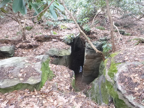
not a pit.
more like a hole on the ground bounded by two facing rock facades
more like a hole on the ground bounded by two facing rock facades
Apr 26, 2018 6:36 PM
#
looks to me it is about 6-8 m long
the terrain has plenty of fissures that start from flat ground and develop in quasi-canyons, as seen here
the terrain has plenty of fissures that start from flat ground and develop in quasi-canyons, as seen here
Apr 26, 2018 10:16 PM
#
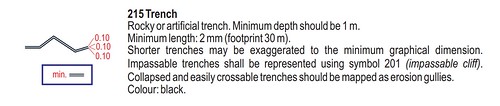
Exagerating to 4 times its length with the minimum trench symbol size? I would use the pit symbol.
Apr 27, 2018 1:19 AM
#
Petr:
2017 symbol set has a symbol 201-006 Impassable cliff, pit which perhaps could apply
Apr 27, 2018 2:17 AM
#
walk:
The video definitely looks like a trench and should be mapped as such. Notches into cliff walls maybe as caves.
Apr 27, 2018 3:36 AM
#
It was difficult to judge the scale of the photo, and I would originally have said a rocky pit. However, the video makes the scale clear. According to ISOM 2017 it's an impassable trench, which must be mapped as two impassable cliffs with a 0.4mm gap. This would mean a massive displacement of surrounding features, so what you have may not be usable.
The Czech mappers of the Bohemia 5 Days, and Rob Vincent (NSW Australia) who have mapped similar rock passages might be able to give you advice.
The Czech mappers of the Bohemia 5 Days, and Rob Vincent (NSW Australia) who have mapped similar rock passages might be able to give you advice.
Apr 27, 2018 8:54 AM
#
Now I've seen the video, it is clear that they are impassable crags, that end as a small fissure. It is important to show that they cannot be crossed, but one can pass down the gap between them. The sandstone areas of Czechia have many features like this.
Here are some examples from Euromeeting 2010: http://www.tur.cz/pekneprazdniny/2010/archiv/eurom...
Here are some examples from Euromeeting 2010: http://www.tur.cz/pekneprazdniny/2010/archiv/eurom...
Apr 27, 2018 10:50 AM
#
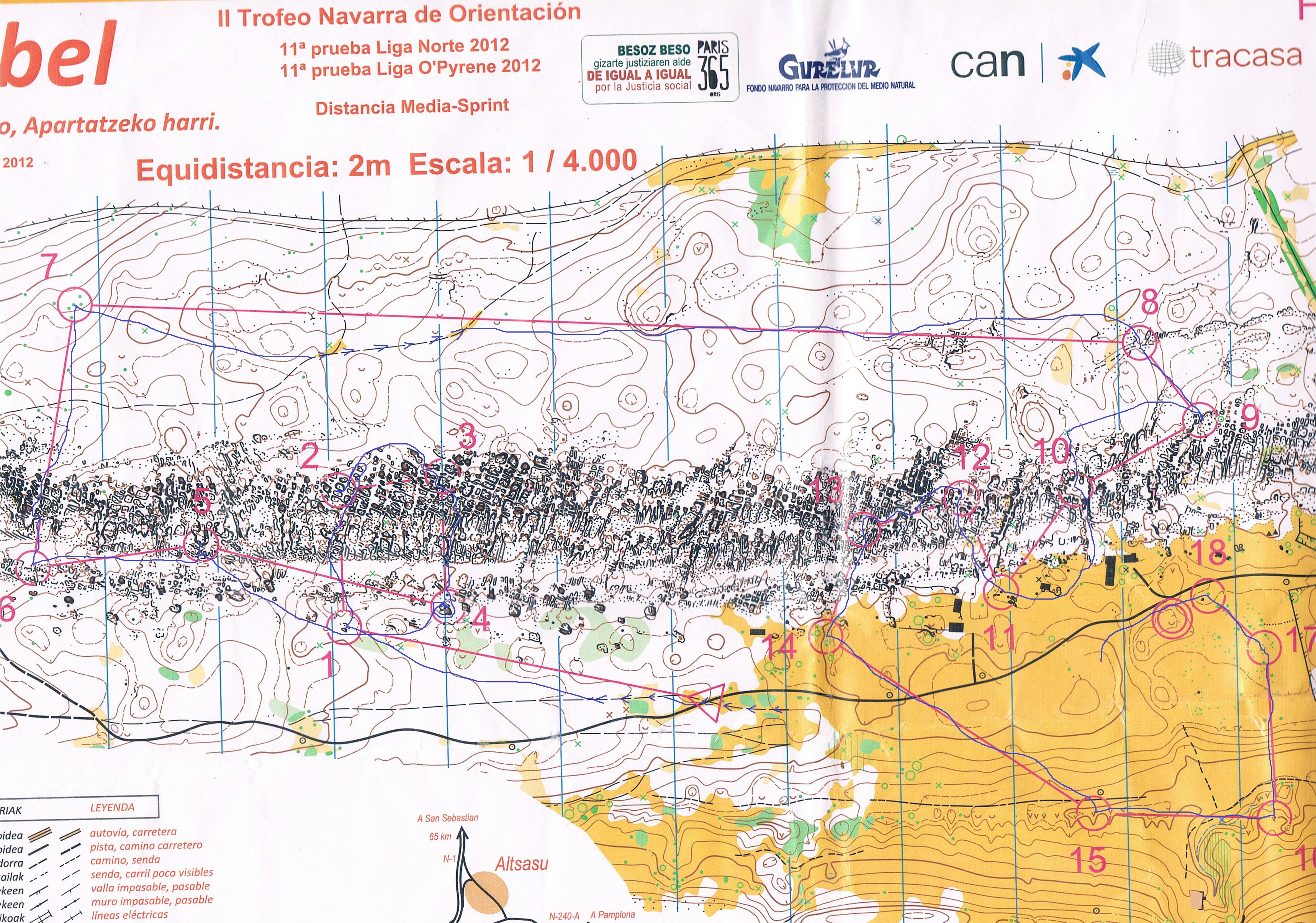
Perhaps the mapping style of Urbasa in northern Spain could help: http://www.nordesteorientacion.es/wp-content/uploa...
For the areas that you can go through or pass under, the mapper marked them in pink. There's an example south of leg 9-10.
For the areas that you can go through or pass under, the mapper marked them in pink. There's an example south of leg 9-10.
Apr 27, 2018 12:42 PM
#
How about mapping at 1:10k then? Oh sorry. I forgot. Thats not allowed.

Apr 27, 2018 1:12 PM
#
How about mapping at 1:10k then? Oh sorry. I forgot. Thats not allowed.
or 4000 like Spanish map
or 4000 like Spanish map
Apr 27, 2018 5:10 PM
#
According to current rules, ISOM 15K or ISSOM 4K are the only legal scales, with the only option to make pure enlargements.
It is however quite obvious that those sandstone terrains, as well as many cliffy coastal areas in Scandinavia and around the world would in fact be much better served by allowing ISOM 15K symbol sizes on an enlarged map, i.e. something like 1:10K or 1:12K. You will of course still enlarge this by 30 to 100% for older classes.
Personally I intend to encourage tests here in Norway, printing maps both ways and allowing elite and regular competitors to judge what they find best.
Apr 27, 2018 6:01 PM
#
rm:
The IOF way seems to be one map specification, and one scale, per discipline, more or less. Maybe we needa new discipline called Limestone Orienteering, and ISLOM.
Apr 28, 2018 7:12 AM
#
The same scale for middle and long. Middle to 10 would solve quite a few issues.
Apr 28, 2018 12:40 PM
#
@TheInvisibleLog: Middle & Long do have the exact same ISOM standard, except that Middle is usually enlarged from 15K to 10K: What we need to be able to map more detailed terrain is 15K symbols on a 10K map (or something similar).
This discussion thread is closed.