Discussion: 1970 Little Grassy Lake, Illinois
in: Orienteering; General
Sep 17, 2014 2:08 AM
#
I found this in Southern Illinois University at Carbondale. I reserved it to UIUC, borrowed it, and scanned it.
This seems to be the orienteering map for the first orienteering championship!
U.S. Individual Orienteering Champions (Classic)
I borrowed other maps. Perhaps I will post them later.
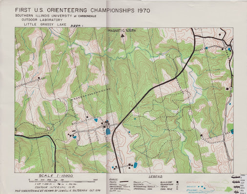
(The map is quite large. I need to scan the map two times to get the whole map. This explains the shadowy line in the middle.)
This seems to be the orienteering map for the first orienteering championship!
U.S. Individual Orienteering Champions (Classic)
I borrowed other maps. Perhaps I will post them later.
(The map is quite large. I need to scan the map two times to get the whole map. This explains the shadowy line in the middle.)
Sep 17, 2014 2:33 AM
#
Yes, that is what the maps were like. They were printed on a paper very close to the consistency of bristle board. (bristol board?)
Thanks for the link to the list of US Classic Champions. It brings up the question: do you think there is another sport where after 44 years of competitions all but three of the past men's elite champions are still active in the sport? All of the orienteering men's champions over the past 40 years are still active.
Orienteering: truly a lifetime sport.
Sep 17, 2014 12:20 PM
#
Up until a couple of years ago, three was approximately half of all men's elite champions...
Sep 17, 2014 12:59 PM
#
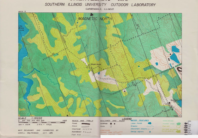
More scanned maps of the past that describe similar area. All maps were drawn between 1970 and 1972. Perhaps they will be good for reference in the future. If I have time, I may even digitize them to make them as OCAD and ISOM compatible as possible.


Sep 18, 2014 6:15 AM
#
You are not a true orienteer unless you save every one of your maps from every national, state or club competition. You are truly hardcore if you also save the training maps.
Sep 18, 2014 10:48 PM
#
I must be super hardcore recently on dreaming of orienteering :)
I think I just post these for nostalgic purposes.
Let me put some references here around AttackPoint that talks about this legendary map. I learned about these maps from these posts.
Comment about "Touch of Nature" (2010)
Orienteering in Memphis? (2009)
I think the map "Touch of Nature" refers to the 1970 map posted above.
Sep 19, 2014 12:21 AM
#
I can't find a copy of the ~1980 version of Touch of Nature. But, I found a copy of the 1983 Giant City State Park map. Giant City is across the road from Touch of Nature.
Pat Dunlavey, Dagrunn Urseth and Sigrid Kalbaek did the fieldwork at Giant City. The basemap was by Kart Tjaenst.
Pat Dunlavey, Dagrunn Urseth and Sigrid Kalbaek did the fieldwork at Giant City. The basemap was by Kart Tjaenst.
Sep 20, 2014 12:34 AM
#
Thank you for the ISOM map! The above map certainly overlaps with other maps shown above (e.g. the airstrip on the bottom right).
----------------------------------
Below is the last map that I can reserve from the SIU library. I think this map was used in the 1974 Championship.
Trail of Tears State Forest (1975)

----------------------------------
Below is the last map that I can reserve from the SIU library. I think this map was used in the 1974 Championship.
Trail of Tears State Forest (1975)
Sep 20, 2014 10:49 AM
#
I do remember orienteering on both the Trail of Tears and Giant City maps. Trail of Tears was an appropriate name because of the vicious hills. Not sure if that map was ever updated and pretty sure we used it for Training more than actual events by 1980. That 1970 map is a rarity! Thanks for posting.
Sep 21, 2014 1:01 AM
#
gordhun, regarding trhe 1970 map, commented: "Yes, that is what the maps were like. They were printed on a paper very close to the consistency of bristle board. (bristol board?) "
I don't know the actual name of the stock, but I was suprised to feel how heavy it was. When johnayuen showed the me the original, my first thought was that someone at some time had transferred the image for preservation's sake. I didn't think people would be running around in the woods carrying those things.
I don't know the actual name of the stock, but I was suprised to feel how heavy it was. When johnayuen showed the me the original, my first thought was that someone at some time had transferred the image for preservation's sake. I didn't think people would be running around in the woods carrying those things.
Sep 22, 2014 5:06 PM
#
I have copies of two of those maps. Ken Akerman gave them to me back in the early 70s, I think in trade for a couple of Ottawa maps. In those way-before-Internet days many of us collected maps from different countries. They were treated a bit like sports trading cards and lapel pins.
There was no universality of mapping standards in those days but through the 1970s the IOF and its mapping committee pulled off miracles getting the world to buy in to one standard.
There was no universality of mapping standards in those days but through the 1970s the IOF and its mapping committee pulled off miracles getting the world to buy in to one standard.
Sep 26, 2014 1:15 AM
#
Wangki:
Are these the maps I referee to you, via the IL state library system?
Are these the maps I referee to you, via the IL state library system?
This discussion thread is closed.