Training Log Archive: veinbusterIn the 7 days ending May 1, 2016:
| ||||||||||||||||||||||||||||||||||||||||||||||||||||||||||||||||||||||||||||||||||||||||||||
| « | » |
| » now | |||||||||||||||||
| Mo | Tu | We | Th | Fr | Sa | Su | ||||||||||||||
Sunday May 1, 2016 #
Note
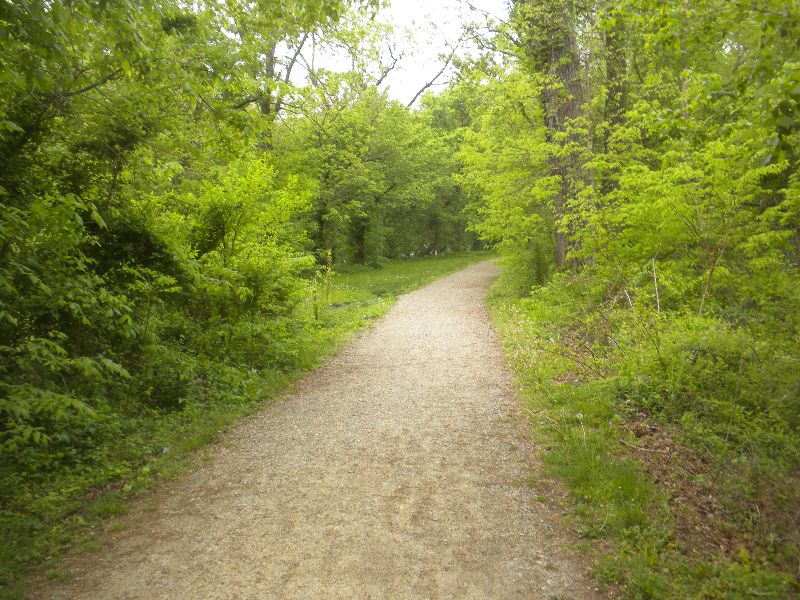
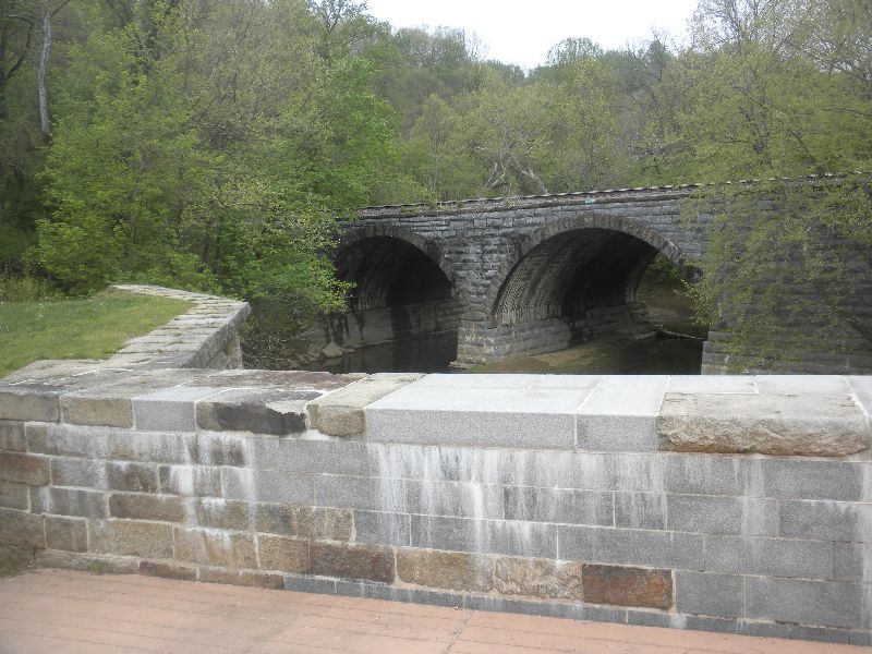
C&O Canal Trail
I road this yesterday from about mile 48 west to mile 66. It is a very well maintained trail along the north side of the Potomac River. Mile 0 east to Washington DC and mile a bunch at the Ohio border.
Lush greenery to start out.
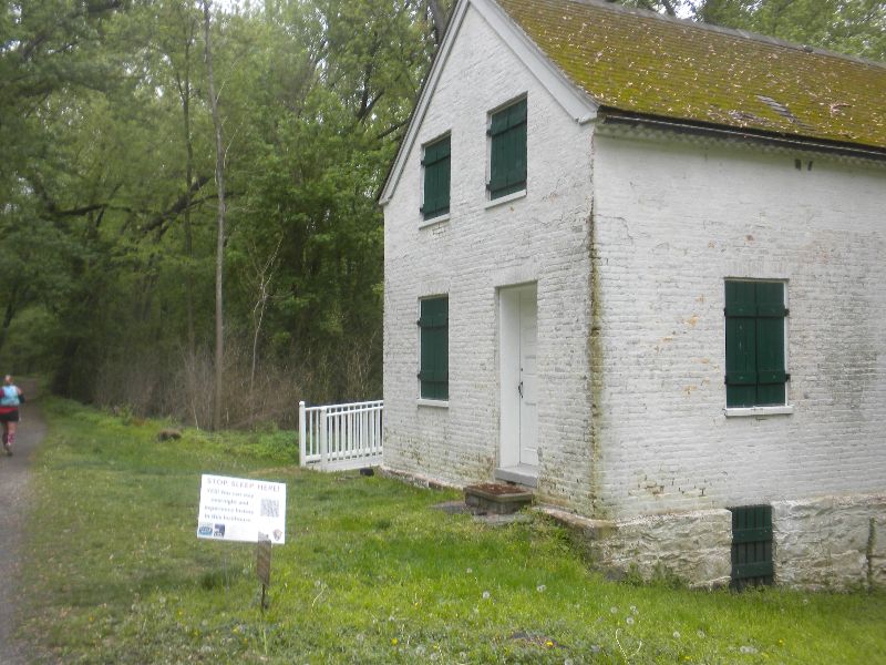
Old locks every few kilometers, some more overgrown that others. Some still have the houses that now provide a welcome and information about the trail
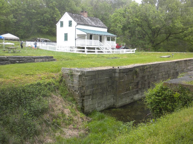
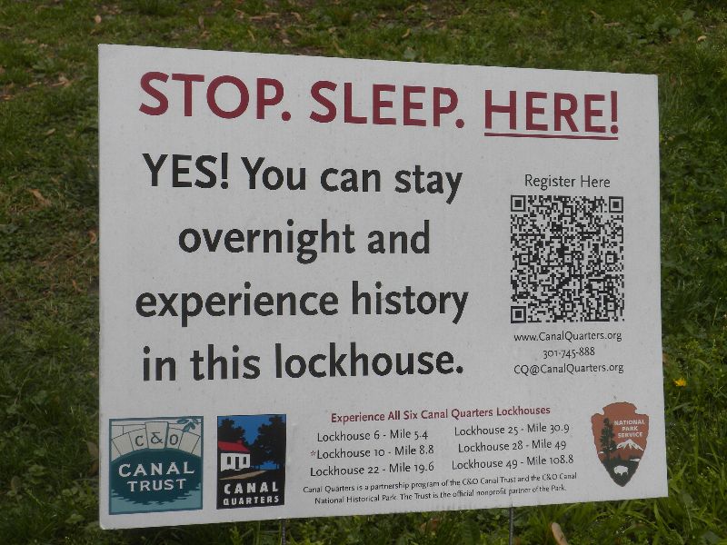
Some of them are available for overnight stays by travelers.
These, like many of the services are biased to parts of the trail closer to DC, but 28 and 49 are spaced for a leisurely tour of the trail.
There were also car/trailer camping sites and bike only camping sites. The bike site I went by was sized nicely for 5 or 6 strangers or a cozy group of about a dozen.
An active rail line ran beside the trail up to about mile 60 when it crossed over to the south side to run in West Virginia. This area at the Harpers Ferry crossing was the most congested area of the trail as it seemed to be a turn around point for people coming from each direction.
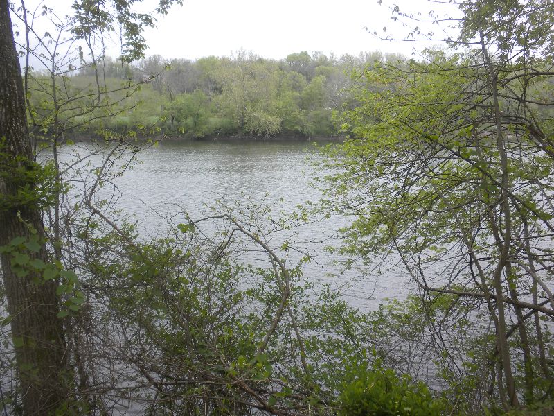
But the trail is really about riding along the river. There is very little elevation on this section of the trail so in most places the river looks pretty calm.
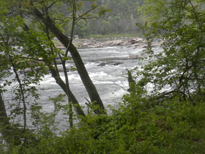
But even an elevation change of a couple of meters shows the volume of water that is moving
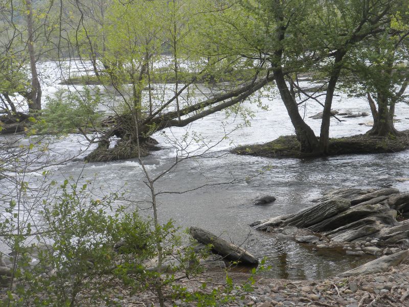
I found it interesting how big some stubborn trees were able to grow on a tiny piece of rock
The farther you get up the trail, the more likely it is that you will have to pick your own stopping point. There are old hand pumps in a few spots to fill up your water, but mostly you just pick a rock or a tree - I chose a try for a snack before heading back.

I road this yesterday from about mile 48 west to mile 66. It is a very well maintained trail along the north side of the Potomac River. Mile 0 east to Washington DC and mile a bunch at the Ohio border.
Lush greenery to start out.
Old locks every few kilometers, some more overgrown that others. Some still have the houses that now provide a welcome and information about the trail
Some of them are available for overnight stays by travelers.
These, like many of the services are biased to parts of the trail closer to DC, but 28 and 49 are spaced for a leisurely tour of the trail.
There were also car/trailer camping sites and bike only camping sites. The bike site I went by was sized nicely for 5 or 6 strangers or a cozy group of about a dozen.
An active rail line ran beside the trail up to about mile 60 when it crossed over to the south side to run in West Virginia. This area at the Harpers Ferry crossing was the most congested area of the trail as it seemed to be a turn around point for people coming from each direction.
But the trail is really about riding along the river. There is very little elevation on this section of the trail so in most places the river looks pretty calm.
But even an elevation change of a couple of meters shows the volume of water that is moving
I found it interesting how big some stubborn trees were able to grow on a tiny piece of rock
The farther you get up the trail, the more likely it is that you will have to pick your own stopping point. There are old hand pumps in a few spots to fill up your water, but mostly you just pick a rock or a tree - I chose a try for a snack before heading back.
7 AM
flexibility 17:00 [1]
8 AM
weight training 41:00 [2]
Day 3 resistance bands and push ups
Saturday Apr 30, 2016 #
6 AM
flexibility 13:00 [1]
9 AM
Mountain bike (Vinnie) 3:19:12 59.67 km (3:20 / km) +37m 3:20 / km
ahr:139 max:154
I don't usually drive to a ride, but made an exception with a free Saturday that was forecast to be warm and rain free. 1 1/2 drive down the the C&O Canal to scout it out before taking Mrs.
I don't have a repair kit for any of the bikes I have left in PA so packed a snow board bag with a few tools and a patch kit. I added food and drink for two, just in case I had to pause for a long period, and since I had the big bag might as well try carrying enough for Mrs. if we went on a day trip. I also tossed in my hotspots and iPad, just in case something went wrong and I had to contact someone from a place my phone carrier didn't service. Not the best bag for riding with, but it did the job and had space to shed layers as it warmed.
Just as I was getting on the bike a 6 engine train came to the crossing to the river. Even after using it as a good opportunity to dig the camera out of the electronics bag in my pack I had a good wait. It was about a 5 minute long train. Start was at hwy 15 and the Potomac River.
The first 12 km had lots of services: porta potties, hand water pumps and even a couple places to sleep - more on that when I get photos loaded. After that services were much harder to find, but popped up once in a while. At 17km I met the lead pair of ultra runners within 15m of each other just shy of the 25 mile mark in their 100 mile run. They were followed by 3 solo men at about 1 minute intervals and then the first woman in 6th overall looking incredibly fresh. The next woman was about 1 1/2 km back and looked like she was about to die. It was a bit mind boggling to see so many people 25 miles into a run at 10am - at the time I didn't know how long the run was.
I thought I might turn around when I ran into the main body of runners, but they stayed pretty spread out. In about 50th overall I went by a guy about 75 years old. 10km back a guy running in flip flops and the first person with poles.
I decided to go upstream 30km or until 11am, whichever came first. Turns out they were a minute apart and I paused at 10:59 to take off a layer, remove my cap and change into fingerless gloves. I guzzled 1/3 of a carton of coffee CocoLibre (very tasty protein) and about half of my coconut water-water-eload-mio concoction and ate half of a Bonk Breaker. Then a couple of photos and 4 minutes later I got back on the bike to head back. As I started out I realized not a single runner had gone by while I was stopped.
Return was a bit quicker because I had taken all but one of the photos I was interested in outbound. At 2:45 into the ride and 1300 calories, my legs started to show the effort - about as expected on a traditional bike. This happened to be were I saw the first chance for some of the runners to drop out at a big road accessible aid station in Brunswick - about 40km into the run and about 2 hours behind the leaders.
The last 12 km didn't have many runners - the leaders were long gone. Just as I got back to the parking lot another train came by (I think the 5th during my ride) so I stopped at the crossing just before the engine got there. This was only 3 minutes long. I didn't start the clock after it went by, so the last of the 60km ride doesn't show. While it was nice to get the backpack off and get off the bike, my legs feel pretty good - like they've done their work for the day, but not over done.
Photos and trail description later today.
Food test:
Coffee CocoLibre - I might like this one a bit better than the chocolate, which I'm a big fan of
Honey Stinger Protein chews (raspberry) - really good for chews, with pea protein
SmashPack (tropical fruit) - a pocket fuel type package with the nutrition much less dense. 14gm of protein and 180 calories in a pack a bit bigger than a pocket fuel - but whey powder instead of nuts I'm allergic to. Very easy to get out of the package. I gobbled this pretty quick when I got back to the car.
Friday Apr 29, 2016 #
5 AM
flexibility 18:00 [1]
lazy stretches before calling the bank about an issue with my credit card - just to prove I'm not intimidated by possible fraud
3 PM
weight training 58:00 [2]
Day 2 free weights, pushups, abs
Thursday Apr 28, 2016 #
5 AM
flexibility 18:00 [1]
4 PM
Cardio intervals (Trainer - legs) 1:22:33 [4]
ahr:144 max:167 shoes: Gekko
Sufferfest: Blender
Lower heart rate and higher power than when I last did this a few weeks ago.
Power: avg-185, max-664
Lower heart rate and higher power than when I last did this a few weeks ago.
Power: avg-185, max-664
Wednesday Apr 27, 2016 #
6 AM
flexibility 16:00 [1]
4 PM
weight training 56:00 [2]
Day 1 free weights
forced inside when tomorrow's rain started as I left the office
forced inside when tomorrow's rain started as I left the office
Tuesday Apr 26, 2016 #
5 AM
flexibility 14:00 [1]
Monday Apr 25, 2016 #
5 AM
flexibility 14:00 [1]
6 AM
weight training 42:00 [2]
Day 3 soloflex
3 PM
Mountain bike tempo (Vinnie) 1:17:00 [3] 27.6 km (2:47 / km) +137m 2:43 / km
ahr:132 max:153
Drove to PA early to pick up my Feb pay (long story). That did get me there ahead of commuter traffic so I headed out for a ride. I was hoping for a couple of hours but in my hurry to get on the road didn't grab a drink.
I thought even after being a bit under hydrated on the drive I could get 25km in. Once that ticked over I rode to Chipotle for a free dinner. And guzzled a bit of dink before riding to the apartment for dinner.
I thought even after being a bit under hydrated on the drive I could get 25km in. Once that ticked over I rode to Chipotle for a free dinner. And guzzled a bit of dink before riding to the apartment for dinner.