Training Log Archive: dbakkerIn the 7 days ending Sep 3, 2017:
| |||||||||||||||||||||||||||||||||||||||||||||||||||||||||||||||||||||||||||||||
| « | » |
| » now | ||||||||||
| Mo | Tu | We | Th | Fr | Sa | Su | |||||||
Sunday Sep 3, 2017 #
Note
Walked down and around the construction to get to UBCO. Great big new road being put-in right where we would walk, so that adds about 5 minutes of walking time getting to school. Hoping to get out for a run this evening if the smoke clears at all.
Saturday Sep 2, 2017 #
Note
It is really quite smokey and hot in Kelowna right now. We currently have no wifi in our appartment (we will get it by the 6th).
Friday Sep 1, 2017 #
Note
Can't believe it is already September.
Packing Day.
Packing Day.
Thursday Aug 31, 2017 #
Hiking 45:00 [1] 4.5 km (10:00 / km)
Walking around the beginner trail route up at Larch Hills flagging it and getting some more data. A couple of gorgeous 200-400 year old trees that we are diverting the trail around a little bit.
Wednesday Aug 30, 2017 #
Note
Silver Slope map finished. Named for the two Silver Mines further up the hill (not on the map, but could eventually be on a map expansion - but unlikely), and the fact that the entire map (except for maybe 1 single contour and about 3 formlines) is entirely one hillside. Map details over here. This was something of a speed map, about 3 hours tracing contours, roads, powerlines, etc. and then 6 hours of fieldwork. I think it would be a good idea to use this map instead of Park Hill or South Canoe for the fall series since those maps were already used this spring. Or maybe even swap out Coyote Park or Bastion/Sullivan to give those maps a rest for an entire year.
Map Image:
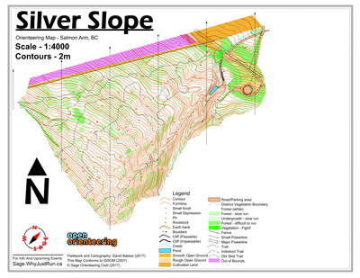
Map Image:
3 AM
Mapping 6:02:05 10.41 km (34:46 / km) +758m 25:29 / km
Mapping below the Silver Mine on Mount Ida. One of the nicest forests in Salmon Arm, about 60% legitimately white forest, 35% light green slash or light green, and only around 5% darker greens. Unfortunately, the map is steep, and relatively bland and featureless. When I finish up the drafting, borders, and what not I'll post the map tonight.
Tuesday Aug 29, 2017 #
Note
(rest day)
Spent all day today working on various map projects, and then the evening making jam (crab-apple jelly and plum jam).
Monday Aug 28, 2017 #
11 AM
Biking 54:32 [1] 9.22 km (5:55 / km) +165m 5:26 / km
Easy ride up/down logging roads along Wilson Creek above Roseberry with Lillian and Dad.