Training Log Archive: TheInvisibleLogIn the 1 days ending Sep 24, 2016:
| ||||||||||||||||||||||||||||||||||||||||
| « | » |
| » now | ||||
| Sa |
Saturday Sep 24, 2016 #
2 PM
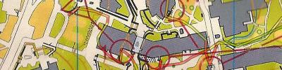
Real Orienteering race (Griffith Uni) 18:05 [5] *** 2.35 km (7:42 / km)
spiked:14/17c shoes: ASIC Kayano green/white
Oz Sprint Champs.
Three route choice errors early in the course. This is partly due to my lack of spring practice. I was in a panic early on. Wrong route to 1. Wrong rote to 3. Wrong exit from 4 to 5 (which the GPS didn't pick up). I seemed to find it hard to read the detail. Thats partly age. But it was also the map. The map reminded me of my first draft of the La Trobe Bendigo map. Everything was accurate... too accurate. My first La Trobe map was pretty much a tracing of the high resolution aerial photos. This resulted in quite a few stairs and paths being narrower than the mapping standard allowed. When Evan came back from the world uni champs in Spain he looked at the map and warned me I was repeating the problems with uni champs sprint map. The stairs in particular were too small. I redrew the map shrinking buildings to exaggerate spaces, stairs and paths. Today's map could have done with the same treatment. Sprint mapping is really tough. I remember I didn't even attend the first use of the La Trobe map at Easter as I was expecting the usual post sprint map dissatisfaction. Being controller for the next day gave me a perfect excuse. I appeared when the packing up was underway and heard no map criticisms. ;-)
Three route choice errors early in the course. This is partly due to my lack of spring practice. I was in a panic early on. Wrong route to 1. Wrong rote to 3. Wrong exit from 4 to 5 (which the GPS didn't pick up). I seemed to find it hard to read the detail. Thats partly age. But it was also the map. The map reminded me of my first draft of the La Trobe Bendigo map. Everything was accurate... too accurate. My first La Trobe map was pretty much a tracing of the high resolution aerial photos. This resulted in quite a few stairs and paths being narrower than the mapping standard allowed. When Evan came back from the world uni champs in Spain he looked at the map and warned me I was repeating the problems with uni champs sprint map. The stairs in particular were too small. I redrew the map shrinking buildings to exaggerate spaces, stairs and paths. Today's map could have done with the same treatment. Sprint mapping is really tough. I remember I didn't even attend the first use of the La Trobe map at Easter as I was expecting the usual post sprint map dissatisfaction. Being controller for the next day gave me a perfect excuse. I appeared when the packing up was underway and heard no map criticisms. ;-)