Training Log Archive: TheInvisibleLogIn the 7 days ending Jan 21, 2007:
| ||||||||||||||||||||||||||||||||||||||||||||||||||||||||||||||||||||||||||||||||||||||||||||
| « | » |
| » now | ||||||||||||||||
| Mo | Tu | We | Th | Fr | Sa | Su | |||||||||||||
Sunday Jan 21, 2007 #
Back, core and achilles 10:00 [0]
weight:80kg
MTB (Not O) warm up/down 10:00 [2] 3.5 km (2:51 / km)
Running long 1:26:35 [4] 16.9 km (5:07 / km) +160m 4:54 / km
shoes: New Balance Road shoes
Saturday Jan 20, 2007 #
Running 1:02:30 [3] 11.3 km (5:32 / km) +85m 5:20 / km
weight:80kg shoes: New Balance Road shoes
A gentle run in the rain. First run at 4 in the afternoon for a few months. Body is obviously more used to 6 am. Met two of the species Jogger Irregularis. Never seen either of them out on my 11k trail before. In fact, never seen anyone out there other than Julie. Had a chat to one. Said his last run was in November and it had been too hot since then. I told him he needed a spouse who woke for pre 6am runs. He didn't like that. It was pleasant to see good evidence that running more than once between November and late January helps with speed. I thought I was running slowly, but he receded quickly.
The other species encountered was a feral pest. Biker destructivus maximus. Rain brings out the bikers who want mud. Over the past 5 years they must have been as frustrated as white water kayakers round here. There is a grade 4 rapid on the Loddon River near Bridgewater, and a grade 3 I think near English Bridge on the Campaspe. Never seen either of these rapids in spete, just beleiving the local paddlers.
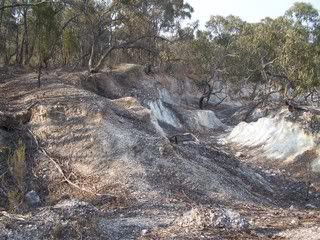
Had my own experience with mud, and it reminded me why the farmers who once worked this area referred to it as Sunday soil country. Too wet to work Saturday, Too dry Monday. You only get Sunday. The rain is very gentle. Only 8 mm over 6 hours. But it is enough to have the runnels down the tracks running well. The soil has been dry for so long it is hydrophobic. The ground is generally very hard still. The only place where the track has softened for running are occasional stretches of what passes for sand here, or an uphill section of very red sodic soil. Probably subsoil. It transforms quickly from concrete to sticky red glue. It happened this afternoon. The runners need a clean.
Friday Jan 19, 2007 #
Running 55:30 [3] 10.4 km (5:20 / km) +100m 5:06 / km
weight:78.6kg shoes: New Balance Road shoes
MTB (Not O) warm up/down 12 [2] 4.0 km (3 / km) +30m 3 / km
Back, core and achilles 10:00 [1]
Note
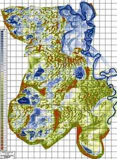
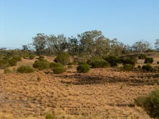
Is the area good for orienteering. Well, parts might be. There isn't much runnable sand dune country in Victoria. This is runnable. But its a long way from Melbourne. Obewan and I are more interested in organising a rogaine here. We had a great time at the Wilderness navigation challenge using a map with aerial vegetation detail and 10 metre contours. the contours were dodgy. The vegetation image was very useful in part of the map. This is what the red gum country looks like.
If we could get access to the LIDAR data and recent aerial digital photography, a very good rogaining map would be possible, with little time in the field. BTW, thats a 1km grid as far as I can work out.
More images at the photobucket site.
http://s132.photobucket.com/albums/q4/neil_barr/Ha...
Thursday Jan 18, 2007 #
MTB (Not O) 30:14 [2] 9.5 km (3:11 / km)
weight:79.2kg
Wednesday Jan 17, 2007 #
Back, core and achilles 10:00 [0]
weight:79.8kg (injured)
MTB (Not O) warm up/down 15:00 [1] 4.4 km (3:25 / km) +40m 3:16 / km
shoes: New Balance Road shoes
Running 45:00 [2] 7.7 km (5:51 / km) +40m 5:42 / km
shoes: New Balance Road shoes
After the easy run, I was 1.5 kilos lighter. I think it must be humid. And 24 degrees at 7am.
Tuesday Jan 16, 2007 #
Running 33:00 [3] 6.1 km (5:25 / km) +55m 5:11 / km
(injured) shoes: New Balance Road shoes
Monday Jan 15, 2007 #
MTB (Not O) 50:00 [3]
weight:78.6kg (injured)
Note
More tomorrow.