Training Log Archive: TheInvisibleLogIn the 7 days ending May 20, 2007:
| ||||||||||||||||||||||||||||||||||||||||||||||||||||||||||||||||||||||||||||||||||||||||||||
| « | » |
| » now | ||||||||||||||
| Mo | Tu | We | Th | Fr | Sa | Su | |||||||||||
Sunday May 20, 2007 #
Running (Technical training) 1:02:43 [3] ***** 6.56 km (9:34 / km) +325m 7:40 / km
spiked:8/12c shoes: Mizuno Wave Ascent II
Went for a technical run on Mt Korong. Julie gave me a course using controls I won't see on course 3. It took me up the Mount onto the west spur. Terrain unused for orienteering up to now. Well, its tough, its as technically complex as anywhere i have ever been on a map. I was totally bamboozled at some stage. But its also extremely scenic. Running the ridge at the top is beautiful. But while traversing across the slope, you don't have any time to appreciate the view if you want to stay in contact and on your feet! Studs necessary if its wet!
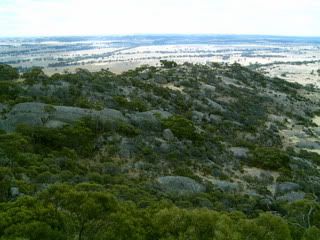
The greatest problem was getting through a maze of cliffs and passages on a spur running up the mountain. I missed the spot and was forced far up the hill. I'm sure you will all enjoy it!

Came back down onto the north spur, and it was quite easy navigation by comparison. Cockatoos had eaten some of the tapes. Julie hadn't put out some others, so I wandered looking for nothing. And in one spot the map was a vacant space where there was detail a plenty. We went back and finished the mapping. That made the chosen control site harder to describe, so it was shifted to the newly mapped cliff.
What a great day!
The greatest problem was getting through a maze of cliffs and passages on a spur running up the mountain. I missed the spot and was forced far up the hill. I'm sure you will all enjoy it!
Came back down onto the north spur, and it was quite easy navigation by comparison. Cockatoos had eaten some of the tapes. Julie hadn't put out some others, so I wandered looking for nothing. And in one spot the map was a vacant space where there was detail a plenty. We went back and finished the mapping. That made the chosen control site harder to describe, so it was shifted to the newly mapped cliff.
What a great day!
Back, core and achilles 15:00 [2]
MTB (Not O) (Gnarly single track) 1:03:46 [3] 17.06 km (3:44 / km)
Can't do long runs at the moment, so I tried to create a long run by riding steep single track on Browns Reef for an hour before going for a run. It doesn't really do the job. But it was a bit of fun anyway. I think today is all about making the most of where I live. One hour on some great single track out the back door, then an hour of navigation training on extremely complex granite half an hour up the road.
Saturday May 19, 2007 #
Real Orienteering race (Lyell Forest North) 49:05 [2] *** 8.01 km (6:08 / km) +170m 5:32 / km
spiked:7/11c shoes: Mizuno Wave Ascent II
How can one make 6 minutes of error on Lyell Forest Nth. I wouldn't have thought I'd ever manage this.
Thursday May 17, 2007 #
Back, core and achilles 20:00 [2]
MTB (Not O) hills 42:00 [3]
Discovered I'm no faster on a bike when doing this hill routine.
Wednesday May 16, 2007 #
MTB (Not O) 42:00 [3]
Learning to a avoid the red mud. Didn't have to clean the shower this morning... unlike yesterday.
Tuesday May 15, 2007 #
Back, core and achilles 15:00 [2]
weight:80kg
MTB (Not O) 38:00 [2]
Monday May 14, 2007 #
Back, core and achilles 20:00 [2]
weight:80.2kg
MTB (Not O) 35:00 [2]