Training Log Archive: TheInvisibleLogIn the 7 days ending Jul 29, 2007:
| ||||||||||||||||||||||||||||||||||||||||||||||||||||||||||||||||||
| « | » |
| » now | ||||||||||||
| Mo | Tu | We | Th | Fr | Sa | Su | |||||||||
Sunday Jul 29, 2007 #
Note
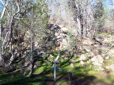
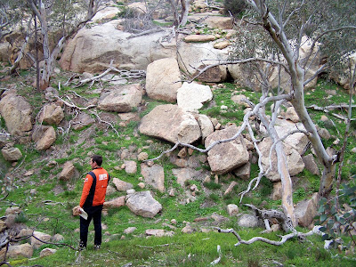
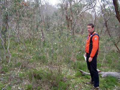
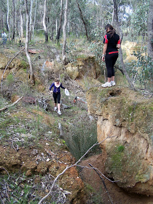
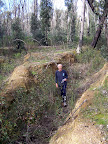
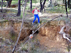
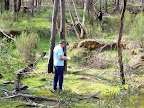
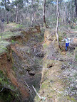
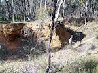
No running, but quite a few hours with Jymbo wandering terrain for 2009 Champs. Click on the photos to go to the full album. The terrain is good. Fast, at times restricted visibility. Bands of runnable light green across parts of the map mean you can't read much of the contour detail ahead. Good rock detail, some areas quite complex, others quite scattered and more difficult. Limited contour detail though. Should be at times technically more challenging than Sappa Bulga, if easier running. More of a Kooyoora style challenge.
Assembly and parking is a challenge also.
Click on the photo to get the full album.

Assembly and parking is a challenge also.
Click on the photo to get the full album.
Back, core and achilles 10:00 [1]
Saturday Jul 28, 2007 #
Real Orienteering (Black Jack Gully) 32:00 [3] 3.0 km (10:40 / km)
shoes: Columbia
A very different day of orienteering.
New map created by Ian Johnson and OCADed by myself.
In the light of a current thread elsewhere on this site.
1. The map had some errors. We didn't have the time to get it perfect.
2. The mapper is in his late 70s and did the field work for fun.
3. I made some errors in drawing the map because I didn't understand the field work notes.
4. The map was not to ISSOM or ISOM standard. It was 1:2000 scale, with rudimentary contour information, but lots of gold mining detail.
In other words, this was a very unprofessional event. But...
5. The 'competitors' had a lot of fun. Particularly some of the novices. The experienced orienteers learnt that this is a great sprint area that deserves good mapping. It has a good assembly area with all weather access. But it needs some work to control gorse. That might be another volunteer activity. It would cost way beyond our budget to involve professionals.
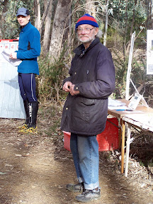
Here is Ian!
And some more.
New map created by Ian Johnson and OCADed by myself.
In the light of a current thread elsewhere on this site.
1. The map had some errors. We didn't have the time to get it perfect.
2. The mapper is in his late 70s and did the field work for fun.
3. I made some errors in drawing the map because I didn't understand the field work notes.
4. The map was not to ISSOM or ISOM standard. It was 1:2000 scale, with rudimentary contour information, but lots of gold mining detail.
In other words, this was a very unprofessional event. But...
5. The 'competitors' had a lot of fun. Particularly some of the novices. The experienced orienteers learnt that this is a great sprint area that deserves good mapping. It has a good assembly area with all weather access. But it needs some work to control gorse. That might be another volunteer activity. It would cost way beyond our budget to involve professionals.
Here is Ian!
And some more.
Friday Jul 27, 2007 #
Back, core and achilles 15:00 [1]
Running 35:00 [3]
shoes: Columbia
Welsford. A nondescript struggle of a run.
Note
Can't really help myself. Response to Tundra's comment, but don't want to clog up the thread.
We all would like to run perfect courses. When we organise we all aim to set perfect courses. I don't know anyone who plans for errors. But they happen sometimes despite best intentions and many many hours of work. It is how we competitors react to these errors that is my concern.
This is the scenario I see forming a coming major event in Australia. Think National Championships.
The national organisation has a schedule of events.
It falls to a certain state to take its turn organising. It takes many months to convince a club to take on the role of organising the event. Perhaps this club is exhausted by a good load of major events over the past 5 years. The club then has to find a 'volunteer' organiser. This may require a degree of encouragement and possibly subtle coercion. The agreement to organise will be grudging out of duty. There is no potential for financial enrichment.
At this stage it seems to me a delusion to suggest there is a 'customer' relationship between the annointed organiser and future competitors. The organiser is taking on a duty to a common community. Financial incentives play no part in influencing the behaviour of the organiser. There is a financial disincentive. There is no market. Allowing fellow orienteers to view themselves as 'customers' of this volunteer organiser sends the wrong message about relationships. The desirable message is something like this.
"I understand this event is organised by a volunteer. If things go wrong, I should treat that person as I would expect to be treated when I volunteer next year. My expectations are that the volunteer will do the best they can, but I will not belive perfection is inevitable".
The expectation of being a "customer" who is "king" or "always right" ha sthe potential to create conflict that will reduce the community spirit that is called on to find volunteers. It may become harder to find a volunteer next year. Relationships nurture the volunteer workforce. We should treasure those relationships and build our policy around maintaining them.
So from my perspective:
1. The volunteer is king
2. See #1.
Thursday Jul 26, 2007 #
Running 26:00 [3]
shoes: Columbia
All the time available for a run around Nagambie at dusk. I think this town wins an award for doing the least with the greatest potential for building a great walking and running track.
Wednesday Jul 25, 2007 #
Back, core and achilles 12:00 [1]
Running 37:00 [3]
shoes: Columbia
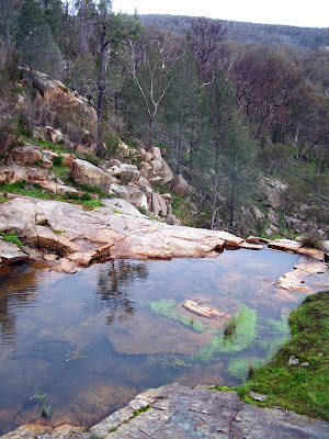
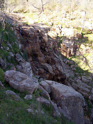
Spent the morning in Wangaratta for work. On the way home I drove across a neaby range and went for a short exploratory run. Learnt a fair bit more about the area. Its not all like this. Waterfalls are generally scenic. And steep.

Tuesday Jul 24, 2007 #
Back, core and achilles 15:00 [3]
Drove out into the Welsford forest for a lunchtime run. Deiscovered I had left running shoes at home. Played a couple of fiddle tunes then back to the desk. Looks like a run in the dark tonight.
Monday Jul 23, 2007 #
Back, core and achilles 15:00 [1]
Note
No run tonight. Played fiddle in a fiddle-banjo-guitar combo for a few hours. For the first time in a long time, fiddle felt good. The number of bum notes decreasing.