Training Log Archive: TheInvisibleLogIn the 7 days ending May 23, 2010:
| |||||||||||||||||||||||||||||||||||||||||||||||||||||||||||||||||||||||||||||||
| « | » |
| » now | |||||||||||
| Mo | Tu | We | Th | Fr | Sa | Su | ||||||||
Sunday May 23, 2010 #
Note
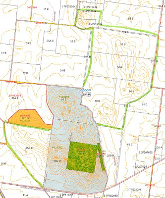
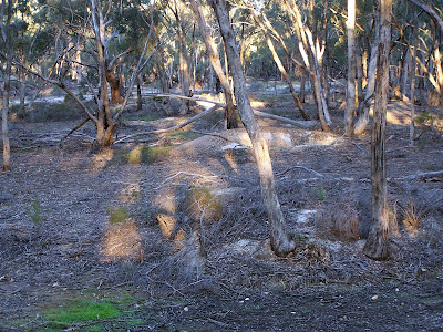
Mount Korong
Have noted a few loving comments in AP logs aboutthe Mt Korong terrain.
More to come. This shows the area to be considered inside the green line. We have photogrammetry for all this. The grey and yellow areas are public land. Yellow is currently leased.
Parts that could be mapped:
Yellow. Only a small add on, but a massive area of grey in the middle of it. Best for novice courses. Would be quite an incredible novice area.
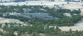
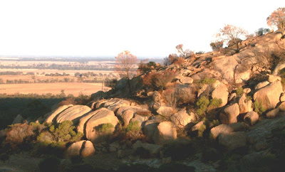
Grey: This includes most of the current map. The south of the peak is yet to be mapped. Some tough country including some significant cliffs, areas of green, and interesting terracing effects. the granite on the ridges is stepped, with cliffs between some of the terraces. It would make the area suitable for a long style course. See photo link below. Have made a small start to mapping this. See segment in album.
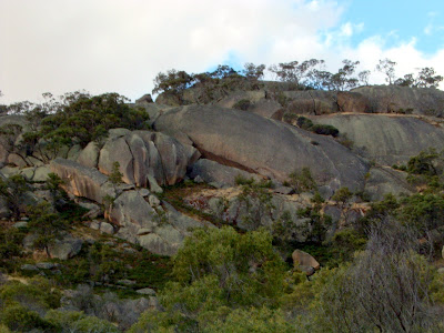
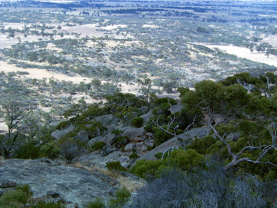
The north east. Significant area of granite on private land. A small area wa sused for the Aus Middle in 2006, forming the assembly area. Most is still unmapped. Change of owner means we need to renegotiate access. Very different terrain. Not too much steepness. Lots of smaller granite with some very rough areas scattered through faster running. Good access point from north. See photo link below including photogrammetry.
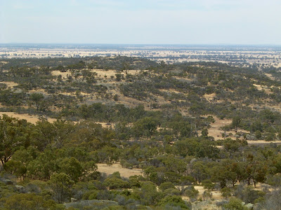
The west: Open paddocks with granite. Not sure we could get access. Conservation covenants etc.
The Mount Photogrammetry
The larger cliffs and terracing.
Great view means a bit of climb!
More photos inalbum link.
Now the north
Photogrammetry
Obviously more gentle
Smaller granite
Something to look forward to.
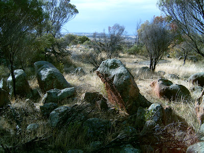
For good measure. stopped on the way home to take some photos of Glenablyn Historic Features Reserve. Potential for a mining terrain sprint map?
Have noted a few loving comments in AP logs aboutthe Mt Korong terrain.
More to come. This shows the area to be considered inside the green line. We have photogrammetry for all this. The grey and yellow areas are public land. Yellow is currently leased.
 |
| From Korong |
Parts that could be mapped:
Yellow. Only a small add on, but a massive area of grey in the middle of it. Best for novice courses. Would be quite an incredible novice area.
 |
| From Korong |
Grey: This includes most of the current map. The south of the peak is yet to be mapped. Some tough country including some significant cliffs, areas of green, and interesting terracing effects. the granite on the ridges is stepped, with cliffs between some of the terraces. It would make the area suitable for a long style course. See photo link below. Have made a small start to mapping this. See segment in album.
 |
| From Korong |
The north east. Significant area of granite on private land. A small area wa sused for the Aus Middle in 2006, forming the assembly area. Most is still unmapped. Change of owner means we need to renegotiate access. Very different terrain. Not too much steepness. Lots of smaller granite with some very rough areas scattered through faster running. Good access point from north. See photo link below including photogrammetry.
The west: Open paddocks with granite. Not sure we could get access. Conservation covenants etc.
 |
| From Korong |
The Mount Photogrammetry
 |
| From Korong |
The larger cliffs and terracing.
 |
| From Korong |
 |
| From Korong |
Great view means a bit of climb!
More photos inalbum link.
Now the north
 |
| From Little Mount |
Photogrammetry
 |
| From Little Mount |
Obviously more gentle
 |
| From Little Mount |
 |
| From Little Mount |
Smaller granite
Something to look forward to.
For good measure. stopped on the way home to take some photos of Glenablyn Historic Features Reserve. Potential for a mining terrain sprint map?
 |
| From Glenalbyn |
Running long 1:21:50 [3] 12.52 km (6:32 / km) +200m 6:03 / km
weight:78.6kg shoes: Saucony Xodus 9.5
Easy run mainly off tracks in Stumpy Gully. Followed ridge and escarpment lines. The map will now have four new watercourses, one new track and four new cairns. Not sure if I should log rock lugging. None of the cairns is where I really want one. That will take a wheelbarrow. I ran through the target zone and couldn't see a rock in any direction.
Saturday May 22, 2010 #
Real Orienteering race (Korong Spur) 1:09:48 [4] ***** 8.93 km (7:49 / km) +200m 7:02 / km
ahr:131 max:164 spiked:16/21c shoes: Nike Trail
A wonderful day on a wonderful map in magnificent terrain. I think Mt Korong is becoming my favourite bushland within striking distance of home. The day was notable for being Evans first course setting on granite. Mt Korong is a bit of a baptism by fire. He left too little time to scout controls before the day, so re-used control sites from the past 3 events. I calculated that I knew two thirds of the controls on the A course... or thought I did. Most of my errors were on controls i supposedly knew. Hubris effect! I didn't navigate but ran towards where I thought it would be on more than one occasion, and each time I came a cropper. I blew 5 controls of 21. I'll take responsibility for 4 of those. The fifth was placed a little off centre, as Evan underestimated how long it would take him to place 37 controls... 3 hours was a little too close for comfort. I'm happy he appears to have learnt a lesson about granite course setting. I look forward to his next courses when he knows how long it will take to do a good job. These ones were really well shaped and other than one control, everyone had a grand time out there. Thanks Ev.
Attendance was down- only 45. It will be interesting to determine the relative influence of distance from Melbourne, fear of granite and competing SS event on Sunday. I suspect the paint brush will keep me away from the SS tomorrow. I will scan the results to try and answer the question.
Impressive feat of the day. Two very novice orienteers completed a short hard course. Each had done only a couple of events before today. It took each of them a fair time, and I suspect they felt they were slow. I'll make sure they comprehend what an achievement this was. The control sites were mostly in common with last years Vic Champs and they were quite hard.
Note
And yes, RouteGadget is up, together with splits for those that did the double download.
Friday May 21, 2010 #
Back, core and achilles 10:00 [1]
weight:78.6kg
Running warm up/down 30:00 [2] 5.0 km (6:00 / km) +20m 5:53 / km
(injured) shoes: Nike Trail
Took it easy with many stops to massage my calf. I wanted to know if it would get better or improve with use, with an eye on Mt Korong tomorrow. It improved, so I guess I'll at least start a course. Which one. I really like the look of Long Hard...
Thursday May 20, 2010 #
Note
(injured)
Calf too sore. Hopefully better by saturday. Looking forward to running at Mt Korong so taking today easy.
Wednesday May 19, 2010 #
Back, core and achilles 10:00 [1]
weight:78.8kg
Running 38:00 [3] 6.87 km (5:32 / km) +30m 5:25 / km
shoes: Saucony Xodus 9.5
A circuit of Lakes Neangar and Tom Thumb. On the third pass an unexplainable pain in the left calf ended the session. It was more painful to keep running than accepting the ignominy of stopping.
Note
Intergenerational transfer?
Spent the night talking to Ilka about the role of organising the upcoming Sprint Champs, and in email contact over the night with Evan about the event he is organising at Mt Korong on Saturday. They will be good courses.
Spent the night talking to Ilka about the role of organising the upcoming Sprint Champs, and in email contact over the night with Evan about the event he is organising at Mt Korong on Saturday. They will be good courses.
Monday May 17, 2010 #
Note
Seems no one wants to put up NOL results. Given it was in essence a SL event, I can understand organisers might be recovering from the day. Perhaps NOL competitors might take it on themselves to publish results, official or otherwise?
Back, core and achilles 10:00 [1]
weight:79.2kg
Was slack about back exercises on the weekend. Back into them again as the back was stiffening up already. Must be a sign of advancing crockdom.
Running 30:17 [3] 5.4 km (5:36 / km) +20m 5:30 / km
shoes: Saucony Xodus 9.5
Lakes Neangar and Tom Thumb. Not an inspiring effort.