Training Log Archive: TheInvisibleLogIn the 7 days ending Jan 1, 2012:
| |||||||||||||||||||||||||||||||||||||||||||||||||||||||||||||||||||||||||||||||
| « | » |
| » now | ||||||||||||||
| Mo | Tu | We | Th | Fr | Sa | Su | |||||||||||
Sunday Jan 1, 2012 #
Walking 7:00:00 [3] 18.0 km (23:20 / km) +940m 18:30 / km
shoes: Innov-8
Good News: Max of about 20 degrees.
Bad News: Arrived at Tawonga Huts to discover glasses left back at Little Plain.
The West Ridge of Fainter South- looks like an interesting climb for the future.
 |
| From High Plains January 2012 |
Snow gum on Fainter Ridge.
 |
| From High Plains January 2012 |
Bogong Jack's Saddle
 |
| From High Plains January 2012 |
The Politically Correct Range
 |
| From High Plains January 2012 |
 |
| From High Plains January 2012 |
 |
| From High Plains January 2012 |
And of course the summit images.
 |
| From High Plains January 2012 |
 |
| From High Plains January 2012 |
 |
| From High Plains January 2012 |
Running 40:00 [3] 8.0 km (5:00 / km) +100m 4:42 / km
shoes: Innov-8
Scenery on the way.
 |
| From High Plains January 2012 |
Saturday Dec 31, 2011 #
Walking 3:00:00 [2] 8.5 km (21:11 / km) +340m 17:39 / km
shoes: Innov-8
 |
| From High Plains January 2012 |
Friday Dec 30, 2011 #
Running 43:02 [3] 6.9 km (6:14 / km) +40m 6:04 / km
shoes: Asics
Highlight of run: It appears a wild duck wants to take up residence at the Golden Square swimming pool. Not sure how it is going to cope with all the company it will have over the long weekend. I think the forecast coming up is 35 37 39 40.
Back, core and achilles 15:00 [1]
MTB (Not O) 39:30 [2]
MTB (Not O) 21:45 [3]
Thursday Dec 29, 2011 #
Running 37:04 [3] 5.57 km (6:39 / km) +85m 6:11 / km
shoes: Pretty blue mizuno trail shoes
Wednesday Dec 28, 2011 #
Back, core and achilles 15:00 [1]
MTB (Not O) 25:00 [2]
MTB (Not O) 25:28 [3]
Tuesday Dec 27, 2011 #
Walking 4:00:00 [3] 6.0 km (40:00 / km)
shoes: Pretty blue mizuno trail shoes
Granite reef across the river. First break on the second day.
 |
| From Lerderderg Gorge |
About the deepest part of the gorge.
 |
| From Lerderderg Gorge |
One of the numerous swimming holes, though water quality was a little dubious.
 |
| From Lerderderg Gorge |
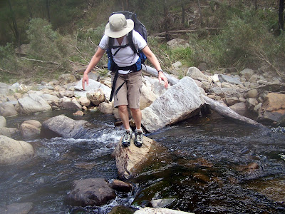
Lesson learnt: wet feet means dry bum.
 |
| From Lerderderg Gorge |
 |
| From Lerderderg Gorge |
More swimming holes.
 |
| From Lerderderg Gorge |
Approaching civilization again.. a ford.!
 |
| From Lerderderg Gorge |
Monday Dec 26, 2011 #
Walking 5:00:00 [3] 12.0 km (25:00 / km) +400m 21:26 / km
shoes: Pretty blue mizuno trail shoes
Started at the car park at the Bacchus Marsh end. Observed the fulsome evidence of Xmas boganisms, and after a quick lunch took to the trail.
After two kilometres climbed out of the gorge up the link track and then descended again into the gorge on the weir access road. One might wonder at the wisdom of climbing 350 metres out merely to begin a descent back down again. It was quicker than the alternative. From the diversion weir the walk was 'merely' a walk back down the river. The first potential camp sites were less than a kilometre downstream, but the day was yet young so we kept going to the next. By six we were about at the end of our capabilities, with the rough terrain and falls in the water and attempts to cut off distance by climbing over steep spurs. There are no short cuts and there is no point in keeping the feet dry. The camp site made up for the travails. We were in bed and sleeping soon after 8 pm despite the bountiful light available for reading.
Early scenery walking up the gorge.
 |
| From Lerderderg Gorge |
Steep climbing up the link spur track.
 |
| From Lerderderg Gorge |
 |
| From Lerderderg Gorge |
The scenery after the weir was pretty good. And we weren't tired yet.
 |
| From Lerderderg Gorge |
Futile attempts to keep feet dry led to the inevitable, including camera submersion.
 |
| From Lerderderg Gorge |
Camp for the night. Fog in the photo is after effects of camera submersion.
 |
| From Lerderderg Gorge |