Training Log Archive: TheInvisibleLogIn the 7 days ending Jun 26, 2016:
| |||||||||||||||||||||||||||||||||||||||||||||||||||||||||||||||||||||||||||||||
| « | » |
| » now | ||||||||||
| Mo | Tu | We | Th | Fr | Sa | Su | |||||||
Sunday Jun 26, 2016 #
1 PM
Running long 1:15:18 [3] 10.0 km (7:32 / km) +255m 6:41 / km
shoes: Kayana White/green
First bite at a return to long Sunday runs. 75 minutes was probably about it before foot issues. Will try 80 next week.
Off to Marne trig via diagonal track and return with a bit extra added.
Off to Marne trig via diagonal track and return with a bit extra added.
Saturday Jun 25, 2016 #
7 AM
Walking 2:30:00 [1] 10.0 km (15:00 / km)
A good walk ruined at -1 degrees. Water was freezing on the club heads.
1 PM
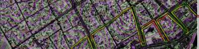
Real Orienteering race (Longlea) 37:12 [4] 5.76 km (6:27 / km) +75m 6:04 / km
shoes: Kayana White/green
Longlea. Its a quite flat and vague area. The navigation can be quite straightforward--- if you stay near the red line. All of this means this is an area where there is no excuse not to be running at your maximum sustainable pace for the whole course. No excuse to save yourself. And so it can be quite an exhausting area. My straight line kilometre rate (in an area where straight line kilometre rates mean something) was 6.38. Fifteen years ago I was running this area at close to 6, but never quite got there. So I suppose today's rate was pretty good for me. I have always felt confident in my navigation in this sort of area.

Thursday Jun 23, 2016 #
10 AM
Running 19:40 [2] 2.5 km (7:52 / km) +80m 6:47 / km
shoes: Kayana White/green
Run on Bullock Creek. Ran out of time and weather.
Wednesday Jun 22, 2016 #
5 PM
Running 43:51 [3] 6.45 km (6:48 / km) +240m 5:44 / km
shoes: Kayana White/green
Hard Mackenzie. It must be winter. Back on the most hilly combination I can create between here and town. Not much flat on this track. The 1m contour map says 250 metres climb. Garmin says 90. I know who I believe.
Monday Jun 20, 2016 #
6 PM
Rock climbing 20:00 [4]