Training Log Archive: TheInvisibleLogIn the 7 days ending Sep 3, 2016:
| ||||||||||||||||||||||||||||||||||||||||||||||||||||||||||||||||||
| « | » |
| » now | ||||||||||
| Su | Mo | Tu | We | Th | Fr | Sa | |||||||
Saturday Sep 3, 2016 #
7 AM
Walking 2:30:00 [1] 9.0 km (16:40 / km)
Modest score. Probably should be satisfied after a 10 day break from this particular form of frustration.
1 PM
Real Orienteering race (Lyell Forest North) 49:05 [4] *** 6.6 km (7:26 / km) +110m 6:52 / km
spiked:7/10c shoes: Salamon Blue
Lyell North. Classic red line terrain. Parts were slower than usual due to wood cutting trash on the ground. Three errors. Two 30 second errors and one proper error costing 2.30. Pity about the errors as I would have gone well under 8 min/k otherwise. Doesn't happen that often these days.
After the event went exploring in what will know be known as Lyell Central. It is rarely used due to the more obvious approaches and assembly areas being on Lyell Nth and Lyell South. Found an acceptable site which will go on the developing map web site in the next couple of days. Hope to actually run on this map next year now.
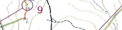
After the event went exploring in what will know be known as Lyell Central. It is rarely used due to the more obvious approaches and assembly areas being on Lyell Nth and Lyell South. Found an acceptable site which will go on the developing map web site in the next couple of days. Hope to actually run on this map next year now.
C • 1
C • 1
C • 6 1
Thursday Sep 1, 2016 #
3 PM
Running 40:27 [3] 6.0 km (6:45 / km) +65m 6:24 / km
shoes: ASIC Kayano green/white
Monday Aug 29, 2016 #
10 AM
Walking 4:15:00 [3] 12.5 km (20:24 / km) +900m 15:00 / km
Walk up Collins Bonnet and Collins Cap. Can't imagine better walking weather. Clear skies. Still except on the very top of the peaks. Max temp about 4 degrees.
Sunday Aug 28, 2016 #
10 AM
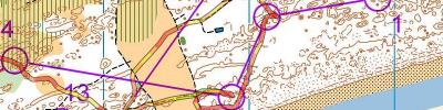
Real Orienteering race (Pittwater Dunes) 1:26:30 [3] ***** 8.5 km (10:11 / km) +50m 9:53 / km
spiked:18/22c shoes: Salamon Blue
Saw an event was on at Pittwater so we taook a long weekend to attend. The WMOC next year is in sand dunes, so this really is the only training opportunity. I don't have aspirations for WMOC other than not being in a C final. But even that requires some training. Entered M50 rather than M60 to get more distance. That gave me course 3. Course 2 would have been even better. I stopped at one point and waited for another competitor to get ahead. I didn't want to waste the trip following some one. This was all about practice.
Learnt a few lessons in the first part today, mainly related to mapping and control description conventions. Lessons-
2-3. When there is a control description for the start, don't just count from the top of the descriptions. Went looking for a gully when it was a depression on top of a ridge.
4-5. Major error of the day. Assumed that all trees would be mapped as white. They aren't even when you can easily traverse under them. Aimed for the next copse and ran for it without relaising the copse was mapped as part of the wider hatching for undergrowth. Took a while to work this out. It all made sense after a relocation. Other lesson- stick to the white as long as you can.
6-7 When you are concentrating hard on the detail, it still helps to actually count the track junctions.
15-16. Knoll Nth side means nth side of the top of the knoll, not north bottom.
16-22.. finally found me head in the terrain. Pity there wasn't an event on the Monday.