Training Log Archive: NadimIn the 7 days ending Apr 1, 2012:
| ||||||||||||||||||||||||||||||||||||||||||||||||||||||||||||||||||||||||||||||||||||||||||||
| « | » |
| » now | ||||||||||
| Mo | Tu | We | Th | Fr | Sa | Su | |||||||
Sunday Apr 1, 2012 #
Running (Trail) 1:47:51 [3] 12.41 mi (8:41 / mi) +359m 7:58 / mi
slept:7.3 weight:173lbs
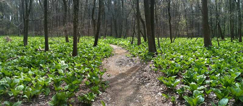
This trail was made over the last couple of years and only recently had been completed. It stays on the SE side of the creek. Spring is a good time to run most of the trails around D.C. but this one was quite picturesque. Most the woods were very open and in the section preceding the horse center, it was wide enough with some varied contours enough to support some o-training if mapped. I concur with Ken Walker's log regarding the beginning of the trail having the feel of running through people's back yards. This is over quickly. Though never far from houses, there are many times that one can't see any while at the same time being able to view far across open valleys. There were millions of tiny white/pink flowers on a low, almost grass-like ground cover. I got the feel of running through a garden. The trail was generally located well above the creek so despite the name of the trail, there was almost no mud (only at side streams). Conditions were quite good. Some side reentrants varied the slope and direction of the trail. There were occasional rocky outcrops but not many. The footing was rocky for only a short stretch before I turned around at the NW end of Blockhouse Conservation Park.

There were few people out though I saw a few. I passed one father-son duo heading up the trail on mountain bike (the trail seemed to be designed with this in mind). They spurred me to go a bit faster as we had to pass each other more than once on the ups and downs. There were lots of forks in the trail. Some of these appear to be due to relocation so even the blazes were pointed in the wrong direction. It wasn't very confusing but I did have to stop and think about it when I got to the the horse center. Generally, going downhill with the creek kept me on track.

I stopped and started a bunch along the way. This was to take pictures, adjust my belt, tighten my shoes, answer the phone, relieve myself, drink, etc... I never ate a Gu that I carried. My right knee hurt a little on the return. This might have been due to the change in slope with uphill generally being on my right side. On the return, I crossed paths with Eugene, a QOC regular who happens to live near enough to run this trail regularly.
Saturday Mar 31, 2012 #
Orienteering warm up/down (Foot) 46:32 1.7 mi (27:22 / mi) +90m 23:30 / mi
ahr:90 max:162 slept:7.0 weight:173.5lbs
Orienteering race (Foot) 1:36:54 8.7 km (11:08 / km) +400m 9:03 / km
ahr:146 max:161
I had a big error on #2. Thinking I was both taking a safe route and avoiding a big reentrant, I got too far off to the right, somehow crossing a major trail and getting onto a smaller one. It took me down the wrong ridge. Realizing it I had to cross a deep reentrant and did so going right to the control but I lost almost 5 minutes. Going to #6, I somehow miscounted some large reentrants going up one too soon. It was slow correcting going over some unmapped deadfall. I made an error going to #9 when I came off a trail bend--it was either the wrong trail bend or I should have angled better. I recovered by crossing a large reentrant at an angle but it took me time once across to figure the control was just behind me. I made a bonehead error going to #13 when I saw my control to the left but didn't see a fence at it as the control description indicated. Instead I ran to a bridge where another control was visible. I should have known the difference in locations but was running faster than my reading. I took the apparently slower route to #15 when trying to avoid climb. At #16, I approached from the fence and didn't see the control. tucked behind a tree. I ran to the larger reentrant but it appeared to be hung in a smaller unmapped one. It was a disappointing day but I got something out of it.
Friday Mar 30, 2012 #
Bicycling (Commute) 15:00 [1] 1.5 mi (10:00 / mi)
slept:5.5 weight:175.5lbs
Bicycling (Commute) 5:00 [3] 0.6 mi (8:20 / mi)
Bicycling (Commute) 6:15 [3] 1.41 mi (4:26 / mi)
Thursday Mar 29, 2012 #
Bicycling (Commute) 37:35 [3] 12.09 mi (3:07 / mi)
slept:5.25 weight:176lbs
Bicycling (Commute) 43:22 [3] 11.9 mi (3:39 / mi)
Wednesday Mar 28, 2012 #
Running (Street & Trail Commute) 29:57 [3] 3.85 mi (7:47 / mi)
slept:6.0 weight:175.5lbs
Tuesday Mar 27, 2012 #
Running (Trail) 1:18:25 9.15 mi (8:34 / mi)
slept:4.75 weight:176.5lbs
It had been too long since I had a longer trail run or long run in general--I've been mostly recovering or orienteering this month. The trail on the flatter and straighter west side of the creek was just right to get me going. I cruised up to Kemp Mill Rd. (28:36, 3.66 miles). It's always fun to run up the trail and springtime is the best. Today was just a little early as far as the height of beauty there goes. Low carpets of ground cover were green but neither these nor the trees were blooming much. The trail conditions were surprisingly good given the rainy weekend. It was odd running in Wheaton Regional Park. I've run far many more miles there doing orienteering so running the trails without a map made it all feel and look so different.
Leaves were not so visible in the shady Northwest Branch Creek valley except in wet and otherwise greener terrain. In Wheaton Regional Park, a wider but sunnier park surrounded by heat leaking houses, green terrain was similar as far as leaf growth. However the leaves were out on the tops of the tree canopy there. The leaves were not so visible under the same trees at lower levels.
My right knee was aching a little about midway through the run. It made me more cautious in rougher terrain on the return run. The Rachael Carlson Trail is pretty windy with many side forks. I was moving my feet fast over rocks and other things that could trip me and I worried about fatigue inducing a fall.
Parts of the trail had been rerouted again, swinging out away from the creek more, and getting closer to the edges of the park at reentrants. Creek erosion along the banks forced some of the relocations. Some bridges had been added including some improvised ones that took advantage of large fallen tree trunks. Uniformity of the types of ropes used at different tree trunks makes me believe the park service installed these rather than them being made by an active boy scout.
Monday Mar 26, 2012 #
Calisthenics (General) 2:00 [3]
slept:4.5 weight:174.5lbs (rest day)