Training Log Archive: wwkIn the 30 days ending Nov 30, 2012:
| ||||||||||||||||||||||||||||||||||||||||||||||||||||||||||||||||||||||||||||||||||||||||||||
| « | » |
| » now | ||||||||||||||||||||||||||||||||||
| Th | Fr | Sa | Su | Mo | Tu | We | Th | Fr | Sa | Su | Mo | Tu | We | Th | Fr | Sa | Su | Mo | Tu | We | Th | Fr | Sa | Su | Mo | Tu | We | Th | Fr | ||||||||
Wednesday Nov 21, 2012 #
boring inside exercise 35:00 [3]
shoes: Nike Structure 14
Inside at Cicotti center. 27:00 on elliptical, about 7:00 on the track.
Monday Nov 19, 2012 #
boring inside exercise 55:00 [3]
shoes: Nike Structure 14
Inside at Cicotti center -- 30 mins on the elliptical and about 25 mins on weight machines and laps on the inside track.
Sunday Nov 18, 2012 #
11 AM
Hiking 1:08:39 [1] 3.04 km (22:36 / km) +3m 22:30 / km
shoes: Nike Structure 14
At the Crossings -- pushing Max, while Zoe zooms around on her scooter and Stacey was off running. Walked around a bit then hit the playground.
Thursday Nov 15, 2012 #
11 AM
boring inside exercise 1:00:00 [3]
shoes: Nike Structure 14
At Cicotti center -- about 35mins on the elliptical and 25mins on the mixed walk/run on the indoor track. Even did a couple sprints.
Saturday Nov 10, 2012 #
4 PM
Run / Walk 36:40 [3] 4.84 km (7:35 / km) +7m 7:32 / km
shoes: Nike Structure 14
Run/walk intervals at the Crossings, near sunset. 5 min walk then 2 min run/1 min walk.
Friday Nov 9, 2012 #
12 PM
Field-Checking 3:27:29 [1] 7.69 km (26:58 / km) +80m 25:38 / km
shoes: Columbia Romero trail runners
Field checking at Colonie Mohawk River Park. An awesome day for it to, Around the 50s F, no rain and sunny, high visibility -- unlike all my field checking work this summer! A lot of the vegetation was gone, but some remained, making it very easy to pick out the fights from the open woods.
Had a checklist of places to correct from Frank's September meet. Fixed 'em all plus some other things I knew were off a bit. I had managed to straighten out some field boundaries (etc) from aerial orthophotographs from Phil, so I went back to re-fieldcheck those spots.
I was also excited to use my new mapboard. Since the only people who care about such things are the ones reading this, allow me to indulge.
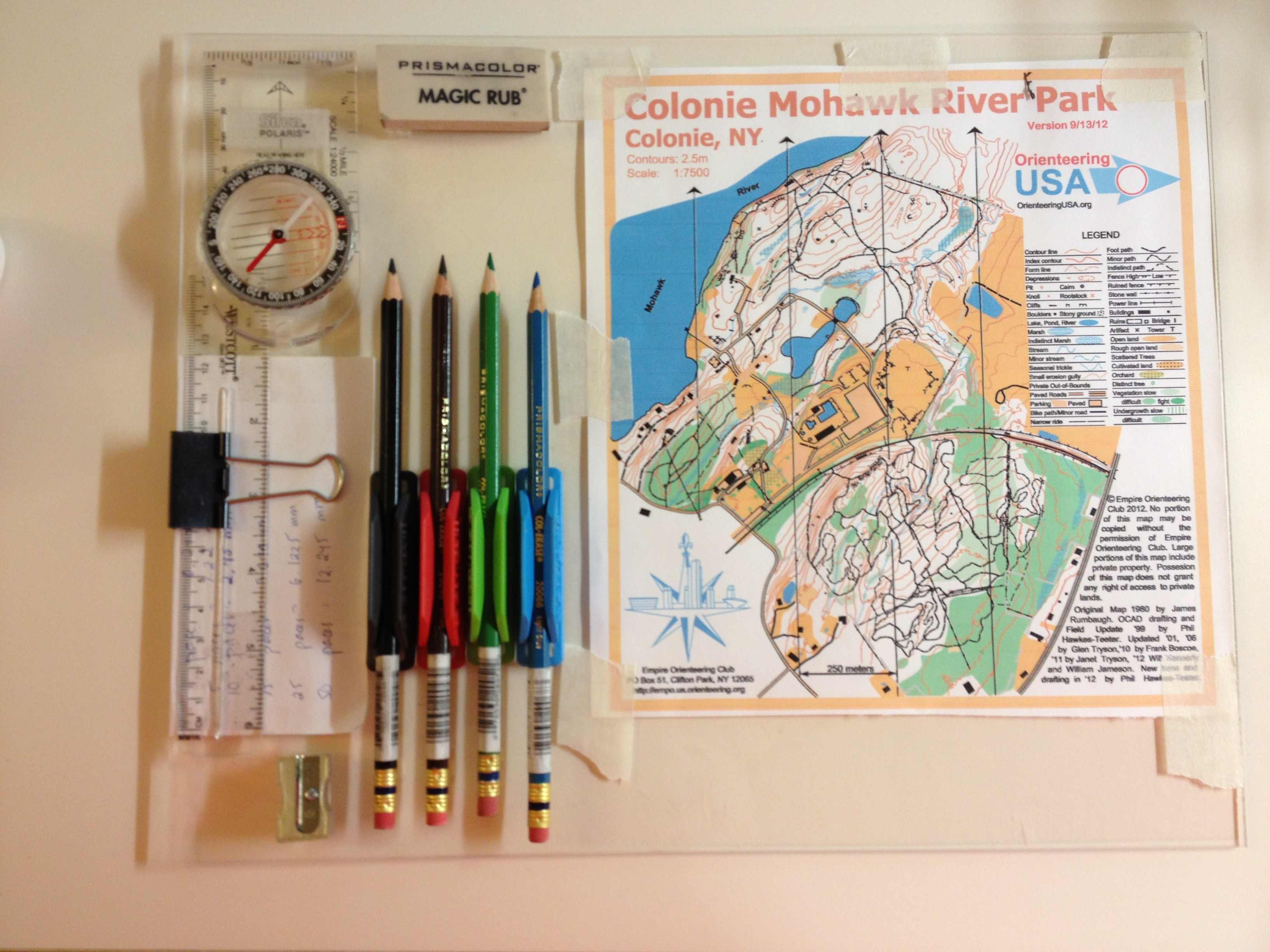
Its an 11x14 inch piece of acrylic from Home Depot - 4$
There's an empty area thats about 8.5x11 in for mounting letter-sized maps.
Then I mounted all the tools I needed. I used Scotch All-Weather fastners, which have a very strong adhesive; you cut a strip for each surface then they mate together like velcro, but even that connection is much stronger than velcro.
With such mightiness I mounted a $10 Silva Polaris compass (which can be detached when needed, but otherwise is firmly in place)
I also used the Scotch to attach a large rubber eraser but I haven't really needed it yet.
The colored pencils are Prismacolor Col-Erase -- erasables. They're mounted by little holders called Pen Pals. Four colors -- black, brown, blue, and green. The Pen Pals have their own adhesive, which seems pretty strong.
A small metal pencil sharpener also mounted by Scotch fastner strips.
A six-inch plastic ruler, supposedly shatterproof. I used a binder clip to clip it to the side of the board, which works, but I already managed to drop the ruler once (and I retraced 30 paces to find it again!). I think I'll get a little retractable leash for it.
I also need to get my pacecounting down right for a 1:7500 scale map and make up a little scale to tape down to the board--something that says "10 paces = 2.0 mm" etc. You can see some notes I made in the picture but I want to make that up better.
Then you by transparent single-tooth mylar sheets to lay over your map, tape downed by drafter's tape (which looks like masking tape but isn't as sticky, so you can peel it off without ripping paper).
Then you go out in the woods and make all your corrections by writing on the mylar layer. If you need to see the original map just flip up the mylar and there it is. So you get something like this:
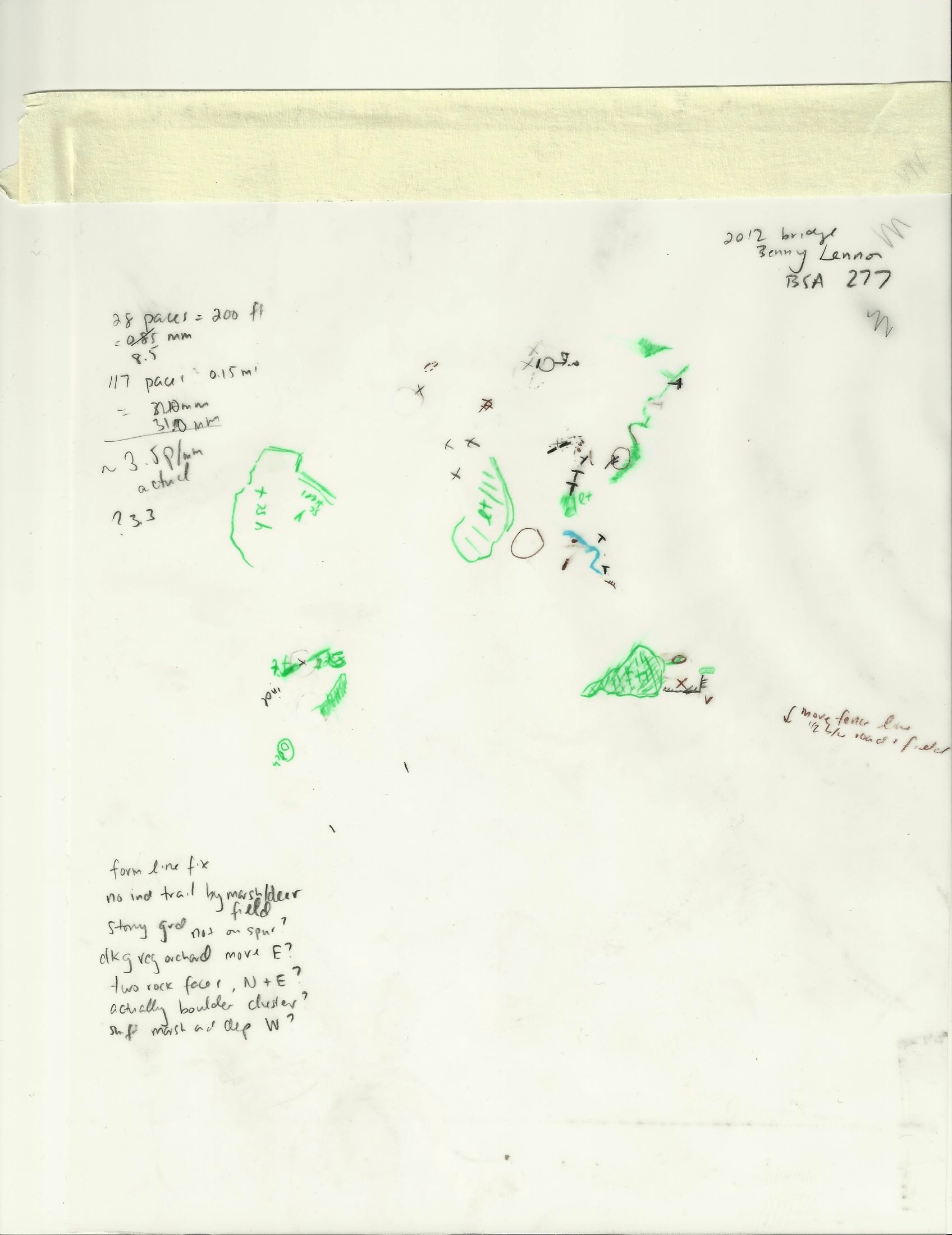
Then you scan that in, import into OCAD, and make all your corrections.
I bought the mylar sheets (~$1 each), the colored pencils (about $1 each), the pencil sharpener, and eraser at Arlene's Artist Supplies, which is conveniently across the street from my house and an awesome store.
I read a lot of posts on Yahoo's OMap listserve archive to get the ideas for what supplies to use, most of which I think came from an old message from JJ Cote. The ideas for putting it altogether so everything is attached to the mapboard were all mine.
Had a checklist of places to correct from Frank's September meet. Fixed 'em all plus some other things I knew were off a bit. I had managed to straighten out some field boundaries (etc) from aerial orthophotographs from Phil, so I went back to re-fieldcheck those spots.
I was also excited to use my new mapboard. Since the only people who care about such things are the ones reading this, allow me to indulge.
Its an 11x14 inch piece of acrylic from Home Depot - 4$
There's an empty area thats about 8.5x11 in for mounting letter-sized maps.
Then I mounted all the tools I needed. I used Scotch All-Weather fastners, which have a very strong adhesive; you cut a strip for each surface then they mate together like velcro, but even that connection is much stronger than velcro.
With such mightiness I mounted a $10 Silva Polaris compass (which can be detached when needed, but otherwise is firmly in place)
I also used the Scotch to attach a large rubber eraser but I haven't really needed it yet.
The colored pencils are Prismacolor Col-Erase -- erasables. They're mounted by little holders called Pen Pals. Four colors -- black, brown, blue, and green. The Pen Pals have their own adhesive, which seems pretty strong.
A small metal pencil sharpener also mounted by Scotch fastner strips.
A six-inch plastic ruler, supposedly shatterproof. I used a binder clip to clip it to the side of the board, which works, but I already managed to drop the ruler once (and I retraced 30 paces to find it again!). I think I'll get a little retractable leash for it.
I also need to get my pacecounting down right for a 1:7500 scale map and make up a little scale to tape down to the board--something that says "10 paces = 2.0 mm" etc. You can see some notes I made in the picture but I want to make that up better.
Then you by transparent single-tooth mylar sheets to lay over your map, tape downed by drafter's tape (which looks like masking tape but isn't as sticky, so you can peel it off without ripping paper).
Then you go out in the woods and make all your corrections by writing on the mylar layer. If you need to see the original map just flip up the mylar and there it is. So you get something like this:
Then you scan that in, import into OCAD, and make all your corrections.
I bought the mylar sheets (~$1 each), the colored pencils (about $1 each), the pencil sharpener, and eraser at Arlene's Artist Supplies, which is conveniently across the street from my house and an awesome store.
I read a lot of posts on Yahoo's OMap listserve archive to get the ideas for what supplies to use, most of which I think came from an old message from JJ Cote. The ideas for putting it altogether so everything is attached to the mapboard were all mine.
Monday Nov 5, 2012 #
boring inside exercise 1:00:00 [3]
shoes: Nike Structure 14
Gym at Cicotti Center -- 35 mins on elliptical, 25 mins of laps on the indoor track, about 1/2 running 1/2 walking. Walking was purposeful -- 76 paces = 1 lap, and I even looked at the sign that says how many feet 1 lap is, but I forgot what it said! I'm pacecounting to prep for mapping this week, with my new mapboard and all. But if I can't remember even one published distance, I might not be the guy you want making maps.
Saturday Nov 3, 2012 #
Orienteering race 1:29:02 [2] 4.8 km (18:33 / km) +35m 17:54 / km
shoes: Columbia Romero trail runners
Orange course at Woods Hollow, set by Bob Lange, on a new map of a small park near Saratoga. Went out with the whole family, Max on my back and Zoe taking the lead and punching most of the time while I navigated and Stacey escorted Zoe down to controls I didn't want to trudge down to :)
We didn't shy away from woods-routes either, though a lot of the saplings' branches had to be avoided lest they schwack Max in the face.
Pretty good course though a bit easy due to high visibility and lots of trails and other handrails. Though it would be hard to do much better I think. Towards the end there were two long trail run legs that were pretty unnecessary; could have skipped control 12 and it would have been fine. Only error was getting too far left off-line from 9 to 10. This whole part of the map could use more detail, lots of unmapped stuff.
A highlight was stumbling upon some teenager's beer stash about 20m behind someone's property. Considered partaking but it was bud light. Or maybe it was an unmarked refreshment stand? I'll have to ask Bob.
Orange course map
No GPS track -- forgot to start the watch!
We didn't shy away from woods-routes either, though a lot of the saplings' branches had to be avoided lest they schwack Max in the face.
Pretty good course though a bit easy due to high visibility and lots of trails and other handrails. Though it would be hard to do much better I think. Towards the end there were two long trail run legs that were pretty unnecessary; could have skipped control 12 and it would have been fine. Only error was getting too far left off-line from 9 to 10. This whole part of the map could use more detail, lots of unmapped stuff.
A highlight was stumbling upon some teenager's beer stash about 20m behind someone's property. Considered partaking but it was bud light. Or maybe it was an unmarked refreshment stand? I'll have to ask Bob.
Orange course map
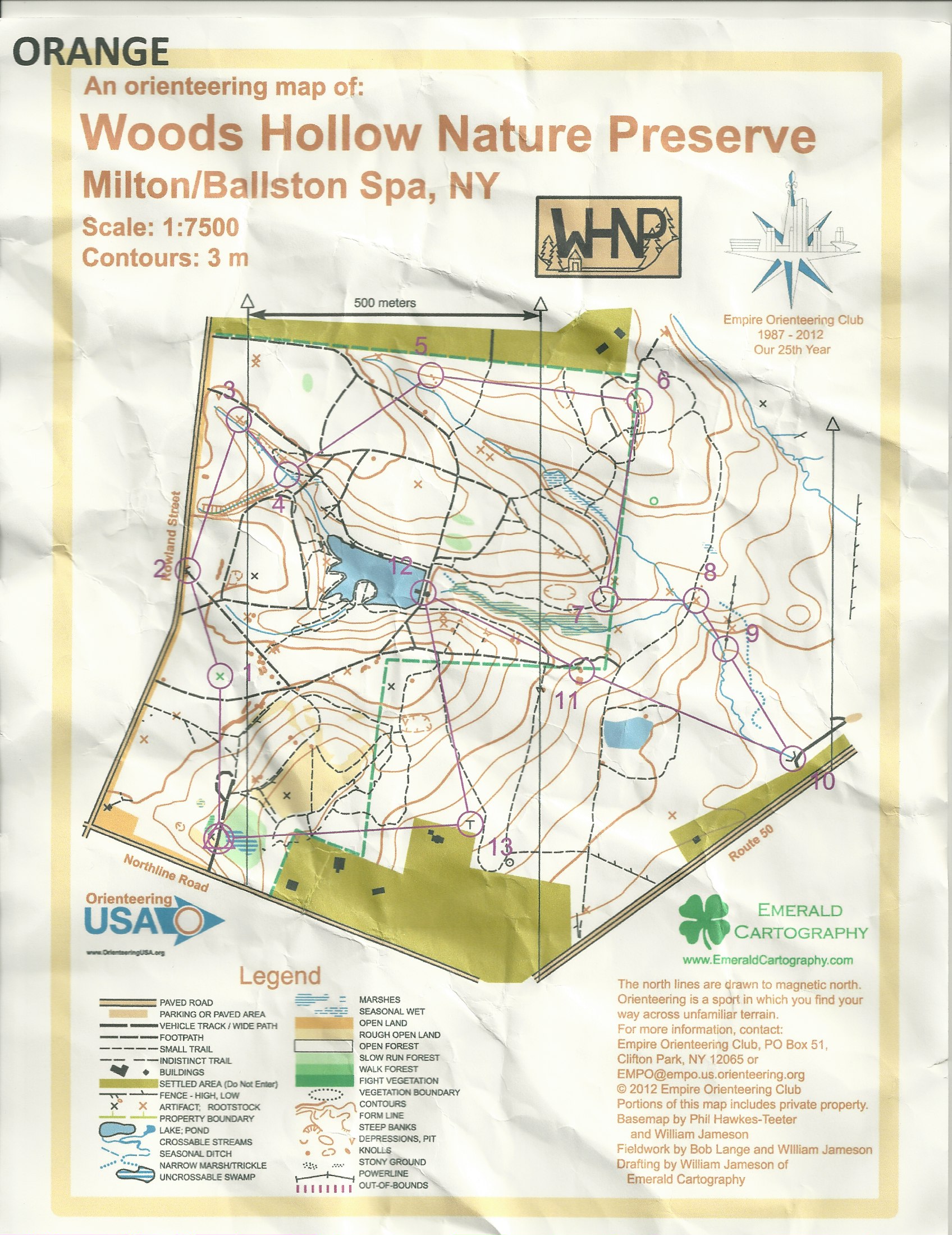
No GPS track -- forgot to start the watch!