Training Log Archive: CleverSkyIn the 7 days ending Aug 4, 2012:
| ||||||||||||||||||||||||||||||||||||||||||||||||||||||||||||||||||
| « | » |
| » now | ||||||||||
| Su | Mo | Tu | We | Th | Fr | Sa | |||||||
Saturday Aug 4, 2012 #
Note
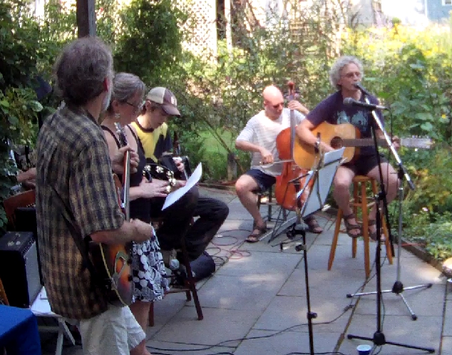
A zero for exercise. But the first real performance by The Holman Hack Band in over 27 years. Eight pieces (plus numerous other numbers by other people at the party, two of which included me).
Friday Aug 3, 2012 #
running race (carpet) 42 [5] 0.15 km (4:36 / km)
shoes: Nike Initiator
The Narrow Band Track Meet. This was pretty marginal as far as races go, and it was a disappointment relative to our expectations, but it did happen. At work we have a "test track" consisting of an instrumented mounting station for our radar sensors, and a motorized track that has a radar reflector mounted on it. You can program the track to move the reflector to simulate a moving car, at speeds up to 6 m/s. It accelerates pretty fast (we had it set to 5 m/s2), so in a race it can get the jump on a human, although 6 m/s is not that formidable a top speed. The track is 47 meters long, and we ran the reflector carriage from the 2 m mark to the 40 m mark, in order for the humans to have enough room to slow down before running into the far wall. So it was the 38 meter dash. I was the first one to try, doing four runs, with the carriage going at 2, 4, 5, and 6 m/s. The objective was to reach the 40 m mark before the carriage did. I succeeded at all speeds, as did Mat and Carl. This was all in honor of Scott's last day at work, but he was a no-show; we didn't realize until we were done that he had already turned in his badge and couldn't get in to the track area. Jorge didn't show up, either, nor did any of the spectators or judges. (Carl may have gone back with Scott afterwards -- I had to leave, so I'm not sure.)
Thursday Aug 2, 2012 #
exercises 1:55 [5]
25 pushups, 50 situps, 15 tableups, 25 squats.
Wednesday Aug 1, 2012 #
Note
Zero. Was planning on at least walking from home to the Ritter Building to get my car after a shuttle to get the old car back fro Ernie's, But Rob insisted on follwing me all the way home and giving me a ride to save me the trouble. Legs sore from yesterday anyway.
Tuesday Jul 31, 2012 #
running 2:12:10 [3] 12.0 mi (11:01 / mi)
Lunenburg Project #19.
Northfield Rd.
-> Turkey Hill Rd.
-> Oak Ave.
-> Main St.
-> Lancaster Ave.
-> Goodrich St.
<-> Winter Hill Rd.
-> Goodrich St.
<-> Linda Ln.?
-> Goodrich St.
<-> Easter Brook Rd.
-> Goodrich St.
-> Reservoir Rd.
-> Page St.
-> Arbor St.
-> Mass Ave.
-> Northfield Rd.
Well, this was a screwup. I got out of work early enough that I had time for some exercise, and I wanted to go for a run. I almost headed into the woods, but I took a quick glance at the map, and decided that maybe I could knock off Houghton's Mill. I did a quick check with gmap-pedometer, and the distance looked manageable, and I realized that I could also grab the road that connects from Reservoir Rd. to Lancaster Ave. on the way back. Going over Clark's Hill, I decided that it wouldn't be that interesting to climb it again on the way back, because there's a lot of traffic and not much shoulder. So instead I figured I could just go down Lancaster, take the connector road, then after Houghton's Mill I could return via Arbor. Seemed like a reasonable plan. I was trying to remember where the connector road turned off, and then I pictured it in my mind, just before Stillman's dairy farm. Yep, there it is, Goodrich. I had failed to notice that there were a couple of side roads that I needed to get as well. The thing I'm calling Linda Lane does not appear in the FD street directory. It looks like a three-way shared driveway that had to have a circle put in to make it qualify as a subdivision road, but the circle is just an abandoned ring of asphalt. No street sign. Or it could be more complicated than than, GoogleMaps shows that it's the back entrance to Rockin' C Ranch. But GoogleMaps has the wrong name for Winter Hill Rd., calling it Linda Lane, and I figure the name probably came from somewhere.
In any case, it was around the time that I was on Easter Brook Rd. that it occurred to me that something was wrong. That Goodrich was going to connect to Reservoir, but way south, almost down by Round Rd., not up north of Houghton's Mill. I was probably more than five miles from home. Sure enough, Goodrich came out where I remembered, and I started the long trudge back. What happened? I obviously missed the road that I had intended to take. I skipped Houghton's Mill, because this run was going to be long enough as it was. And shortly after that, I realized what happened as I passed the gated entrance to the Lunenburg Sportsmen's Club. I can now picture the dirt road on Lancaster Ave. that's the other end. gmap-pedometer shows it as a road, but it's not (can't tell from the satellite photos whether it even goes through, but I suspect it probably does). By the time I was getting to the north end of Arbor St., it was getting pretty dark. Once I got to Mass Ave, I walked the remaining 1.6 miles home. Weird feeling, though: when I stopped running, it was like I had no control of my legs, they went into a fast walking pace on their own and the rest of me was just along for the ride.
At least I got some exercise. And I got the east half of Goodrich, which I probably would have procrastinated on otherwise. But it was too far.
GPS track was pretty bad.
5 PM
pedaling 2:12:12 [3] 20.65 km (6:24 / km) +214m 6:05 / km
Monday Jul 30, 2012 #
Note
This one was a zero. Between work and band rehearsals, sometimes it's tough to also squeeze in enough time for exercise.
Sunday Jul 29, 2012 #
exercises 1:55 [5]
25 pushups, 50 situps, 15 tableups, 25 squats. I may have an extra day of these listed, not sure.