Training Log Archive: JanetTIn the 7 days ending Apr 4, 2015:
| |||||||||||||||||||||||||||||||||||||||||||||||||||||||||||||||||||||||||||||||
| « | » |
| » now | ||||||||||
| Su | Mo | Tu | We | Th | Fr | Sa | |||||||
Saturday Apr 4, 2015 #
Event: WCOC Huntington State Park
Note
This explains the many groups of three crosses we saw along our drive to/from Kentucky, given that West Virginia has 352 sets of them...
Cold and windy today, so we skipped driving to Huntington CT (where it always seems to be cold and windy for orienteering). A few more days resting my ankle won't hurt it.
At least it was really nice this past week, and it's not snowing. A promising start to spring. (Too bad Boston couldn't have shipped their winter snowfalls to California.)
Friday Apr 3, 2015 #
Note
We picked up our two weeks' worth of mail earlier, and I found two pieces that weren't for us, so I walked down to put them in our box. Testing the ankle too, which has been sore and achy since our hike to Cunningham Falls on Wednesday...still achy and running on it doesn't sound appealing.
Then I raked a bit around the plantings out front and picked up stray hickory branches and disposed of them. Snowdrops are up, and a few jonquil shoots are starting to appear, but not much sign of the daffodils yet; only about a half inch on one group of crocuses.
Then I raked a bit around the plantings out front and picked up stray hickory branches and disposed of them. Snowdrops are up, and a few jonquil shoots are starting to appear, but not much sign of the daffodils yet; only about a half inch on one group of crocuses.
Wednesday Apr 1, 2015 #
12 PM
Hiking 2:06:11 [2] 7.46 km (16:54 / km) +229m 14:39 / km
slept:7.0 shoes: Trail NB 704 8.5D
Catoctin National Park in Maryland (east of Hagerstown), temp about 45-50F
We hiked from the Visitors Center to Cunningham Falls (a 78' high cascade), and back, then took the side trail to the site of the Blue Blazes Still in the 1920s and 30s. When it was raided by local authorities in the early 30s (resulting in the death of a deputy sheriff) it was a much larger operation than they had expected, with eighteen 500-gallon vats to hold the moonshine; it was the largest such enterprise ever found in the county.
We hiked from the Visitors Center to Cunningham Falls (a 78' high cascade), and back, then took the side trail to the site of the Blue Blazes Still in the 1920s and 30s. When it was raided by local authorities in the early 30s (resulting in the death of a deputy sheriff) it was a much larger operation than they had expected, with eighteen 500-gallon vats to hold the moonshine; it was the largest such enterprise ever found in the county.
3 PM
Hiking 44:35 [1] 2.42 km (18:27 / km) +48m 16:47 / km
shoes: Trail NB 704 8.5D
After driving a short way up the park road we stopped at the parking area for an overlook and a nature trail. There were no brochures to describe what was at each of the 14 markers, and for the most part we couldn't figure out what might have been so remarkable about those stops. Hiked to Hog Rock and the vista (meh...at this time of year, with no leaves on the trees, it wasn't very impressive. The best time for these woods is the fall as leaf colors are changing.) and then looped back to the parking lot.
I read in the park brochure about things not to do in the park (stay on trails, don't take plants or rocks), and one statement was "no access to Camp David." Huh, I didn't realize it was so close. So I looked it up on my smartphone and found a satellite view that shows the entrance just down the park road from where we were. Of course we had to drive by. The sign out front reads "Camp #3. No public access." Neat.
Had dinner in Gettysburg at an Irish pub on Main Street called Garryowens. I couldn't help but think of the announcer for the 70s variety show Laugh-In, but I'm pretty sure it wasn't named for him. Beef stew for me; shepherds pie for Glen.
Monday Mar 30, 2015 #
Hiking 1:20:00 [1]
slept:8.0 shoes: Trail NB 704 8.5D
(Mostly copied from Glen's log :-))
At Carter Caves SP. Stayed over Sunday night at the park and did some hiking on Monday before we left. First hike was from the Long course start out to Glen's Middle course control #5 (code 33) to take some pictures of the "waterfall in a hole" feature. Then we drove to the Cascade area of the park and hiked the loop trail there to see another stone arch (Cascade Bridge) and the Box Canyon, another giant rock feature. It was sunny and in the 50s so a little more comfortable in the woods than it had been over the weekend.
Stopped at the New River Gorge (north of Beckley, WV) on our drive towards Charlottesville, VA. Strolled around at the Visitor Center overlooking the gorge and the very impressive bridge which carries US Rt 119 across it.
Sunday Mar 29, 2015 #
Note
9:30 am There's a control in the woods visible from our balcony at the lodge. Just saw a runner come through. :-)
10 AM
Running (paved) warm up/down 2:30 [2] 0.33 km (7:35 / km) +1m 7:28 / km
shoes: Inov8 ORoc280-A 2013-08
Very short warm-up near the start just to get the legs and brain in gear.
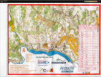
Orienteering race (middle) 47:49 [4] *** 3.54 km (13:31 / km) +133m 11:23 / km
spiked:11/15c shoes: Inov8 ORoc280-A 2013-08
US Middle Championships on the Smokey Bridge and Shangra La map
1:10000, 5m / 3.2 km 140m
upper 30s and partial sun, still some breeze
Yay -- a better run today despite small errors here and there (and at least a minute lost to 4 as I investigated up the ditch rather than across the ditch); AP has me listed with about 4 minutes or so of error.
Watched Natalia out of the start today (forgot to even look yesterday to see if I could see which way Brown runners were going); she started a few minutes ahead of me. Once I turned over my map I turned left too, and ran the trail until almost at the bend (past the weird unknown green blobs on either side of the trail). 3-4 I followed a good line down the hill, I think, but then was distracted by other small depressions near the ditch that weren't mapped, before realizing I had to be on the next spur. A little high on 5 but there were other runners around. I think I caught up to Patty L here, or at 6. Saw her most of the rest of the way around either ahead or behind me; she had made mistakes early, but said my being there pushed her to keep up the pace.
I apparently missed going over the Shangra La arch between 6 and 7 by just a bit (the cave/arch mapping is confusing and hard to read at speed). High on my approach to 11, passing what turned out to be a Green course control in the wide reentrant WSW of the boulder (Tony M on Green made a comment here to the effect I was too high; he had probably come right by my control). The rest was good, chasing Patty and trying to keep up speed. I could NOT run any of the final uphill leg to the finish; just too steep, and my split time shows it.
While looking at results (Mary Jo about 5 minutes ahead) I kept wondering where Natalia was; she finished several minutes later and I found out her tale of woe on #3. Finished 2/10 in F60. :-)
Very nice Middle course capturing the essence of the discipline. Winning times were in the low 30s, so just a slight touch on the long side. Not as much over as the sprints which were about 30% too long, while the Long courses (at least Green and Brown) were a bit short.
Hope this is the end of 30's temps for orienteering for awhile.
My Quickroute --
 |
| From Track jpg files |
3 PM
Hiking 2:00:00 [1]
After the event we visited Smokey Bridge, an arch area over a cave that we had run across coming into the finish. Mike announced at the results that it was there, so it needed investigation.
Next we took a hike from the lodge down to the Raven Bridge; about an hour loop. Then we drove down to the Welcome Center and hiked under the road through the large, long cave that the other Brown course ran through on their Long courses yesterday. It has a hole in the roof/arch that you can hike to from the trail on the other side.
And finally we hiked a short trail that goes from near the entrance of X Cave to the other end; we could see up to the landing where we exited one side of the cave and re-entered the other. Maybe I'll post some pictures later if I don't fall asleep first.