Training Log Archive: JayXCIn the 8 days ending Jun 14, 2019:
| |||||||||||||||||||||||||||||||||||||||||||||||||||||||||||||||||||||||||||||||
| « | » |
| » now | |||||||||||
| Fr | Sa | Su | Mo | Tu | We | Th | Fr | |||||||
Friday Jun 14, 2019 #
Note
slept:5.0 (rest day)
Unpacking and cleaning gear with a nap mixed in.
Thursday Jun 13, 2019 #
Note
slept:7.0 (rest day)
Bus ride from Santo Domingo to Quito, gear sorting and packing at Proyecto Aventura HQ then UIO-MIA-PHL-ROC.
Wednesday Jun 12, 2019 #
6 AM
Trek 7:30:00 [3] 20.0 km (22:30 / km)
slept:4.0 shoes: Brooks Cascadia 12 (green)
We found a reasonably flat, dry spot and unloaded our bivys and the bothy bag and climbed in. Then the rain started. As it turns out the bothy bag is not nearly big enough to cover 4 people laying down and it is not waterproof. Our earlier decision to not bring my tent on this leg now seemed pretty foolish. What followed was about 2 hours of sleeping and 4 hours of uncontrollable shivering.
Fortunately the rain stopped just before dawn. We crawled out of our bivy's and ate some race food for breakfast. The area was clouded in but in small breaks we could make out our position. Dave immediately identified the trail across the valley as the trail we had climbed up towards CP19.

we slept here.
With our position confirmed we packed up and climbed up and over to the opposite side of the spur we were on and into the correct valley, where we had been 13 hours before.
While descending down the valley we ran into two race staff and they let us know about the carnage relative to teams getting lost, dropping out, etc. They presented a car ride if we wanted it but we were feeling fine and preferred to get to the next TA which was about 20k away still. The valley floor was essentially turbal but with a little less water so you could actually stay relatively dry as you trekked.

We traveled through a small town and looked for some Cokes but came up empty. The town was just before the climb up to CP20 which was the check-in for the ropes course, unfortunately the ropes had been cleared prior to our arrival. It was raining on and off and very windy so I doubt we would have been allowed to go up on the spire anyways. It looked awesome.

An Alpaka on autopilot
From CP20 it should have been all down hill to the TA but Dave and I both misinterpreted the out of bounds road and we ended up with a slight detour with a little more climbing while headed into town. It did offer up this cool shot of the ropes course over our shoulders though.
We were greeted at the TA and informed that we would be shuttled to the finish where we could unload our bikes and ride across the finish line. Our bikes were already in the boxes and it seemed like way too much of effort for a photo which is why you can see Shane wearing flip-flops in some of our finish photos.
Overall not crossing the finish line as official finishers sucks. Without the mix up at CP19 I'm pretty sure we would have completed the ropes, been short-coursed at the next trek leg and ridden to the finish which would have been much more rewarding. Given that even Columbia couldn't finish this course in the time allotted tells me it was way too big to begin with.
Having said that though I have to commend the organization otherwise. It’s been my experience at some overseas races that as soon as the race ends the organization and volunteer networks seem to disappear. We had excellent assistance here right up until we departed for the airport.
Fortunately the rain stopped just before dawn. We crawled out of our bivy's and ate some race food for breakfast. The area was clouded in but in small breaks we could make out our position. Dave immediately identified the trail across the valley as the trail we had climbed up towards CP19.
we slept here.
With our position confirmed we packed up and climbed up and over to the opposite side of the spur we were on and into the correct valley, where we had been 13 hours before.
While descending down the valley we ran into two race staff and they let us know about the carnage relative to teams getting lost, dropping out, etc. They presented a car ride if we wanted it but we were feeling fine and preferred to get to the next TA which was about 20k away still. The valley floor was essentially turbal but with a little less water so you could actually stay relatively dry as you trekked.
We traveled through a small town and looked for some Cokes but came up empty. The town was just before the climb up to CP20 which was the check-in for the ropes course, unfortunately the ropes had been cleared prior to our arrival. It was raining on and off and very windy so I doubt we would have been allowed to go up on the spire anyways. It looked awesome.
An Alpaka on autopilot
From CP20 it should have been all down hill to the TA but Dave and I both misinterpreted the out of bounds road and we ended up with a slight detour with a little more climbing while headed into town. It did offer up this cool shot of the ropes course over our shoulders though.
We were greeted at the TA and informed that we would be shuttled to the finish where we could unload our bikes and ride across the finish line. Our bikes were already in the boxes and it seemed like way too much of effort for a photo which is why you can see Shane wearing flip-flops in some of our finish photos.
Overall not crossing the finish line as official finishers sucks. Without the mix up at CP19 I'm pretty sure we would have completed the ropes, been short-coursed at the next trek leg and ridden to the finish which would have been much more rewarding. Given that even Columbia couldn't finish this course in the time allotted tells me it was way too big to begin with.
Having said that though I have to commend the organization otherwise. It’s been my experience at some overseas races that as soon as the race ends the organization and volunteer networks seem to disappear. We had excellent assistance here right up until we departed for the airport.
Tuesday Jun 11, 2019 #
12 AM
Trek 21:20:00 [3] 20.0 km (1:04:00 / km)
slept:0.67 shoes: Brooks Cascadia 12 (green)
With a solid 45 minutes of sleep banked we continued on towards our next CP which was in the town of Angenarca perched up the other side of the valley which meant more climbing.
We picked up some Cokes in town and then spent way too much time wandering around trying to find the trail out. More climbing and some sleep walking ensued until daylight.
At daylight the real climbing commenced. We identified the correct spur and found the trail indicated on the map which led to the town at the top but the trail was very overgrown and obviously not the way everyone else had taken. The only other option seemed to ascend up the opposite side of the spur and was not on the map but we gave it a shot and it turned out to be correct. It was sprinkling on and off as we climbed and it turned the trail into a slimy mess with peanut butter mud clinging to your shoes.
As we approached the 'town' there was some strange music blasting from a school. Shane described it as an orchestra on acid I think. It was on a continuous loop and is now burned into my memory.
Once at the village we entered yet another valley/spur trail and continued on that for the remainder of the afternoon. This would lead us straight to the infamous CP19.
As we approached CP19 (high point on the course) it looked kind of challenging as the saddle it was located in was very subtle. We fanned out while hunting for it and not much later Dave had it. Dave took a bearing and we started walking due north on a ridge to find the valley we needed to descend into to get down. Picking the wrong spur would be easy to do given how subtle the terrain changes were in this area. Looking at our GPS track it looks like we nailed it and actually started down into it before second-guessing our position and then deciding to verify it. A classic case of Too Many Chefs on Map. This was unfortunate and essentially cost us an official finish.

Timing of this decision couldn't have been any worse. As we walked back towards CP19 daylight was waning and by the time we had re-attacked it was dark. We could not see into the valley to confirm our position and we would now be guessing if we were correct. We wandered back and forth a few times looking for the trail on the map and then decided to take a short nap.
When we woke up the weather was getting worse and Shane decided he wanted a shot at finding the trail. He took a bearing and we set off but without daylight to help, finding the trail was impossible. We ended up getting onto a wrong spur and ultimately got cliffed out. At this point we decided it was better to wait until daylight to figure it out.
We picked up some Cokes in town and then spent way too much time wandering around trying to find the trail out. More climbing and some sleep walking ensued until daylight.
At daylight the real climbing commenced. We identified the correct spur and found the trail indicated on the map which led to the town at the top but the trail was very overgrown and obviously not the way everyone else had taken. The only other option seemed to ascend up the opposite side of the spur and was not on the map but we gave it a shot and it turned out to be correct. It was sprinkling on and off as we climbed and it turned the trail into a slimy mess with peanut butter mud clinging to your shoes.
As we approached the 'town' there was some strange music blasting from a school. Shane described it as an orchestra on acid I think. It was on a continuous loop and is now burned into my memory.
Once at the village we entered yet another valley/spur trail and continued on that for the remainder of the afternoon. This would lead us straight to the infamous CP19.
As we approached CP19 (high point on the course) it looked kind of challenging as the saddle it was located in was very subtle. We fanned out while hunting for it and not much later Dave had it. Dave took a bearing and we started walking due north on a ridge to find the valley we needed to descend into to get down. Picking the wrong spur would be easy to do given how subtle the terrain changes were in this area. Looking at our GPS track it looks like we nailed it and actually started down into it before second-guessing our position and then deciding to verify it. A classic case of Too Many Chefs on Map. This was unfortunate and essentially cost us an official finish.
Timing of this decision couldn't have been any worse. As we walked back towards CP19 daylight was waning and by the time we had re-attacked it was dark. We could not see into the valley to confirm our position and we would now be guessing if we were correct. We wandered back and forth a few times looking for the trail on the map and then decided to take a short nap.
When we woke up the weather was getting worse and Shane decided he wanted a shot at finding the trail. He took a bearing and we set off but without daylight to help, finding the trail was impossible. We ended up getting onto a wrong spur and ultimately got cliffed out. At this point we decided it was better to wait until daylight to figure it out.
Monday Jun 10, 2019 #
12 AM
Mtn Bike 9:13:00 [3] 63.0 km (6.8 kph)
slept:0.0
By midnight all of the easy climbing was done and we were climbing in our smallest gearing on the steep sections or hiking with the bike. These were long, steep sections of 2-3k each and there were a ton of them and it seemed like we were making slow progress.
I knew the TA in Pinilopata was near 4300m elevation and I was getting pretty excited around 4am when I saw we were around 3900m. Unfortunately I didn't look close enough at the route originally otherwise I would have recognized that there was a long 800m descent down into a valley prior to climbing up to the TA.
Apparently the schools open pretty early in this part of Ecuador because by 5:30a we were getting passed by buses, cars, trucks, scooters, etc with school kids on their way to school. Each school kid stared at us as they went by with a strange look on their face which I interpreted to be Spanish for 'What the heck are you guys doing??'

By early morning the roads started to improve and we were finally able to ride most of the route, arriving at the TA in the center of town around 10 am.
I knew the TA in Pinilopata was near 4300m elevation and I was getting pretty excited around 4am when I saw we were around 3900m. Unfortunately I didn't look close enough at the route originally otherwise I would have recognized that there was a long 800m descent down into a valley prior to climbing up to the TA.
Apparently the schools open pretty early in this part of Ecuador because by 5:30a we were getting passed by buses, cars, trucks, scooters, etc with school kids on their way to school. Each school kid stared at us as they went by with a strange look on their face which I interpreted to be Spanish for 'What the heck are you guys doing??'
By early morning the roads started to improve and we were finally able to ride most of the route, arriving at the TA in the center of town around 10 am.
9 AM
Trek 14:47:00 [3] 20.0 km (44:21 / km)
shoes: Brooks Cascadia 12 (green)
I think we arrived at TA2 in 7th place. The actual TA location was in the town square in some type of a covered shelter. There was a funeral occurring at the opposite end of it which was unfortunate.
We expected this next leg to be about 26 hours, essentially the equivalent of a 24 hr Rogaine in the middle of an expedition AR. On top of all of the food we would need we also had to bring along our ropes gear which made for a pretty heavy pack. Fortunately I was well prepared for this given the ridiculously heavy packs required at XPD OR.
Not surprisingly the first CP for this leg was on the valley floor. We quickly found a fisherman's path which led us straight down 800m on a spur to the CP.
We would be hiking up the switchback trail on the opposite side on our way to the second CP. Once back up the other side we followed a series of trails which contoured the valley. We spent the rest of the daylight on this route. Our progress was slow and I over-estimated how far we had traveled and we started searching for the next CP about 2k too early. The terrain seemed to match up well and there was a 90 turn in the river below which gave additional false confidence. What followed was a lot of attacking and re-attacking through a farmers pasture multiple times.
The hillside was very steep and in one instance while we were crawling under a barbed wire fence Shane threw his pack ahead of him a little to get it out of the way. The hillside we were on was very steep and that additional energy was all that was necessary to send his pack tumbling down the hill. Dave dove after it as it went by him but it was accelerating too fast for him to catch it and it quickly tumbled out of his headlamp view. We all stood stunned as we listened to it continue to crash through the weeds as fell. Rachel found it particularly hilarious and giggled the entire time it took us to down climb to find it. Fortunately we eventually found it and it had held together.
We eventually realized we had not gone far enough and decided to continue on but not before a local farmer gave us a few clues as to where we were. The clues came with a price however and he insisted that we join him in his farmhouse until morning. It might have been fun given the amount of singing we had heard coming from it earlier but we had places to go now. We really needed to find this CP. It was located on the trail at the only river crossing in the valley. The river was flowing way to high to cross anywhere else.
Fortunately the farmer clues helped and we found the correct trail in the maze and then the CP (mill). We considered sleeping there but the area was soaking wet and the door to the mill was locked. We continued on and about an hour later found a concrete bridge which looked inviting for a nap.
Sunday Jun 9, 2019 #
2 AM
Note
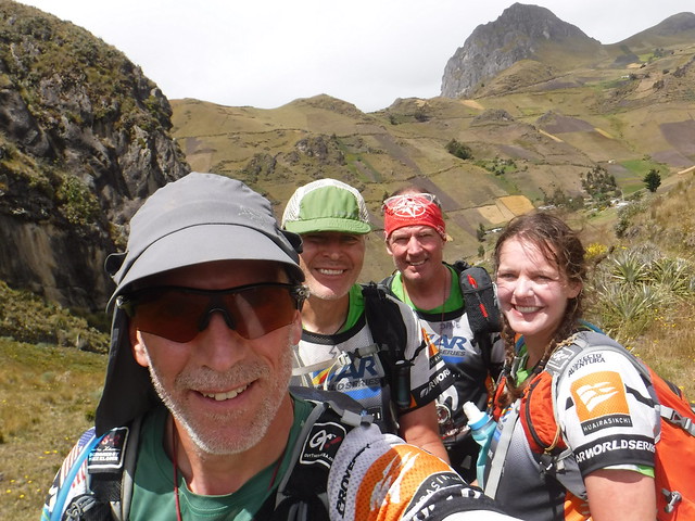
Huairasinchi '19 with Rocky33, DML and Shane Hagerman.
It was an early wake up for the 2am bus ride to the start area. We still had not seen any maps. There was (impossible) no way to get any sleep on the bumpy ride but everyone tried anyways.
We finally arrived at a small school around 6:00am. We unloaded, picked up our trackers and had our phones wrapped/secured then loaded into classrooms for the first look at our maps. No one was allowed to leave the rooms without an escort. We poured through the maps highlighting our intended route and then transferred that onto our second set with minutes to spare. Map scale- 1:50,000, 40m contours.
7 AM
Trek 1:00:00 [3] 7.0 km (8:34 / km)
shoes: Brooks Cascadias 11
The start was simple enough. Everyone under the banner and then go. First up was a 5.5k run to the boats with all of the paddle gear on a jeep track. The backrest mounts in some of the sit on top kayaks were missing. We planned to use backrests so there was some urgency to get to the put-in ahead of some of the teams to be sure we had a decent selection to choose from. We jogged most of it and were in the top 10 at CP1.
8 AM
Kayak 6:22:00 [3] 39.0 km (6.1 kph)
slept:5.0
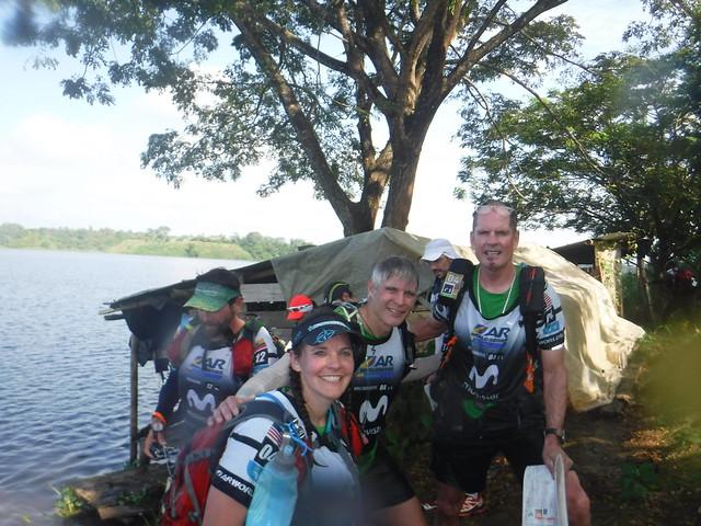
The paddle on the map looked pretty interesting. We would be paddling on a giant reservoir with long narrow fingers, tiny islands everywhere and very low high ground to use as references. Each of the waterfront structures were numbered on the map however and Dave and I used them to re-enforce our position as we paddled.
We left CP1 heading north expecting to paddle right to CP2. After about 3k we paddled into a narrow channel clogged by floating vegetation. it didn't look like it was passable and there were teams exploring to be sure. We still had 2k to go until CP2. As we approached we could see a few teams running along the right shore heading north and we quickly decided to join them. The 'takeout' was a floating marsh pad and if you stood in one position for long you would sink into a weedy mess.
We made it up to the high ground and followed the beat in path to the CP which included 3 swims each way. Fortunately I closed my drybag securely and my warm weather gear stayed dry. We ran into a number of teams on the out and back route.
Back into the boats and into the clear water. It was already smoking hot out. We set up the tow between the boats which allowed Rachel and I to stay in the draft of Dave and Shane for the majority of the remaining paddle.

We nailed CP6 on the back side of a small peninsula which a lot of teams ahead of us struggled with. As we were approaching CP7 we could see the leaders coming back towards us. The lead 3 teams were locked up head to toe with #4 not far behind. We were 5th but about 30 minutes behind.
We left CP1 heading north expecting to paddle right to CP2. After about 3k we paddled into a narrow channel clogged by floating vegetation. it didn't look like it was passable and there were teams exploring to be sure. We still had 2k to go until CP2. As we approached we could see a few teams running along the right shore heading north and we quickly decided to join them. The 'takeout' was a floating marsh pad and if you stood in one position for long you would sink into a weedy mess.
We made it up to the high ground and followed the beat in path to the CP which included 3 swims each way. Fortunately I closed my drybag securely and my warm weather gear stayed dry. We ran into a number of teams on the out and back route.
Back into the boats and into the clear water. It was already smoking hot out. We set up the tow between the boats which allowed Rachel and I to stay in the draft of Dave and Shane for the majority of the remaining paddle.
We nailed CP6 on the back side of a small peninsula which a lot of teams ahead of us struggled with. As we were approaching CP7 we could see the leaders coming back towards us. The lead 3 teams were locked up head to toe with #4 not far behind. We were 5th but about 30 minutes behind.
2 PM
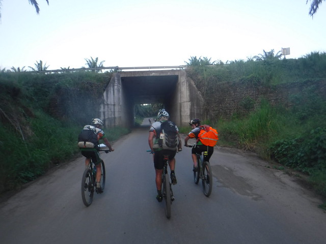
Mtn Bike 9:08:00 [3] 75.0 km (8.2 kph)
I enjoy a good sit on top paddle as much as the next person but I was happy to be done when we arrived at the TA. These boats seemed to be built for a much shorter person and my legs felt cramped with my feet in the foot wells.
We had a fair transition. I'm not sure how we spent 45 minutes there but I was busy the entire time. The heat was taking a toll on some of the teams including ours so we took it easy for the first few hours. We were riding east towards the mountains and the terrain was relatively flat and fast.

We travelled through a few small villages as we went and I got a kick out of all of the scooters the locals used to get around. The minimum occupancy is apparently two riders, we did see multiple instances of 3-5 riders on one bike.
As we rolled through the busy city of Quevedo dodging traffic coming at us from all directions we were joined by a guy blasting music out of a handmade radio on his bike and a guy on a motorcycle who later when we stopped for water showed us a picture of his cycling team he carries around for just this occasion apparently.
Just after dusk we started the climbing, nothing too steep but just enough to slow you down and at an effort which required constant pedaling to stay moving. There were no down hills it seemed.
We had a fair transition. I'm not sure how we spent 45 minutes there but I was busy the entire time. The heat was taking a toll on some of the teams including ours so we took it easy for the first few hours. We were riding east towards the mountains and the terrain was relatively flat and fast.
We travelled through a few small villages as we went and I got a kick out of all of the scooters the locals used to get around. The minimum occupancy is apparently two riders, we did see multiple instances of 3-5 riders on one bike.
As we rolled through the busy city of Quevedo dodging traffic coming at us from all directions we were joined by a guy blasting music out of a handmade radio on his bike and a guy on a motorcycle who later when we stopped for water showed us a picture of his cycling team he carries around for just this occasion apparently.
Just after dusk we started the climbing, nothing too steep but just enough to slow you down and at an effort which required constant pedaling to stay moving. There were no down hills it seemed.
Saturday Jun 8, 2019 #
Event: Huairasinchi
Note
slept:7.5 (rest day)
Packing-registration-skills check-prerace mtg-Shaman
Friday Jun 7, 2019 #
Note
slept:9.0 (rest day)
Travel from Quito to Santo Domingo.
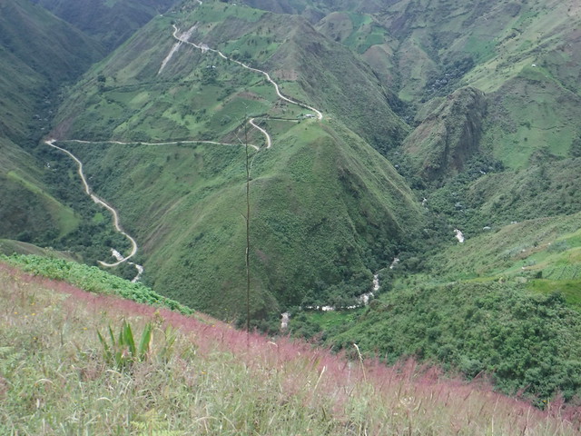
This was via a coach on a road with about 500 switchbacks from 8500' to 800'. Santo Domingo is a popular tourist destination and the route has multiple small towns along the way with street vendors in the middle of the road with buses and semis passing in both directions all trying to sell ice cream, colored water and sugar cane chunks. These people are fearless and work very hard for small change.
This was via a coach on a road with about 500 switchbacks from 8500' to 800'. Santo Domingo is a popular tourist destination and the route has multiple small towns along the way with street vendors in the middle of the road with buses and semis passing in both directions all trying to sell ice cream, colored water and sugar cane chunks. These people are fearless and work very hard for small change.