Training Log Archive: PGIn the 1 days ending Jan 19, 2009:
| ||||||||||||||||||||||||||||||||||||||||||||||||||||||||||||||||||
| « | » |
| » now | ||||
| Mo |
Monday Jan 19, 2009 #
Note
Most every place around here the best map available is the USGS topo map, which a lot of the time is pretty good. Or, at least, used to be pretty good, back when I was first lived in western Massachusetts about 35 years ago. Before too long I had a copy of most of the topos in this part of the state. And I'm glad I did, and glad I kept them. Because they are so much better than the new and improved (and I assume digitally created) topos that you can get now, or that are used in applications like Gmaps-pedometer.
And that's such a shame. Somewhere, someplace, there's someone who is responsible for this....
Here's what I mean --
First, from Saturday's walk, here's the old version --

and the new version --
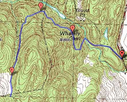
For example, right above the words "Whately Glen" on the old map is a nice elongated knoll on the old map, very distinct out in the terrain, totally gone form the new map. The hillsides have some "character" on the old map (changes in slope that can tell you where you are). On the new map the slopes are uniform. And so on and so on.
And from Sunday, here's the old version --

and the new version --

Look at the terrain I went through between mile marks 2 and 3. Looks totally different. And the old one, which is what I had with me, was good enough to know pretty much where you were the whole time, even though the trails weren't mapped.
Im not normally a Luddite, but in this case, this is progress?
And that's such a shame. Somewhere, someplace, there's someone who is responsible for this....
Here's what I mean --
First, from Saturday's walk, here's the old version --
and the new version --
For example, right above the words "Whately Glen" on the old map is a nice elongated knoll on the old map, very distinct out in the terrain, totally gone form the new map. The hillsides have some "character" on the old map (changes in slope that can tell you where you are). On the new map the slopes are uniform. And so on and so on.
And from Sunday, here's the old version --
and the new version --
Look at the terrain I went through between mile marks 2 and 3. Looks totally different. And the old one, which is what I had with me, was good enough to know pretty much where you were the whole time, even though the trails weren't mapped.
Im not normally a Luddite, but in this case, this is progress?
nautilus 35:00 [1]
Starting to get the weights up a little.
treadmill 11:00 [2] 1.0 mi (11:00 / mi)
Some gentle jogging. Seemed not too bad as long as I kept the stride length real short.
rogaine base building 32:19 1.7 mi (19:01 / mi)
South Sugarloaf. 18:33 up, 13:46 down. Very soft footing, hard work on the way up.
Note
Almost forgot, had a great view of a peregrine falcon at the top of Sugarloaf. It took off just to my left, flew right in front of me, heading SSW at a very high rate of speed. I assume it just decided it really didn't want to miss the inauguration.
Very cool, don't think I've ever seen one before.
In the spring they nest in the cliffs just below the summit.
Very cool, don't think I've ever seen one before.
In the spring they nest in the cliffs just below the summit.