Training Log Archive: PGIn the 30 days ending Nov 30, 2008:
| ||||||||||||||||||||||||||||||||||||||||||||||||||||||||||||||||||||||||||||||||||||||||||||||||||||||||||||||||||||||||||||||||||||||||||||||||||||||||||||||||||||||||||
| « | » |
| » now | ||||||||||||||||||||||||||||||||||||||||||||||||||||||||||||
| Sa | Su | Mo | Tu | We | Th | Fr | Sa | Su | Mo | Tu | We | Th | Fr | Sa | Su | Mo | Tu | We | Th | Fr | Sa | Su | Mo | Tu | We | Th | Fr | Sa | Su | ||||||||||||||||||||||||||||||||||
Sunday Nov 30, 2008 #
hike 45:47 [1] 2.6 mi (17:37 / mi)
hike 39:11 [1] 2.6 mi (15:04 / mi)
Note
It reminds me of back when I was putting out Ultrarunning. For many years there were three of us doing it, and one of the basic rules was, "Whoever is doing the work, decides."
So if I was doing the page layouts, which I usually was, then whatever I did was it, no need to check with the others, no group approval needed, no wasting a lot of time. Because in all honesty, if there was a page or two in the magazine that could have been a little different, maybe better, maybe not, it wasn't all that important, it wasn't some matter of life and death. Just do it and move on.
The rules for the Sprint Series for 2009 will be a little different than prior years. That's good. It's also not a bad thing to see a few folks getting their blood pressure up a little bit about the changes. Far better having that than if no one is interested at all.
And the best and most important rule is rule #1 -- Rules may be added, changed, or deleted at any time by The Deciders.
No committees, no protests, no grievances, no sanctions.
What I sometimes think is the best form of government, a benevolent dictatorship.
Saturday Nov 29, 2008 #
nautilus 45:00 [1]
Note
Friday Nov 28, 2008 #
nautilus 5:00 [1]
Note
And Zack showed off his skills going both up the steps and down....

And Gail looked gorgeous....

And Charlie did some more thinking....
A very fine visit.
Thursday Nov 27, 2008 #
yoga 1:00:00 [3]

at the Ratlum Mountain Gym and Spa. A more vigorous form of yoga than my usual weekly class. As usual, a few things I either couldn't do or didn't care to do because of my sore butt, but still a good workout.
Note
....and what a fine trip it was. First of all, the owners were kind enough to put up a "Closed" sign so that we had the course to ourselves. Second, perhaps having something to do with that sign, the golf was not only private but also free. And third, my drive off the first was straight, the 8-iron was right at the pin, the putt dead center -- I called up Gail, almost asking her to come get me since things could only go downhill fast.
But we carried on, cold but exceedingly pleasant. There was some impressive golf (impressive for the wide variety of shots, though not always what was intended), including from lefty Erik....

.... who had the shot of the day when he cleverly bounced one off the ice on the pond in front of the ninth green turning what at first looked to be quite a bad shot into a very useful one. Oh, to be young and talented....
And then back at Chez Ratlum, ate and ate and ate.
Wednesday Nov 26, 2008 #
nautilus 40:00 [1]
And then some time as the sous-chef in charge of peeling and coring and slicing for Gail's production of the T-day pies.
Tuesday Nov 25, 2008 #
yoga 1 [1]
Note
I'm not sure what it is that annoys me about trail-O. I think it stems from the fact that the one time I tried it I just expected to get them all right -- I don't lack for confidence in my own map reading ability :-) -- and I didn't, not by a long shot. And my reaction was along the lines of, well, this is a stupid game, they're nit-picking things to death. As opposed to my reaction when I get things wrong in regular O', where at least most of the time I feel it's my own damn fault.
So anyway, this event had 14 controls, 2 timed, 12 you could take all day if you wanted to. Only half the field got more than half right. The head of the trail-O committee got only 2 out of 14 right. There were four controls that were protested. One control had only 12 people correct out of 72, another was 14 out of 72. The report on the protests talks about mismapping at one control, something was perhaps 2 meters different than mapped, and for the one where only 12 got it right, the comment was, "The jury finds that this control site is well-mapped, and the control problem was excellently designed and set."
I am so glad I wasn't there.
Though I will say that it looks like the folks at the top of the results list tend to be ones who really can read a map. So that is good.
This all reminds me of a trend in regular orienteering that I saw many years ago and that perhaps still continues to this day. Way back when, as we started to get "professional" mappers -- and I put the word professional in quotes because their work was definitely professional, but they sure didn't get paid like professionals should have -- naturally they were folks who loved maps, and wanted to make them better and better, which meant not just more accurate but also more detailed. And they got harder and harder to read, and I often thought that this was maybe not a good thing. Sure, it was great for the people that really loved maps, but it maybe wasn't so good for everyone else. And did we make the sport so esoteric that we in effect drove people away. Not that you might have realized it, because the ones that left never say why, and the few that stayed were the ones that loved detailed maps. There just haven't been so many of us.
And then at some point they introduced 1:10,000 maps, and that was wonderful for lots of folks and pretty much uniformly praised. Except it wasn't long before the mappers realized that now they could add many more details onto the map. And the lines became thinner and the details got packed in tighter and tighter and the 10K maps were just as hard to read , or harder, than the 15K ones had been. And the people that loved detailed maps stayed. And who knows how many others we drove away.
And we seem to be doing it all over again with the 1:5,000 maps for sprints.
And then there is trail-O. I think there have been 2 trail-O events in the USA this year. I think that's about the average for the last few years, if that much. Certainly there would seem to be a need, if you wanted to encourage trail-O, to have more events. And yet it seems to be going this same direction, make it harder, make it tricky, make people start using the magic word ("unfair") more and more.
I read though the BAOC report and I have great admiration for the efforts of the course setter. But I'd be surprised if people are walking away from that event saying, wow, that was great, they'd like to put on a trail-O event for their club. And I wonder how many people like looking at the results and seeing such a bad score.
But what do I know. As I said at the outset, I seem to have a visceral dislike for the event. And maybe in a year or two we'll be saying it's the fastest growing sport in the country. I mean, if they can just get 3 events organized next year, that could do it. :-)
Monday Nov 24, 2008 #
Note
Also doing my Kegel exercises regularly, but no, I will not log them.
Definitely going to pass on the Manchester Road Race. Anyone want at seeding card for the <35 corral?
nautilus 40:00 [1]
Sunday Nov 23, 2008 #
orienteering 2:25:59 [3]
shoes: saloman
First map, Blue Hills East.
.jpg)
Second map, Blue Hills West.
.jpg)
Nice day for the Traverse if a little chilly (low 30s, sunny, breezy), but I was dressed just right (thin gloves, no hat, 1.5 shirts), comfortable the whole time. And nice to have e-punching at the Traverse for I think the first time.
It's been a couple of years since I've run in the Blue Hills and the maps are still hard to read. Partly the 1:15,000. Partly the contour lines are printing rather thin and faint. Partly the west map (remapped 5-10 years ago?) has a lot more rock mapped, sometimes to the detriment of legibility. But it's the same for every one, and perhaps easier for those of us doing a lot of walking and therefore with plenty of time to take good looks at the map.
Apart from a pretty feeble physical effort, just moving very slowly, my "run" was so-so. Ok for the first four points, with a number of other folks, can't remember who exactly. To 5 they seemed to go straight/right, I thought left looked appealing, but it was farther/crappier than expected and by the time I got to 5 I was alone.
So I took advantage of the fact that no one was watching and launched myself onto a bad route to 6, well perhaps not totally bad, but I sure executed it badly. Halfway to 6 I was quite happily placing myself to the right of the line, sure nothing quite fit, but that didn't seem to bother me. And so when I got in some "open" woods (meaning rocky and a little scrubby), I headed southeast and down I went, and then down some more, and look, there's a trail, hmmm, strange direction it's going. Pretty sure where I was, followed the trail down to the bottom just to be sure, then went and got the control. Figured I had blown off 5 minutes (it had been really crappy and slow through the light green on top of the ridge). Not really happy.
But nothing to do but keep plugging along. Saw the occasional person, no one I recognized (not a good sign). Don't think I took the best route to 10, I think farther around with less climb was better, but maybe my way was ok given how slow I was running. Got 11-14 ok. Took the low route to 15, seemed the only reasonable choice, missed a little at the control, just a little too low (30 seconds?), more or less ok to 16-18. Very surprised on nearing 18 to see JJ on the trail, didn't seem like a reasonable route but he said afterwards he was thinking his next control was back to 17. And then also pleasantly surprised to see Phil on his way out of 18, maybe a minute ahead of me.
By 19 I had caught up to Phil, JJ, Dave Yee, which was nice, but I didn't really want to get involved in anything competitive. Headed off down the lower trail to 19, slowly falling behind the others, which may have been just a tactical move on my part, since when they turned uphill way too early, I could just keep moseying down the trail without them noticing.
Got 20 ahead of them, also 21, never saw them again. Picked up a couple of AR guys, and then Bob Lux was just ahead of me. But I had no hope of sticking with them on the way to 22. Ran the rest of the way by myself, very glad to finally punch the finish control and be done with it.
Fun? It's always fun to find the little orange and white flags. It's more fun to find them on you own, and I got to do some of that. And it's lots of fun to get clear of folks you're running with by being a little more clever. But the hip was a serious bummer, couldn't run right, hurt all the time. Don't know what's going on. Need to go see the PT folks.
Thanks, Ross and Jeff and Judy, it was a fine course.
Saturday Nov 22, 2008 #
nautilus 40:00 [1]
Note
The guy grew up in East Germany. When he was writing me in on his surgery schedule, he asked my name (rather than look back in the folder), and I said, "Gagarin, a good Russian name." And it clicked almost immediately, Oh like Yuri he said. And I said, it seem like any European seems to remember Yuri, and most any American has forgotten.
And then I said, you know, I was in East Germany once, at which his eyes perked up. Yeah, summer of 1967, with my brother, we went to East Germany and Czechoslovakia, a week in each, starting in Berlin. And when we got to the border crossing into Czechoslovakia, just a little outpost, and the guard came and took our passports, and then came back several minutes later and asked us to follow him -- not what you want to hear, what you want to have happen is he hands back your passports and says, Have a nice day -- so we followed him into the little building, and into the office where his boss was sitting. Oh shit, I though, what now. But no problem, the boss smiled and asked, It's a very famous name, would it be possible to get an autograph? We happily obliged and were soon on our way.
And at another point in the conversation, knowing that he had been a decathalete in his youth, I started talking about sports and what he did for fitness these days and what I did.
I brought this all up only because in the back of my mind was the thought that it might be better if the doctor remembered who you were, treated you a little more like an individual instead of just a number. And therefore any dealings with him in the future might be easier. Don't know if that is just wishful thinking on my part, but it doesn't seem like it could do any harm.
Friday Nov 21, 2008 #
trail running 50:39 [3] 5.1 mi (9:56 / mi)
shoes: saloman
Note
Anyway, he seems to be at the top of his field, laproscopic surgery using robots, has done a ton of them with good stats. So we talked for a while about the likelihood of success in taking care of the cancer, awful good he thought but of course you never know, and then of the side effects. Funny how every single person I have talked to about that, either a professional in the medical field field or just a friend/acquaintance, always, and I mean always, talks about the incontinence issue first (that means for anyone out there who struggles with words with lots of syllables, Clem excepted of course, that you pee when you don't want to) and only when that has been thoroughly explored do you talk about the impotence issue (that you can't get aroused when you might want to). Our whole culture is permeated with sex, except when it comes to having a rational conversation about it.
Oh, and for those a generation or two behind me, I know it's pretty disgusting, but old folks, including I'd expect your parents and grandparents, still do have sex. You'll find out for yourself when the time comes. So get over it. :-)
So surgery is set for December 22. Got 30 days to really enjoy myself.
Thursday Nov 20, 2008 #
biking 57:31 [3] 15.35 mi (3:45 / mi)
I think the real point of going out was to set a mark, so I can put up with these conditions and therefore something in the 40s should be quite balmy and not be considered too cold to go out. We'll see if that really happens.
Here's the route. I notice that Gmaps Pedometer has a new tool if your route is along roads, very nice.
nautilus 40:00 [1]
Wednesday Nov 19, 2008 #
trail running 36:11 [3] 3.6 mi (10:03 / mi)
weight:142lbs
30 degrees, windy, bits of ice showing up on the trails where there is seepage, need to watch out. But still pretty nice out.
Note
Note
Tuesday Nov 18, 2008 #
yoga 1 [1]
nautilus 40:00 [1]
Legs felt fine, as did upper body despite all the falls, just the hips are sore.
I appear to have gained weight during the rogaine.
Note
.jpg)
They gave out the UTM coordinates at 3:55, and the plotting seemed to take a long time because you really didn't want to mess it up. So it was 4:20 before we were off. With no idea how long it might take to get all of them in this section, the plan was a clockwise loop, so we could always forget about 27 and/or 31 if time was short. But as it turned out, we had plenty of time.
30. Very civilized most of the way, road, then trail along the main reentrant. But the side reentrant with the control was steep.
29. A very steep climb up, barely making it, then just moderately steep. First signs of mountain laurel. Easy.
24. Trail went all the way there, only question was whether to go straight up to the overlook or follow all the long switchbacks. Followed all the switchbacks, as the team was showing a strong preference for walking on trails.
33. Getting dark. First control that looked a little harder. Got in the area just in the last bits of light, picked up the correct spur, no problem.
28. Back up to the main ridge, picked up a trail, then angled off it to the big saddle, where the point was supposed to be. No sign of it. Went a little farther, climbed a little, no sign of anything, back to the low point, looked around a bit, spotted the control not exactly in the saddle but reasonably close. Lost about 5 minutes?
25. Just headed south and climbed.
32. Down the spur to the SW, then a right turn into the long and deep reentrant. The spur was fine, the reentrant really sucked, sides were steep so we had to go right in the bottom, rocky and wet and everything covered by lots of leaves.
26. The first of our "hillside" controls, which we had plotted as carefully as we could. Out the reentrant, down the main reentrant a little, then angled up the slope and spread out a little to increase the odds. Kissy spotted it on our first pass.
31. Back down, along the base of one spur, then turn in at the next reentrant and started climbing, all fours for the first bit, then just steep. Easy control.
27. Thought about straight, looked impossible, or around to the right, looked like no fun, so went down and left. Getting down from 31 was no fun, lots of laurel, and then real steep towards the bottom, I did the last contour line on my butt at a pretty decent speed and I think the others did too. Along the base of the next big spur, lots of big cliffs there, and just before we got to our reentrant the stream swung over into a deep pool right against the cliffs. So we had to cross the stream. My feet were already soaked and cold, the others with various versions of Gore-tex shoes were still trying to stay dry, mostly managed. Except of course 50 meters later we were up to our reentrant and had to cross the stream back again. Up the long reentrant, not so nice at first, then a decent stretch, then really crappy for the last couple hundred meters.
S/F. And then back down the same way and once more across the stream, everyone with cold wet feet by now, and back up the road to the building. Got in about 10 pm, I think, about an hour to spare. Route from Gmaps Pedometer, 7.9 miles.
Note
.jpg)
This one looked significantly more difficult. I think we left a little before 11 pm after a stop of about 45 minutes. Deadline for getting back was 4:30 am.
41. Around to the left seemed to make sense, especially as there was a nice bridge across the stream. The map after that was a little shaky, a campground not on the map, but we found our way to the main reentrant and then up the one on the left side, which got quite nasty up towards the top.
44. The first thought had been to go to 40-43-44 but that looked totally unappealing and there were some comments about maybe not going up to 40 and 43, but no decision. Instead we headed for 44, putting off the decision on 40-43 until we got there. Getting to 44 was navigationally reasonably easy, but the broad spur was covered in low scrub and quite unpleasant, and then over the spur and up the reentrant at the end wasn't a lot of fun with lots of laurel. More comments about how steep it looked up to 40 and 43, and how hard it was going to be to find 40 (another hillside). It seemed like no one wanted to go there, but no one also really wanted to play the role of the wimp. PG to the rescue. I think I said something like, I don't think we have enough time to get them and still get all the rest, so I think it's better if we skip them. Now that it was a matter of the right competitive strategy and not wimping out, everyone was immediately on board, much relief that we were not heading up another 25 lines.
42. So off to 42, real fun night-O' for the next few legs. A little bit to the left of the line to catch the flatter part of the spur and then around to the second reentrant. Some laurel, not too bad, nailed it.
36. Lots more laurel all except at the end when the woods opened up nicely. Contoured around to the first big reentrant, then up to the right edge of the flatter part of the spur, hit it perfectly, then around to the point. Comments indicated that we were getting tired of steep sidehills going in this direction.
34. So, of course, after dropping out of 36 and bashing through some thick laurel near the small stream, time for another steep sidehill, same direction, looking for another hillside control. This one turned out to be a real pain in the ass, despite the fact that the slope was a beautiful open forest, could see a long ways. But (1) it was wicked steep, and (2) we couldn't find the control. Across the slope the first time, then dropped down and back across the steepest part, wishing there were more trees to hang onto, falling down every few steps as my feet slipped out from under me, then up to the top to be sure where we were, then spread out and straight down. This was plan B. And down and down, and nothing, and someone off to my left called out, "What's plan C?" And just then I saw the control about 20 meters in front of me, no reflector, lucky to see it. So plan C turned out to be what is sometimes plan A, get lucky. Probably lost 25-30 minutes there.
35. I suggested a nice relatively straight and quite interesting route to 35 and was immediately outvoted in favor of a left swing with much less up and down. Which we did. And which was in fact very nice. And which several other times later on was recalled as being an especially nice route, the best one of the whole affair. I maintained my mellowness.
45. Back out the same way. Down the last hillside was quite crappy, thick laurel, and then we missed the reentrant, looked at the slope as we passed by, couldn't see far enough down. Went to the end of the ridge, came back and got it. Not so good.
39. Down to the little stream, up along it, up the spur after a very brief false start up the spur going to the north.
38. I suggested another brilliant route, NE across to the main spur and then out it to the control. Outvoted again in favor of a route that was claimed to be flatter and certainly was longer. Stayed mellow. Control was easy.
S/F. And then back through some more laurel before we got to the road. I think we got back around 3:30 to 4 am. Skipping 40 and 43 was clearly correct. Route from Gmaps Pedometer, 8.6 miles.
Note
.jpg)
We headed out for this somewhere around 4:30 or 5 am, had to be back no later than 11. Useful light was expected about 6:45, so we had a couple more hours of night to deal with. And at this point the night had seemed to pass rather easily, I think because we came in a couple of times for about 45 minutes each. I never had that sense of taking forever to count down the hours left of darkness.
We planned a roughly counter-clockwise route, since it seemed a little easier to go that way in the dark.
9. Off again, a little colder and windier, I guess temps in the low to mid 30s. We did quite a zigzag getting to 9 because no one want to get wet crossing the stream, and then the east side of the ridge looked unappealingly vertical. Went up the south end, still a nasty climb but short. Control was easy.
2. Along the top of the ridge. At some point it seemed like we had gone far enough. Had a short discussion re down/up vs around, went down/up, seemed good, hit the control right on.
1. Time to head west. Had a short discussion re down/up vs around, 3 quick votes for around. Followed the high ground around, rather dense stand of young pines but dropped right on the trail junction. Took the trail heading west, past a junction with an unmapped north/south trail, hopped off just after the bend, got to the reentrant, no sign of the control, someone (Barb?) said it's got to be below us, went down 100 meters and there it was.
3. Spotted a trail marker just a little lower, got on the unmapped trail heading about where we wanted to go for a while, then it headed south, we crossed the little stream and up the spur. No problem. And the sky was lightening up. And it seemed like folks were getting tired.
11. More climbing up to the trail, then followed it, still climbing, to about 100 meters from the control. And then it got really nasty, very steep (and steep-sided) reentrant, lots of laurel, slipping and sliding dropping into it, climbing on all fours trying to get out. Not a lot of fun. But definitely light now.
.jpg)
10. A steady climb up the trail to a hairpin just below the point and then a steep climb up to the control, another hillside, which in the daylight was visible from quite a distance. Lots of tired/sore bodies. A quick stop for blister repair for Barb. Oh, and it had been snowing on and off for a couple of hours and now there was a little bit sticking, little granules filling the oak leaves. Rather cool, actually.
4. Angled up to the ridge, where the wind was just howling. Don't know what the wind chill was but it was cold. But I think we were all doing ok. Northeast along the ridge to the control, very easy.
8. There were a couple of routes that would have been a lot faster than what we did, but both would have required some very steep downhill, and that was no longer in the cards for Kissy, nor was anyone else eager for a little freefall. So we went about a mile southwest along the ridge, still the howling wind. I was pretty cold, but idiot that I am, I didn't bother to put on the jacket and warmer gloves that I had in my pack, preferring instead the old "just suck it up" routine, figured it would get better as soon as we dropped off the ridge. Finally made the turn, started to drop, the wind diminished but I was still cold, so finally stopped to add clothes (now 2 long-sleeve shirts plus my clown-suit O'-top which is quite warm plus a jacket), and then ran a couple of minutes to catch up, and shortly after that I was feeling just fine. But still stupid. Anyway, a long trail walk, finally got to the area of the control, had it plotted in a reentrant right by the corner of the trail. Easy. Except when we got there, no control. Looked uphill maybe 100 meters, nothing. Looked downhill, 50-100 meters, nothing. Ronny had checked them all with the GPS, what gives. And then it occurred to me to look at the rest of the map and not just the trail, and the contours were such that the control had to be up higher. And the trail was just mismapped. So we kept climbing and found it in an area of laurel a couple hundred meters above the trail. A little annoying, but also fun to figure it out.
7. Down a rather gentle slope to a big flat area, control was visible from a good distance thanks to daylight.
5. Lots of huckleberry scrub around 7 and on the way to 5, so when we happened on an unmapped trail heading sort of towards 5, we hopped on. Ended up north of 5, figured it out, though our brains didn't seem to be working too swiftly.
S/F. And then a long walk back to the building, with some discussion about how much more folks felt like doing, with the options ranging from none, to a very little more, to a little more, to some, let's see how it goes.
At some point there was consensus to at least plot the points for the NE quadrant and then decide how much to do.
We got back to the building just after 10 am.
And then Ronny told us the the NE quadrant was screwed up, his friend putting them out had managed to get just one in the right place, #19, and so Ronny had hustled out with three more, A, B, and C, that he would plot for us.
.jpg)
And that seemed ok, a much shorter walk to get the rest though not trivial. Although, now inside and warm and content, the enthusiasm for heading back out was clearly disappearing. But only with some first-class rationalizations. Barb pushing the "we're here to have fun" line, and it's been fun, but going out again wouldn't be fun. Kissy and Peggy meanwhile had been perusing the results board, kept up to date, and determined that we couldn't win, because one guy was getting them all, and no one else could beat us, so it was pretty clear that it made no sense competitively to go back out. And it was unlikely to be fun. And I, well, I'm not sure what I said. I'm not sure whether the vote was another 3-1 (don't think so, because I could read the tea leaves), or maybe 4-0 (possible, because I was still feeling very mellow). My guess is 4-0.
And I was feeling mellow. It had been a fine rogaine. The shirts we got from Ronny had the slogan on them, "We hide them, You find them," and we had found every one we tried for. It seemed like just the right time to stop.
And so we packed up and headed off, and I got chauffeured (which is so much nicer than having to drive), first to Charlottesville to drop Barb off for her flight to Boston, then to Kissy's to drop her off, then to Peggy's (all this driving by Peggy, she had a caffeine drip going), and then picked up by Gail and to her friend's in Reston and a very good night's sleep.
Aren't rogaines great!
Monday Nov 17, 2008 #
Note
.jpg)
A couple important rules. The course was broken into 4 parts, each with its own time limit. We started at 4 pm in the SE part, 10 controls (24-33), time limit 10 pm (it got dark a little after 5). Then the SW, 11 controls (34-45, no 37), time limit 4:30 am. Then the NW, 10 controls (1-11, no 6), time limit 11 am (it got light a little before 7).
And finally the NE, supposed to be 12 controls, except Ronny got a friend to hang them and it seemed the friend had some problems, because the first guy around (who knew what he was doing) found only one of them! So Ronny went out quickly and hung three more controls. So our actual NE quadrant was 4 controls (19, plus A-C), time limit 4 pm.
To the extent you finished a quadrant with time to spare, you could start the next quadrant as soon as you wanted.
Control descriptions were as you might guess from the map. Where you might have a hard time guessing, it was "hillside." :-)
The only reflective stuff was a small piece taped on one side of the punch (1 cm x 2 cm), maybe on both sides if we were lucky. Sometimes you saw a reflection, often not.
Note
-- The organization. The rogaine was hosted by an outfit called Odyssey Adventure Sports and its main man, Ronny Angell. The guy is great. His attitude seemed to be, what can I do for you. Always friendly, always helpful, never seemed to be stressed, even though he had started to hang controls at 1 pm Friday, had been out all night in a wicked storm, managed only a few hours sleep during a lull on Saturday night, and was still together and friendly and just fun to talk to. We spent a bunch of time talking to him before, during, and after the rogaine; we were interested in all the stuff he did, he wanted to know more about the world of orienteering and rogaine. The guy is special.
And they had arranged to use a park building, heated, bathrooms, tables and chairs to use for plotting points. Very very nice.
-- The terrain. Ridge and valley terrain, with very serious ridges and very serious valleys, and a lot of very steep and very slippery slopes in between. The slopes were made even more slippery by the fresh coating of oak leaves and also by the remnants of the heavy rain in the previous 24 hours. A big concern in choosing routes was to avoid slopes that you might not be able to get up or that might be seriously dangerous trying to get down.
It wasn't too rocky, but there were cliffs in places (not marked on the map, of course), and sometimes in places where the contours weren't even that close together on the map.
Another concern was the reentrants, often very sharply V-shaped, steep enough sides that your only choice was to walk right along the bottom where the footing was a mix of rocks, deep piles of leaves, and pools of water. You'd try to stay up the side a little, but sometimes you just couldn't.
The forest. In some places it was wide open and beautiful. In some places, usually on the flatter ridgetops, sort of annoying because of some sort of huckleberry scrub (which you could get through, it just wasn't much fun). And some places there was mountain laurel, almost always passable but, of course, almost always always a pain in the ass. Except for one time, crawling up a very steep slope out of a reentrant where a control was, only making it by hanging onto the sturdy stems of the laurel bushes, and not really bother by the laurel itself because we were all on our bellies. But, also, not many prickers, just a little young pine, no poison ivy.
As with any rogaine, thick vegetation wasn't mapped, so you never knew what you might run into.
Did I say it was steep?
-- The course. I was wondering if it would stay in the state park, which seemed way too small an area for a decent rogaine, or venture out into adjoining national forest. It was hunting season for a variety of things and Ronny was told to keep all the controls in the state park where hunting was limited to just certain days each year (it had been closed Tuesday through Thursday last week for a hunt). That's also why we started at 4pm Saturday, so we wouldn't be near the edge of the park until dark, just in case any hunters had strayed in.
I asked how long the course was if someone wanted to get them all, and Ronny guessed about 35 miles (on the optimum route) and 10,000 feet of climb. Didn't seem like so much, but I didn't say so. Did he expect anyone to get them all? Yes, if someone ran pretty well and navigated pretty well. He hadn't tried to make that impossible, but it also wouldn't be easy.
And, of course, the controls would all be in the right place.
Except for the ones the friend put out, though that didn't bother us because we never started that quadrant.
But the ones Ronny put ought all were absolutely right. Because, remember, we knew where to look for them because he gave us the UTM coordinates, as opposed to giving us a map with a bunch of circles on it. If we plotted them wrong, our fault. If the map was shaky, we just had to deal with it. But the controls were where they were supposed to be.
The quadrant system was an interesting idea. It made it into a set of 4 separate mini-rogaines. It made it more sociable, come back every few hours to get your next set of UTM coordinates, resupply, change clothes and batteries if needed, see how the competition was doing. I had my doubts in advance, but it seemed to work really well.
-- The competition. I imagined lots of people showing up. I also imagined us being the only team. As it turned out, there were 12 teams in the 24-hour, and another 12 teams in the 8-hour that ran during the day on Sunday. A pleasant number. What was really surprising was that we were the only 4-person team, there was one coed 2-person team, and then there were 10 solo teams, all guys. These guys must be good I thought.
I turned out one of them was, he cleaned the course with some time to spare. Never talked to him. I did have nice chats with a couple of guys who were getting maybe half to two-thirds of the controls in each section. They seemed a little chagrined to find out that they were getting beaten quite handily by an old guy and three women, none of whom were doing any running, though that all disappeared when they found out how many decades we had been orienteering.
-- The long night. It was long. It was dark, but not totally dark because there was a full moon and just scattered clouds. It was very cold. It was very windy. It snowed a little. It was a whole lot of fun.
-- The team. Well, now the important part. Take four strong-willed individuals, figuratively chain them together for a 24-hour event, and wait to see how long before social graces disappear and the knives come out. What would one guess -- after a couple of hours? Middle of the night? During the long second day? Hell, even before we started? The possibilities were, depending on one's point of view, intriguing or frightening. Would long-term friendships be destroyed in the course of one short weekend?
And the result? For those looking for some real fireworks, sorry to disappoint you, but things were pretty mellow. The closest we came to a little excitement was heading off on the start of our third quadrant, the NE, at about 4 am, heading for #9, discussing where to cross the stream. And I was saying what I thought we should do, and it made no sense to Peggy, and she made some comments that made no sense to me, and we went back and forth two or three times until Barb was heard to threaten to call a time out and send us to our rooms. At which point we figured out that we weren't talking about the same place on the map. And moved on.
I lost a number of 3-1 votes. I dealt with it. :-)
Physically Kissy probably hard the hardest time, just at the end when a muscle or two started seriously misbehaving and going downhill was very painful. Barb had a couple of blisters, Peggy a couple of sore muscles but not terrible. I had a sore left hip all the time, but a little ibuprofin kept it under control, and I was always falling down. So everyone suffered a bit but nobody quit.
Mentally, I think everyone managed pretty well. No one fell asleep. Everyone seemed pretty sharp all the time. We didn't start doing stupid things. Not that I would expect that, given my teammates. And the orienteering was pretty good.
Psychologically, I also think everyone managed well, though perhaps I should only speak for myself. I went into it with no competitive aspirations. My hopes were for a good personal experience with the team. My anxieties were to a smaller extent the usual challenges of night orienteering, and to a much larger extent, that the team wouldn't mesh. My plan was to do everything possible to avoid being a jerk.
And I ended up having a really good time. I enjoyed leading sometimes. I enjoyed following lots of times. I enjoyed being partially responsible but far from totally responsible. I enjoyed seeing how people responded to the various challenges. I enjoyed some very good conversations. I even enjoyed the pleasure they took in outvoting me 3-1 so many times.
I'd guess the only thing I did not enjoy was the falls, and more falls, and still more falls, but I wasn't the only one. And we all covered more than a trivial distance of steep downhills on our butts. It was just plain steep.
And I would do it again. Very gladly.
I'll post our routes in a while....
Sunday Nov 16, 2008 #
rogaining 9:20:00 [2]
shoes: saloman
Saturday Nov 15, 2008 #
rogaining 6:50:00 [2]
shoes: saloman
Executive summary: It was a very fine rogaine. We had a fine time and also did great, 2nd place. Ronny, the main man of the event who made it all happen, is a stud and very cool and puts on a great event. And thanks to my hard core and power workouts in the preceding days, I had no blisters, no chafing, no sore muscles, and took possibly less than 200 falls.
And some tales to tell that will have to wait until I get a little sleep.
Thursday Nov 13, 2008 #
hard core 15:00 [1]
Sandy was very very impressive. Gail was behind me, out of sight, and often laughing, apparently at me.
What can you do....
Wednesday Nov 12, 2008 #
nautilus 40:00 [1]
biking 37:48 [3] 11.0 mi (3:26 / mi)
Less sore, but glad the plan is for no running this weekend. I really have to watch out for hard efforts on the roads of more than a few miles, just tough on the legs.
Note
I talked to my uncle Larry a couple of days ago, my mother's half-brother, in his early 80s. I said I was delighted with the election, but didn't know his political leanings, wondered if he was happy. Oh, he was thrilled. He'd been so nervous, couldn't bear to sit and watch the returns come in, went to bed early, didn't find out until the next morning. Pretty nice.
Tuesday Nov 11, 2008 #
yoga 1 [1]
Note
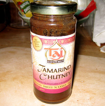
The highly regarded tamarind curry that I had been using seems to have been tossed in a spasm of refrigerator cleaning out, and there wasn't any of the old and only somewhat effective stand-by (peanut butter), but a careful search of a hidden corner of the fridge produced this jar of tamarind chutney. And not just any tamarind chutney, but "Sweet 'n Tangy" and with the claim that "One spoonful spells exotic."
And it is terrific.
Though I should be clear that I have not yet tried it, either externally or internally, for my hamstring/butt/hip issues. Though maybe I should. Although it really looks quite awful.
No, what it is terrific for has to do with the fact that the nights are getting colder, and those little four-footed critters are making their presence known in the house again. And just a little dab of the TC on the trap -- no need for a whole spoonful -- and it works like magic. None of this coming down in the morning to find the bait licked off but the trap still set, and the sense that you will always be on the losing side of the battle between mice and men. Nope, 2 for 2 last night, 2 for 2 the night before that, and 2 for 2 one night a week ago. Magic.
Monday Nov 10, 2008 #
nautilus 40:00 [1]
biking 29:28 [3] 8.4 mi (3:30 / mi)
Sunday Nov 9, 2008 #
road running 9:30 [2]
shoes: Asics trail
road running race 1:38:32 [4] 13.1 mi (7:31 / mi)
weight:141lbs shoes: Asics trail
Oof. A lot of hard work, pretty much done for after 5 miles (or less), a lot of gritting the teeth to keep going. One of those days. Good for building character.
It wasn't the weather, mid-50s and overcast, just right. The legs weren't great, but they didn't seem awful either. The suspicion is that the problem lies with the G, much too much eating recently, and on a day like this, and a course like this, the bill had to be paid.
The course was not easy, lots of hills, uphill right from the start, reached the high point at about 8 miles and then lots of downs the rest of the way.
Splits: 7:47, 7:40, 15:06 (missed 3-mile marker), 7:56, 7:58, 7:57, 7:35, 7:01, 7:21, 7:06, 7:20, 7:44 (last 1.1). 38:29 for the first 5 miles, 37:53 for the next 5 miles, 22:11 for the last 5 km.
Aches and pains -- left hip/butt (something is wrong, maybe just the early stages leading to a hip replacement down the road a ways, maybe not), lower back was sore at times, better at the end, quads just felt beat the whole time. But knees, hamstrings, calves, big toe were all mostly ok.
Willpower was excellent. As was deep breathing. :-)
Results.
Saturday Nov 8, 2008 #
Note
They have been many times over the past couple of decades in the orienteering world when it could also be said, if you needed help with something, go to JJ. Like father, like son, and I mean that in the very best of ways.
Gail came too, also Charlie and Rhonda, also Barb. Saw some cute pictures of JJ at a very tender age. Very glad we went.
Friday Nov 7, 2008 #
biking 1:42:11 [3] 30.4 mi (3:22 / mi)
Legs felt pretty energetic after the day off yesterday, definitely noticed the difference. And the soreness is definitely disappearing, including the big toe which was unhappy for several days.
Rogaine coming in 8 days. I'm quite psyched. First, I have awesome teammates, Kissy, Peggy, and Barb, to which adding me will decrease the average IQ (substantially), increase the average height (modestly, I think), and reinforce the overall sky-high gorgeous quotient. I will have to be on my best behavior.
Second, we have an outstanding team name, thanks to Kissy, namely "At One With Nature" I like it. I really like it. :-)
Third, I have done 23 rogaines, 13 of them the 24-hour variety, but none of them with rules like this one. Plotting the points using UTM coordinates, 4 different quadrants, mandatory gear including a trowel and a knife. We are clearly going over to the dark side, the land of AR folks. Be careful, we may be quite different when/if we return.
Thursday Nov 6, 2008 #
nautilus 35:00 [2]
But enough aches today to think that passing on a run was a wise move.
Wednesday Nov 5, 2008 #
Note
The route. I started at Tully Lake Campground, southeast corner of the map, and headed off north.
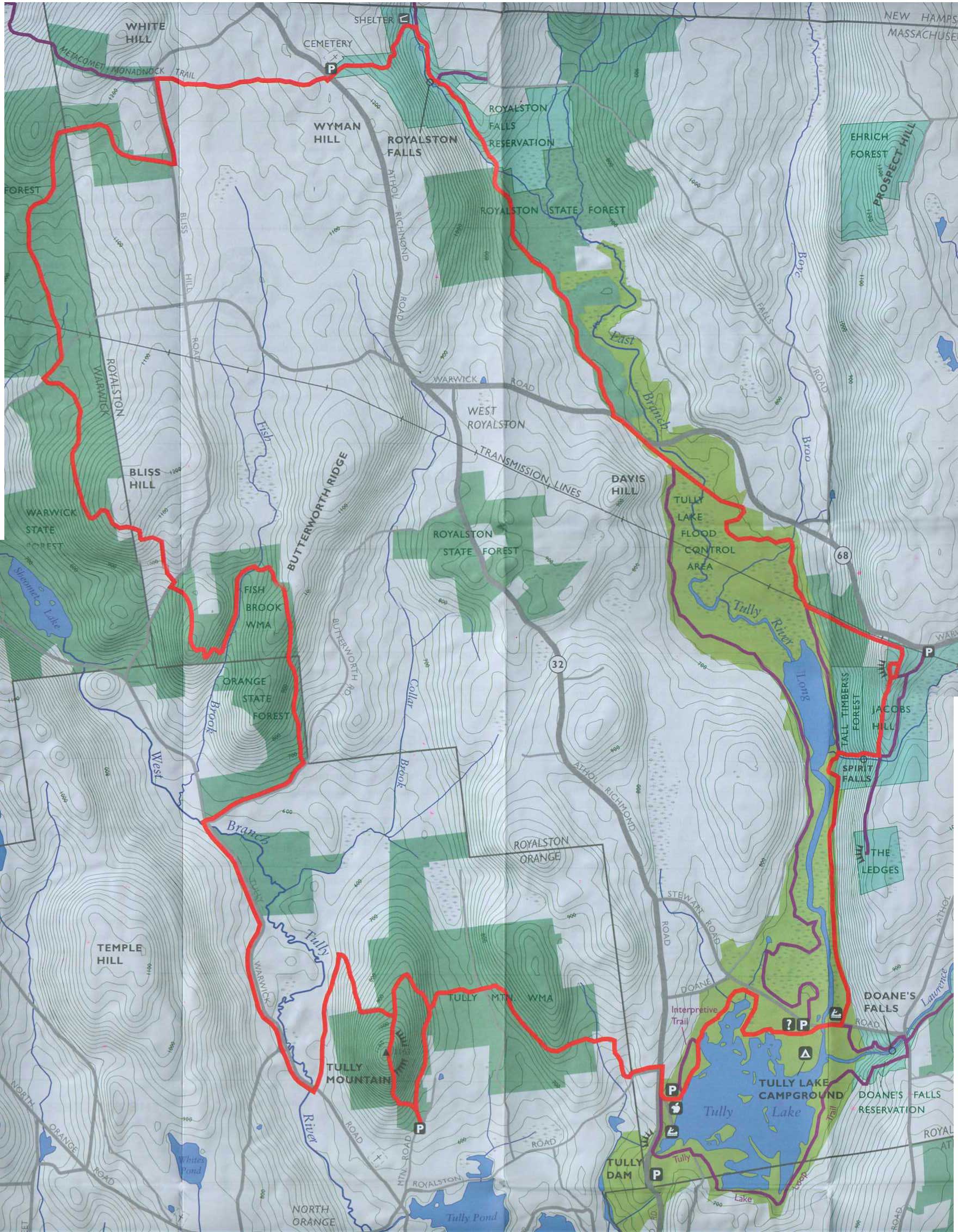
I had with me the trail map, the write-up of the trail in the AMC guidebook to Mass. trails (2004 version), a bottle of Powerade, a food bar, and my cell phone. The map said the trail was 22 miles. The guidebook with it's detailed description of the trail over four pages said 18.4. I figured the guidebook was more accurate. And I guessed that I could average 5 miles an hour, meaning about 3:45 for the whole thing. And it was a beautiful day, not too warm, not too cold, sunny. And the trail crossed enough roads that if I needed to cut it short, I could. So I set off with no worries.
Which lasted for maybe a couple hundred yards, when I realized that the legs, once I got a little oil in the joints, were still feeling the effects of Sunday's race. Hamstrings a little sore, big toe a little sore, and not great energy. But I figured, give it a while, things might get better.
The trail was marked with yellow paint blazes on the trees, sometimes reasonably new, sometimes very faded. And in early November, the leaves were just about all down, obscuring the footpath in many places. The first bit north was an old woods road, fine, but on the climb up along Spirit Falls through hemlock woods, so no leaves to obscure the path, it still was hard to see, had to keep looking for the blazes. It was clear the trail didn't get a lot of traffic. And this was on the part that should have been popular.
Over Jacobs Hill, had to search for turns two or three times, then down along the power line, where the guidebook said the trail was rough and hard to follow. They had that right. Stopped several more times to figure out what was the trail through the high brush, what was just an animal track. But I managed. And then the next section out to Warwick Road, route 68, was good. Got there in 54 minutes, but it was only 4 miles according to the guide. Maybe I had wasted 5 minutes at that point on the route finding, but that was still not good, pretty slow.
Pretty good trail all the way to the bridge over Falls Brook, ran it all, 5.4 miles now, that section took 18 minutes for the 1.4 miles. Legs still felt like crap, and I clearly was moving a lot slower than I hoped.
Next section, up to Royalston Falls, rough pathway, many small ups and downs, 0.4 miles to the falls. The trail was almost invisible, the blazes hard to see, come to a blaze, sometimes I'd see the next one, sometimes not. Took me almost 15 minutes. Yikes. Then a little further upstream, crossed the stream on an old bridge, now an old woods road up to the parking area, still lost it once. Got to the parking at 1:40, 6.5 miles, yikes, not even 4 miles an hour.
Onward. heading west now, over to Bliss Hill Road, now the trail was getting seriously hard to follow as there wasn't even a handrail like the stream going up to the falls. Run 50 yards, stop and look to see where to go, repeat. In many places no sign on the ground of a trail. But I managed. And I was thinking, it's lucky I've spent a lot of time in the woods because I could be seriously lost.
Along Bliss Hill Road a bit, then a couple of miles of old woods roads, made good progress and running ok even though my legs still felt awful, and then a left turn to head up Bliss Hill. Old woods road at first, ok, then petered out, I suppose one could say to a foot path but really just a series of blazes. I was keeping my eyes open as best I could, looking behind me for possible blazes visible going the other way, still many times just stopped, which way now, until I spotted another blaze. And of course a few false starts one way or another.
But managed, just slow progress. Over Bliss Hill, down the other side, took my one fall, steep section, tripped, head first, no damage, but then my left quad started to hurt like it was cramping up, especially going down the steep hill. Shit. One more issue.
Up along Fish Brook, cross an old bridge, over Butterworth Ridge and down the other side and the trail was, if possible, even harder to find. Pretty open hardwood forest, lots of leaves down, most of the time absolutely no sign of a path and the blazes were all faded.
But managed again. Out Butterworth Road to Tully Warwich Road, end of section 2 of the guidebook, 6.7 miles, 3:25, or 1:45 for the last 6.7. Still worse than 4 miles an hour. But just 5.2 to go, and the first 1.5 is on paved road, and the last 1.3 is flat, so maybe just over an hour. Finished off the last of my Powerade and headed down the road.
Ran the road section ok, 13 minutes, then back on a flat woods road for a bit before heading up Tully Mountain. Walked that, trail easy to follow, just took a while, then left at the junction just below the top to take the short way back. Trail seemed better now, more blazes, cruised down the hill, cruised some more, looking for the major junction, cruised some more, shit, hadn't seen a blaze for a bit, went a little more, came to a junction, no blazes of any sort. Damn. Headed back, maybe 3 minutes, spotted a blaze off to the side, trail hard to see in the hemlocks, and the tree with the two blazes marking a turn was lying on the ground. Still should have seen it....
The delay made me aware that the afternoon was getting on and that it would be dark by 5 pm, and sooner in the hemlocks, and it was now about 4 and still a couple miles to go. Best not screw up any more, I thought.
And I didn't, though the last section before I got back to the lake was really hard to follow again. Finally got to the lake, a little over a mile to go, ran it all but probably pretty slowly, and very very glad when the campground and my car came into sight.
Overall, an interesting afternoon. A lot of times I could have gotten seriously lost if I'd been foolish. Also a lot of beautiful woods. And almost 5 hours out there and did not see a single other person.
biking 48:31 [3] 13.6 mi (3:34 / mi)
Good ride, legs felt ok, modest effort. Running would have been another matter entirely.
Yesterday: 1/6 (y), just not up to multi-tasking last night, watching the returns took all my attention.
Tuesday Nov 4, 2008 #
yoga 1 [0]
And then voted. A historic day. Never in my life have I been so eager to vote, and so nervous about the outcome.
trail running 4:50:24 [3]
shoes: saloman
Note
Monday Nov 3, 2008 #
nautilus 40:00 [1]
Started on the blueberries, need to get the eye yoga going too. Figure it can't hurt.
Saturday and Sunday: 1/6 (y), not good.
Sunday Nov 2, 2008 #
road running 17:17 [3]
shoes: Asics trail
At least I planned a decent warm-up. Back out to the 4-mile mark a little bit of a round-about way, then from there to the finish, at a pace that felt like I was straining a bit, and the watch showed 7:50 for the mile. That was not encouraging. Then 10 minutes to pee and stretch a little and get set to go.
road running race 34:21 [4] 5.0 mi (6:52 / mi)
weight:140lbs shoes: Asics trail
Started and felt pretty good, certainly better than during the warm-up, very surprised to do the first mile, totally flat, in 6:52. Still, my pessimistic state of mind did the math and figured 4 more miles at 7:30 pace and I'd beat 37 and that wasn't so bad. Although the last time I ran the race, 3 years ago, I did 33:25. Then a couple of little uphills, not much, but I seemed to cruise up them pretty well, mile 2 in 7:10. Another nice surprise. And I was slowly passing people, and not getting passed by anyone.
Mile 3, totally flat, seemed like it was getting to be harder work, and the split indicated that I was going slower too, 7:07, but still, 21:09 for 3 miles, pretty good. And I was really working on my breathing, every time I seemed to be breathing too hard I'd remind myself to breathe with my belly and not my chest and that felt much better. And still passing a couple of people.
Mile 4, flat then a little down then a little up then a little down. Was slowly passing a guy I knew, pushing a little more, then ran the little up perhaps too hard, really had to concentrate after it on breathing and relaxation and form to keep the momentum going when the body was sending out signals to slow down. But the the split was 6:32. WTF? Was #3 too late? Who knows. But 4 miles in 27:41 and under 35 was possible.
Mile 5, a little down and then flat, no one close in front or behind, the guy in front was 120 meters ahead at one corner (paced it to keep my mind on something else than how I was feeling), still 120 at the last corner. And before long it was done, 6:40 for the last mile and 34:21. And It's a pretty accurate 5 miles.
So very pleased. I thought the slowdown from 3 years ago would be a lot more. And I haven't forgotten how to hurt. Though to keep things in perspective, it wasn't too many years ago that I ran a marathon at a pace about 5 seconds a mile faster. The only way I was going another 21 miles today was in a car.
Won a 5-pound bag of potatoes and a case of PowerAde for my efforts, first really old guy. :-)
The course.
trail running 9:14 [2]
shoes: Asics trail
Saturday Nov 1, 2008 #
trail running 5:00 [3]
shoes: saloman
orienteering 56:16 [3] 5.3 km (10:37 / km)
shoes: saloman
I had a decent run, one bad control, a couple of minutes, and maybe another minute total on a couple of others. Wasn't moving great, legs a little less than fresh, but still would have taken a clean run to be 10 minutes per km. Which was about what I was doing last fall. As I said, not a fast forest.
My routes and a few comments --
.jpg)
Note: Master maps and pin punching today, but an interesting forest (i.e. if you can't have everything, a good forest easily beats high tech).
3. Too far left leaving 2, and then couldn't convince myself to go look where the control was until I'd spent quite a while circling a very small area. 3:20 for a leg less than 100 meters. :-(
8. The "crossable" marsh looked totally unappealing (deep water, green slime...).
9. Past the edge of the knoll, southwest, after a bit saw the control way back to my right. There was no clear end of the marsh. I actually stopped for a moment after I punched to check the bearing back to the knoll and it was due east. So something was a little fishy, but no big deal.
10. Quite thick in the last 100 meters, also lots of rock, all sorts of boulders almost big enough to be mapped. Getting confused, saw the cliff, found it on the map and was ok. Lost maybe 45 seconds.
11. Caught up to a guy in a red hat, punched together, never saw him again.
12. Moving much better, visions of a guy in a red hat beating me to the control.
14. Trouble reading the map as I started down the last steep hill. I remember thinking, just go down a couple lines from the bottom and figure it out. Got lucky, spotted the control right ahead of me when I couldn't have said exactly where I was.
15. Little teeny knoll just before the last up told me right where I was.
16. Moving really good, passed Hans Bengtsson, patron saint of NEOC, sort of knew where I was all the time, back in control at the end and spiked it. And then in.
Thanks to Bob Lux and the UNO folks for a nice day in the woods.
trail running 25:09 [3]
Map is hard to read on the run, even when on trails. I can pick out some stuff, but not very well. The eyes are fading. I suppose I should be doing exercises for them too. Eye-yoga?
Note
Yesterday: 2/6 (yc), need improvement.
Tomorrow: No orienteering, drove enough today. Plan is either a 18.4-mile trail run (distance according to the guide book, not the website) or a local 5-mile road race. Haven't decided which, and doing both is out of the question.