Training Log Archive: PGIn the 30 days ending Jun 30, 2010:
| |||||||||||||||||||||||||||||||||||||||||||||||||||||||||||||||||||||||||||||||||||||||||||||||||||||||||
| « | » |
| » now | ||||||||||||||||||||||||||||||||||||||||||||||
| Tu | We | Th | Fr | Sa | Su | Mo | Tu | We | Th | Fr | Sa | Su | Mo | Tu | We | Th | Fr | Sa | Su | Mo | Tu | We | Th | Fr | Sa | Su | Mo | Tu | We | ||||||||||||||||||||
Wednesday Jun 30, 2010 #
hike 18:00 [1]
shoes: saloman
Started out with a lengthy drive over to Glacier Point, wonderful panoramic views of the park....

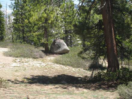
Next the actual "training" -- an assault on Sentinel Dome (route).

I must point out that of all the peaks climbed during the weekend by various folks attending the wedding, I belief we can claim the highest, a little over 8K, certainly higher then the assault that Ross and Alex and others made on North Dome that took them 9 hours. Our round trip time was about 45 minutes, including 15 minutes or so hanging out at the summit. Though I suppose they did start a little lower.
It was actually pretty cool. Neither of us was interested in anything strenuous, but the dome was there and wanted to be done. Found a spot as close as I could on the road, figured we could bushwhack over, and lo and behold there was an old road going right where we wanted. Not that the bushwhacking would have been hard, the terrain was quite lovely, just waiting for an O' map to be made....


Back to the car, headed for the Mariposa sequoia grove, but first a stop to cool off....


Looked fine, but was it ever cold (notice that Gail has only one foot in). Brought back memories of a day in Alaska 17 years ago, a stream coming right out of a snow field, I offered something tasty (a Snickers bar?) to anyone who could stand in it for a minute, a prize claimed easily by Jim Baker, despite the fact that I took 3 or 4 minutes to count off supposedly one minute. The man has no pain sensors.
And then off again, but soon a quick stop to check out a bear....

And then finally to the sequoia grove, and the trees were really quite something (this is just an average size one)....

And of course the root stock (see yesterday's post) was superb, couldn't help but think of Valerie and her tiny little specimen.
And then on the way back to the car I thought it might be a good idea to see if there were any interesting birds to be seen, and no more than a minute later I heard a little noise and looked up and there was a female black-backed three-toed woodpecker, fabulous.
By now it was getting to be late afternoon, time to check out the main Yosemite valley, the light was now perfect...
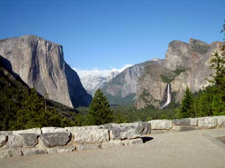
including a short walk to Bridal Veil Falls....

and some more looking around, and then the drive back to Evergreen Lodge where we were staying, just outside the park. One last pleasant surprise, the park fee had been $20, covered 7 days for both of us, but there had also been a sign mentioning a deal for those 62 and older. So I asked on the way out. Yup, $10, and this gave you a *lifetime* pass good to any national park or other facility, plus anyone traveling with you. So I got one of those, plus a refund of $10. :-)
Such a fine day, a side-benefit of the wedding. Glad we had the chance.
Tuesday Jun 29, 2010 #
Note


Note
In the meantime, let's at least publish the results of the event I went to -- Boris and Kat did actually get married....

Monday Jun 28, 2010 #
Note
-- A report on the wedding, with some photos of O' folks in real clothes, including a shot of the possible women's WOC relay team this year looking absolutely fabulous.
-- A couple of bits of legitimate training, one a run, the other an O' sprint.
-- A magnificent day in Yosemite, including significant mountain climbing, white-water video trying to match the epic Jim Baker feat 17 years ago in Alaska, and a new root-stock record by far (just think of one word, sequoia).
-- And some other stuff.
But will it get written? Other things need doing, like plans for when we get to Calgary tomorrow. So just a little preview for now --
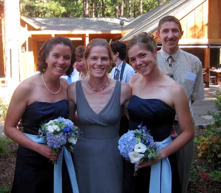
Oh, yes, Balter was looking fabulous too.
Thursday Jun 24, 2010 #
Note
weight:139lbs
And I'm thinking, you don't often run into folks on this continent that remember Yuri Gagarin.
And then he says, "Famous orienteer, long-distance runner, been on the Wheaties box."
I shit you not.... :-)
So we had a short chat, smiles on both faces, he'd done a little orienteering with his kids way back when. And clearly his memory is better than mine these days.
Wednesday Jun 23, 2010 #
biking 1:10:13 20.33 mi (3:27 / mi) +423ft 3:23 / mi
ahr:138 max:158 weight:140lbs
Or maybe it was because of the good karma I had from actually following up on something I'd talked to JJ about a couple of weeks ago, namely, did he know of any places where one could give old bikes to and maybe they could put them to some use, instead of just dumping them in a landfill.
And JJ had sent me several suggestions, all slightly complicated, though one was just to inquire around here at the local shops. I can't say that was exactly what I did -- what actually happened was I was listening to the radio yesterday, local station, not NPR, and on came an ad from a local bike shop, they were having a program this weekend for people to buy/sell old bikes, also for people to donate old bikes and they would be put to use.
And so I swung by the shop yesterday afternoon, yup, they'd take my three old dogs, bring them by on Thursday. I'm away Thursday, how about Wednesday afternoon? Sure, that'll do.
And I managed to stuff all three in the Subaru and deliver them this afternoon and the guy seemed happy to have them ("Ah, Univega's, a lot of these have passed through the shop"), and I was certainly happy to be rid of them in a good way.
Tuesday Jun 22, 2010 #
Note
I'm setting courses for a local WCOC meet Sunday, September 19 at Sessions Woods. It's the weekend for national O' day.
I've heard folks talk about how we might benefit (something new for experienced orienteers, or something enticing for newcomers) from allowing or even encouraging participants to use a GPS. I thought it might be interesting to try.
Has anyone done this? If so, what did you do, and how did it work out?
I assume one way would be to just give the coordinates of each point as part of the control description. I would think this would be the most helpful.
Or, you could put a UTM grid on the map, let them plot their own coordinates as needed (beforehand, or real-time?).
Or, maybe for experienced orienteers, just make it explicitly OK to use a GPS and see what they come up with.
Or something else?
Any thoughts? It would be nice to try something out. And maybe a way to attract a few more people without any significant extra workload. (Or maybe it would be a significant extra amount of work?)
Just wondering....
Monday Jun 21, 2010 #
biking 1:41:28 25.81 mi (3:56 / mi) +1355ft 3:45 / mi
ahr:133 max:161 rhr:56 weight:139lbs
Sunday Jun 20, 2010 #
Note
OK, let's be truthful, to see if Valerie could. She missed by about 20 minutes. I'm not sure how much of that was mistakes (my guess is quite a bit), a combination of mistakes and just not executing well and quickly, standing and thinking too much instead of doing all that thinking on the move.
I'd guess I had at most 30 seconds of such wasted time, partly due to not having controls out there so approaches had to be a little more precise to be sure I had the right spot.
As far as how fast I was moving, I'd suggest comparing it to my time up the road, 18:40 for a mile uphill with excellent footing. The perceived effort was about the same as throughout the course. But I should point out that my effort was pretty constant over the whole course, moving just as quickly at the end as at the start. My guess is Valerie was fading.
On the other hand, she could go at a pace 45 minutes slower than what I did and still make it. That ought to be doable.
At least with a good guide.... :-)
Today's routes.
QR.jpg)
orienteering 2:43:28 7.18 mi (22:46 / mi)
shoes: x-talon 212 #2
My navigating was right on, though it is a lot easier when just walking, lots of time to both look at the map and look around in the terrain. A few comments about some legs --
1. Stayed up on the hillside on the first part, figured it was shorter. Not sure it was faster though.
3. I'd heard folks complaining about a control in an area not field-checked. f you have any O' skills at all, you shouldn't miss this one, a good-sized knoll on a steep hillside. Should never miss it. And if you've ever orienteered on not-so-good maps (or rogained), you wouldn't be worried about it either.
4. Here as on several other climbing legs (6, 10, 13, 14, 17), my time walking was just as fast as my time a month ago racing. Of course I was just walking then too.
7. Tried a different exit from 6, back and then right. Not sure it is better walking, but would have been better racing. Stick in the eye approaching the control, hurt pretty good.
9. A better route, a little left, picked up the ride by the depression and the control was simple and fast.
11. A little farther right (and better) than before.
19. Cut straight down through the woods. Don't think it was any better, though I think it might be for someone more coordinated.
20. Higher (slightly more left) line, better I think.
23. Took the left fork since it looked shorter.
My routes from the race.
QR.jpg)
My routes from today (coming).
Oh, and it was hot and humid, soaking wet by the end. I'd left a bottle at 12, just drank half of it. Lost my usual 5 pounds or so.
Heart data from the last half hour or so is bogus. Max was about 140. FDF count was about 10, plus lots of twigs.
orienteering 18:49 [2] 1.01 mi (18:37 / mi) +358ft 13:57 / mi
shoes: x-talon 212 #2
Saturday Jun 19, 2010 #
Note
Anyone care to predict?
biking 1:55:06 31.03 mi (3:43 / mi) +630ft 3:38 / mi
ahr:132 max:159
biking 39:14 11.33 mi (3:28 / mi) +43ft 3:27 / mi
ahr:128 max:142
Down through Amherst, around the Holyoke Range, and back through Hadley. Nice tail wind coming back, needed it, though I paid for it a bit on the way out. Legs were tired by the end. Need to drink more, just drank about half a bottle and my weight was down 5 pounds.
Friday Jun 18, 2010 #
biking 1:12:08 20.29 mi (3:33 / mi) +364ft 3:30 / mi
ahr:130 max:159 rhr:54 weight:139lbs
Just a nice steady pace, not pushing it. Ten seconds a mile makes a big difference in the required effort. This seemed very comfortable except for the couple of hills coming back River Road, but just a little faster would have taken a lot more effort.
Looking closing at the elevation profile, it's pretty accurate except for at miles 1.3 and 19.0, where it doesn't seem to account for the fact that there is actually a bridge across the Connecticut River.
Thursday Jun 17, 2010 #
Note
I noticed that while on most runs/rides, AP is automatically calculating the climb, on Tuesday's bike ride it didn't. So I sent a note to Ken inquiring if I was messing something up. And his answer --
"The service that I'm getting the corrected elevation data from has a daily point limit per user. Unfortunately it's pretty easy to run into the limit with a normal long session, and then the correction fails. In that case we also don't calculate the climb since it could be way off.
I either need to find a better data service for this or create my own, but in the meantime, there's nothing that you should be doing differently."
Wednesday Jun 16, 2010 #
trail running 31:11 3.37 mi (9:15 / mi) +282ft 8:34 / mi
ahr:137 max:156
Better than it will be in the future, I suppose.
Tuesday Jun 15, 2010 #
biking 2:22:53 38.08 mi (3:45 / mi)
ahr:141 max:157 rhr:56 weight:138.5lbs
A beautiful morning, some nice back roads, and quite a lot of hills. And I sure did some work. Mainly because he is just a little stronger than I am, so it was always a bit of a struggle to keep up. I could keep up, but I had to work at it. Also had to drink a lot more than usual, think I took 5 or 6 sips. Started with about a third of a bottle, now it's down to a quarter. Still probably enough to get a couple more rides in before I have to refill it. :-)
By the way, Eric Buckley would love Northampton's streets. Potholes everywhere.
So counting yesterday late afternoon and this morning, that's a little over 60 miles in not that long a time period, and the butt (and the hands and the neck) are not really complaining. Not so bad!
Note
And since then my distance vision has gotten worse, the acid test being on the golf course where seeing a ball 100 yards away is usually beyond me.
And at the last appointment there had been mention of cataracts, not serious yet, but starting.
So some anxiety.
First thing, I complain about my vision. He puts up a chart and I'm struggling with the second line, and those letters are pretty big! So he put some gizmo up in front of my eyes and asks if that is any better.
Holy shit, yes! Well, maybe I didn't say exactly that, but suddenly I could read a couple more rows. And that was really cool, because maybe on the golf course I'll be able to do more than just see what direction the ball is starting in and then go try and find it.
So that was the good part.
But of course he had to examine the insides of the eyes, and things are a little off (a sheen on the retina, the optic nerve entry point is enlarged), maybe a sign of not so good things to come, maybe not. But the pressure is good (i.e. not high), and that's good as far as glaucoma is concerned.
Nothing serious enough to do other than say come back in a year. Could be worse.
And we're about finished, and I ask him how old he is because I'm wondering if he'll still be taking care of me for the next few years. And he says he's 55, but he figures he's going to be working forever, because he's supporting his ex and the two boys who are living with her, and he doesn't have any retirement savings. He's not bitter, just very matter of fact, he grew up in a family with 8 kids and you never got anything new. So he can manage now on not so much, certainly get what he needs even if not so often what he wants.
Interesting little conversation, a glimpse inside someone else's life, totally out of the blue....
And then off to the optician, a client of mine, order the new lenses, they are quite complicated and not cheap, various corrections for this and that, and he will put a rush on them so hopefully I will get them before we head west.
And then home, and another short nap, and then I can't put it off any longer, it's time for the first mowing of the "lawn" for 2010.
Yes there is a little gas, maybe it's stale but it should work, fills up the tank about 2/3. Push the little primer thingy to get some gas wherever it needs to be to start the engine, but the little primer thingy doesn't seem to be working, a leak or something. Yank the cord a few times just in case. Nothing. Damn.
So I think, what would Jeff do? Jeff sure wouldn't put it in the car and haul it off someplace to be fixed. Jeff would fix it himself. And I looked at the machine, not much idea what any of the parts were, but on top of the part above this little primer thingy was a screwhead. So I pulled a penny out of my pocket, and unscrewed it, and this long screw came out, and then this superstructure came off, and under that was this little container. And it looked like that was where the little primer thingy would deliver some gas to get the engine started.
So I got the gas can and wiggled it this way and that and enough gas game out to fill up this little container about half way. Put things back together, pulled the cord once and it started right up. Son of a gun, I am not totally incompetent.... :-)
Ah, but still somewhat incompetent. The "lawn" got cut, but in the process I converted a perfectly nice 50' hose into 3 somewhat less useful hoses, two of them averaging about 24.5' and the third about a foot long.
These sorts of things just seem to happen to me. I really don't think there is anything I can do about it.
Monday Jun 14, 2010 #
Note
rhr:57 weight:139lbs
-- I enjoyed the opportunity to meet and chat with several members of the Board who I hadn't known. I also enjoyed seeing a few old-timers some of whom I've seen regularly over the years, some just every once in a blue moon. We have some extraordinarily fine people in the club.
-- It was mentioned at the meeting and it bears repeating, the club's new and improved website is really great. By yesterday evening the results from yesterday's O' event and the results of the elections (plus the new board's officers) were already posted.
The website is a great way of communicating with both members and non-members. So I hope it continues to push forward, both in ways that would bring more visibility to what the club is doing internally, and also by getting info up sooner about things like the club's upcoming A meet in October. Many folks didn't even know about that, and its only a few months away.
-- There was some unnecessary nastiness, but the person responsible is now gone. There is nothing to be gained by retelling it. It's time to move on, and focus on all the good things that are in the club.
biking 1:32:06 [3] 25.06 mi (3:41 / mi) +886ft 3:33 / mi
ahr:138 max:155
It was also a ride where the activity should more properly be call "bike-logging" rather than "biking," because much of the time was spent thinking about things I might write on my log. And that is also good and bad, good because I found myself reaching the top of a hill without any memory of having put in any effort, and bad because I found myself reaching the top of a hill without any memory of any of the bad things out there, like potholes, or storm drain, or traffic. Not a good habit to get into, but the miles sure do go by easily.
More coming, but first a tax appointment is calling.... :-(
Note
And I added a comment to Jeff's log, something that needed saying. I've met a lot of fine people in orienteering and that family is right at the top.
Sunday Jun 13, 2010 #
Note
.jpg)
QR.jpg)
.jpg)
Note
Film at 11.... :-)
Note
QR.jpg)
And here's today's outing at Monotomy. Not real interesting, but it is a neat little park.
QR.jpg)
orienteering 35:23 2.74 mi (12:56 / mi) +171ft 12:13 / mi
ahr:143 max:159 rhr:58 weight:140lbs shoes: saloman
So I ran for about 15 minutes, did a moderately hilly loop around the little park, lovely woods, had my map from stage 5 (the chase start) of the Rt. 128 O'Ringen in June 1992, 5 events on 5 different maps all in one day. Running around the place with the old map brought back some nice memories.
And I was also noticing a lot of O' flags, and almost nobody orienteering, because it was now picnic time. So I swung by the finish, confirmed that everyone was done, and then went out and picked up one of the "no trails" courses, and then the White course. Hard to carry more than a few of the stands at a time, but this is a small area and it all went very quickly. Very good fun and nice to feel a little useful.
And the feet weren't too bad and I ran up quite a few hills! :-)
Saturday Jun 12, 2010 #
Note
And then finally the club meeting, run masterfully by President R. DeWitt. The fall schedule was filled out within 15 minutes, Treasurer Jim took about 30 seconds for his report, there was a brief discussion about our options to the northeast -- should we make a leveraged buyout offer for NEOC, or should we just wait until it implodes and swoop in and pick up the pieces, or should we just open up a WCOC Boston chapter. So many good choices! I believe the first step may simply be to show up at the NEOC meeting tomorrow with a bunch of WCOC membership applications.
And by now the meeting was clearly over, but there was still a lot of dessert to be dealt with, and stories to be told, and laughs to be had.
Such a fine club....
Thanks to Charlie and Rhonda once again for their wonderful hospitality.
orienteering 17:17 1.3 mi (13:18 / mi) +135ft 12:07 / mi
ahr:140 max:155 rhr:56 weight:138.5lbs shoes: x-talon 212 #2
I'll put up the map, but probably not tonight.
orienteering 30:18 1.93 mi (15:42 / mi) +154ft 14:36 / mi
ahr:141 max:166 shoes: x-talon 212 #2
Friday Jun 11, 2010 #
biking 1:28:15 23.78 mi (3:43 / mi) +653ft 3:37 / mi
ahr:130 max:151 weight:139lbs
It is clear that I am now in the easy part of the plan.
It is also clear that I better get to it, because the 5-week period includes a two-week break for weddings and other foolishness.
Hmmm, it seems also clear that the century may well suck. Can't wait!
Oh, and today, a nice ride, back roads in Deerfield, a couple short steep hills, and there was actually a little energy in the legs at the end. I attribute that to the couple sips of water I took along the way. :-)
Thursday Jun 10, 2010 #
trail running 19:15 1.91 mi (10:05 / mi) +144ft 9:24 / mi
ahr:141 max:160 slept:7.5 weight:138lbs shoes: saloman
Most definitely out of shape, but better to be doing something. The plan is to try to run 2 or 3 days a week so that maybe I'm just slightly less feeble at the North Americans. And then bike the other days. Today was planned for a run, plus it was raining, and I try to avoid biking in the rain.
Two 2's today on my walk and under 80, neither one common. Enjoy it while I can.
Wednesday Jun 9, 2010 #
Note
Note
"I don't need no GPS, just give me a map."
-- Louis, the main man of the pair delivering a new washing machine today, very cool, very together, very black (not that that matters), and very pissed that they sent him off into "the mountains" (i.e. Sunderland and neighboring towns) with a really big truck, and no map, and some places where the big truck can't go because a bridge is out or an overpass is too low.
He checked in with the office as soon as he got here, he'd be out of here in 6 minutes he said, then we spent the next 10 minutes laughing about his adventures in the mountains. Wanted to offer him a beer and have him stay for a while, tell some stories, but he did have more deliveries to do. He sure seemed to know what he was doing.
And as for us, well, delivery was supposed to be between 3 and 5, after which we'd head out for the annual anniversary dinner someplace. No sign of anyone at 3, no sign of anyone at 4, about 5 a woman called, they're running late, will be there 5:45 to 6.
6:00, no sign of anyone, what can we do, the only sure way of having them show up is to start eating dinner, figuring they'll appear as soon as we sit down, so Gail throws together some leftovers (very excellent leftovers I should add), and we chow down. All done after a while, still no sign of them.
Plan B, call the store. Got the manager, seemed pleasant, he'd check, and just about then we heard the truck backing up the driveway, maybe 7:15 by then.
But Louis is so cool, how can you be pissed? And we have a new washing machine (not sure how many decades the old one had served). And we can always go out another night.
biking 1:30:25 23.23 mi (3:54 / mi) +1066ft 3:44 / mi
ahr:135 max:157 rhr:54 weight:137.5lbs
After been severely chastised by Jeff for not carrying any water with me, and for sure 2 bottles and not just one, I cleaned up my act, at least partly. Carried one bottle. I suppose the next step is to actually drink some. (Or is the next step to carry two bottles, and then the next step after that to actually drink some? It's all so confusing....)
Tuesday Jun 8, 2010 #
Note
trail running 16:59 1.79 mi (9:30 / mi) +72ft 9:09 / mi
ahr:141 max:157 rhr:55 slept:7.5 weight:137lbs shoes: saloman
Short and flat, felt hard. Glad it wasn't a 5K, not sure I could have finished.
Monday Jun 7, 2010 #
Note
Such as -- if you wake up in the middle of the night and can't get back to sleep, fire up the computer and start up Big Muddy II. You'll be old cold in no time....
Important disclaimer: No animals were harmed in the making of Big Muddy II. Anything dead was already dead.
biking 37:04 [3] 10.0 mi (3:42 / mi)
weight:137.5lbs
Jeff has got me interested in doing the Climb to the Clouds with him and Judy. Foolish? Perhaps, but certainly less foolish than doing the Greylock century again. And it would give me something to look forward as we approach the dog days of summer.
Note
And it reminded me that I was supposed to have a Chekhov story read to me in Oregon, but somehow it got forgotten about. Maybe it's still in the future. In the meantime, I think I should investigate the local library to see what they have of his. I don't think I've ever read any, and he is in my heritage.
Sunday Jun 6, 2010 #
Note
A higher-resolution version is at Barb's log.
The reviews are already coming in. This one is typical --
"A major step forward in the new "rogaine reality" genre. Brilliant. Two thumbs up, way up." -- Roger Ebert
Though there are always the exceptions --
"IMHO, it's pretty lame, FWIW" -- man on the street, possibly known as Randy.
And then from the comments on AP --
"Clearly Academy Award material in several categories, included best director, best cinematography, best actor, best original script, ... best actress ... too."
The sequel has already been shot and should be appearing soon.
orienteering 1:13:33 4.95 mi (14:52 / mi) +344ft 13:56 / mi
ahr:149 max:162 rhr:56 slept:9.0 weight:137.5lbs shoes: x-talon 212 #2
On the plus side, heels seem to be better. Not sure if good enough that I might actually have to start doing some training, horrible thought that that is....
The map and my route. No problems, except I'm walking (and not very briskly) every time the route isn't full green.
QR.jpg)
Saturday Jun 5, 2010 #
biking 2:06:44 31.22 mi (4:04 / mi)
ahr:135 max:159 rhr:56 slept:8.0 weight:138lbs
Hot and humid. I suppose it would have been a good idea to take along something to drink. Weight dropped about 4 pounds.
Friday Jun 4, 2010 #
Note
rhr:55 slept:10.0 weight:139lbs
Note

And also a runner-up --

Well, there is a new entry, this one from Gail, and bearing in mind that perspective is a very tricky thing, it seems quite clear that this one edges out Valerie's for first place.

Or for a larger view.
Note a very important consideration -- we own ours, Valerie just visits hers. :-)
biking 49:21 13.84 mi (3:34 / mi) +299ft 3:30 / mi
ahr:134 max:161
Plus another morning at the office. What gives? This is supposed to be the off-season. But I got another of my least favorite e-mails, from one of my ladies, saying so-and-so called, they got a letter from the IRS, please give them a call.
They are probably freaking out. And of course all I am thinking is that I hope it's not my fault.... :-)
And fortunately it's almost always not. As was the first case this morning. So then it's just a matter of figuring out what's needed (in this case some of the money the client thought had gone into a traditional IRA had actually been put in a Roth), and knock out a couple of amended returns.
And the second case, friend of a client, didn't file at all, didn't think she had to, but the IRS thinks she should have. Will take care of that one too but have to round up some documents first.
Putting a nice dent in the bill for the rogaine trip.... :-)
Thursday Jun 3, 2010 #
Note
-- "Heavy cushion" wool socks worked really well. Felt weird when I first put them on, too spongy, but not a single blister.
-- Had too much food again. Took 4 energy bars and 2 baggies full of trail mix. Ate just 2 of the energy bars and less than half the trail mix. It's nice to have a little in reserve but that's a bit much. Both the bars and the mix have quite a lot of protein and fat, so they last longer.
-- Took half a 200mg caffeine pill a couple of times, once quite early in the night, another not long before dawn. Barb, too. I think it helped. Plus another full pill about 30 minutes after we finished to get me wired for the 90-minute drive back to Madras. Had no problem staying awake for that. Barb, on the other hand, self appointed to entertain me to keep me awake, every once in a while things would be quiet for a minute or two, and then she'd make a little start and say she'd just been off to dreamland and back, for all of 30 seconds or so, and had weird dreams to report. Quite an interesting drive!
-- The battery on the Tesla is supposed to last something like 1.5 hours on high beam, or 8 hours on medium beam, or 24 hours on low beam. What it really needs is something that shows how much power is left. In the absence of that, I was of course conservative, most of the time on low beam, maybe 10% of the time at medium and 5% at high. I assume there was plenty of power left. The beam certainly didn't fade at all.
-- It might be a good idea to try using a trekking pole or two. I might fall down less. It might take a little effort, but I should be able to deal with the resulting self-image problem.
-- Maybe the compass around the neck right from the start would be a good idea.
-- Maybe time to investigate a tow rope (and how it works as the towee).
Hopefully there are still a few more rogaines in my future. They are wonderful adventures, even at a slower pace.
biking 41:10 11.0 mi (3:45 / mi) +233ft 3:40 / mi
ahr:126 max:147 weight:139lbs
I'm assuming at the point the natural fluctuations in life will have me feeling better.
At least I managed to take care of one client this morning, a common situation this time of year, she hadn't filed since 2006. Got all 3 years done, got Mass. DOR to suspend collection efforts for 60 days, and she left quite happy.
And I made a nice dent in my rogaine trip bills. :-)
Wednesday Jun 2, 2010 #
Note
slept:9.0 weight:140.5lbs
Needless to say, she was delighted. I was stoic.
Note
.jpg)
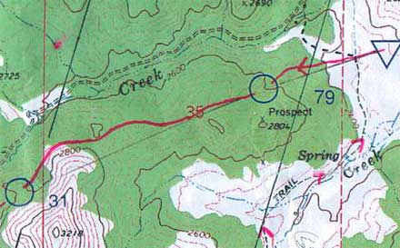
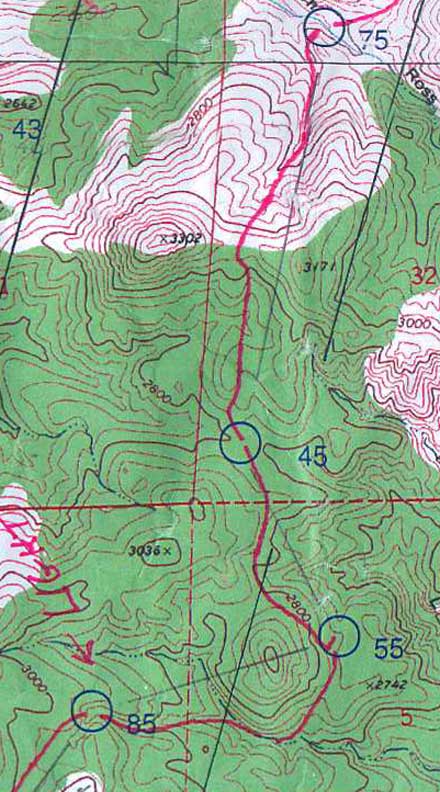
Lots of folks ahead of us going up to 79. And then all by ourselves to 31. Clearly we had a special route. It was also clear pretty quick that the navigation was mostly simple. You could usually see the feature you were heading to from a longs ways away.
First of many pain-in-the-butt climbs. I already knew they would be a struggle. Dropped our packs for a little bit on the short out-and-back to 49. On the long gradually downhill road to 47 we just walked (no plans for running today).
65 was less obvious but not hard, just up the slope a little ways and quite a lot of trees cut the visibility. 57 looked like it might be difficult (the margins between white and green were usually useless), but in the case the open area was very well defined. One of those legs where you pay really close attention and then the point turns out to be obvious. Oh, well, better than the other way around.
83 was just up.
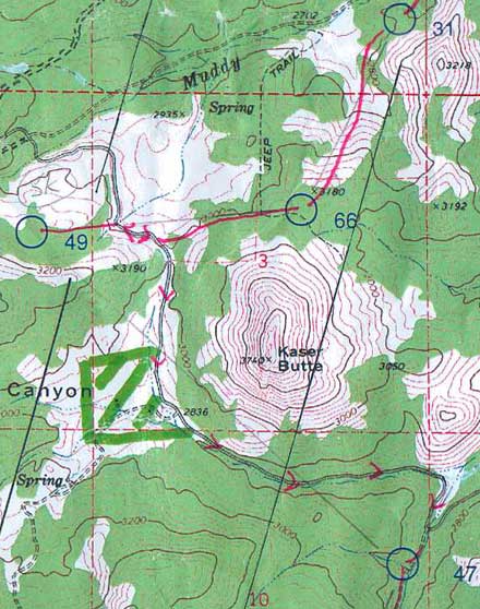
Rough footing on the rocky hillside to 77 but easy navigation.
To 50, I spaced out a little, thought we were going a little straighter and were closer and was getting uncertain, but Barb had things under control. Clue was a rock outcrop, lots of them in the area. Control was on the second one we checked.
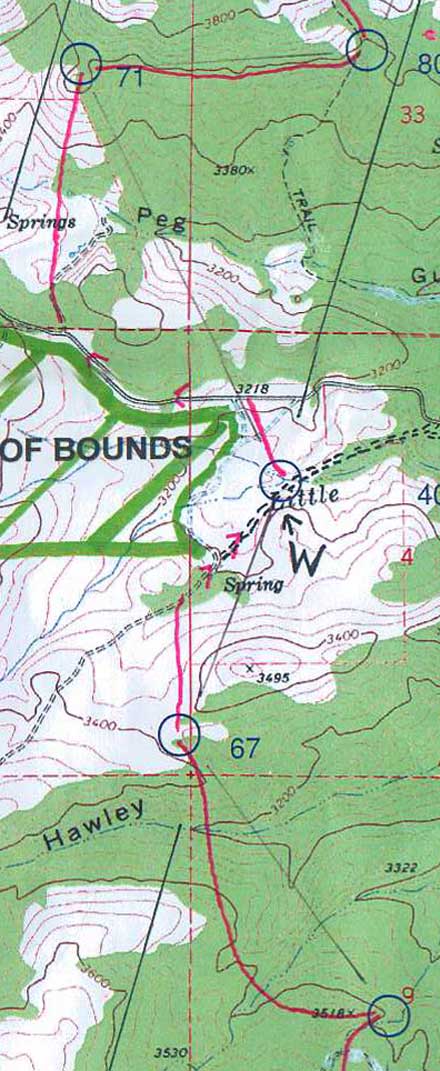
A left swing to 67 to minimizing the steep sidehills, trade them for a steep down and up at the end.
Could see where 71 was going to be from half a mile away, also look across and see where 80 would be.
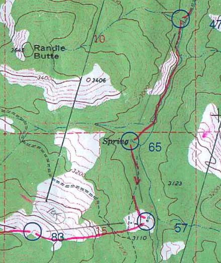
Nice route to 80. Nothing special, just very much in control, picking up the little subtleties in the contours and came out at exactly the right level. Didn't need to, easy point, but good practice.
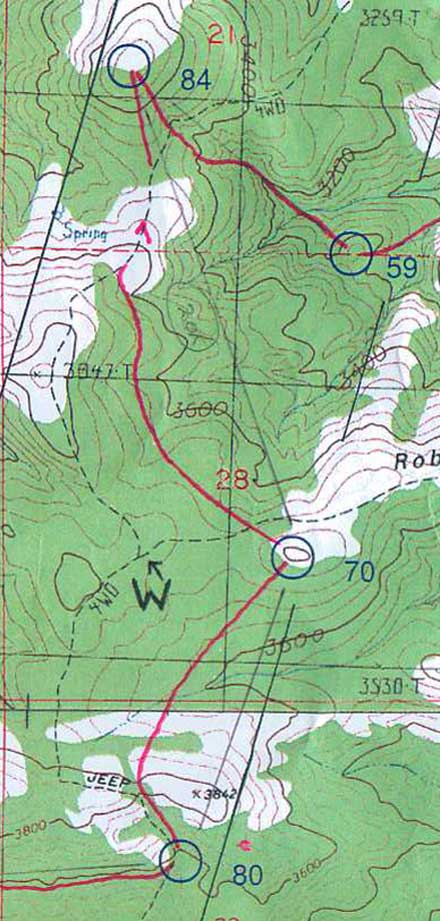
For 70, got over the first ridge, check the compass, yup, there's the hill we're going to.
For 84, check the compass, yup, there's the hill we're going to.
For 59, check the compass, yup, there's the hill we're going to.
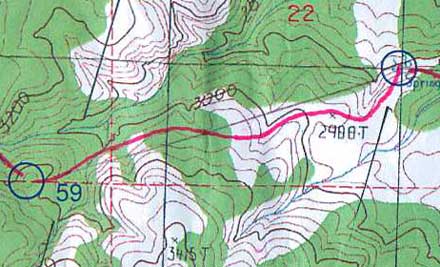
60 was a nice leg, almost wish we could have done it at night. Had to pay attention a little. By the way, we were alone almost all the time in the whole section, just a couple of groups going the other way.
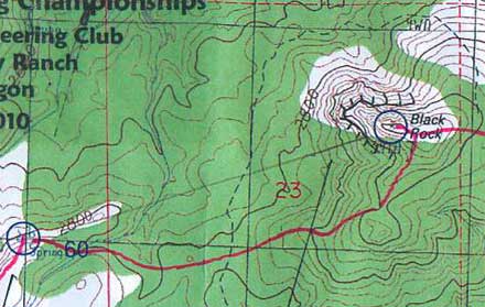
For 72, Black Rock, didn't need to check the compass, it was obvious where we were going. We originally thought we would go up the reentrant SW of it, but it was steep and had lots of outcrops, so we swung a little further right.
Wonderful views in the early evening. Maybe another hour or a little more of daylight. No problems so far.
================================
Continued....
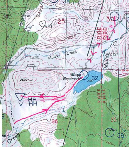
Here's our routes for the eastern half of the rogaine, covers where we were from about an hour before dark to about an hour after daylight (click here for the overall view), plus a few notes....
.jpg)
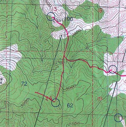
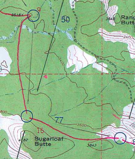
For 62, once again, check the compass, yup, that's the hill.
To 100, a little more interesting, find the correct spur. The sun was down, plenty of light to get to 100, not sure about enough for 52.
Heard voices approaching 100. It was a team of 5, one or two of them females, fairly young, looked very professional, strong, fast, good material for a photo shoot for sure, an AR team I assume. They were going the other way. Didn't actually seem to be moving very fast nor know quite what they were doing, but they did look great.
To 52, it seemed easier to retrace our steps a ways and then contour across, saved a bunch of descent and climb, also easier to find the control. Last bits of daylight, spiked the control oh so nicely, right in front of us as we crested the spur.
Kept going just a bit more toward 78 to get in the correct reentrant, then couldn't read the map any more and stopped to get out the headlights. I was trying my Tesla for the first time on a rogaine, Barb had something different, also very good. And they worked really nice, as we were dropping down towards 78 you could pick up all the side spurs and reentrants, then the little knoll on the left, plus the profiles of the knolls up on the ridge behind 72 were visible. Hit the last hillside just right of the little spur, slid left and there was the point. Nice.
To 63, looked complicated, what the hell, let's just go straight. Down across the bigger reentrant, then generally climbing but dipping through a couple deep little reentrants, then over the flat spur, then down again, everything still matching up, past a couple of reentrants coming down from the left, over a modest spur, across a little reentrant, up on a very small spur, and boom, we light up the control maybe 20 yards to our left.
Isn't this more fun than daytime?
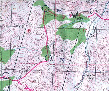
Beat our way through some junky stuff to get to the trail leading to the water drop, nicely timed, I'd gone dry about 10 minutes earlier. And we were talking about the approach to 73, and how there were no nice obvious features, and I said why not just go down the trail until we could see the road and then back in from there. Which was the plan.
Until we had gone a ways and I looked more at the map and said, there are 3 distinct spurs over there and it's behind the second one, I wonder if we can see anything. And flipped the Tesla to high beam and looked over to the left and there was the first spur and beyond it the second.
So we ditched plan A and went straight at it, and before long the third spur was lit up, and we rounded the corner behind the second and lit up the control maybe 75 meters above us. Sweet.
Sweet, yes, except for what came next, worst climb of the whole thing. Crossed Muddy Creek and then up, up, up. Endless. Though of course it did end, and as we popped out on top there to greet us was the just-risen full moon, right in front of us.
In the old days, full moon or not, the old days meaning any previous rogaine I've done, it would now have been a matter of careful compass and pace along the ridge so as to be quite sure to drop off at just the right place to get the control.
The new technique -- go more or less east, yup, can see the bend from a good distance so turn right a little, yup, can see the next bend from a good distance so turn left a little, slowly mosey over to the top of the slope on the right, go a little ways, and bingo, light up the control from about 150 meters away.
It's so cool it just can't be legal, but apparently it is.
Oh, and pace counting, what's that?

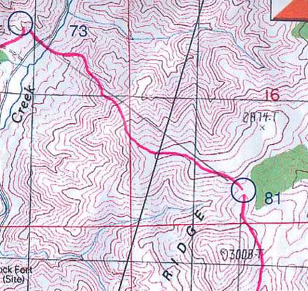
53 was also interesting, across the shoulder of the hill to our south, get in the correct reentrant, follow it down the right distance, and then traverse to get the control. Just as we did, very nice.
Except, it being dark and all, and me being several times more spastic in the dark than in the daylight, so on a fairly regular basis I was just going Splat, and on one of those splats going down the reentrant my compass introduced itself to a rock and that was the end of the compass. Fortunately Barb had a spare, it hung around my neck, I looked just like all the clueless beginners do, but that must have been the right place for it as it survived the rest of the journey.
I will point out that 53 was quite well hidden, we only lit it up from about 50 meters away.
Next to the water, down to the main valley. It had been getting colder, and now seemed even more so, put on all our extra clothes, the valley was probably a cold spot, must have been close to freezing.
A short out-and-back to 74, no pacing, no sweat.
And then life started getting miserable, at least for me. To 69, endlessly up a scruffy drainage, struggling to keep up to Barb, annoying vegetation, regular splats. But the control was right where it was supposed to be (as were all the others we went to).
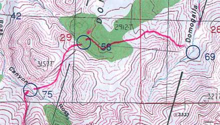
Wrote about 58 a couple of days ago here. A miss but a reasonable recovery.
To 75, first a steep little drop down to cross the drainage. I headed down, she objected, wanted to go around where it was less steep, I persisted, she yelled she didn't want to do it, I persisted, she managed fine but was quite unhappy. I, well, OK, guilty as charged....
Up to the saddle, by now she was once again out front, me trying to keep up. And then down, easy. Saw another team here for just a moment, first folks we'd seen for many hours.
Another miserable uphill. At some point along here Barb told me to give her her fanny pack, which I'd been carrying up to then under the mistaken assumption that I was the stronger of us. Not even a hint of objection from me. Felt nice to be rid of it. Not that I suddenly felt good, just not quite so bad.
The climb finally ended, the order stayed the same, Barb in charge, me hanging on. Over to 45, nice gently rolling terrain, no problem.
To 55, left slope of the big hill, I have a pretty good idea where we went, as I struggled within 50 meters of her out front, cooking away. Was this payback time for the steep slope? :-)
Just slightly too high on the approach, and the reflector was covered by some leaves, had to do a slight turn-back to get it, no big deal.
Off to 85, by now the sky was starting to lighten a little. Went left and up the drainage, miserable again. At some point I asked for a short stop, during which Barb offered to take my pack (so she would be carrying her pack, her fanny pack, and my pack, and I would be carrying nothing). And my male ego just couldn't handle that.
So I refused. And got very slightly pissed. And then it seemed like this perceived insult gave me a burst of adrenaline, because I started moving better. And it was the end of the 50-meters behind, oh I feel awful routine of the previous several hours. So her offer was in fact very useful. The old maxim, what really matters is what goes on between the ears.
Got to 85, climbed out, no need for the headlamps anymore so we turned them off, I put mine away, Barb kept hers on for quite a while. Fashion statement? No, I think it was just her turn to get a little spacy.

Daylight now, perfect timing, got all the harder stuff done at night.
Hmm, 64, a road bend, spiked it!

Hmm, 56, a hilltop, spiked it!

Hmm, 76, hilltop, trail all the way, spiked it, we are good!
A little more interesting to 101, though you could see right where it was going to be. Down to the big saddle, along the slope climbing three or four lines, a nice little saddle.

Down and around to 68, I'm actually leading for once, nicely avoiding the very steep slopes.... :-)
Spiked it, needless to say.
And then 36, an old mine, easy, and 37, a small hill, easy, and we had done our plan and still 80 or 90 minutes to go. Time to pop the question -- do you want to get any more controls?
Sure, she said. Cool. Extra cool. So fine to finish a rogaine in style, getting all you can rather than packing it in early. Not any high-pointers around, it probably would not make any difference in the final standings, but still very cool.
So we bypassed the hash house and headed for 32. The thinking was, if we still had an hour left when we got there, we'd go for 35.
Got there right at 10 am, a hour to go. Started off to 35. A brief conversation, the gist being, is this crazy? We don't want to be late.
Pop the next big question -- do you want to run some?
Sure, she said. Even more super cool. So off we trotted, dropping the packs since we were coming back the same way, ran just about all the way to 35 and it wasn't totally awfully miserable. And we got there so freaking fast, 10:11. A slight sense of how I used to be able to do rogaines.
So plenty of time to get back, ran a bit back to the packs, and then walked the rest of the way, still rather briskly, got in 15 minutes early. As I said, so nice to finish in style.
Such a fine rogaine.
Tuesday Jun 1, 2010 #
Note
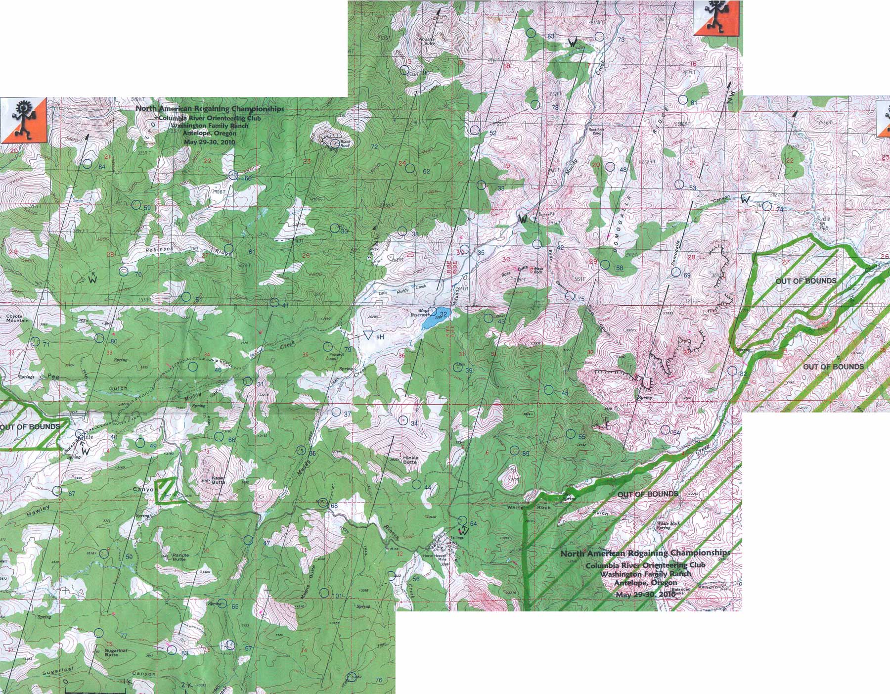
For anyone interested in the planning process, and how we managed to pick the dumbest route from a purely strategic/competitive perspective, but also by far the smartest route from a make-the-night-fun perspective, here's a bit of the thinking. If it seems not so well thought out, well, we were quite happy with it.
First, it seemed like a big loop around the outside made sense, getting all the higher point ones, with the exception of 54 and 82 which were too far out of the way for us. We both agreed on that. If by any chance there was time left over, there were more controls available close in.
Second, it seemed like starting in the south/southwest, and finishing in the southeast/south, gave easy access to this outer loop.
Third, we just connected what seemed like a reasonable number of circles.
Fourth, we measured the beeline distance, not quite 60 km, right about what we thought we could do.
And damn, we were basically done in less than 30 minutes of planning (we had about 2 hours), except for ....
Fifth, take a quick look to see that at least a few of the night ones are interesting (i.e. more difficult). And they certainly were. Cool. We were done. Plenty of time to hang out before the start, and no stress.
A cynic might say that we could hardly have made the day any easier, nor the night much harder, a polite way of saying we had the worst possible route. We'll take that as a compliment. :-)
I'll put up our routes and a few comments, but it's won't be until tomorrow. zzzzzzzzzz.....
Note
slept:2.0
Skipping the various details (Kissy would certainly nail me for a TMI infraction), I'm now starting on the treatment for Lyme disease, Doxycycline, plus another general antibiotic just for good measure.
I suppose I should check with Clint and Phil as to their experience with this.
Note
Get home, ready to get some medicine working, and then to post the rogaine map after dinner, the story already mostly written in my mind, and the phone rings. Nice woman that took care of me at the pharmacy. Seems I left the prescriptions in the shopping cart. So back I have to go, another 20 minutes each way.
Would somebody please just shoot me....