Training Log Archive: PGIn the 30 days ending Jun 30, 2016:
| ||||||||||||||||||||||||||||||||||||||||||||||||||||||||||||||||||||||||||||||||||||||||||||||||||||||||||||||||||||||
| « | » |
| » now | ||||||||||||||||||||||||||||||||||||||||||||||||||||||||||
| We | Th | Fr | Sa | Su | Mo | Tu | We | Th | Fr | Sa | Su | Mo | Tu | We | Th | Fr | Sa | Su | Mo | Tu | We | Th | Fr | Sa | Su | Mo | Tu | We | Th | ||||||||||||||||||||||||||||||||
Tuesday Jun 28, 2016 #
biking - red bike 1:05:00 17.75 mi (3:40 / mi) +425ft 3:35 / mi
ahr:128 max:150 weight:140.5lbs
Monday Jun 27, 2016 #
biking - red bike 9:46 [2] 2.22 mi (4:24 / mi) +38ft 4:20 / mi
Sunday Jun 26, 2016 #
biking - red bike 3:07:01 44.78 mi (4:11 / mi) +3091ft 3:55 / mi
ahr:137 max:157
The 45-mile loop seemed like plenty at this stage of my life and my training, and it turned out to be a good choice. My legs were tired from the get-go, whether still feeling the effects of Friday's long hike or probably just one of those days. Knew it within the first couple of miles.
So I just keep shifting into lower gears (and going slower). And not worrying about it. :-) Rode almost entirely by myself. And that's fine too.
The topography is quite different from what we have around home. No flat places of any substance, lots and lots of hills, but much smaller ones than here. So the climbs kept coming, and there could be steep sections, but they were never real long, never just endless up for 4 or 6 or 8 miles. But did I say that they kept coming?
One quick stop to fill my bottle and grab a couple of cookies, otherwise just moseying along. Really enjoyed the countryside, a beautiful mix of homes and farms and woods and small lakes. Nice day too, sunny and getting warm, but never felt hot until after I was done. And though I always felt tired, there were no real problems, the back and butt and arms and hands and neck weren't complaining at all. That's not so bad.
Friday Jun 24, 2016 #
hike 6:57:56 16.07 mi (26:00 / mi) +3214ft 21:52 / mi
ahr:116 max:143 weight:139lbs shoes: pegasus 6
Not a summit that gets high ratings -- a long approach (and equally long exit), stream crossings that can be dangerous in high water (or an alternative to the two worst ones, a non-trivial bushwhacking section), much of the climb/descent on an old and unstable slide, and no marked trail to the top so you have to pay attention. But perhaps because of the fair amount of apprehension about the various difficulties, it was a fine adventure.
That's not to say it was all handled with grace and skill by yours truly, though at some point I was thinking how easily I was coping with things. This was just after the first bushwhack, about a mile through a not so awful White Mountain forest, where I'd come out just about where I'd planned to with the error being on the correct side. I was back on a respectable trail. It had not rained a lot recently, so the mud was much less than it could be. My feet were still dry, my mood was fine. I can do this stuff.
And then I came to my first stream crossing, looked doable without getting wet, except on one jump to a wet rock I slipped and the next moment both feet were underwater, both hands (and gloves), in fact a good bit of me even though the water was only a foot deep. Yup, you sure can do this.
Got across the next two crossing OK, then headed up the slide. Not a lot of fun, but eventually it and the rest of the climb got done. Slipped once and banged an ankle, but not enough to do any harm. Slipped another time and banged a knee, this one hurt more, but it soon disappeared. In each case I was reminded of how vulnerable one is, a long long ways from any help, and if on a bushwhack, maybe a long, long time before anyone comes by. And I really was trying to be careful.
Finally up on top of the ridge, almost no views, looking for the little bump that is the summit. Found it, a guy was sitting there eating, we chatted for a moment (he'd started his hike an hour and a half before mine, so that was good for morale). And then headed back.
Didn't take long before I f'ed up again, somehow got off the "trail", ended up floundering through about 100 yards of dense spruce with lots of blowdowns, not so bad in retrospect but not that much fun while you're doing it. Crawling under one blowdown I got a branch in the eye. Great, thinking back to the times orienteering when I'd done something similar and hadn't been able to drive home. But fortunately this one disappeared after a few minutes of tearing.
Then down the slide, I mean I'm good at steep crappy downhills -- I passed a couple that looked like they were going to be there all afternoon. But this one was nasty. Took a couple of spills, but both the good kind (feet slip on the loose rock and you land on your butt) and not the bad kind (you catch a toe and go down face first), so no harm down.
Eventually down, eventually passed the three crossings on the way back, now just the bushwhack uncertainty to deal with. There were signs of a "herd path" which I followed as well as I could but lost after maybe half a mile. And then just careful on my bearing to a much smaller target and this time just nailed it, perfect. Three and a half miles left of very good trail and it was done. Very happy to be done, also very happy to have done it.
And almost certainly not to be repeated. :-)
(Bird list for anyone who might be interested, all just heard except for the waxwing and the phoebe in the parking lot when I arrived -- hairy woodpecker, wood-pewee, least flycatcher, phoebe, great crested flycatcher, red-eyed vireo, raven, black-capped chickadee, winter wren, swainson's thrush, cedar waxwing, ovenbird, yellowthroat, redstart, yellow warbler, chestnut-sided warbler, blackpoll warbler, black-throated blue warbler, black-throated green warbler, junco. Often hard to hear when along streams, so best during the bushwhack and on the slide. But excellent entertainment the whole time.)
Black Pond, best view of the whole hike, also start of the bushwhack --

Summit cairn showing typical view --

And a little look at the Franconia ridge, specifically the slides on the east slopes of Mt. Lincoln --

Thursday Jun 23, 2016 #
biking - red bike 54:49 11.79 mi (4:39 / mi) +708ft 4:24 / mi
ahr:117 max:163 weight:139.5lbs
And a slight detour to Mike's on the way home to check on the corn. It's growing.
Wednesday Jun 22, 2016 #
biking - red bike 2:04:57 32.81 mi (3:48 / mi) +736ft 3:44 / mi
ahr:127 max:153 weight:139.5lbs
Wind sure changed, modestly out of the south (when I was heading south), then changing over to out of the west, and then when I reached Whately (and still had a ways further north to go) strong and gusty from the NW. Not the best planning, though a couple of miles towards the end were very nice.
run/hike 45:37 3.01 mi (15:10 / mi) +756ft 12:15 / mi
ahr:120 max:140 shoes: pegasus 6
Tuesday Jun 21, 2016 #
biking - red bike 1:45:07 25.98 mi (4:03 / mi) +1549ft 3:50 / mi
ahr:129 max:156 weight:140lbs
So it was a matter of, whenever there was any doubt, just put it in the lower gear.
This looks like an interesting thing to do on Sunday. There is chatter on AP about how the climb is figured and how it sometimes seems off the mark. For this ride, or at least the 62-mile version that I looked at a little more carefully, the link goes to MapMyRide, which gives 65.5 miles and 2,382' climb. Whereas Ride with GPS gives 62.5 and 5,938' climb. That's a fair bit different. A glance at the topo of the route convinces me that the latter number is more in the ballpark.
Monday Jun 20, 2016 #
run/hike 1:08:35 4.28 mi (16:01 / mi) +940ft 13:16 / mi
ahr:107 max:132 weight:140lbs shoes: pegasus 6
Sunday Jun 19, 2016 #
biking - red bike 46:10 12.42 mi (3:43 / mi) +147ft 3:41 / mi
ahr:125 max:141
Saturday Jun 18, 2016 #
biking - red bike 1:50:38 29.46 mi (3:45 / mi) +1575ft 3:34 / mi
ahr:138 max:160 weight:141.5lbs
I ride by myself most of the time, very used to setting my own pace, so riding with someone else always adds a certain stress. My legs seem to still be feeling tired, so there were a few, or more than a few, times when the pace up a hill was definitely out of my comfort zone. Whereas Phil seemed to be on cruise control (other than his complaining butt).
Still, enjoyed it a lot, and more than I would have done on my own.
Friday Jun 17, 2016 #
biking - red bike 1:16:35 20.33 mi (3:46 / mi) +647ft 3:39 / mi
ahr:129 max:151 weight:141lbs
Thursday Jun 16, 2016 #
biking - red bike 29:37 7.83 mi (3:47 / mi) +31ft 3:46 / mi
ahr:116 max:143
Pretty tired from yesterday, but not very much soreness. Not sure how I will manage Owl's Head (18 miles). Do they have sherpas up there?
Wednesday Jun 15, 2016 #
run/hike 3:54:03 9.87 mi (23:43 / mi) +3604ft 17:37 / mi
ahr:126 max:147 weight:141lbs shoes: pegasus 6
Nice outing. Weather was perfect, breeze kept the bugs away, had the trails mostly to myself, and no falls! Kept my eyes on the trail the whole time, and didn't really miss anything because there were no views except for from the very top of The Horn, and with the foliage out I wasn't going to see the birds anyway.
And the body seems to have survived. And to show that I am only 5 years behind the times (or maybe 10?), I texted a selfie of me at the top of Mt. Cabot! And she actually got it!
And then drove over to Marshfield (VT) in the late afternoon, very enjoyable visit with Mike and Vivian, lots of catching up to do.
Monday Jun 13, 2016 #
run/hike 1:00:57 4.24 mi (14:23 / mi) +970ft 11:50 / mi
ahr:115 max:140 weight:140.5lbs shoes: pegasus 6
Sunday Jun 12, 2016 #
run/hike 42:31 2.41 mi (17:38 / mi) +1069ft 12:25 / mi
ahr:123 max:141 weight:141.5lbs shoes: pegasus 6
Short but steady climb. Lower half is a relatively new trail (replacing the access road to the water tower) and is very nice, hardly any rocks. Rest of the way is the normal rocky trail.
I gave some thought to a second lap, but wasn't sure if it would do more good than harm, so passed.
I think the legs re getting a little stronger. One of these days I'll head off to the Whites to see if that is indeed the case. Two more to do up there, Cabot and Owl's Head, and if I am ever going to do them, I best not wait much longer. Cabot will be first, both a good bit easier, plus Owl's Head has zero redeeming value (long hike in, climb/descend a steep slide, no views), so somehow it seems appropriate for it to be last.
Saturday Jun 11, 2016 #
biking - red bike 1:32:20 23.65 mi (3:54 / mi) +1250ft 3:43 / mi
ahr:140 max:159 weight:141.5lbs
hike 58:35 [2] 2.77 mi (21:09 / mi) +482ft 18:10 / mi
Still almost no bugs. Not complaining since I assume the FDFs will be showing up soon.
Friday Jun 10, 2016 #
run/hike 2:45:11 9.38 mi (17:37 / mi) +2623ft 13:55 / mi
ahr:111 max:136 weight:141lbs

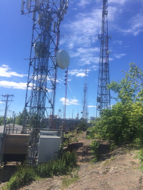
Down at the south end it has become quite an electronic jungle --
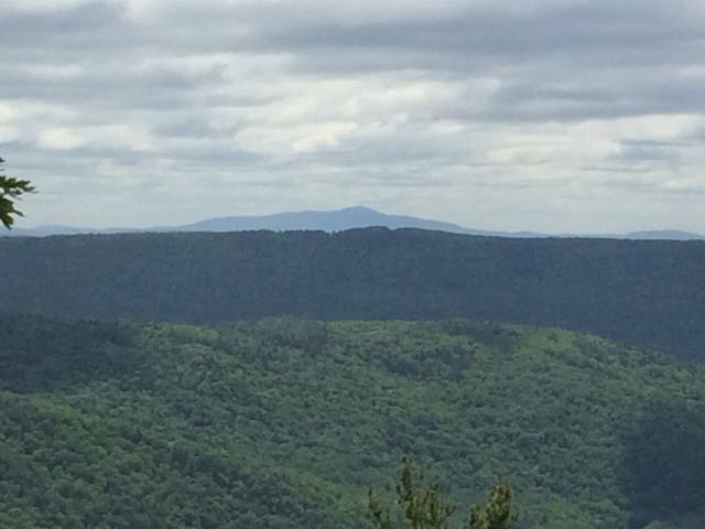
But a good outlook, could see Hartford to the south, Greylock and Mt. Snow to the NW, and Monadnock to the NE.
Decided I didn't need to do the cliffs again. Jogged down the access road (a common training route for hill repeats, though I seem to have not even managed it once), then past the defunct ski area and quarry and eventually back to the M&M and once more over Goat Peak.
Legs were better than expected at the end, had some zip on the last couple of smallish climbs. And jogged (carefully) several of the downhills. But still walking much more than jogging.
A good assortment of birds keeping me entertained, almost all by ear, but one making a very close and very visual visit atop the cliffs was a black vulture. Just curious, or eying a potential meal? Uncommon around here so it was a nice surprise.
Note

Monadnock was in the open, but I'd guess the wind was really ripping on its open summit --
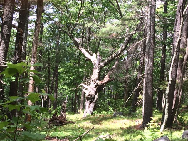
Meanwhile maybe 100 yards from the top of Bald was an old deciduous tree, clearly having grown up with no other trees around. I'd guess 150 years ago Bald Mountain was pretty bald.
biking - red bike 28:39 7.69 mi (3:44 / mi) +63ft 3:42 / mi
ahr:119 max:145
Thursday Jun 9, 2016 #
run/hike 1:05:10 3.58 mi (18:12 / mi) +1327ft 13:28 / mi
ahr:117 max:137 weight:140lbs shoes: pegasus 6
I always meant to check it out, but never did until today. And with today being on the cool side, and very very windy, it seemed quite sensible to head out in the elements for a bit.
Worked my way up, just walking, thinking from time to time how impossible it would be to run it. Of course I was younger once, presumably stronger, but it still would have been a challenge. Today the challenge was trying to hear the birds over the roar of the wind and, at least for the first part, the beautiful tumbling stream the trail was following.
Got within sight of the top, 100 yards at most, when the phone rang. Gail. Hmm, wondered what was up. Answered.
"Happy Anniversary!"
Well, she got me this year. :-)
Neither one of us is too good on the memory front, so it's become a game, when June 9 rolls around, to see who remembers first. There are bragging rights for who remembers first, and also bragging rights for knowing but waiting, as long as you are the first to say, because the longer you wait, the more obvious it is that the other person doesn't have a clue.
So today she waited to about 11 am, and she could have waited all day, because it was clear I didn't have a clue.
Back to the hike, decent views from the top, also continuing strong winds, might try to claim it was good character building, except for that to be true the temperature really would have needed to be about 40 degrees colder. As it was, actually rather pleasant.
And then carefully jogged back down almost all the way, Charlie's advice playing over and over in my mind -- look where you are putting your feet. I did. No falls, not even any stumbles. :-)
===========
I brought along all my bike stuff, thinking I might take a modest ride, the appeal of new terrain offsetting the lack of appeal of the winds. It was only when I passed Brattleboro that I realized I had forgotten the bike....
Wednesday Jun 8, 2016 #
Note
1.jpg)
2.jpg)
biking - red bike 44:53 11.96 mi (3:45 / mi) +300ft 3:40 / mi
ahr:129 max:155 weight:140lbs
run/hike 41:06 2.36 mi (17:26 / mi) +978ft 12:31 / mi
ahr:118 max:132 shoes: pegasus 6
Tuesday Jun 7, 2016 #
biking - red bike 1:48:26 29.29 mi (3:42 / mi) +792ft 3:37 / mi
ahr:131 max:152 weight:140lbs
Nice morning. Supposed to get thunderstorms as the day progresses, hence the relatively early ride.
hike 25:51 [2] 0.94 mi (27:30 / mi) +554ft 17:39 / mi
shoes: pegasus 6
As has been evident for some time, and only becomes more so, I no longer have the zip to get up with any sense of urgency, nor the nerve to come down with a similar sense. 14:10 up, 11:41 down. I think I used to get up in the vicinity of 8 minutes, and once at the end of the Seven Sisters race I got down in not much more than 4. That part of life is long gone. But at least for a little while longer I can still make it.
Legs tired from the bike ride earlier, but that was sort of the point.
Monday Jun 6, 2016 #
biking - red bike 1:12:49 20.28 mi (3:35 / mi) +543ft 3:30 / mi
ahr:139 max:164 weight:140.5lbs
And a nice walk this morning with the Monday ladies. Something between 3 and 4 hours, and the back not really complaining. :-)
Sunday Jun 5, 2016 #
hard core 2:00 [3] 0.1 mi (20:00 / mi)
For control pick-up, managed to recruit enough others (Ross, Alex, Jon Marsden, Steve Tarry) to get them all so I could leave early and go back to Litchfield and see how Gail was doing -- she'd been sick all night, and all morning as it turned out. Eventually had to deal with the drive home, had to stop several times but by then there wasn't really much more to come up. Miserable doesn't start to describe how she was feeling. :-(
Note
Ed keeps coming up with all these new ways to make things even cooler. What's amazing is that they all seem to work. And he seemed to have a smile on his face the whole time.
Becky got everything right in the forest. The Pond Mountain courses were excellent. The sprint was as good as could be done with a campus that offered rather limited possibilities, severe restrictions from the college (of course, we were lucky to be able to use it at all), and summer construction projects that were just getting started and quite literally were changing the map every day. She also managed to recruit her very cool mum and dad for placing and checking controls, putting out water, and doing whatever else needed to be done.
I hope folks that were there appreciated what these two did.
Saturday Jun 4, 2016 #
Note
orienteering 1:44:19 3.9 mi (26:45 / mi) +630ft 23:12 / mi
ahr:115 max:136
Told Gail to meet me at the south end where the AT crosses the road, I'd be about 1:45. Got there in 1:50, not so good, forgot I had to clean up a couple of water stops. Fortunately Becky had left a trash bag at each one, so no need for someone to go back.
Woods are still gorgeous.
Friday Jun 3, 2016 #
biking - red bike 57:53 15.26 mi (3:48 / mi) +643ft 3:39 / mi
ahr:136 max:153 weight:141lbs
And, while I know Phil and Alex will consider this impossible, and thus an outright lie, I have once again cleaned and lubed my chain after riding. Things, even the moving parts, still look pretty shiny. :-)
Thursday Jun 2, 2016 #
biking - red bike 1:17:15 21.55 mi (3:35 / mi) +198ft 3:33 / mi
ahr:131 max:148 weight:141lbs
hike 1:05:34 3.95 mi (16:36 / mi) +594ft 14:32 / mi
ahr:111 max:137 shoes: pegasus 6
Mid-afternoon and now in June, the forest is getting quieter and denser. Count was just 13, of which only 1 was actually seen.
Wednesday Jun 1, 2016 #
biking - red bike 1:39:07 21.79 mi (4:33 / mi) +2165ft 4:09 / mi
ahr:138 max:160 weight:141lbs
I'm certainly not used to finishing with a 1,250' climb, and while I never had to get off the bike, the pace was mighty slow. Haven't been doing many hills, and it showed.
Legs felt tired to start, more so at the end. But the back is holding up well. :-)