Training Log Archive: PGIn the 7 days ending Dec 6, 2010:
| ||||||||||||||||||||||||||||||||||||||||||||||||||||||||||||||||||
| « | » |
| » now | ||||||||||
| Tu | We | Th | Fr | Sa | Su | Mo | |||||||
Monday Dec 6, 2010 #
Note
Here's a map of all the controls for the orienteering at Quabbin yesterday afternoon (and a larger version).
.jpg)
Every course went up the east side and had #13, then went to some of 14-17. The shorter versions south towards the last two common controls (34 and 35). Meanwhile, the faster/stronger folks did 18, and then there were various longer or shorter permutations on the west side of the road, all of which ended with 26 before heading to the negative terrain at 29-33.
It was quite good fun setting the courses once I decided on the concept and the general flow. Just head out, keep marking points with the main requirement being that they be distinct and visible since we were only using streamers. The hassle was that the vegetation had thickened up substantially in some places, especially east of the N/S road.
And then drawing the individual courses was both tedious and amusing, the latter because I could think for each person where I did or did not want to send them -- like for Boris, better not send him up the hill to 18, he's too weak, but Sam and Ali sure can go up there. As JJ said, everyone was running against their reputation.
Note
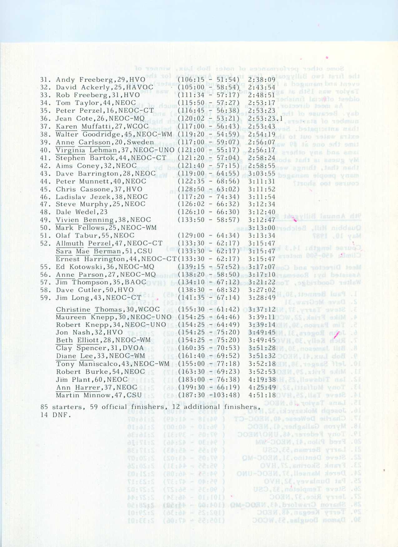
For historical reference, here's the map for the Billygoat at Quabbin in 1987. Course was 14.3 km, no skips allowed. And here is the race report and results -- page 1, page 2, page 3, page 4.
.jpg)
Note
And here's the route for yesterday's sprint at UMass. Interesting that I carried a compass, never used it, and just now noticed there are no north lines on the map. Folks seemed to have trouble at 9 (going off the map) and 11 (ending up on the south side of the wall). My only problem was a few meters off at 8.
Very brisk Sunday morning. Seemed like there were more orienteers out and about than students.
Very brisk Sunday morning. Seemed like there were more orienteers out and about than students.
Note
And here's the route for yesterday's sprint at UMass. Interesting that I carried a compass, never used it, and just now noticed there are no north lines on the map. Folks seemed to have trouble at 9 (going off the map) and 11 (ending up on the south side of the wall). My only problem was a few meters off at 8.
Very brisk Sunday morning. Seemed like there were more orienteers out and about than students.
.jpg)
Very brisk Sunday morning. Seemed like there were more orienteers out and about than students.
Note
And here is my route hanging streamers at Quabbin last Friday. QR lined up very nicely this time (sometimes it takes lots of adjusting).
A careful look will show a couple of diversions, both to hang streamers that were not used. They were intended for a course for Alex's mom Kitty, but then she was heading home to Rochester and didn't run. Which simplified things greatly, as I was having a hard time get a course for her as in a couple of places the trails had major obstacles. Not sure what i would have ended up doing, but fortunately didn't have to deal with it.
The other concern was dogs. One was Kitty's, but it was also on the way back to Rochester. The other was Presto. Lori was under instructions to deny any connection to O' if approached by a cop, but thankfully they were nowhere to be seen.
QR.jpg)
A careful look will show a couple of diversions, both to hang streamers that were not used. They were intended for a course for Alex's mom Kitty, but then she was heading home to Rochester and didn't run. Which simplified things greatly, as I was having a hard time get a course for her as in a couple of places the trails had major obstacles. Not sure what i would have ended up doing, but fortunately didn't have to deal with it.
The other concern was dogs. One was Kitty's, but it was also on the way back to Rochester. The other was Presto. Lori was under instructions to deny any connection to O' if approached by a cop, but thankfully they were nowhere to be seen.
Note
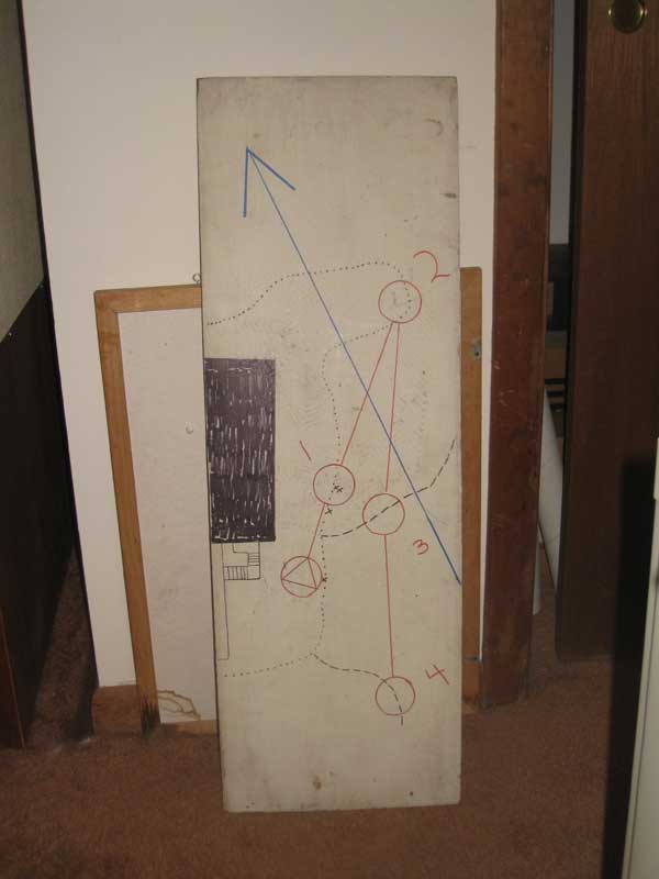
One more map to add from the weekend -- the ski-O' map (and the map holder, very sturdy and quite inseparable from the map). The map was perfect, hand-drawn too, no point in OCAD as we didn't have a printer that would handle 1 x 12" boards.
Sunday Dec 5, 2010 #
orienteering 23:37 [4] 3.1 mi (7:37 / mi)
shoes: x-talon 212 #2
Alex's sprint at UMass. Really fun, although like pretty much any orienteering I've ever done, there was a sizable element of just plain hard work. My 305 was DOA, so no heart rate data, but it was pumping away quite vigorously.
Surprised that the fast guys weren't faster (best time was 20 minutes), but I think they all had a problem or two.
I'll put the map up in a while, but I'm moving in super slow motion this evening, just no energy and can't get anything down. A bit of stress getting things set for the weekend and also dealing with Litchfield matters, and I think the gas tank is a bit low.
Cold (about 30F), but Alex had her office open for refuge and toilets, for which she gets many gold stars.
Note
Over to Quabbin for the final event of the weekend, mass start relay training (or just training with other people around who are maybe going to the same control, or maybe not). Different courses for all 19 starters. Seemed to work out well, mass start, didn't get the mass finish I'd hoped for, but everyone was in within a 20-minute window, and on a cold day with no shelter that is a very good thing.
First orienteering at Quabbin in 15-20 years (other than a few solo training runs). Way back when it was the site of the 1979 Team Trials, a New England Champs, a couple of Billygoats, and a number of local meets. But they really didn't like us. If we'd had any sense, we'd have made a nice donation to their "Friends" organization and I'm sure that would have greased the necessary wheels.
The contours are still good but the vegetation has changed a lot -- still a lot of really nice forest but also now more thick areas. And in the growing season there are quite a lot of ferns. But for what we were doing today it seemed to work real well.
Again, map (with all the controls) coming....
Saturday Dec 4, 2010 #
Event: CSU Orienteering Superstars
Note
Superstars weekend. Just managed to stay one step ahead as far as having things ready when they were supposed to be ready. Weekend was great, but my superstars performance left a lot to be desired, wrapped up by a dismal showing at the bowling lanes, though at least I managed to stick the axe in the axe throw, in not so many tries.
But the event was really fun. Laughed and laughed. Of the seven regular events, 6 were repeats from last time 20 years ago. The new one, the ski-O was fabulous. And then we had the bonus events -- crutches (around the ski-o course on crutches), the axe throw, and the wife-carrying race (or husband or partner) -- plus a team competition, plus some awesome pole dancing. As I said, I laughed and laughed.
But the event was really fun. Laughed and laughed. Of the seven regular events, 6 were repeats from last time 20 years ago. The new one, the ski-O was fabulous. And then we had the bonus events -- crutches (around the ski-o course on crutches), the axe throw, and the wife-carrying race (or husband or partner) -- plus a team competition, plus some awesome pole dancing. As I said, I laughed and laughed.
Friday Dec 3, 2010 #
1 PM
orienteering 2:13:43 6.08 mi (22:00 / mi) +935ft 19:12 / mi
ahr:119 max:150 shoes: saloman
Hanging streamers at Quabbin, 38 of them. Easy in places, the contours are still excellent, harder in others where the vegetation has changed. Think I did it so that if people end up in the dark green (mapped as white!) it's their own damn fault. Still a lot of really nice forest. I'm sure that more rock would be mapped now, but I'm not sure whether that is progress.
Map is 1:15, features on the map are rather small, but for a 1:15 map it is pretty easy to read. Still might want to bring your magnifier if your eyesight is shaky.
Sorry, no map of my track just yet. :-)
Now have to draw the courses on the maps. Everyone will get a different course, so that in addition to having a mass start, we will also have a mass finish, as long as everyone orienteers the way they usually do. Makes it a lot easier for the organizers, just need to get the time for one person.
Thursday Dec 2, 2010 #
10 AM
mountain biking 2:05 [3] 0.19 mi (10:57 / mi)
weight:142lbs
The course for Superstars, first lap 1:05, second 1:00. Joe ought to be able to do laps in 45, Alex in 40.