Training Log Archive: PGIn the 7 days ending Jun 5, 2011:
| ||||||||||||||||||||||||||||||||||||||||||||||||||||||||||||||||||
| « | » |
| » now | ||||||||||
| Mo | Tu | We | Th | Fr | Sa | Su | |||||||
Sunday Jun 5, 2011 #
Note
And then not having had enough exercise (to and from the start/finish from the car park was only 30 minutes today, I hustled off in mid-afternoon for a round at Bantry Bay Golf Club.
Actually it was for a little more map reading practice. There was no course map on the scorecard, but there was an aerial photo on the club's brochure, and it sure came in handy as I was as wild with my driver as I have been in a long time. Hitting it way off line, unbelievably finding the ball each time, and then consulting the aerial for a possible new route to the green.
Very pretty course, also pretty difficult, played it at about 6500-6600 yards, par 71, plus the wind was probably 20-30 miles an hour, I'd guess just a mild breeze for the locals, but several times I had to chase down my hat, and my bag got blown over a few times. Gail says I was getting a true Irish experience, except that it wasn't also raining hard.
Took me 3:20 to get around, I was moving as fast as I could, up and down a bunch of hills, but all the extra yardage finding my wayward shots, and then figuring out what to do next, added probably 30 minutes to the round. But enjoyed it a lot, scored a lot better (93, playing by the rules) than I deserved, because as JJ would say, I was sucks.
The first tee, no warm-up, dropped it right on the green, three putts later an easy 4....

And the tenth tee, 420 yards, dead into the wind, seldom have I seen a narrower target. I played it with imagination -- a drive way right, up near the 9th green, but in play, a second shot over a bunch of trees, again quite a ways right but just about hole high, and again in play, third shot a lob wedge over the greenside tree, 2 putts for an easy bogey. Deserved to get about a 10..... :-)

Actually it was for a little more map reading practice. There was no course map on the scorecard, but there was an aerial photo on the club's brochure, and it sure came in handy as I was as wild with my driver as I have been in a long time. Hitting it way off line, unbelievably finding the ball each time, and then consulting the aerial for a possible new route to the green.
Very pretty course, also pretty difficult, played it at about 6500-6600 yards, par 71, plus the wind was probably 20-30 miles an hour, I'd guess just a mild breeze for the locals, but several times I had to chase down my hat, and my bag got blown over a few times. Gail says I was getting a true Irish experience, except that it wasn't also raining hard.
Took me 3:20 to get around, I was moving as fast as I could, up and down a bunch of hills, but all the extra yardage finding my wayward shots, and then figuring out what to do next, added probably 30 minutes to the round. But enjoyed it a lot, scored a lot better (93, playing by the rules) than I deserved, because as JJ would say, I was sucks.
The first tee, no warm-up, dropped it right on the green, three putts later an easy 4....
And the tenth tee, 420 yards, dead into the wind, seldom have I seen a narrower target. I played it with imagination -- a drive way right, up near the 9th green, but in play, a second shot over a bunch of trees, again quite a ways right but just about hole high, and again in play, third shot a lob wedge over the greenside tree, 2 putts for an easy bogey. Deserved to get about a 10..... :-)
12 PM
orienteering 43:11 2.86 mi (15:06 / mi) +610ft 12:34 / mi
ahr:149 max:159 shoes: pegasus
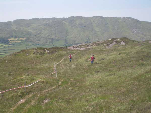
Shamrock day 2. Whatever hills we missed yesterday we certainly had today. Felt like I was going up most of the time, except at the end when it was down very rapidly.
Not as good a run as yesterday. Missed #1 to the left (not sure how it happened), went too far on #2 and had to come back, and very shaky dropping down to 9, took lots of extra time to finally decide I was too high. Overall maybe a couple of minutes. But very fast going down to 10 and 11, survived without trashing my ankles.
Overall, another day of really fun orienteering. I had a harder time get in synch with the map. The rock seemed not as well mapped as yesterday -- yesterday it all made sense, today I keep not being sure. A different mapper, but probably the difference was just how my brain was (or wasn't) working.
Would be nice to have some competition in my class. I thought about signing up for 55 or 60, but I'm quite happy where I am. I have a 20 minute lead in my class for the chase tomorrow but only 1 minute for the course, ahead of a M-16 Swede. I expect I'll get run down.
Lots more pleasant interactions with the Irish. :-)
The footing was similar to yesterday, though probably a little less nice stuff and a little more heavy stuff....

My course. And my route.
Results.
Not as good a run as yesterday. Missed #1 to the left (not sure how it happened), went too far on #2 and had to come back, and very shaky dropping down to 9, took lots of extra time to finally decide I was too high. Overall maybe a couple of minutes. But very fast going down to 10 and 11, survived without trashing my ankles.
Overall, another day of really fun orienteering. I had a harder time get in synch with the map. The rock seemed not as well mapped as yesterday -- yesterday it all made sense, today I keep not being sure. A different mapper, but probably the difference was just how my brain was (or wasn't) working.
Would be nice to have some competition in my class. I thought about signing up for 55 or 60, but I'm quite happy where I am. I have a 20 minute lead in my class for the chase tomorrow but only 1 minute for the course, ahead of a M-16 Swede. I expect I'll get run down.
Lots more pleasant interactions with the Irish. :-)
The footing was similar to yesterday, though probably a little less nice stuff and a little more heavy stuff....
My course. And my route.
.jpg)
QR.jpg)
Results.
Saturday Jun 4, 2011 #
Event: Shamrock O-Ringen 2011
QR.jpg)
Note
A few photos from today. First, looking from the car park up to the terrain, the start was in the gap just to the right of the one cloud. Seemed like a very long ways away....

About an average size crowd at the finish....

And a couple of kids coming in....
My control #10, easy to see from this direction but we were coming from above....

The last little knoll on the way to the last control....

And the last control itself....

Meanwhile, all the action was back in the car park.

About an average size crowd at the finish....
And a couple of kids coming in....
My control #10, easy to see from this direction but we were coming from above....
The last little knoll on the way to the last control....
And the last control itself....
Meanwhile, all the action was back in the car park.
2 PM
orienteering 30:54 2.33 mi (13:16 / mi) +128ft 12:36 / mi
ahr:148 max:161 shoes: pegasus
Shamrock O'Ringen, day 1. Fabulous. Wide open spaces, not a tree to be seen, very interesting. Would have been even more interesting, and a lot harder, with some fog or mist or whatever they call it here. But it was still just fine.
I thought the running was going to be worse than it was, as the ground was quite uneven, but the only really bad places were the marshes, just grass but hummocky, had to try to run between the humps, fell down a few times but at least it was always a soft landing. Best running was on the rock, even when it was tilted, nice and firm even if a bit tough on the ankles.
And the orienteering was just a lot of fun. No mistakes to speak of, though close -- I wasn't too far from #2 when I decided I really should go to #1 first, and from 6 to 7 I was quite insecure and cautious, but basically all the flags were where I expected them. And my legs were OK, supposed to be 80 meters climb, but didn't really feel like any. The hardest running was across the marshes.
My course. Straight-line distance was 3.6 km. And my route.
.jpg)
QR.jpg)
Friday Jun 3, 2011 #
Note
So, Ireland is interesting. Who knew it was part of the Caribbean -- islands, beaches, lush vegetation?


Agriculture is thriving....

There is some old stuff too --
Ross's castle, in Killarney, mostly restored....

An old abbey, in need of restoration....

An old graveyard (perfect spot for Trail-O'?)....

Some old orienteers (Mr. and Mrs. Bubo)....

And of course there is orienteering. Here was meet headquarters. Registration was at the trunk (the boot?), downloading at the passenger side....

And quite a civilized place, here's the route to the first control....

Tomorrow I think the terrain will be quite different, maybe more like this....

Agriculture is thriving....
There is some old stuff too --
Ross's castle, in Killarney, mostly restored....
An old abbey, in need of restoration....
An old graveyard (perfect spot for Trail-O'?)....
Some old orienteers (Mr. and Mrs. Bubo)....
And of course there is orienteering. Here was meet headquarters. Registration was at the trunk (the boot?), downloading at the passenger side....
And quite a civilized place, here's the route to the first control....
Tomorrow I think the terrain will be quite different, maybe more like this....
6 PM
orienteering 24:36 2.33 mi (10:33 / mi) +128ft 10:02 / mi
ahr:135 max:159 shoes: x-talon 212 #2
Most important stuff first -- another 21 controls, so the total is now 765/1000. Although perhaps I should only count spiked controls, in which case today would have only added 17....
Sprint course in Kenmare (the "long" course, nominally 3.4 km) on a map called "Rinn na gCros" -- I have no idea what this means, or why the C but not the g is upper case. A strange course, though given the terrain it was as good as could be done. And regardless of the merits of the course, I certainly enjoyed it.
Here's the course.
.jpg)
Thursday Jun 2, 2011 #
2 PM
road running 38:08 4.34 mi (8:47 / mi) +39ft 8:43 / mi
ahr:127 max:144
Not very interesting except for finding a castle, which is worth investigating. And better than taking a nap.
Wednesday Jun 1, 2011 #
Note
weight:136lbs
Control count now -- 744/1000. It's going to be close. Actually, it's only going to be close if I do some extra training sessions in the next two months.
Managed to get plane tickets, car, accommodation, and entries all set for France in August. Looking forward to it. Of course that will just count for the next 1000 (or 2000 for Ali) control challenge as this one ends August 9 (I think).
Managed to get plane tickets, car, accommodation, and entries all set for France in August. Looking forward to it. Of course that will just count for the next 1000 (or 2000 for Ali) control challenge as this one ends August 9 (I think).
Tuesday May 31, 2011 #
Note
A few photos from the weekend --
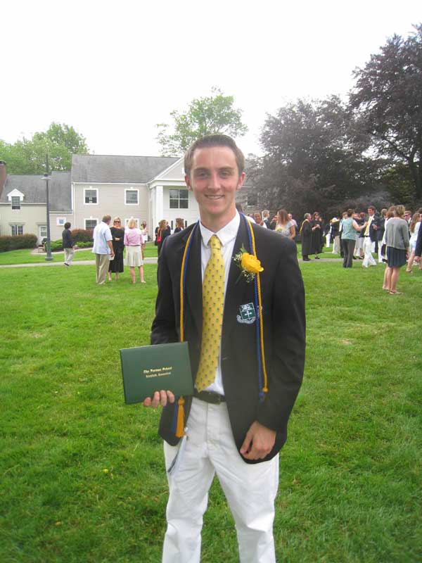
Charlie's son Zach at graduation:
Saturday afternoon we stopped at the Pepsico sculpture gardens, beautiful place.
A large Calder in the distance....

And a much smaller frog, can't remember by whom....
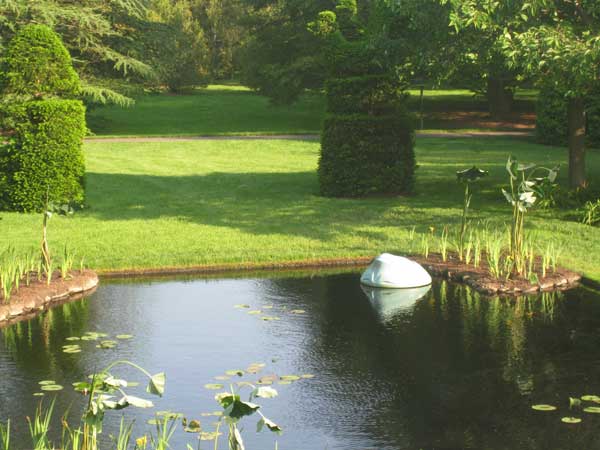
And a delightful Oldenburg....

Charlie's son Zach at graduation:
Saturday afternoon we stopped at the Pepsico sculpture gardens, beautiful place.
A large Calder in the distance....
And a much smaller frog, can't remember by whom....
And a delightful Oldenburg....
Monday May 30, 2011 #
10 AM
orienteering 42:41 2.47 mi (17:17 / mi) +341ft 15:17 / mi
ahr:149 max:163 shoes: pegasus
Middle course at Blue Mountain (red, M-45, same as women's team trials).
Not so bad. Slower than ever as far as just moving through the terrain (and also stopping to read the map), but no mistakes of more than 10 seconds. And that is worth something. So a few scalps taken. :-)
My route. Can't see much that I would have done differently except maybe take the trail around the marsh on the way to 3. And also maybe not fall about 10 yards after the start triangle, a bit of rocky ground, something happened and the next thing I knew I was crashing rather painfully. Fortunately nothing serious.
Another really nice course. Blue Mountain is a great place. I first ran there in 1980. Over the years since then I've actually been there not very often, the most recent being a Billygoat (2002?) and an A meet in 1998. Would be nice to go back more often.
Actually my first time at Blue Mountain was probably in 1979. Ed Hicks had gotten the base map and signed me up to map it. I went down there to start work, spent a few hours, and decided it was more than I wanted to handle, and backed out of the job.
Here's the map from one of the days of the first A meet there in 1980. No OCAD, no GPS, no control printing software, no watches that took splits. Still had the same controls to look for. The map was done by Eric Weyman and Pat Dunlavey, I think it was their first joint project, first of many fine maps.
My one recollection of this weekend was that, having run a 50-miler the weekend before, on pavement (first and only time for that, the pavement part), my knees were quite sore. :-)
.jpg)
Not so bad. Slower than ever as far as just moving through the terrain (and also stopping to read the map), but no mistakes of more than 10 seconds. And that is worth something. So a few scalps taken. :-)
My route. Can't see much that I would have done differently except maybe take the trail around the marsh on the way to 3. And also maybe not fall about 10 yards after the start triangle, a bit of rocky ground, something happened and the next thing I knew I was crashing rather painfully. Fortunately nothing serious.
QR.jpg)
Another really nice course. Blue Mountain is a great place. I first ran there in 1980. Over the years since then I've actually been there not very often, the most recent being a Billygoat (2002?) and an A meet in 1998. Would be nice to go back more often.
Actually my first time at Blue Mountain was probably in 1979. Ed Hicks had gotten the base map and signed me up to map it. I went down there to start work, spent a few hours, and decided it was more than I wanted to handle, and backed out of the job.
Here's the map from one of the days of the first A meet there in 1980. No OCAD, no GPS, no control printing software, no watches that took splits. Still had the same controls to look for. The map was done by Eric Weyman and Pat Dunlavey, I think it was their first joint project, first of many fine maps.
.jpg)
My one recollection of this weekend was that, having run a 50-miler the weekend before, on pavement (first and only time for that, the pavement part), my knees were quite sore. :-)