Training Log Archive: BashIn the 7 days ending Jul 19, 2015:
| |||||||||||||||||||||||||||||||||||||||||||||||||||||||||||||||||||||||||||||||
| « | » |
| » now | ||||||||||
| Mo | Tu | We | Th | Fr | Sa | Su | |||||||
Sunday Jul 19, 2015 #
Trekking (Trail) 45:00 [2] 3.0 km (15:00 / km) +225m 10:55 / km
slept:4.25 shoes: Salomon XA Pros light blue 201
Race report is coming...
After last night's adventure, I wanted to return to the Männlichen Bergrestaurant as a thank you for their kindness to the runners. 'Bent and I had lunch there and hiked to the peak. It's a beautiful place when it's not stormy!

Wengen, the village in the lower right of the photo, is the place we came up from to get here in the race.

When we got down to lower Grindelwald, we walked back up to our hotel. I had to go down stairs sideways but otherwise, I felt better than expected.
Saturday Jul 18, 2015 #
Note
slept:2.0
Note
Eiger Ultra Trail, E101
Specs: 101 km, 6700 m vertical, 26 hr time limit
Elevation Profile

Storm-shortened Course Specs: 88 km (I went almost 90 km due to confusion over the revised course), 5280 m vertical
Official time including storm stop: 22:37:07
Actual racing time: 20:55:00
The Eiger Ultra Trail is a 101 km mountainous loop that starts and finishes in Grindelwald in Switzerland's Bernese Oberland. This challenging, 3-year-old trail running race is part of the Ultra-Trail World Tour so it attracts elite runners but there is no lottery or qualification process for us ordinary mortals.
Ueli Steck, who set the speed record for climbing the Eiger north face, is the race ambassador. Normally he is at the race but this year he spoke to us at the race briefing by video. He’s in the midst of a project to summit all 82 peaks over 4,000 m in the Alps in 80 days, using only human power – foot, bike and paraglider – to travel between them. He says he’s going to do the Eiger 101K race next year; he came 9th in the 51K in 2013.
Our race started at 4:30 a.m. so the wonderful Hotel Gletschergarten put out a full breakfast buffet at 3 a.m., apologizing for the day-old croissants since the local bakery could not provide fresh baked goods before 6 a.m. The hotel owner would have been horrified to know that my pre-race breakfast sometimes includes day-old coffee and a stale Timmy’s muffin.

I walked through the dark village, falling quietly into step with others headed to the start area where 570 runners were gathering. Given the early hour, the fanfare was limited but dozens of people stood in hotel windows and along the street to cheer us on.

We ran back through town and past our hotel where 'Bent was cheering and taking video.

Then we turned onto trails and began the 1,000+ m climb to Grosse Scheidegg.

Even before sunrise, the humidity was high and I felt too warm. We had to stop for almost five minutes when a narrow bridge and trail forced the runners to funnel down to single file. It was against the rules to overtake anyone there. After that, there were short bursts of running between long stretches of uphill hiking with poles.

The sun emerged from behind the mountains as I arrived at Grosse Scheidegg.


This was one of the two biggest climbs in the race; I felt good and was 35 minutes ahead of the first cut-off. Yay.


The only small negative was that the distance to Grosse Scheidegg was 1 km longer than advertised, according to my trusty Ambit, so organizers hadn’t updated the pace charts or overall race distance since moving the start/finish to the opposite end of Grindelwald. This should be OK but it meant that distances would be a little off for the rest of the day.
We ran on rolling trails to First (pronounced “Fearsht”), the cable car station we'd visited two days ago. The view of the Alps in the morning light was spectacular. I took a very Swiss photo – the north face of the Eiger and a cow.

At First, the 51K racers continued along the plateau while the lucky 101K racers were sent on a cruel 500 m descent to Berghaus Bort before climbing back to First on different trails.


I assumed (correctly) that 'Bent, who started 75 minutes after me in the 51K, would pass First while I was doing my loop down and up. Shortly before I headed downhill, the top two 51K runners passed me, decked out in full Salomon gear. It was wonderful to see how easily they moved on rocky trails – like dancers.
Naturally, we didn't take the direct route from First to the Faulhorn, the high point of the course at 2,680 m. That would have been too simple! We took a detour to Oberläger Bussalp, which took us onto more rugged, ankle-turning trails but also rewarded us with beautiful scenery.


It’s hard to see but there are tiny runners going down the green ridge.

Richard texted to say he was on the Faulhorn feeling good at the halfway point of his race. Fantastic! He went on to place 11th of 94 runners in his category in spite of some stomach troubles at the very end. This photo was taken when he passed the Bachalpsee. No, it wasn’t posed. The professional photographer had his set-up totally dialed, and Richard looked ridiculously perky after 15 km.

Shortly after we started our 650 m climb to the Faulhorn, I re-applied sunscreen, which brought on the rain.


As we got higher, the wind came up. I must have been the only Canadian because almost everyone else put on raincoats and other layers. I was just grateful to feel cool for a change.

Only a little farther to get to the top of the Faulhorn. Some day when I’m rich, it would be cool to stay in that hotel.

A few days earlier, we caught our first view of the Faulhorn from the north, from Schynigge Platte; it’s the small peak in the notch. Seeing it made Richard turn white!

We also saw it from the south on Thursday when we took the cable car up to First. It’s the small-looking peak in the centre with snow on its slopes (only small-looking because it's in the distance).

Close up, it looks like it belongs in a children’s story book.

A lot of runners took breaks on the Faulhorn. What a beautiful place! I was an hour ahead of the cut-off and feeling healthy and happy with a third of the race completed. Unfortunately, the Eiger Ultra cut-offs are like uncoordinated traffic lights with some of them harder than others so I didn’t expect to keep my one-hour cushion.


I didn't stay long but if I could do it over, I would have waited in line for the washroom since the trail was very open for the next few hours. There's nothing more relaxing than pounding along a trail above treeline when you're well hydrated. :)
We did some spectacular open ridge running and also some technical rocky sections.


On paper, it had looked like a nice descent for the better part of 20 km but it was often slow going on lumpy trail surfaces.


It was hot so I tried the "sponge inside the hat" trick we'd learned from Lu, a local runner we’d met in an outdoor store. Whenever I passed an ice cold, glacier-fed creek, I'd wet the sponge again. It helped since I could squish it when I wanted more water on my head.
Other than that, I felt surprisingly good, possibly because of the variety in what I needed to do - some running, some hiking, uphill, downhill, smooth surfaces and lumpy surfaces. I got to the end after 22 hours with no blisters, chafing or foot pain. My quads and hips were starting to feel the downhills but it wasn't a big deal.
This is the view from Schynigge Platte looking back at the mountains we travelled through in the first half of the race course; this was taken when we visited a few days earlier.

At the Schynigge Platte aid station, volunteers directed me around the building to an outhouse that was so “well-used” that I initially backed out of it, thinking in my foggy state, “Oops, that’s the outhouse the cows use.” It took me a moment to realize that made no sense so I was just going to have to be very brave!
The course profile showed a steep descent into the valley but the trail wound through the forest and along the edge of a high, precarious cliff with chain handrail on the inside. It wasn't easy to make up time in this section. There was a surprise steep climb as we skirted a re-entrant in the cliffs. It was super hot so I tried to keep the sponge wet under my hat.
When the trail opened up and became less death-defying, I ignored my quads and rushed down the hill to Burglauenen in the valley below Grindelwald, about 1,700 m below the Faulhorn. I was getting worried about cut-offs farther along the course.
We got our drop bags here and I ignored half the things on my "to do" list to save time. I noticed some runners who had given up and were waiting for the train back to Grindelwald.

The next 700 m climb to a hill overlooking Wengen was a killer - the hottest part of the day with runners so spread out that I was mostly alone. I needed to make time but I moved like molasses in the heat. There were some beautiful views through the trees.

There were a number of cliffy places on the race course where organizers had put warning signs. If there were cables against the cliff, we were required to hang on. I was impressed to meet a medical volunteer who confirmed that I was feeling OK in this precarious section after 60+ km on a hot afternoon.

At last I saw Wengen 300 m below. Note the rain clouds in the distance. They’ll come up again in this story.

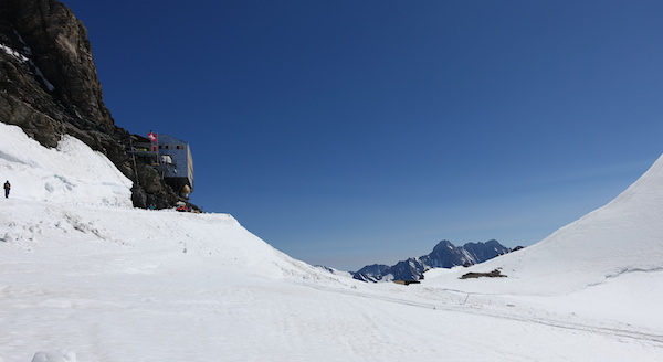
I got to Wengen with half an hour to spare and headed out quickly to climb Männlichen, a peak reached by a steep, mostly exposed 900 m slope. This photo doesn’t do it justice.

This photo I took the next day shows it better. I started climbing up to this place from those tiny houses down there!
For more perspective, Männlichen is the green mountain in the middle of this photo I took before the race. Burglauenen is in the valley on the left. Wengen is out of sight, 300 m below the right shoulder of the mountain. From there, we climbed almost to the peak.

As I climbed, I watched the sky getting darker at the south end of the Lauterbrunnen valley. We'd seen similar clouds earlier in the day and nothing had come of them. For awhile, it didn't look like this would turn into anything or move in my direction. Then the dark sky starting moving toward me. [Insert bad word here.] I was closer to the top than the bottom so I pushed in hopes of reaching the hotel up there. I met some race staff with radios who pointed up and told me to "Hut! Hut! Hut!", which translated pretty well. Runners lower on the mountain were sent back to Wengen.
The thunderstorm hit when I was about 250 m from the top but had completed most of the trail distance. There were at least four lightning flashes that were too close for comfort including one where I saw lightning curling in a spiral at my elevation. I was so terrified that I passed five runners in the last kilometre; who knew I had it in me?! It was raining too but that didn't matter.
I didn't take any photos in the storm but the next day, I took this photo of the last part of the climb. The trail went between huge metal avalanche barriers so it wasn’t a safe place to be with lightning around.

At the top, volunteers were hurriedly tearing down the last of the aid station. They rushed me indoors through the kitchen of the Männlichen Bergrestaurant. What a massive relief! I just sat in a chair and took some deep breaths. I'd made it 36 minutes before the cut-off, not that it mattered much anymore.
This is what the Männlichen Berghaus looked like when I went up the next day. I didn't take any photos of it during the race.
While the storm raged, we were held inside for about 2 hours. I arrived at 9:24 but they had started holding runners at 9 p.m. so most of them got inside before the lightning. Other runners were held at other places around the course. The race has a dedicated meteorologist at HQ to help them with these decisions. Given the tough circumstances, I think they did a great job.

The restaurant staff brought out piles of wool blankets, took orders for hot drinks and refused to accept payment. Really nice. Richard and I went up there the next day and bought an expensive lunch because they deserved it.
I changed into my tights and warm mandatory gear rather than hanging out in wet clothes. If this isn’t the kind of situation where we should use all that stuff, I don’t know what is!

A few runners dropped out and were sent down by cable car. The rest of us were restarted on a shortened course at 11:15 p.m. since the heavy rain had made parts of the trail, including the section under the Eiger north face, very dangerous.
We crossed the timing mat coming in and going out since they planned to subtract the stoppage time. The next day, they changed their minds and called our stop "neutralized" time that would be included in our race time. This meant that all runners stopped at a particular aid station had their arrival time differences erased when the race restarted but they didn’t know it until they saw the results. Weird decision.
We ran directly to Kleine Scheidegg in the last of the rain, rather than going via the Lauberhorn as planned. The volunteers there told us to run 12 km downhill to Grindelwald, following the railway tracks. No problem except that my quads hadn’t been planning on a 1,000 m direct descent, especially since part of it was paved. Ouch.
As we approached Grindelwald, I opened up and ran downhill faster, passing several guys. I wasn’t going to need these muscles again for awhile. Wheeee! The volunteer at the next junction sent me to the right. Hmm, I was climbing and moving away from the village. No, that can’t be right. I went back down the hill until I saw some lights heading in my direction. I figured it was correct so I turned around and went back up the hill.
Then the course markers took me onto a trail and farther uphill into the forest where I saw the red and white paint that marks a mountain route. No way, we were supposed to be running 12 km downhill to Grindelwald. Something was messed up. I went downhill until I found German-speaking runners. They had been surprised too but the volunteers had explained that we were heading to the Marmorbruch aid station along the mountain trail, contrary to previous instructions. I'd have taken water at the last aid station if I'd known.
I stuck with these friendly runners – two Germans and an Italian – until the end of the race. We became like an adventure racing team. At one point, I realized they were having a discussion in German, concerned that we had stumbled onto a closed part of the race course. I pulled out my map, pace chart, Ambit and AR nav skills to prove we were still on track. Soon we arrived at Marmorbruch.


From there, we went mostly downhill to Grindelwald except for the final climb to the upper village, where the finish line was – of course!

After two DNF races in the Alps, I was proud and happy to cross the Eiger Ultra Trail finish line feeling good, without so much as a blister. I wish I’d been allowed to complete the full course; I think I was on track to make it within the cut-offs. However, the storm was dangerous, and I think organizers made good decisions to keep volunteers and racers safe. The short course racers went almost 90 km with over 5,000 m of elevation gain so I got to experience most of the fun.
I’d highly recommend the Eiger Ultra Trail to anyone who enjoys mountain scenery and big climbs. It doesn’t have any lottery or qualification requirements yet but as an Ultra-Trail World Tour event that sells out, I expect that will change in the next few years.
Specs: 101 km, 6700 m vertical, 26 hr time limit
Elevation Profile
Storm-shortened Course Specs: 88 km (I went almost 90 km due to confusion over the revised course), 5280 m vertical
Official time including storm stop: 22:37:07
Actual racing time: 20:55:00
The Eiger Ultra Trail is a 101 km mountainous loop that starts and finishes in Grindelwald in Switzerland's Bernese Oberland. This challenging, 3-year-old trail running race is part of the Ultra-Trail World Tour so it attracts elite runners but there is no lottery or qualification process for us ordinary mortals.
Ueli Steck, who set the speed record for climbing the Eiger north face, is the race ambassador. Normally he is at the race but this year he spoke to us at the race briefing by video. He’s in the midst of a project to summit all 82 peaks over 4,000 m in the Alps in 80 days, using only human power – foot, bike and paraglider – to travel between them. He says he’s going to do the Eiger 101K race next year; he came 9th in the 51K in 2013.
Our race started at 4:30 a.m. so the wonderful Hotel Gletschergarten put out a full breakfast buffet at 3 a.m., apologizing for the day-old croissants since the local bakery could not provide fresh baked goods before 6 a.m. The hotel owner would have been horrified to know that my pre-race breakfast sometimes includes day-old coffee and a stale Timmy’s muffin.
I walked through the dark village, falling quietly into step with others headed to the start area where 570 runners were gathering. Given the early hour, the fanfare was limited but dozens of people stood in hotel windows and along the street to cheer us on.
We ran back through town and past our hotel where 'Bent was cheering and taking video.
Then we turned onto trails and began the 1,000+ m climb to Grosse Scheidegg.
Even before sunrise, the humidity was high and I felt too warm. We had to stop for almost five minutes when a narrow bridge and trail forced the runners to funnel down to single file. It was against the rules to overtake anyone there. After that, there were short bursts of running between long stretches of uphill hiking with poles.
The sun emerged from behind the mountains as I arrived at Grosse Scheidegg.
This was one of the two biggest climbs in the race; I felt good and was 35 minutes ahead of the first cut-off. Yay.
The only small negative was that the distance to Grosse Scheidegg was 1 km longer than advertised, according to my trusty Ambit, so organizers hadn’t updated the pace charts or overall race distance since moving the start/finish to the opposite end of Grindelwald. This should be OK but it meant that distances would be a little off for the rest of the day.
We ran on rolling trails to First (pronounced “Fearsht”), the cable car station we'd visited two days ago. The view of the Alps in the morning light was spectacular. I took a very Swiss photo – the north face of the Eiger and a cow.
At First, the 51K racers continued along the plateau while the lucky 101K racers were sent on a cruel 500 m descent to Berghaus Bort before climbing back to First on different trails.
I assumed (correctly) that 'Bent, who started 75 minutes after me in the 51K, would pass First while I was doing my loop down and up. Shortly before I headed downhill, the top two 51K runners passed me, decked out in full Salomon gear. It was wonderful to see how easily they moved on rocky trails – like dancers.
Naturally, we didn't take the direct route from First to the Faulhorn, the high point of the course at 2,680 m. That would have been too simple! We took a detour to Oberläger Bussalp, which took us onto more rugged, ankle-turning trails but also rewarded us with beautiful scenery.
It’s hard to see but there are tiny runners going down the green ridge.
Richard texted to say he was on the Faulhorn feeling good at the halfway point of his race. Fantastic! He went on to place 11th of 94 runners in his category in spite of some stomach troubles at the very end. This photo was taken when he passed the Bachalpsee. No, it wasn’t posed. The professional photographer had his set-up totally dialed, and Richard looked ridiculously perky after 15 km.
Shortly after we started our 650 m climb to the Faulhorn, I re-applied sunscreen, which brought on the rain.
As we got higher, the wind came up. I must have been the only Canadian because almost everyone else put on raincoats and other layers. I was just grateful to feel cool for a change.
Only a little farther to get to the top of the Faulhorn. Some day when I’m rich, it would be cool to stay in that hotel.
A few days earlier, we caught our first view of the Faulhorn from the north, from Schynigge Platte; it’s the small peak in the notch. Seeing it made Richard turn white!
We also saw it from the south on Thursday when we took the cable car up to First. It’s the small-looking peak in the centre with snow on its slopes (only small-looking because it's in the distance).
Close up, it looks like it belongs in a children’s story book.
A lot of runners took breaks on the Faulhorn. What a beautiful place! I was an hour ahead of the cut-off and feeling healthy and happy with a third of the race completed. Unfortunately, the Eiger Ultra cut-offs are like uncoordinated traffic lights with some of them harder than others so I didn’t expect to keep my one-hour cushion.
I didn't stay long but if I could do it over, I would have waited in line for the washroom since the trail was very open for the next few hours. There's nothing more relaxing than pounding along a trail above treeline when you're well hydrated. :)
We did some spectacular open ridge running and also some technical rocky sections.
On paper, it had looked like a nice descent for the better part of 20 km but it was often slow going on lumpy trail surfaces.
It was hot so I tried the "sponge inside the hat" trick we'd learned from Lu, a local runner we’d met in an outdoor store. Whenever I passed an ice cold, glacier-fed creek, I'd wet the sponge again. It helped since I could squish it when I wanted more water on my head.
Other than that, I felt surprisingly good, possibly because of the variety in what I needed to do - some running, some hiking, uphill, downhill, smooth surfaces and lumpy surfaces. I got to the end after 22 hours with no blisters, chafing or foot pain. My quads and hips were starting to feel the downhills but it wasn't a big deal.
This is the view from Schynigge Platte looking back at the mountains we travelled through in the first half of the race course; this was taken when we visited a few days earlier.
At the Schynigge Platte aid station, volunteers directed me around the building to an outhouse that was so “well-used” that I initially backed out of it, thinking in my foggy state, “Oops, that’s the outhouse the cows use.” It took me a moment to realize that made no sense so I was just going to have to be very brave!
The course profile showed a steep descent into the valley but the trail wound through the forest and along the edge of a high, precarious cliff with chain handrail on the inside. It wasn't easy to make up time in this section. There was a surprise steep climb as we skirted a re-entrant in the cliffs. It was super hot so I tried to keep the sponge wet under my hat.
When the trail opened up and became less death-defying, I ignored my quads and rushed down the hill to Burglauenen in the valley below Grindelwald, about 1,700 m below the Faulhorn. I was getting worried about cut-offs farther along the course.
We got our drop bags here and I ignored half the things on my "to do" list to save time. I noticed some runners who had given up and were waiting for the train back to Grindelwald.
The next 700 m climb to a hill overlooking Wengen was a killer - the hottest part of the day with runners so spread out that I was mostly alone. I needed to make time but I moved like molasses in the heat. There were some beautiful views through the trees.
There were a number of cliffy places on the race course where organizers had put warning signs. If there were cables against the cliff, we were required to hang on. I was impressed to meet a medical volunteer who confirmed that I was feeling OK in this precarious section after 60+ km on a hot afternoon.
At last I saw Wengen 300 m below. Note the rain clouds in the distance. They’ll come up again in this story.
I got to Wengen with half an hour to spare and headed out quickly to climb Männlichen, a peak reached by a steep, mostly exposed 900 m slope. This photo doesn’t do it justice.
This photo I took the next day shows it better. I started climbing up to this place from those tiny houses down there!
For more perspective, Männlichen is the green mountain in the middle of this photo I took before the race. Burglauenen is in the valley on the left. Wengen is out of sight, 300 m below the right shoulder of the mountain. From there, we climbed almost to the peak.
As I climbed, I watched the sky getting darker at the south end of the Lauterbrunnen valley. We'd seen similar clouds earlier in the day and nothing had come of them. For awhile, it didn't look like this would turn into anything or move in my direction. Then the dark sky starting moving toward me. [Insert bad word here.] I was closer to the top than the bottom so I pushed in hopes of reaching the hotel up there. I met some race staff with radios who pointed up and told me to "Hut! Hut! Hut!", which translated pretty well. Runners lower on the mountain were sent back to Wengen.
The thunderstorm hit when I was about 250 m from the top but had completed most of the trail distance. There were at least four lightning flashes that were too close for comfort including one where I saw lightning curling in a spiral at my elevation. I was so terrified that I passed five runners in the last kilometre; who knew I had it in me?! It was raining too but that didn't matter.
I didn't take any photos in the storm but the next day, I took this photo of the last part of the climb. The trail went between huge metal avalanche barriers so it wasn’t a safe place to be with lightning around.
At the top, volunteers were hurriedly tearing down the last of the aid station. They rushed me indoors through the kitchen of the Männlichen Bergrestaurant. What a massive relief! I just sat in a chair and took some deep breaths. I'd made it 36 minutes before the cut-off, not that it mattered much anymore.
This is what the Männlichen Berghaus looked like when I went up the next day. I didn't take any photos of it during the race.
While the storm raged, we were held inside for about 2 hours. I arrived at 9:24 but they had started holding runners at 9 p.m. so most of them got inside before the lightning. Other runners were held at other places around the course. The race has a dedicated meteorologist at HQ to help them with these decisions. Given the tough circumstances, I think they did a great job.
The restaurant staff brought out piles of wool blankets, took orders for hot drinks and refused to accept payment. Really nice. Richard and I went up there the next day and bought an expensive lunch because they deserved it.
I changed into my tights and warm mandatory gear rather than hanging out in wet clothes. If this isn’t the kind of situation where we should use all that stuff, I don’t know what is!
A few runners dropped out and were sent down by cable car. The rest of us were restarted on a shortened course at 11:15 p.m. since the heavy rain had made parts of the trail, including the section under the Eiger north face, very dangerous.
We crossed the timing mat coming in and going out since they planned to subtract the stoppage time. The next day, they changed their minds and called our stop "neutralized" time that would be included in our race time. This meant that all runners stopped at a particular aid station had their arrival time differences erased when the race restarted but they didn’t know it until they saw the results. Weird decision.
We ran directly to Kleine Scheidegg in the last of the rain, rather than going via the Lauberhorn as planned. The volunteers there told us to run 12 km downhill to Grindelwald, following the railway tracks. No problem except that my quads hadn’t been planning on a 1,000 m direct descent, especially since part of it was paved. Ouch.
As we approached Grindelwald, I opened up and ran downhill faster, passing several guys. I wasn’t going to need these muscles again for awhile. Wheeee! The volunteer at the next junction sent me to the right. Hmm, I was climbing and moving away from the village. No, that can’t be right. I went back down the hill until I saw some lights heading in my direction. I figured it was correct so I turned around and went back up the hill.
Then the course markers took me onto a trail and farther uphill into the forest where I saw the red and white paint that marks a mountain route. No way, we were supposed to be running 12 km downhill to Grindelwald. Something was messed up. I went downhill until I found German-speaking runners. They had been surprised too but the volunteers had explained that we were heading to the Marmorbruch aid station along the mountain trail, contrary to previous instructions. I'd have taken water at the last aid station if I'd known.
I stuck with these friendly runners – two Germans and an Italian – until the end of the race. We became like an adventure racing team. At one point, I realized they were having a discussion in German, concerned that we had stumbled onto a closed part of the race course. I pulled out my map, pace chart, Ambit and AR nav skills to prove we were still on track. Soon we arrived at Marmorbruch.
From there, we went mostly downhill to Grindelwald except for the final climb to the upper village, where the finish line was – of course!
After two DNF races in the Alps, I was proud and happy to cross the Eiger Ultra Trail finish line feeling good, without so much as a blister. I wish I’d been allowed to complete the full course; I think I was on track to make it within the cut-offs. However, the storm was dangerous, and I think organizers made good decisions to keep volunteers and racers safe. The short course racers went almost 90 km with over 5,000 m of elevation gain so I got to experience most of the fun.
I’d highly recommend the Eiger Ultra Trail to anyone who enjoys mountain scenery and big climbs. It doesn’t have any lottery or qualification requirements yet but as an Ultra-Trail World Tour event that sells out, I expect that will change in the next few years.
4 AM
Running race (Trail) 12:25:57 [3] 54.01 km (13:49 / km) +3201m 10:39 / km
shoes: Salomon Speedcross 3 - Blue
Eiger Ultra Trail, Part 1 to Burglauenen aid station.
4 PM
Running race (Trail) 8:29:00 [3] 35.57 km (14:19 / km) +1985m 11:11 / km
shoes: Salomon Speedcross 3 - Blue
Eiger Ultra Trail Part 2, Burglauenen to Finish. Time deducted for thunderstorm stop - except for 10 minutes that I might have spent at that aid station anyway. Official race time of 22 hrs 37 mins includes almost 2 hours when we were waiting inside a mountain restaurant so I can't count it as running time!
Friday Jul 17, 2015 #
Note
slept:7.5
Sending positive energy to friends who are doing the North Face Endurance Challenge at Blue Mountain tomorrow and to other friends battling difficult conditions at Cowboy Tough. I'll be thinking of you all this weekend; I'll need something nice to think about for 26 hours!
Here's the scoop if anyone wants to watch us at the Eiger Ultra Trail:
This is the Eiger - and if you're new here, this is 'Bent and me. ;)

'Bent is doing the 51K event (E51) starting at 11:45 p.m. tonight Ontario time, finishing tomorrow morning. His intermediate race results should be here. He is actually starting at 5:45 a.m. - a recent change.
https://www.datasport.com/live/?racenr=17798&m=se&...
His race course info is here.
https://www.eigerultratrail.ch/en/trail-e51.html
There is a "Richard Campbell" in the race. No relation.
I'm in the 101K (E101) starting at 10:30 p.m. tonight and finishing around midnight Saturday (Ont. time). My progress report should be here.
https://www.datasport.com/live/?racenr=17798&m=se&...
My race course info is here.
https://www.eigerultratrail.ch/en/trail-e101.html
Race info in English is here.
https://www.eigerultratrail.ch/en/home.html
Weather info is here. Grindelwald (valley) and Mannlichen (high peak) are most relevant. Thunderstorms are still possible, probably in the evening after the 51K racers are finished. Their start time was moved an hour earlier for this reason. We've been told that our race route could be altered without much warning. We've also been told how and where to crouch if there is lightning. Oh yay. There were thunderstorms this afternoon and evening, which have made the heat wave more bearable for now.
https://www.eigerultratrail.ch/de/wetter.html
Things to watch for in 'Bent's race:
- Stomach issues *not* kicking in around the halfway point (Faulhorn, the highest point of both race courses).
- Speedy downhill running taking him past some other runners between Schynige Platte and Burglauenen - over 1100 m descent. (35-45K)
- Finishing in 10-ish hours.
Things to watch for in my race... Well, there's only one major thing to watch for. Will I be able to make the time cut-offs in an Ultra Trail World Series race with 6,700 m elevation? I honestly have no idea but I'm sure going to try. Here's the list of cut-off times so you can play along at home.

I start at 4:30 a.m. The time difference is +6 hours compared to Ontario.
I love to get texts to read quickly at aid stations, especially in the second half when I can use some extra motivation. I'll answer them after the race. Probably best to include your name in the first text in case the Swiss phone system mangles your number. 'Bent doesn't enjoy getting texts during races - how weird is that? ;)
Catch you on the other side. Have a great weekend!
Here's the scoop if anyone wants to watch us at the Eiger Ultra Trail:
This is the Eiger - and if you're new here, this is 'Bent and me. ;)
'Bent is doing the 51K event (E51) starting at 11:45 p.m. tonight Ontario time, finishing tomorrow morning. His intermediate race results should be here. He is actually starting at 5:45 a.m. - a recent change.
https://www.datasport.com/live/?racenr=17798&m=se&...
His race course info is here.
https://www.eigerultratrail.ch/en/trail-e51.html
There is a "Richard Campbell" in the race. No relation.
I'm in the 101K (E101) starting at 10:30 p.m. tonight and finishing around midnight Saturday (Ont. time). My progress report should be here.
https://www.datasport.com/live/?racenr=17798&m=se&...
My race course info is here.
https://www.eigerultratrail.ch/en/trail-e101.html
Race info in English is here.
https://www.eigerultratrail.ch/en/home.html
Weather info is here. Grindelwald (valley) and Mannlichen (high peak) are most relevant. Thunderstorms are still possible, probably in the evening after the 51K racers are finished. Their start time was moved an hour earlier for this reason. We've been told that our race route could be altered without much warning. We've also been told how and where to crouch if there is lightning. Oh yay. There were thunderstorms this afternoon and evening, which have made the heat wave more bearable for now.
https://www.eigerultratrail.ch/de/wetter.html
Things to watch for in 'Bent's race:
- Stomach issues *not* kicking in around the halfway point (Faulhorn, the highest point of both race courses).
- Speedy downhill running taking him past some other runners between Schynige Platte and Burglauenen - over 1100 m descent. (35-45K)
- Finishing in 10-ish hours.
Things to watch for in my race... Well, there's only one major thing to watch for. Will I be able to make the time cut-offs in an Ultra Trail World Series race with 6,700 m elevation? I honestly have no idea but I'm sure going to try. Here's the list of cut-off times so you can play along at home.
I start at 4:30 a.m. The time difference is +6 hours compared to Ontario.
I love to get texts to read quickly at aid stations, especially in the second half when I can use some extra motivation. I'll answer them after the race. Probably best to include your name in the first text in case the Swiss phone system mangles your number. 'Bent doesn't enjoy getting texts during races - how weird is that? ;)
Catch you on the other side. Have a great weekend!
Thursday Jul 16, 2015 #
Note
After more than a week of remarkably consistent, nasty, thunderstormy weather forecasts, it looks like we'll probably have dry conditions for all of 'Bent's race and for the first half of mine. It could still be a rainy night but as long as there is no lightning, I don't care. I was wondering if we'd even get to start! It's been really hot - over 30C - so it would be nice if things cool down a little. Now that I'm feeling like we'll actually get to do this, here's a highlight video from last year's event.
5 PM
Power Yoga 20:00 [1]
slept:8.0
Youtube yoga in our room using Caron Shepley's 10 Minutes 2 Zen series. 'Bent wanted to run (and did) but we've spent a lot of time on our feet this week so I just wanted to loosen up.
We were happy with the Swiss Inn in Interlaken but the Hotel Gletschergarten in Grindelwald is even nicer. I reserved our room in early December to ensure that we would be just around the corner from the race start/finish. Unfortunately, they moved the start/finish 1 km down the road so that will be a longer walk at 3:45 a.m. and again at the end. I think that will also make our races 2 km longer without extending the cut-offs. On the bright side, this is part of the view from our balcony. I'm already looking forward to my recovery day Sunday.

We took the cable car up to Grindelwald First today, another one of our aid stations. Actually, I'll do a loop way down the mountain and back up so after the first First aid station, I'll have a second First aid station. (They pronounce it "Fearsht".) These pics show some of the trails we'll be on.


We met Tom S. with his paraglider on the 25-minute cable car ride up and offered to email some photos of him flying. It gave us a project while we were up there looking around. Here are a few.


And here is 'Bent auditioning for Boundless, gazing wistfully into the distance like Zoolander.

Wednesday Jul 15, 2015 #
Trekking (Trail) 1:00:00 [2] 4.0 km (15:00 / km) +200m 12:00 / km
slept:7.0 shoes: Salomon XA Pros light blue 201
In 2011, the final high altitude trek at the Apex Race was cancelled after the top team (or two) had travelled along a narrow, rocky ridge in bad weather and declared it too dangerous for the teams behind them. By the time we got there, the sun was out and most teams were well ahead so we offered to go up and collect the controls. The RD accepted our offer and thankfully didn't tell us we were still ranked even though we'd lost a team member. If he had, we would have missed one of the most spectacular parts of the race - a trek on a long ridge to the Brienzer Rothorn at 2350 m (about 7,500').
This shows a small section of the ridge, taken on our boat ride home on the Brienzersee. Brienzer Rothorn is the peak on the right. The mountain restaurant is just to its left. Today we hiked along the ridge to the left.

Apex was in May when the final control - the mountain station - was closed and felt desolate. I've always wanted to return in summer so today we took the old steam train up from Brienz where our TA was located. Here are a few scenes from the train ride.


The train had to stop suddenly because some kids were running around on the tracks.

If you look really closely, you can see the steam train and some of its twisting tracks and tunnels below. In the background, behind the Brienzersee, is the ridge we'll travel in the first 50K of the Eiger Ultra. Behind that is the line of snow-capped peaks we visited yesterday.

Due to a coffee disaster this morning, I was particularly looking forward to today's mountain restaurant, and it did not disappoint.

We hiked west along the ridge in the direction of Interlaken. On such a gorgeous day, it would have been fun to keep going all the way back. There were a couple of very sketchy spots, just as I remember - although last time we hiked in from the east on the same trail.

This is 'Bent's panorama looking east toward the restaurant and station from the trail.

Random ridge hiking shots.


Tomorrow we pack up and move to Grindelwald, the race HQ. It's starting to get real. We met a woman in an outdoor store who had done last year's Eiger 51K and was full of good advice. Luckily, we met her in front of a display of Sponser nutritional products since that's mostly what the aid stations will have. She was aghast to hear some of the things we get fed in North America. Peanut butter sandwiches? Pickles?
She suggested that we each carry a small sponge to soak in streams and stick under our hat. It was very hot last year. It will be very hot this year too but it will also be thunderstorming so it may be redundant to soak anything. Unfortunately, this storm could put a kibosh on our whole race experience. Running through the high Alps with lightning flashing all around is not on my bucket list. Fingers crossed but the weather forecast for Saturday hasn't budged in 9 days. :(
This shows a small section of the ridge, taken on our boat ride home on the Brienzersee. Brienzer Rothorn is the peak on the right. The mountain restaurant is just to its left. Today we hiked along the ridge to the left.
Apex was in May when the final control - the mountain station - was closed and felt desolate. I've always wanted to return in summer so today we took the old steam train up from Brienz where our TA was located. Here are a few scenes from the train ride.
The train had to stop suddenly because some kids were running around on the tracks.
If you look really closely, you can see the steam train and some of its twisting tracks and tunnels below. In the background, behind the Brienzersee, is the ridge we'll travel in the first 50K of the Eiger Ultra. Behind that is the line of snow-capped peaks we visited yesterday.
Due to a coffee disaster this morning, I was particularly looking forward to today's mountain restaurant, and it did not disappoint.
We hiked west along the ridge in the direction of Interlaken. On such a gorgeous day, it would have been fun to keep going all the way back. There were a couple of very sketchy spots, just as I remember - although last time we hiked in from the east on the same trail.
This is 'Bent's panorama looking east toward the restaurant and station from the trail.
Random ridge hiking shots.
Tomorrow we pack up and move to Grindelwald, the race HQ. It's starting to get real. We met a woman in an outdoor store who had done last year's Eiger 51K and was full of good advice. Luckily, we met her in front of a display of Sponser nutritional products since that's mostly what the aid stations will have. She was aghast to hear some of the things we get fed in North America. Peanut butter sandwiches? Pickles?
She suggested that we each carry a small sponge to soak in streams and stick under our hat. It was very hot last year. It will be very hot this year too but it will also be thunderstorming so it may be redundant to soak anything. Unfortunately, this storm could put a kibosh on our whole race experience. Running through the high Alps with lightning flashing all around is not on my bucket list. Fingers crossed but the weather forecast for Saturday hasn't budged in 9 days. :(
Tuesday Jul 14, 2015 #
Trekking (Glacier) 50:00 [2] 3.2 km (15:37 / km) +200m 11:54 / km
slept:5.0 shoes: Salomon XA Pros light blue 201
A bluebird day was forecast so we went to Jungfraujoch, aka "The Top of Europe", since 'Bent had never been up. I went there before the Apex Race with T. Rex, Hingo, JayXC, and Dave & Carol Lamb so I could just link back to those photos but what fun would that be?
It's called the Top of Europe because it's the highest place people can go using public transit. I overheard some tourists who were confused because they thought Mont Blanc was the top of Europe. Yes, that is the *real* top.
The Jungfraubahn train leaves from Kleine Scheidegg (one of the Eiger Ultra Trail aid stations) and climbs inside a tunnel through the famous Eiger.

It stops underground behind the Jungfrau at the edge of the Aletsch Glacier, the largest glacier in the Alps. There is a quirky visitor centre with elevators, lookouts, an expensive watch store, a chocolate-making place, a couple of restaurants and an "ice palace".
Much of the activity is outside the building on roped-off sections of the glacier. People can throw snowballs, go tobogganing or hike to the Mönchsjoch hut, which is what we did. It was much warmer than my previous trip and the snow was soft - like walking in sand.

We gained 200 m of elevation so it felt like work, especially since we went from 3450 m to 3650 m of elevation. (Almost 12,000'.)


This was today's mountain restaurant - the Mönchsjoch hut - where we had plum cake.

Climbers stay here before tackling some of the surrounding peaks. The views are sensational.

We got some glacier portraits of course!


I've never seen so many selfie sticks in one place in my life - and apparently, they're not just for selfies anymore. I should carry my trekking poles for self defence.
Then we hiked back down to take the elevator to the lookout deck on "The Sphinx".


Unfortunately, there was a cargo helicopter crash this morning on the north side of the Jungfrau, right below the lookout but some distance down on the glacier so that most tourists didn't notice. People were milling around the crash site with no other aircraft around so I hoped it had turned out OK. Sadly, we learned tonight that the pilot was killed so I won't post the photo of the wreckage. Here was one of the rescue helicopters.

We took the train up via Wengen (aid station) and Kleine Scheidegg (aid station), and down via Alpiglen (aid station) and Grindelwald (start/finish line) so this was another good course reconnaissance day. We also got a great view of the main ridge where I'll spend most of my second 50K. Yikes.

It's called the Top of Europe because it's the highest place people can go using public transit. I overheard some tourists who were confused because they thought Mont Blanc was the top of Europe. Yes, that is the *real* top.
The Jungfraubahn train leaves from Kleine Scheidegg (one of the Eiger Ultra Trail aid stations) and climbs inside a tunnel through the famous Eiger.
It stops underground behind the Jungfrau at the edge of the Aletsch Glacier, the largest glacier in the Alps. There is a quirky visitor centre with elevators, lookouts, an expensive watch store, a chocolate-making place, a couple of restaurants and an "ice palace".
Much of the activity is outside the building on roped-off sections of the glacier. People can throw snowballs, go tobogganing or hike to the Mönchsjoch hut, which is what we did. It was much warmer than my previous trip and the snow was soft - like walking in sand.
We gained 200 m of elevation so it felt like work, especially since we went from 3450 m to 3650 m of elevation. (Almost 12,000'.)
This was today's mountain restaurant - the Mönchsjoch hut - where we had plum cake.
Climbers stay here before tackling some of the surrounding peaks. The views are sensational.
We got some glacier portraits of course!
I've never seen so many selfie sticks in one place in my life - and apparently, they're not just for selfies anymore. I should carry my trekking poles for self defence.
Then we hiked back down to take the elevator to the lookout deck on "The Sphinx".
Unfortunately, there was a cargo helicopter crash this morning on the north side of the Jungfrau, right below the lookout but some distance down on the glacier so that most tourists didn't notice. People were milling around the crash site with no other aircraft around so I hoped it had turned out OK. Sadly, we learned tonight that the pilot was killed so I won't post the photo of the wreckage. Here was one of the rescue helicopters.
We took the train up via Wengen (aid station) and Kleine Scheidegg (aid station), and down via Alpiglen (aid station) and Grindelwald (start/finish line) so this was another good course reconnaissance day. We also got a great view of the main ridge where I'll spend most of my second 50K. Yikes.
Monday Jul 13, 2015 #
Trekking (Trail) 30:00 [1] 2.0 km (15:00 / km)
slept:9.75
It was cloudy this morning so we used our Swiss Rail passes to ride the train to Thun and return by boat on the Thunersee, one of the big lakes by Interlaken that we paddled in The Apex Race. This brought back memories of hypothermia that forced us to go ashore to warm up (not me - a teammate who didn't bring warm paddling clothes). It was much nicer this time!

Standard European lake photo: mountains, sailboats, church, castle, vineyards.

Near the end of today's boat trip, we saw the TA where we started paddling at Apex.

By lunchtime, there was more sun than cloud so we took the cogwheel train up to Schynige Platte at 2,000 m. One of our aid stations will be here so we wanted to check out the views on a sunny day. Race day is forecast to be nasty and rainy.
We hadn't planned to do this so I hiked up to the peak in Salomon Relax flip flops, attracting a few stares and starting one conversation. The trail was rugged in places and involved some climb. In the distance, you can just see the mountain hotel where we started.


There was a gorgeous view of Interlaken and the two lakes that give the town its name.

We found one of the permanent course markings for the race. That must make life a lot easier for the RDs!

Turning around at the peak where Interlaken lay below us, we could see some of the route we'll be taking to get to this point, weaving our way through all those peaks.
'Bent was chagrined to learn that the tiny, distant triangular peak seen in the notch below was the Faulhorn, an aid station on the race course. "How are we going to get up there?" "Well, I have bad news..."
This shows another part of our race course. We will descend from where this photo was taken to the village halfway up the valley on the left. From there, 'Bent will continue up the valley to the finish line in Grindelwald. I will climb partway up the big green mountain in the middle, then contour around to Wengen on the right side of the mountain. Then I'll turn and march up to the summit. Yikes.
Frankly, this race course looks way too difficult for me so I tried hard to injure myself so I'd have an excuse not to race. ;)

Inspired by our SUP yoga classes, 'Bent tried some teeter totter yoga.

This was today's mountain restaurant. We had apfelstrudel and aprikotkuchen since we're carb loading.

We miss BazingaDog and AdventureDog so it's nice to meet dogs here; they are integrated into people's lives more than they are at home. The mountain restaurant offered this.

And there was dog parking outside the grocery store.
