Training Log Archive: maprunnerIn the 7 days ending Apr 3, 2021:
| ||||||||||||||||||||||||||||||||||||||||||||||||||||||||||||||||||
| « | » |
| » now | ||||||||||
| Su | Mo | Tu | We | Th | Fr | Sa | |||||||
Saturday Apr 3, 2021 #
11 AM
orienteer 2:00:00 6.37 km (18:50 / km) +276m 15:29 / km
ahr:119 max:147
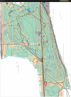
Mike and I drove up to Indian Cave state park in NE to explore his updated map. PTOC has a map of this park and we have orienteered there before. But he map was made before Lidar contours were available, so it is very generalized. Mike's map was much better.
This park is steep. The soil is loose. And it was the first warm sunny day (with no leaves) so the heat felt intense. And the hills were steep.
I still had fun. I took it super easy, and planned two loops so I could stop at the car and refill my water bottle half way through. I couldn't go to the first control because the trail was closed due to prescribed burns.
I was pleased that I could read the contours well. I was walking but the map is complex and not field checked, so I had to pay attention. I skipped 5 and 6 to get back to the car. I saw Mike just as I joined he main trail after 4, but then I didn't see him again.
The second loop was easier due to less steep areas, more road and ridge running, and some open areas. 12 and 13 were in a campground, and I got some weird looks as I went into the woods. I saw a group of turkeys as I was climbing out of 14.
This was a fun get-away day, even though we were both wiped out by the heat and the hills.
Mike has some photos on his log entry: https://www.attackpoint.org/viewlog.jsp/user_29/pe...
Thursday Apr 1, 2021 #
12 PM
weights 30:00 [3]
Workout 1: 5 rounds
1A: Body Weight Squat 1/2 full Reps x 15
1B: DB bent over Row x 15 (10s)
1C: DB Walking Lunge x 12@ (10s)
1D: 1 Arm Band Row x 15@
1A: Body Weight Squat 1/2 full Reps x 15
1B: DB bent over Row x 15 (10s)
1C: DB Walking Lunge x 12@ (10s)
1D: 1 Arm Band Row x 15@
2 PM
hike 30:00 [1]
with Sandy and Kiri at the dog park
Wednesday Mar 31, 2021 #
11 AM
orienteer 2:18:00 9.71 km (14:13 / km) +328m 12:10 / km
ahr:125 max:155
I wanted a long orienteering outing, so I went to SMP and did the day 2 Red course from our 2013 A meet. I started out at a decent pace (but not race pace, I knew I couldn't keep it up) but I slowed down a lot as the course progressed. The woods are much thicker after 7 years. And there are lots more bike trails, especially on the northern part of the map. It was beautiful spring day and I had the park mostly to myself.
Got pulled off my planned line from 3 to 4 (wanted to hit the trail, just didn't go far enough and made a parallel error).
Don't know what happened with 6, I just stopped reading the map. I remember telling myself to stay on the ridge and go to the top, and that's what I did but I shouldn't have.
I waved at 11 because I didn't feel like climbing up just to come back down.
I wasn't confident that I had found 13, so I circled back around to double check.
The woods around 14 and 15 are complete junk now, all downed trees and branches. The trails are also very different. So I missed 15 slightly, but close enough.
I decided to stop there and head back to the car, but I was brain dead and couldn't walk in a straight line LOL
Monday Mar 29, 2021 #
9 AM
orienteer 1:08:02 5.8 km (11:43 / km) +145m 10:25 / km
ahr:129 max:155
We got up fairly early due to the crowing rooster and clock tower chimes, and went for a nice breakfast. Then we headed to Turkey Mountain Park for some orienteering. Mike had made this map, too, so that I could add Oklahoma as my 41st O state. Thanks Mike!
This is a mountain bike area with tons of trails. I figured out right away that there were extra trails out there, but the map showed the main ones. The woods around 1 and 3 were fairly open; but the rest of the woods were really thick. So I stayed on trails almost the whole time The trails varied from smooth to very rocky. Some areas were pretty wet or running water. So I ran sometimes, walked others.
When I got to 3, I planned to go straight through the nice woods, but the hill was covered with huge boulders (only saw them in this area). I also looked at my watch and realized I didn't have time to get 4 (Mike and I agreed to be out 1 hour). So I moved onto 5.
I was confused at 6 because it was a pond, not an open area. And when I left it, I expected to find a 4 way trail junction and to go due south to 8 (decided to skip 7 to save time). But it was a three-way junction and there was no trail going south. Took the next trail over to the east instead.
There were a lot more trails than mapped on the way to 8 but I figured them out. And then I had to run straight back (and was even a few minutes late).
Beautiful sunny day, nice temps. I only saw one other person the whole time. This was a cool park and I'm so glad we went!
Sunday Mar 28, 2021 #
Note
Mike and I drove down to Tulsa. Since we've each received our first jab, we felt it was reasonably safe to travel and spend our first night out of the house since this whole thing started. So we booked an Airbnb for one night in Tulsa.
Stopped at https://www.woolaroc.org/ on the way down. The museum was bigger and more interesting than I expected.
Mike had made a map of the Oral Roberts campus (we had walked around there once before and knew about the interesting architecture). But due to Covid, visitors are not allowed on the campus, only able to stop and see the praying hands. We looked at the map as we walked from parking lot to praying hands and back.
We had a lovely Airbnb, on a wooded property with several other buildings and a huge lake. After dinner, we sat on the deck over the lake. I drank wine and enjoyed the view, while Mike painted the view.