Discussion: park/sprint mapping opinion please
in: Orienteering; General
Dec 14, 2014 12:53 AM
#
I'm working on a local park map which includes sportsgrounds bordered by a dense (ISSOM uncrossable) hedge, with a high (also ISSOM uncrossable) fence running through and/or immediately parallel. My instinct is that for the most part it's not necessary to draw both - what is the difference between one barrier and two?, nor would it make for good map legibility. So if the hedges and fences always matched perfectly I would just map one or the other, probably prioritising the hedge as that's the more distinctive visually.
However, they don't always match perfectly - there are some significant gaps in the hedges still blocked by the fence, and some of the gateways into the grounds are defined more by fencing than hedging (if that makes sense). SO: what's the general consensus out there on the best way to handle this? I can see the following options:
A) draw both wherever they occur, resulting IMO in a messy map, and as a result of the thick green line and thick black line, using up much more width than they do in the real world, which could constrain my ability to capture various other useful features near the hedge/fence.
B) draw the hedge only for the most part, but include short sections of fence where otherwise gaps would be indicated. This is my preference, but is this inconsistent mapping? It's intuitive to me, especially if the drawn fence always continued a few mm beyond the gap, but would it be intuitive to most?
C) draw the fence only - there are no instances where the hedge extends beyond the fence, so if just one or the other was to be mapped this is the more consistent. However like I've already said, for the most part the hedge is the more visible part of the barrier, there are places where coming from one direction at least you wouldn't even see the fence.
The one catch that would weigh me towards option C is that this is a map for local club use - most of our membership are a little 'isolated' from the national or global scene so might be less likely to recognise that a thick dark green line means 'you can't go through here' in the same way they might recognise the uncrossable fence symbol. But what better way to learn ;-)
So I'm leaning even more now towards option B than I was when I started typing, but would still appreciate some 2nd, 3rd, 4th... opinions before I commit. There's nothing I enjoy less than an unfair map - I'd hate to be part of the production of one!
Dec 14, 2014 1:36 AM
#
I would also lean towards B, and put something in the course notes/map notes explaining what you did -- that since the hedge essentially hides the fence (that's my impression anyway), that you just mapped the uncrossable hedge since that's more visible than the fence. When the fence is present w/o the hedge, then you map the fence to show that it's still uncrossable at that point.
Dec 14, 2014 4:41 AM
#
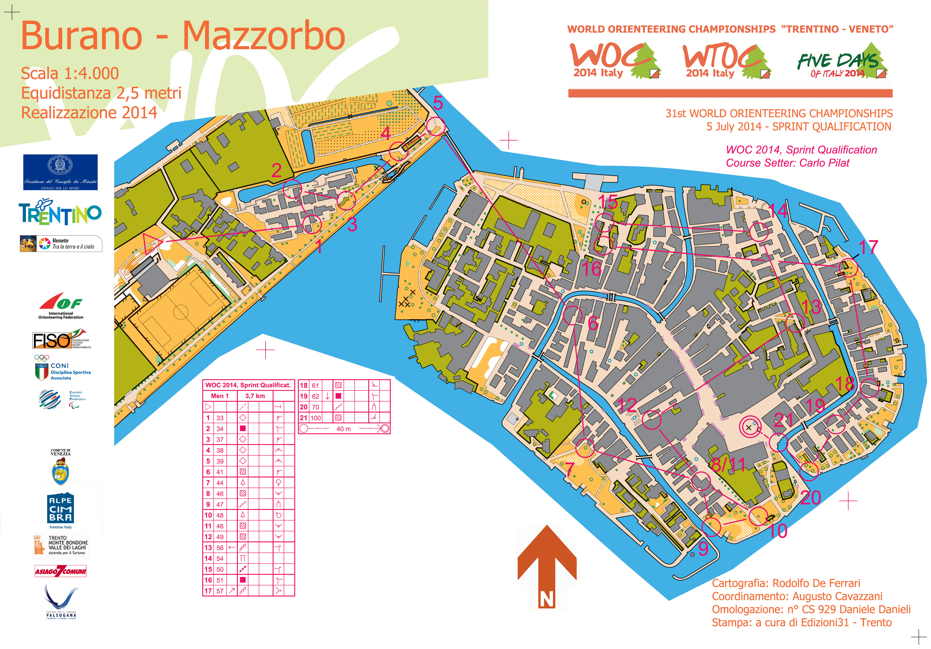
Near the start of the WOC Sprint Qualification race in Burano, Italy, there is a soccer, er football, field with an uncrossable fence around the perimeter. The map is here http://www.woc2014.info/LIVE/maps/sprintq/Burano-s...
If you look closely, you will see some green just outside of the uncrossable fence and if you look at street view on google, standing on the sidewalk southeast of the field and look at the field, you only see a hedge.
https://www.google.com/maps/place/Burano,+30142+Ve...
Here anyway, they mapped both
Dec 14, 2014 5:28 AM
#
"...and put something in the course notes/map notes explaining what you did.."
Could I suggest that if this is part of a mapping solution, it is not much of a solution.
On the other hand, in Sprint O and Trail O, this might be a plus, since it adds to the post event arguments.
Could I suggest that if this is part of a mapping solution, it is not much of a solution.
On the other hand, in Sprint O and Trail O, this might be a plus, since it adds to the post event arguments.
Dec 14, 2014 11:29 AM
#
As an ordinary consumer - if it's there on the ground it should be there on the map.
Dec 14, 2014 12:29 PM
#
C). Draw the feature which is *always* there first, then draw other stuff if you have room (which it sounds like you don't). Your option B would look really weird IMO.
Dec 14, 2014 1:21 PM
#
What do you want to tell the reader?
Sounds like there's a big, continuous uncrossable object, with occasional gaps so any solution should show that. Sounds like the uncrossable fence defines the gaps, so I'd say that that symbol is best.
If you need the hedge because it looks like a hedge, I'd add some green. probably actually the "fight, legal to cross" green because it contrasts better with the fence, and fits nicely in the double-tag side. The fence already tells the runner its illegal to cross.
I definitely wouldn't map fence-ends where there are no fence-ends. (B)
Dec 15, 2014 1:28 AM
#
I think as a runner, I would probably understand graeme's mapping the best out of all the options.
Dec 15, 2014 1:52 AM
#
I second Graeme's comment that, the "uncrossable" aspect is more important than on-site appearance, since the orienteer must make a critical route choice decision long before they view the feature(s) directly. If space only allows for one symbol, it should be the boldest, simplest, most common symbol. For those reasons I also vote for UC fence, first.
However, this situation doesn't sound unusual, and Carl's linked high profile example is hardly rare. We haven't seen the subject terrain or map, but I/we have seen plenty of tracks/athletic fields with hedge/fence combinations surrounding them, and viewed plenty of Sprint maps.
Bottom line, I find it difficult to believe that both objects cannot be clearly drawn completely to spec at 1:5000, to say nothing of 1:4000.
This is exactly what the ISSOM specs are designed to show, and usually do so without drawing a comment.
Oh, but I do like Graeme's idea of cheating on the green for contrast.
Dec 15, 2014 2:34 AM
#
Oh, but I do like Graeme's idea of cheating on the green for contrast.
Yeah, I like that idea too - it doesn't compromise route choice since the fence already blocks access perpendicular to the fence/hedge, and no one's going to run through a hedge long-wise. It would only be a concern if you could run *between* the hedge and the fence.
It does sound reasonable that both can't be displayed though - the uncrossable fence symbol covers 1.6m at 1:4000, and your average chain-link fence has effectively zero width.
Dec 15, 2014 3:31 AM
#
Oh god we're not going to go into the whole scale versus reality debate again are we :-) How big do those man-made features need to be again to justify the size of the symbol - wasn't is something like 6m?
Dec 15, 2014 3:44 AM
#
No, I have no intention of going into that debate - the uncrossable fence symbol is the width it is for a reason (so it's a whopping great black line that tells the runner unambiguously that they can't cross it) and that's a perfectly good reason.
However, that unavoidably leads to tradeoffs when mapping features near uncrossable fences that have no real-world "thickness". In this case, unless the hedge is significant in the terrain in some aspect other than as a linear uncrossable feature, IMO it should be left off as that aspect is already covered by the fence symbol.
However, that unavoidably leads to tradeoffs when mapping features near uncrossable fences that have no real-world "thickness". In this case, unless the hedge is significant in the terrain in some aspect other than as a linear uncrossable feature, IMO it should be left off as that aspect is already covered by the fence symbol.
Dec 15, 2014 5:55 AM
#
I also like Graeme's suggestion. If a hedge is what I would see in front of me, then I'd like to see a green line on the map.
Dec 16, 2014 8:37 AM
#
thanks all for the feedback, (yes, even you, tRicky) I think graeme's arguments have won me over, I will definitely have a bit of an experiment with overlaying the two symbols in such a way the hedge line sits nested in line with the fence 'tags'.
Dec 16, 2014 6:31 PM
#
I'd use graeme's solution as well.
The map linked above - http://www.woc2014.info/LIVE/maps/sprintq/Burano-s... - however is technically wrong, at least to my understanding of ISSOM.
The football pitch enclosed by the uncrossable fence is completely enclosed, and as thus is OOB. Thus the area enclosed by the fence should be shaded olive green as OOB.
As the map is drawn, the football pitch is excessive detail. That's my understanding of ISSOM anyway - am I wrong?
Dec 17, 2014 7:42 AM
#
The football pitch was being used also on the wamup map for the athletes. For the warmup, the pitch was very much open. Perhaps the officials decided to keep all the detail on the competition map as well, as the runners had already seen the area mapped in that way.
Dec 17, 2014 1:41 PM
#
I would normally draw a football pitch like that in olive green. Regardless, I would draw the lines of the football pitch in. It gives the athletes some context to what the fenced in olive green area is and therefor allows them to identify it on the ground that little bit quicker and know what to expect (for example there might be flood lights around the pitch which are visible from a long way away).
Dec 17, 2014 4:31 PM
#
@rf_fozzy am I wrong?
Strictly, it is allowed to use an overprinted crossing point to access an area enclosed by an uncrossible fence. So its OK for the OCAD mapper to allow for the possibility that the CONDES planner doesn't have a copy of the mapping software.
Strictly, it is allowed to use an overprinted crossing point to access an area enclosed by an uncrossible fence. So its OK for the OCAD mapper to allow for the possibility that the CONDES planner doesn't have a copy of the mapping software.
Dec 17, 2014 4:42 PM
#
I've actually used pitch markings to navigate before. For example, on the Burano map, if there were a control on one of the trees along the fence, I could say "I'll go to the 2nd tree beyond the center line.", instead of "9th tree along the fence".
Dec 17, 2014 9:10 PM
#
Whether the area inside an uncrossable feature should be shown as out of bounds or not has been giving me sleepless nights for years. Thank you for allowing me to get some rest at last.
Dec 17, 2014 10:51 PM
#
Ta, useful to know.
Quick Q, whilst on the subject of CONDES - is the functionality any better/easier than either Purple Pen or OCAD9
I tend to use PP normally - because it's very easy to use, but there are certain things it cannot do.
Currently fighting with OCAD to set a course, where the start of the course is a normal linear course, but then turns to a score course before a few controls to finish.
I've solved the problem by shrinking the connecting lines to nothing, but obviously when I make changes to the course in OCAD, it brings back all the connecting lines, which is a bit annoying....
Dec 21, 2014 7:36 PM
#
rm:
I agree with Graeme, Eric and Carl...both is best. Especially in sprint mapping, one is frequently faced with symbols that are bigger than reality...walls, fences, hedges, narrow passages, retaining walls, ditches, etc....and as a mapper one frequently needs to map in ways accommodate that. I think that a related interesting discussion would be how best to adjust or simplify nearby features to keep the map readable and sufficiently accurate for navigation, when using larger-than-life symbols.
On rf_fozzy's topic, is there any value in a mobile app (for smart phones or tablets) as a course setting aid? I'm studying mobile app development, and pondering whether as practice to develop such an app, primarily aimed at capturing control locations and descriptions while the course setter is in the field, with the assumption that the course setter(s) would subsequently fire up a desktop course setting app (OCAD, Condes, PP) at home to hone the details of the courses and their presentation (positions of course numerals, page layout, position of course descriptions if overprinted, gaps in connecting lines, etc.). The focus would be ease of data entry/capture (use of location services to help keep the map centered on the course setter in the field, perhaps "smart" suggestions for control description based on the features near the center of the control circle, etc.) Maybe a mode for aiding control placement or vetting (showing which control is next to place, which have been placed, estimated hour of completion, direction to next control, etc.). Designed to work well offline, given that a lot of orienteering terrain doesn't have cell service. Suggestions welcome. My apologies if there's already one...I browsed for orienteering apps on Google Play and App Store, and while there are lots, I didn't see one with this purpose, except perhaps a French one on App Store geared toward school orienteering, iiuc.) Maybe I'll start a separate thread.
On rf_fozzy's topic, is there any value in a mobile app (for smart phones or tablets) as a course setting aid? I'm studying mobile app development, and pondering whether as practice to develop such an app, primarily aimed at capturing control locations and descriptions while the course setter is in the field, with the assumption that the course setter(s) would subsequently fire up a desktop course setting app (OCAD, Condes, PP) at home to hone the details of the courses and their presentation (positions of course numerals, page layout, position of course descriptions if overprinted, gaps in connecting lines, etc.). The focus would be ease of data entry/capture (use of location services to help keep the map centered on the course setter in the field, perhaps "smart" suggestions for control description based on the features near the center of the control circle, etc.) Maybe a mode for aiding control placement or vetting (showing which control is next to place, which have been placed, estimated hour of completion, direction to next control, etc.). Designed to work well offline, given that a lot of orienteering terrain doesn't have cell service. Suggestions welcome. My apologies if there's already one...I browsed for orienteering apps on Google Play and App Store, and while there are lots, I didn't see one with this purpose, except perhaps a French one on App Store geared toward school orienteering, iiuc.) Maybe I'll start a separate thread.
This discussion thread is closed.