Discussion: removal of grave in ISOM 2017
in: Orienteering; General
Aug 18, 2017 7:58 AM
#
In ISOM 2017, the symbol "grave" is removed. However, graves are very common in orienteering maps, have a well-defined shape on the ground, and are paramount in navigation. Removal of the symbol will lead to difficult in redrawing all the existing orienteering maps with those.
How does everyone else deal with this issue?
How does everyone else deal with this issue?
Aug 18, 2017 8:33 AM
#
rm:
A black X might work? I've seen a rather small number of graves on North American maps (generally graveyard if anything), nor do I recall many on the maps I've been on elsewhere. Where do you find them common, and how do they appear in the terrain? Lone headstones, or something else?
Aug 18, 2017 8:56 AM
#
When ISOM 2000 was published, my national association immediately published a mapping guideline saying what is a grave
The below is an extract from the committee's meeting:
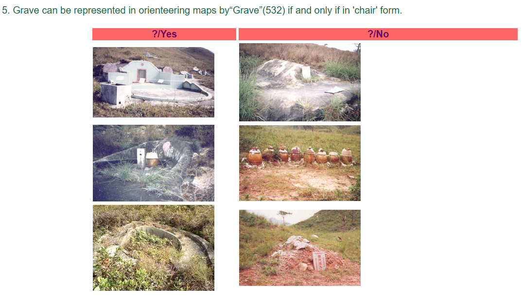
2.3 To draw the grave only if the area of the grave was less than 10m’s width. Paved area should be added if grave with paved area and larger than 10m . Grave should have chair shape with arms on both sides.
2.4 Shrine more than 1m high should be classified as building. Shrine less than 1m high and with urns only need not be shown on maps.
2.5 Deserted or dilapidated grave should be stated in "control description".
and here is an example where a region contains a lot of mapped graves
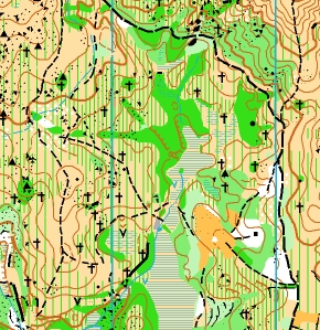
Digging graves on hills is the tradition of indigenous people here, so you can easily find them everywhere.
The below is an extract from the committee's meeting:
2.3 To draw the grave only if the area of the grave was less than 10m’s width. Paved area should be added if grave with paved area and larger than 10m . Grave should have chair shape with arms on both sides.
2.4 Shrine more than 1m high should be classified as building. Shrine less than 1m high and with urns only need not be shown on maps.
2.5 Deserted or dilapidated grave should be stated in "control description".
and here is an example where a region contains a lot of mapped graves
Digging graves on hills is the tradition of indigenous people here, so you can easily find them everywhere.
Aug 18, 2017 9:39 AM
#
Just keep the old symbol unless you plan using the map for an IOF event.
Aug 18, 2017 10:53 AM
#
if forced to use a symbol for IOF event, use cairn or monument symbol? 0.5m min height would probably be be satisfied by some part of the feature
526 Cairn
A prominent cairn, memorial stone, boundary stone or trigonometric point.
Minimum height: 0.5 m.
Footprint: 12 m x 12 m.
Colour: black.
We have a few isolated graves marked on local maps - usually one or two headstones, sometimes with a low metal fence around - usually early settlers who preferred to be buried on their property rather than in the nearest village or town
Aug 18, 2017 12:01 PM
#
It's going to present a problem in South Korea.
http://news.worldofo.com/wp-content/uploads/2015/1...
http://news.worldofo.com/wp-content/uploads/2015/1...
Aug 19, 2017 12:48 AM
#
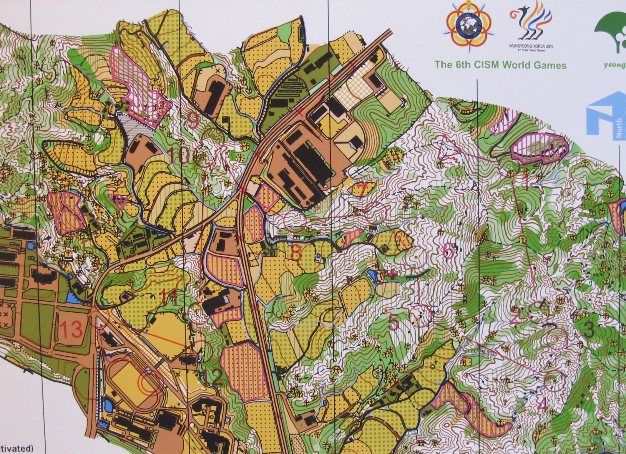
A small demonstration of the claim that the new ISOM fails to meet the challenge of providing world-wide utility.
Aug 19, 2017 2:25 AM
#
Graves are common on many of the best Hong Kong orienteering maps (miklcct's extract looks like it could come from a Hong Kong map). They are scattered over the the open hillsides throughout Hong Kong's country parks. If I recall correctly, one of the maps used when Hong Kong hosted APOC had something like 600 graves on it. That can also make them one of the most useful control features on some maps. They vary a reasonable amount in size, I guess depending on the wealth of the family and/or how many family members / generations are buried there, some quite small, some slightly more expansive semi-circular monuments, but generally they would be just point features.
Aug 19, 2017 7:32 AM
#
I've seen a draft of ISOM301X, and there's no vegetation. Apparently its disrespectful to ents.
Aug 22, 2017 9:03 PM
#
Another symbol that seems to have disappeared is the stairway of which there were two options in ISOM 2000. What is with that? Also the differentiation between paved with traffic and paved without vehicle traffic. What?
Aug 22, 2017 11:58 PM
#
Those two things you mention were in a section called 'Mapping Guidelines for Park Orienteering'. 2000 was when Sprint O was just starting (from an IOF perspective at least - Park World Tour was going strong and had their own mapping standards). The first WOC Sprint was 2001. There was no ISSOM then, that was still some time away. So a few park map symbols were added to ISOM to fill the gap. While not explicitly stated those park symbols were never intended to be used for normal forest maps ( that section recommends 1:5000 for park maps). Once ISSOM came along that section was effectively redundant. There was some discussion about the issue of traffic/no traffic symbols in ISSOM but the MC decided not to go down that path (see section 2.4 of ISSOM 2007) instead they used different shades of brown for urban and non-urban.
Note: there are also MTBO and Ski O sections in ISOM 2000 which are now handled in separate documents. Presumably you are not also lamenting the loss of the 'road covered with snow' symbol (804) in ISOM 2017.
Note: there are also MTBO and Ski O sections in ISOM 2000 which are now handled in separate documents. Presumably you are not also lamenting the loss of the 'road covered with snow' symbol (804) in ISOM 2017.
Aug 23, 2017 2:10 AM
#
Rob,
Rob, I have found a popular way to get around the road covered with snow issue. I leave Canada and go to Florida from late October to mid-April.
It is easy enough to copy old stair symbols in to new map standards and I will do that. Crazy but it seems someone somewhere is presuming ISOM maps will not occur in urban areas. However I have come across and mapped university campuses in the States and Canada that are so large and spread out they are not tight enough for Sprint and they are very suited to the 1:10,000 or 1:7,500 scale meant for 'forest maps'.
The beauty of the IOF inflexibility on mapping standards is that they drive many of us out of even trying to reach their standard and thus gives us more flexibility to do it our way. I'm guessing by the current scarcity of national events across America that a lot of others are thinking the same way.
Aug 23, 2017 4:07 AM
#
I was about to comment on drawing stairs to scale but then realised this was ISOM, not ISSOM.
Aug 23, 2017 7:50 AM
#
coti:
Totally agree with gordhun. I would add that as long as ISOM standards are imposed only for some and others are left to do what they want, we have a big problem.
@ robplow: It's not the fact that some symbols disappear and others completely unnecessary appear embarrassed but the lack of coherence and logic.
A few years ago, ISOM's approach to ISSOM was discussed, but it seems that this path has been abandoned. For me it's ok because it's much more logical to get ISSOM close to ISOM, not vice versa. Not having 2,3,4 or 5 different standards it simplifies the maps but just one strong rule and easy to apply. Now,even Trail maps want to have their standards...
We should have only one standard for all maps: ISOM. I regret ISOM 1990 or even 2000, examples of simple efficacy.
Do not expect ISOM 301X to solve problems.
Aug 23, 2017 8:12 AM
#
Back in the late 70's I did my first orienteering tour of Europe. There were no map standards, but it didn't really bother me. UK - 4 events in different regions, each map was unique, Austria 3-days - all 3 maps to the same standard but different to the UK and Australia, Hungary 5 days - every map completely different symbols, colours and standards. Swedes were near the top in Austria and Hungary despite the poor quality of the Hungarian maps.
With splitting of WOC, I think we do need both ISOM and ISSOM, but the latter needs updating. If you are mapping for a local event, I don't see that you have to strictly follow IOF standards, and if a particular non-ISOM symbol would be useful then use it.
With splitting of WOC, I think we do need both ISOM and ISSOM, but the latter needs updating. If you are mapping for a local event, I don't see that you have to strictly follow IOF standards, and if a particular non-ISOM symbol would be useful then use it.
This discussion thread is closed.