Discussion: Fires in the West
in: Orienteering; General
Sep 7, 2017 12:32 AM
#
With smoke in the air, drifting into Minnesota air from far, far away, I have to think of all the beautiful forests out West, being eaten up tree after tree, acre after acre...
Hoping for everyone in our O community (all others of course, too) being safe, out of harm's way. Maddening when careless humans do this to our beautiful planet.
From an orienteers point of view I also hope that not too many maps have to be redrawn because of forests and parks lost to the flames.
Hoping for everyone in our O community (all others of course, too) being safe, out of harm's way. Maddening when careless humans do this to our beautiful planet.
From an orienteers point of view I also hope that not too many maps have to be redrawn because of forests and parks lost to the flames.
Sep 7, 2017 1:03 AM
#
CascadeOC's maps in the Teanaway Valley (home to many big events over the years) are currently on fire. As of today, the burned areas on the map are pretty small, but the fire is 0% contained, so its possible that we'll lose more/most/all of it.
Salmon La Sac is just west of the fire, but it looks to be ok, but if the winds change...
Salmon La Sac is just west of the fire, but it looks to be ok, but if the winds change...
Sep 7, 2017 2:24 AM
#
Was it deliberately lit? We get the same issue in Aus every time summer comes around and I wonder what is wrong with people.
Lane Cove NP in NSW has just been burnt out and I know that has O maps of it. That's in Australia's east though so probably doesn't belong in this thread, which is about the west.
Lane Cove NP in NSW has just been burnt out and I know that has O maps of it. That's in Australia's east though so probably doesn't belong in this thread, which is about the west.
Sep 7, 2017 3:23 AM
#
undy:
I was in LCNP this morning, the fire is only a small bit at the top end - I turned up the road to the caravan park and still hadn't seen anything (apart from some park closed signs).
...and as I type this I see that it has flared up again according to the interwebs.
...and as I type this I see that it has flared up again according to the interwebs.
Sep 7, 2017 3:54 AM
#
rm:
Some of the past fires near here were set. Having said that, the natural state of the forest is with lots of burn scars, not totally forested as now. Maps of my part of Colorado from the 1800s showed numerous, vast burn scars, maybe a third of the area by my eyeball as I recall from seeing them in a museum. In Banff (Canadian Rocky Mountains), photos from long ago show lots of burnt area, compared to nearly complete forest cover nowadays. Burns are normal, and some species need them for propogation, or for killing off competitive species.
Sep 7, 2017 3:56 AM
#
rm:
The smoke here has thinned enough that I can see Pikes Peak, and the Moon is only orange not red.
Sep 7, 2017 4:30 AM
#
The Jolly Mountain fire, which is the one burning our orienteering maps, was caused naturally. The nasty one in the Columbia Gorge (WA/OR border) was caused by some teens lighting fireworks.
Sep 7, 2017 4:46 AM
#
Lightning is the most common cause of western North American fires. I recall when I visited Yosemite there were no fewer than seven thunderstorms during the day; storm number 3 started a small fire and storm number 4 put it out.
Eucalypt forests (the most common type in Australia) have evolved to survive fire and regenerate after it. This means it's usually possible to orienteer again in them within a few months of a fire (if you're not too concerned about the accuracy of the green on the map), but sometimes the regrowth ends up being too thick to be usable.
Eucalypt forests (the most common type in Australia) have evolved to survive fire and regenerate after it. This means it's usually possible to orienteer again in them within a few months of a fire (if you're not too concerned about the accuracy of the green on the map), but sometimes the regrowth ends up being too thick to be usable.
Sep 7, 2017 5:38 AM
#
I have seen some news photos of fires in western North America where the fire is just along the ground and not damaging the tree cover. That has to be good for orienteering even though one might have to temporarily take some green off the map.
In some of the Suncoast Orienteering areas we count on 'prescribed burns' to open up terrain for off trail route choices.
In some of the Suncoast Orienteering areas we count on 'prescribed burns' to open up terrain for off trail route choices.
Sep 7, 2017 6:11 AM
#
bmay:
I don't have any real expertise in this area. But, in BC, I understand about half of our forest fires are caused by natural causes (i.e., lightning) and half are human-caused. Compared with historical times, we have more fires, but we also put many of them out as an enormous amount of resources goes into fire suppression. Overall, I believe less forest is being burned each year than used to be the case. This year is particularly bad, but still only about 1% of the province has burned. I believe a once in a 100 year burn is probably good for the overall health of the forest and is definitely a natural part of the cycle.
Sep 7, 2017 8:47 AM
#
We have a few maps near each other that need burning regularly as they are unusable. We've not used them now for over five years but sadly no fires and we can only use them for 2-3 years afterwards before it becomes too yucky again.
Sep 7, 2017 10:50 AM
#
Harriman State Park (site of WOC93) has had fires many times, including during the 1989 Team Trials. Fires there typically burn just the low-lying vegetation or even just the dry leaves on the ground, and aren't much of a factor for orienteering.
Some of the maps in Colorado used for the original 1000-Day events were hit by one of the biggest forest fires ever in the USA. I visited the burned area a year or so later, and it was weird, you woudn't necessarily know that a fire had been there, some trees were unaffected while others were completely burned up and gone, leaving just a hole in the ground where the roots used to be.
The effects of fire can vary, and can sometimes be pretty adverse (from our perspective) for a forest, but that isn't necessarily the case. It doesn't affect rock, and may not afffect contours. Here's hoping that the Teanaway fire just burns out thick vegetation.
Sep 7, 2017 11:08 AM
#
GuyO:
IIRC, a fire in the SE part of the Silvermine map burned the canopy; within a year or two, the ground in that area was nearly impassable.
Sep 7, 2017 11:29 AM
#
GuyO Yes that is the flip side. Anything that destroys a complete tree canopy - fire, ice storm, etc) will let more sunlight through to the forest floor and will generate new growth and lots of it. That will take place until the new growth gets large enough to again block the sun from the forest floor. Unfortunately some of the new growth that moves in after a fire is invasive stuff that blocks the maples, beech, ash and oaks from even getting started.
Thanks to ice storms in 1998 and about 10 years ago those running the retr-O course at the Canada 150 O Festival faced somewhat thicker woods (and more stinging nettle) than did the orienteers of 1968.
Thanks to ice storms in 1998 and about 10 years ago those running the retr-O course at the Canada 150 O Festival faced somewhat thicker woods (and more stinging nettle) than did the orienteers of 1968.
Sep 7, 2017 8:08 PM
#
rm:
I was just hiking in the Hayman burn scar, which is what I'm guessing JJ may be referring to. After a couple decades, it's still mostly open, with some areas of low aspen. But the topography and rocks are still there. There are places in nearby forest where an area ten meters across burned amidst otherwise undisturbed forest, presumably due to some ember from the big fire. Entirely preventing fires because people like unburnt forests for recreation isn't necessarily the best for the forest and society given all factors. But it's why we have the forests that we do today, and the high fuel loads.
Sep 7, 2017 8:49 PM
#
Burns are normal, what is not normal is the casualness in those who toss a cigarette out of the car, decide that fireworks should just be tossed down into the ravine, a fire not put out properly or stuff like that. Cooperating with authorities is one thing, but I hope the consequences for those acting carelessly or willfully indifferent are more than just fines or possibly jail time, but having some really meaningful manual work in the communities they harmed added to their sentence.
Sep 7, 2017 11:11 PM
#
rm:
Two men whose campfire near Nederland Colorado got loose and burned a neighborhood were charged with a felony last year. However, as search and rescue, we often have to help put out the campfire or "signal fire" of subjects, sometimes on pleasant summer afternoons. Maybe there's too much of the "ten essentials" of wilderness preparedness. Or maybe it's survival shows on TV.
Sep 8, 2017 8:25 PM
#
I've been in the Pacific Northwest for nearly a month now, making me acutely aware of the most obvious short term consequence of so many fires: air quality. One online map shows over a thousand fires; while many are small and/or already extinguished, there are quite a few large fires out here still going strong.
It was especially bad in the Bend, Oregon, area for Deschutes Daze. Some entrants turned around and went home, and the organizers seriously considered cancalling certain races or even the whole event.
At times the visibility has been down to less than a quarter mile, reminding me visually, as a New Englander, of a foggy day on the Maine coast. But inhaling particles of ash is considerably less pleasant than inhaling droplets of water! On some days every exposed surface has gotten a coating of ash. I'll be returning east shortly with a renewed appreciation for our relative abundance of water.
But in a refutation of Murphy's Law, the spot my sons picked for eclipse watching (a few miles north of Mt Jefferson) was perfectly situated with respect to the fire locations and wind direction on that particular day, such that August 21st has been the one and only crystal clear day I have experienced out here this trip.
Sep 9, 2017 7:14 PM
#
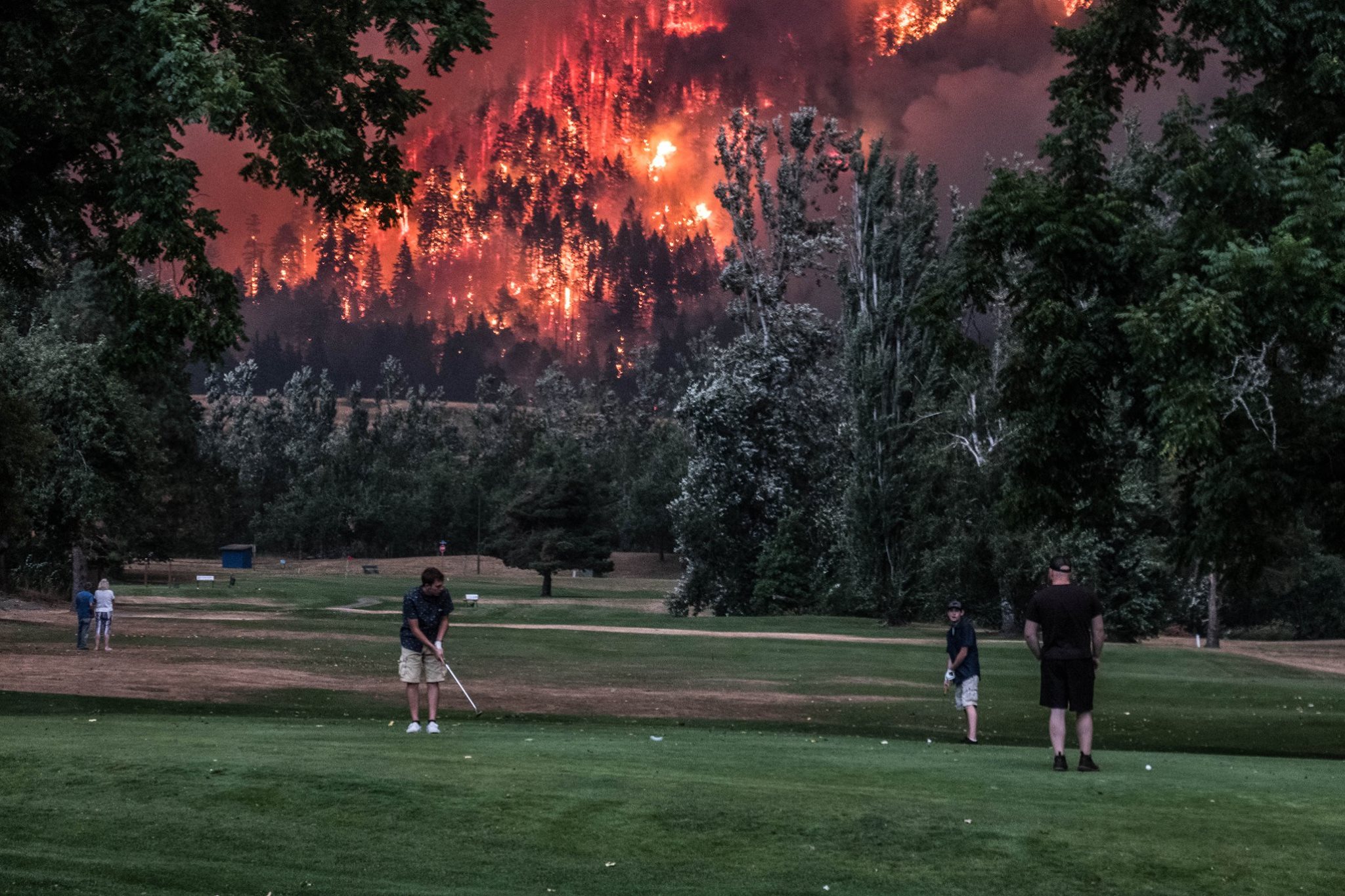
Every day the scenes become more shocking. I like the scene (shown below) of the golfers nonchalantly putting...while the whole hillside above them explodes in flames!
But contrary to some assumptions, regrowth is not a foregone conclusion in our carbon-enriched atmosphere. According to this NYTimes article, many areas of the West have never regrown:
...The hills here are beautiful, a rolling, green landscape of grasses and shrubs. But it is starkly different from what was here before: vast forests of ponderosa pine....
...The result is bad news for forests here, in the West and around the world. A planet with fewer trees is less able to fight climate change, because trees absorb carbon dioxide from the atmosphere as part of photosynthesis. The future in a lot of places is looking shrubbier...
For a real personal look at what western homeowners are confronting, here is a long vlog of a guy in the California foothills last month, recording the futility of fire fighters. It begins with a heroic home owner trying to save his house in the hills with a green garden hose...until an air tanker dumps a load of pink fire retardant onto his head.
Sep 10, 2017 1:22 PM
#
As one retweeter of this scene declared: "In the pantheon of visual metaphors for America today, this is the money shot."
Sep 10, 2017 5:37 PM
#
More forestry. Alternatively, don't worry about it. Private insurance, caveat emptor, and no moral hazard. Build next to the ocean or surrounded by chaparral? Eventually something bad is going to happen. OK--I've dropped the pot stirrer. Out.
Sep 10, 2017 6:07 PM
#
Those of you who orienteered at Boggs Mountain State Demonstration Forest before the fire two years ago may be interested in this recent article with several
pictures.
http://www.pressdemocrat.com/news/6950668-181/rest...
pictures.
http://www.pressdemocrat.com/news/6950668-181/rest...
Sep 10, 2017 6:25 PM
#
rm:
A small orienteering terrain east of Edmonton burned, and it took a long time before orienteering there was pleasant. Maybe we just need to route these rainy storms up to the other side of the lower 48.
Sep 12, 2017 12:17 PM
#
The NYT article that Clark links to is very well written and includes quotes from several very well respected wildfire and ecosystem dynamics scientists. These 'tipping point' fires that result in ecosystem regime shifts are becoming more common and the implications for watershed and landscape management are complex (and likely costly). This is especially true when these catastrophic fires are coupled with other extreme events (rain, drought, etc.). For example, recent fire and rain "double whammies" in Colorado and Alberta have put massive pressures on the fresh water drinking supplies. Increased sediment load, dissolved organic carbon concentrations, nutrient pulses, etc. are overloading downstream water treatment plants and/or reservoirs. Couple that with the air quality issues with smoke and the health implications of mega fires are large. For example (and linked closer to my own research), over 3,000 people died in the 2010 Moscow peat fires due to air quality. The estimates of deaths for catastrophic peat fires in Indonesia are an order of magnitude (or maybe even two) higher than that. This is a problem that is only going to get worse.
Oct 10, 2017 2:55 PM
#
Thanks Hammer. Many additional considerations of which some of us may not have been aware. For instance, I'd never even heard of the 2010 peat fires. Very sobering.
But nothing compared with the devastation going on out in California this week. Here are 43 pictures (bottom of article) of the Santa Rosa devastation. From the map shown, it looks like Annadel Park is also completely burned...one of the best orienteering maps in California. What a shame!
But nothing compared with the devastation going on out in California this week. Here are 43 pictures (bottom of article) of the Santa Rosa devastation. From the map shown, it looks like Annadel Park is also completely burned...one of the best orienteering maps in California. What a shame!
Oct 10, 2017 3:22 PM
#
One of the best maps, but it's been a long time since off-trail use was allowed, so not much orienteering has happened there recently.
Oct 10, 2017 4:50 PM
#
I can't believe the pace of these fires.
This article was in the NY Times magazine a few weeks ago, about how a huge amount of the firefighting in CA is done by incarcerated people, who receive very little pay and relatively small amounts of training compared to fully trained firefighters. It seems like a program that does a huge amount for these people personally, but it feels like they should be compensated more for the huge danger they're in.
They also can't go into careers as firefighters on release, as most crews don't accept felons. It's a really well written article.
https://www.nytimes.com/2017/08/31/magazine/the-in...
Oct 10, 2017 6:32 PM
#
I can believe the pace of those fires. There have been a number of occasions in Australia where fires have travelled 50km or more within the space of a few hours, as well as generating spot fires from burning 'embers' (often quite large bits of timber) ahead of the fire - in Canberra in 2003 one such fire destroyed two houses 12km ahead of the main fire front.
Oct 10, 2017 11:04 PM
#
We're lucky round here - they only go at the speed of a chairlift:-((
http://www.radionz.co.nz/national/programmes/check...
http://www.radionz.co.nz/national/programmes/check...
Oct 10, 2017 11:42 PM
#
rm:
Luckily, moisture has helped my part of Colorado avoid fires (rain, fog, now snow). I have noticed, however, that the lost hikers that my SAR unit rescues, tend to lack a map from the Ten Essentials to carry when in the back country, but seem to remember the ability to build a fire upwind from my house. I wish that they could be convinced that the map is essential, not just fire. Maybe it's all the TV shows showing people making fire.
Oct 11, 2017 1:19 AM
#
This article was in the NY Times magazine a few weeks ago, about how a huge amount of the firefighting in CA is done by incarcerated people, who receive very little pay and relatively small amounts of training compared to fully trained firefighters.
Would be ironic if they were incarcerated for arson in the first place. Might put some sense into them.
Given how much it costs to keep prisoners in jail in Australia, paying them to do 'hard labour' would just be yet another burden on the law abiding, taxpaying public.
Would be ironic if they were incarcerated for arson in the first place. Might put some sense into them.
Given how much it costs to keep prisoners in jail in Australia, paying them to do 'hard labour' would just be yet another burden on the law abiding, taxpaying public.
Oct 11, 2017 3:01 AM
#
Tonight in Northern California, a portion of Annadel State Park in Santa Rosa has caught fire, threatening the adjacent Oakmont Retirement Community. The BAOC Annadel map was used for 2 US Championships in the past. Access to Annadel has been restricted the past ten years and we have only been able to use it once about 4 years ago.
Of course the big ongoing story is the hundreds of homes being destroyed in the Sonoma and Napa Valleys in the past 2 days. The air has been quite smoky 40 miles south here in Berkeley.
Of course the big ongoing story is the hundreds of homes being destroyed in the Sonoma and Napa Valleys in the past 2 days. The air has been quite smoky 40 miles south here in Berkeley.
Oct 11, 2017 3:53 AM
#
The wind coming across the Central Valley Sunday night was incredibly strong - some of the strongest non-srorm wind I've ever experienced. No wonder the fires spread so fast.
Oct 11, 2017 4:26 AM
#
You pay to keep prisoners in jail because as a law abiding person your society has decided you want them separated out... that wasn't their choice really.
If people work pay them and train them fairly for the work. I don't care how they came to be doing the work but prisoner or not work should be valued or the ethics of the whole system start to really fall apart when the "law abiding citizen" is benefiting from abusing prisoners.
Doesn't leave the LAC much of a leg to stand on morally.
Oct 11, 2017 8:42 AM
#
My daughter lives in Santa Rosa, 1 mile south of the evacuation line and 3 miles south of the worst of the devastation. So far she is doing fine in place, managing a bunch of pets that belong to friends who lost their homes, ready to leave at a moment's notice if she needs to, but it seems the worst may be over.
Oct 11, 2017 12:21 PM
#
Thanks for the news, Charlie. I thought about your daughter and hoped she was okay.
Oct 12, 2017 4:07 PM
#
From this satellite tracking map, it appears that the southern half of Annadel SP is now burning. https://ww2.kqed.org/news/2017/10/09/map-track-the...
Oct 12, 2017 10:19 PM
#
Erin was on a JTESC call on Tues. but didn't talk about how close the fires were to him.
Oct 13, 2017 12:48 AM
#
Trinka Gillis (former BAOC President) and Bjorn Widerstrom and their family have evacuated from Sonoma.
Oct 13, 2017 10:39 AM
#
How is the air quality in El Cerrito this morning? Are you wearing face masks to avoid the 'fine particulates' that apparently go directly into the blood stream?
Oct 13, 2017 12:48 PM
#
The smoke levels vary with the wind direction, It is still dark and not too bad this morning. We were awakened by the smoky air on Sunday night. Since then I pretty much stayed inside. When I go out my eyes have burned and throat becomes congested. Masks are being worn by many people, but not all. Leslie had jury duty and was forced to sit in a smoky smelling building in Martinez. We are flying to San Diego today, a previously planned trip to visit out daughter’s family, So we get a respite. Psychologically N.Cal is in a pall.
Oct 13, 2017 1:40 PM
#
Good move. Enjoy your respite. But the NYTimes this morning has some sobering information on the physical damage done when smoke from burning buildings, plastics, and man-made materials fills the air. For instance, normal face masks don't do the job:
....Certain masks can filter out fine particles, but surgical masks are useless, and so are the ones used to protect against big particles. The masks that work are a type called N95, available in many hardware stores.....[because] heavy smoke can include toxic substances emitted when man-made materials burn. Plastics can release hydrochloric acid and cyanide.
“Smoke inhalation can kill you,” Dr. Balmes said. “There’s no doubt about that...If you breathe in a lot of smoke from a fire in a building with man-made materials that can emit these toxins, you basically have chemical burns of the airway. Just like your skin can slough off when it’s burned, the airway lining can slough off. It can be life-threatening. People have to be intubated and put on a ventilator...."
Oct 13, 2017 3:31 PM
#
As it happens, I'm currently working on compiling lists of major weather-related disasters in 2017 for the annual global climate statement. From the information that I've got hold of so far, the loss of life from this fire appears to be the largest for any wildfire in the US since 1918 (and that's without counting indirect deaths triggered by smoke pollution, of which there will probably be some).
Oct 13, 2017 3:37 PM
#
The count will be rising, as over 400 people are missing. These fires are still expanding.
Oct 16, 2017 3:55 PM
#
Meanwhile, it looks like some (perhaps most) of the 2008 WMOC maps in Portugal have been burnt in the last day or two:
http://www.severe-weather.eu/news/wildfires-in-spa...
If I recall my geography correctly, I think the town in the foreground of the first picture is where the sprint final was.
http://www.severe-weather.eu/news/wildfires-in-spa...
If I recall my geography correctly, I think the town in the foreground of the first picture is where the sprint final was.
Dec 7, 2017 4:34 PM
#
Another round of western fires this week. Here's a long video from our fire-chasing friend who has entered the wealthy but evacuated Los Angeles golf suburb around the Angeles National Golf Course in the San Fernando Valley, and watches the advance of 'Creek Fire #4' as fire crews arrive, and 'fire brands' drop from the skies:
https://www.pscp.tv/EPN564/1nAKEWVQdzoJL
Very striking sequence around 9:40 as the photographer attains the ridge-top and encounters the Santa Ana gale-force winds. And another sequence as the tall Lombardy pines planted tastefully around an apartment complex burn like blow-torches at 15:00 and ignite the whole complex. A Hellish scene.
This discussion thread is closed.