Discussion: First 5-Colour Maps
in: Orienteering; General
Oct 23, 2017 8:44 PM
#
While looking up something else, my mind started to wander. Does that a lot lately.
I wondered when were the first 5-colour orienteering maps made.
The earliest example in North America that I know of is the map made for the 1975 Canadian Championships in the Dundas Valley, Hamilton. Field work and drawing by Jack Lee and Steve Pearson. Is this the earliest in NA?
When were they first made elsewhere?
Oct 23, 2017 9:40 PM
#
This map of Ward Pound Ridge says it was created in 1971 so would pre-date Dundas Valley by a bit. HOWEVER I suspect the green was added later, at least after the US Champs there in 1972. I wish you had asked the question four days ago when I was home with my 48 binders full of orienteering maps going back 49 years.
Oct 23, 2017 9:52 PM
#
I believe more likely than not that green was on the original map, and not added later. (As a side note: it wasn't used to show thick vegetation.)
Oct 24, 2017 7:24 AM
#
That Ward Pound Ridge map looks so nice and readable (though I think it would be a bit of a shock to run on 1:20,000). Would the current vegetation make it hard to use today? Does someone have a recent version to compare with?
Oct 24, 2017 8:58 AM
#
This year's Billygoat was at Ward Pound Ridge, so the current map can be found online such as at Valerie's RouteGadget site. I'm sure that some of the farther reaches of the 1971 map are omitted from the 2017 map.
Oct 24, 2017 3:55 PM
#
Effectively the green for the "Hemlocks, pines or other evergreens" on the 1971 WPR map was the same as a green for thick running as most of the spots were young plantations. However I suspect the larger 'blob' in the lower center of the map was a stand of hemlocks that were not logged away in the early days as hemlock had no commercial value. That stand is virtually all White on the 2017 map.
So I agree with GHOSLO that the 1971 WPR map doesn't beat 1975 Dundas Valley for the first 'green jacket' award.
That Fall of 1975 was a real treat for orienteering in Ontario with the Ontario Champs staged by Jim Gilchrist on his new map of the Haliburton Scout Camp then followed two weeks later by the COCs in Hamilton on the Dundas Valley map. Both events were featured in the Toronto Globe&Mail, Canada's equivalent to the New York Times, with half page spreads including photos.
Oct 24, 2017 8:07 PM
#
I'll almost guarantee that the laurel represented by green on the current WPR map was already there by the early 1970s.
Oct 24, 2017 10:32 PM
#
Besides GHOSLO's initial post did not specify what the fifth colour (color) was or what it was meant to represent. So I am reversing direction and saying WPR 1971 was indeed the first 5-colour (color) map in North America.
Oct 24, 2017 10:55 PM
#
On May 24-25, 1975, the New England Orienteering Club held the NAOC at Bear Brook SP, NH, on a new 5-color 1:15,000 map.
D19A-: 1 Irene Jensen, Viking; 2 Pamela McIntosh, Niagara; 3 Sheila Mitham, Montreal
H21A-: 1 Ted de St. Croix, Niagara; 2 Gordon Hunter, Ottawa (remember?); 3 Thom DeBuys, Quantico
D19A-: 1 Irene Jensen, Viking; 2 Pamela McIntosh, Niagara; 3 Sheila Mitham, Montreal
H21A-: 1 Ted de St. Croix, Niagara; 2 Gordon Hunter, Ottawa (remember?); 3 Thom DeBuys, Quantico
Oct 24, 2017 11:42 PM
#
Dundas Valley was definitely not the first.
Here is the Bear Brook map
www.petergagarin.org/1975/19750524(nac1).jpg
Here is the Bear Brook map
www.petergagarin.org/1975/19750524(nac1).jpg
Oct 24, 2017 11:44 PM
#
Here is a fixed version of that link:
http://www.petergagarin.org/1975/19750524(nac1).jp...
http://www.petergagarin.org/1975/19750524(nac1).jp...
Oct 25, 2017 1:31 AM
#
How about the Norwegian-made(?) map of Pocahontas State Park in Virginia made for the CISM World Champs. Wasn't that 1975?
Oct 25, 2017 1:52 AM
#
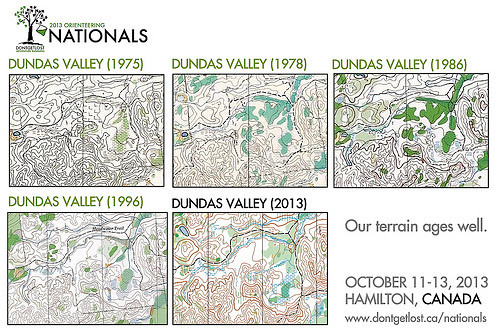
See how the Dundas Valley map changed over the years.
1975 Canadian Champs
1986 World Cup
2013 Canadian Champs
1975 Canadian Champs
1986 World Cup
2013 Canadian Champs
Oct 26, 2017 4:31 PM
#
bubo:
That Fall of 1975 was a real treat for orienteering in Ontario...
I can second that opinion since that was my first visit to Canada and I still have very fond memories of that time - both orienteering-wise and my stay with the de St.Croix family in Vineland.
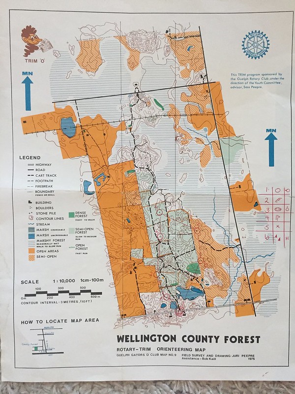
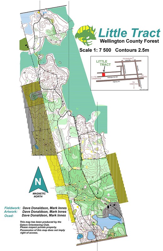
Ran on the maps in Haliburton and Dundas Valley - also on another 5-color map in Wellington County Forest near Guelph.
Edit: The Guelph map was from 1974.
I can second that opinion since that was my first visit to Canada and I still have very fond memories of that time - both orienteering-wise and my stay with the de St.Croix family in Vineland.
Ran on the maps in Haliburton and Dundas Valley - also on another 5-color map in Wellington County Forest near Guelph.
Edit: The Guelph map was from 1974.
Oct 26, 2017 5:25 PM
#
Bubo: That reminds me. I was intending to scan and send you a photo taken in 1975 by Pat de St Croix. It featured the 'international' participants at a Niagara Orienteering Club event that year. Besides you and Jan there was a guy from Australia, a couple from Rochester (Drexhage?) and Jackie Nichols of Nova Scotia. (I don't know how Nova Scotia qualified as international but she is there.).
I found the photo during my summer purge, put it aside to scan and then the scan pile got too big and I didn't get a round tuit. Now I'm south for the winter so look for it next spring.
I found the photo during my summer purge, put it aside to scan and then the scan pile got too big and I didn't get a round tuit. Now I'm south for the winter so look for it next spring.
.jpg)
Oct 28, 2017 2:37 PM
#
Gordhun - any chance of finding out who the Aussie guy was? (Slight chance it could be my Dad)
Oct 28, 2017 5:27 PM
#
bubo:
@gordhun
That must have been from the event in 1976 before the Quebec O-ring in Lachute. In 1975 I'm pretty sure I was not accompanied by Jan.
That must have been from the event in 1976 before the Quebec O-ring in Lachute. In 1975 I'm pretty sure I was not accompanied by Jan.
Oct 28, 2017 10:04 PM
#
Steve, Yes, I think there is a name with the photo but if I were to take a wild guess it would be something like Watson. I'll let you know in April.
Bubo, yes it could be '76 but at least I'm sure about the Niagara part. But for all you have not changed it could be '06.
Bubo, yes it could be '76 but at least I'm sure about the Niagara part. But for all you have not changed it could be '06.
Oct 29, 2017 2:45 AM
#
The first 5 colour map in Ireland was at Ballyward, Co Wicklow on 2 December, 1972. This was the unofficial Irish Championships won by Paget McCormack and Ruth Lynham. Amazingly, Ruth finished 6th in this years W21 Irish Championships (AP name routhe): 45 years at the top!
Nov 1, 2017 1:49 AM
#
I located the CISM (Consul International du Sport Militaire) maps over Pocahontas SP and Fort A. P. Hill in Virginia. Both say that they were field checked in the spring of 1975 by an US/Norwegian/Swedish team and made for the 9th Championships - so likely used in 1975, Eric W. Since the 1st was held in 1965, some year must have been skipped.
I volunteered to a last minute rescue of the 1977 USOC by setting the courses for Dec 3-4 at Pocahontas SP. Good terrain for a non-glaciated area. Phil Menagh (†), USMC/Quantico was MD and vetter. I surely had all map as carry-on attached to me when I flew down to Richmond
I volunteered to a last minute rescue of the 1977 USOC by setting the courses for Dec 3-4 at Pocahontas SP. Good terrain for a non-glaciated area. Phil Menagh (†), USMC/Quantico was MD and vetter. I surely had all map as carry-on attached to me when I flew down to Richmond
This discussion thread is closed.