Discussion: Simple way to explain Grid North to 12-14 year olds?
in: Orienteering; General
Oct 30, 2017 11:59 PM
#
As kids deal less and less with paper maps, orienteering dealing with magnetic north, and GPS having settings where you can chose between magnetic north display and true north, is there still a need to explain grid north to this digital generation? Do they even have a need for it if they will tend to not use paper maps beyond the one field trip experience in orienteering, no matter how much you recommend to always take along a paper map? I know how to explain it, but it is not "elegant", easy, without having to explain many more unknown terms. Anyone have a one short sentence elegant explanation for kids?
Oct 31, 2017 12:11 AM
#
The military uses grid coordinates - you may be able to capture the attention of kids (perhaps more boys than girls) by explaining in terms of plotting coordinates to direct artillery fire to hit an enemy position or avoid your own troops, coordinating an extraction point for a special forces raid, etc.
Oct 31, 2017 12:44 AM
#
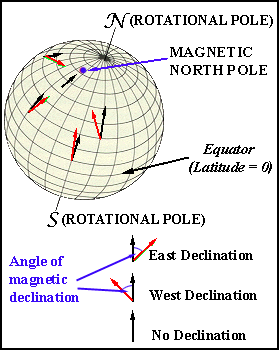
Grid North points to the center of rotation at the North Pole. Your compass is guided by a magnetic field in the molten core of the Earth. The fluid core moves and does not exactly follow the rotation of the surface.
Oct 31, 2017 1:39 AM
#
rm:
If you use GPS with them, then it may be useful to use Universal Transverse Mercator (UTM), as it's in terms of meters, which makes it easier to relate coordinates, or the difference between two coordinates, to the map and terrain. (If the easting increases by a hundred, you've moved a hundred meters east.). In that case, noting that grid north is not exactly true north (but very close), could be worth mentioning, but in practical terms isn't important. So, I just talk about grid/true north versus magnetic north, which is the vastly more significant distinction.
Oct 31, 2017 1:46 AM
#
"Some maps may have a coordinate grid on them, which makes it easier to calculate distances (especially using the metric system). That coordinate grid has it's own north reference, called Grid North. It's usually, but not always, close to True North, but you should check to see if the grid lines are parallel to the map edges or the True North arrow before using them to align your compass."
Or if you really want a single sentence: "If your map has a coordinate grid on it, the lines running up the page point toward Grid North, which is usually close enough to True North that you can use it as such and get out of the woods alive."
Or if you really want a single sentence: "If your map has a coordinate grid on it, the lines running up the page point toward Grid North, which is usually close enough to True North that you can use it as such and get out of the woods alive."
Oct 31, 2017 2:10 AM
#
You know how people wonder whether the stuff they learned in high school will ever get used in real life? I feel that way about grid north. I've been orienteering dozens of times a year since the mid 1980s without ever needing to worry about grid north.
Oct 31, 2017 2:47 AM
#
@jjcote you got my point - that is why I want something short that is almost just an fyi that kids can easily remember should they ever see a reference, but will most likely not run into it again
@danfoster - I'm already thinking how I can make your sentence even shorter :)
@danfoster - I'm already thinking how I can make your sentence even shorter :)
Oct 31, 2017 8:39 AM
#
I was thinking of adopting the 'red to red' that they are using in some parts of the world. That is where a red bar is printed across the north side of the map and the kids and novices are told that the red end of the compass needle points to the red side of the map .
Then I could not find red in the OCAD colour palate.
Then a group showed up with compasses with pink & white needles.
Other than that its a simple idea
But really there is no need to explain that there is a difference between magnetic and true and/or grid north. "Here's a compass needle. Here's a map's meridian lines. They always point along the same line as each other."
The tough part is convincing them to run 'off the needle' after some well-meaning instructor has drilled them with the Silva 1-2-3 method.
Oct 31, 2017 9:13 AM
#
To answer the original question, no. I didn't even realize orienteers were talking about grid north at all. If the kids find themselves in a situation where they reallly need to use grid north then it will probably be in a context where they will learn more about it anyway (e.g., in the military, or in a GIS class). I would argue that, unlike the difference between true and mag north, knowledge of the existence of grid north is not something that will enhance their lives. Use that sentence to talk about how much fun it is to run through mud instead.
Oct 31, 2017 2:03 PM
#
@gordhun you can create your own "red" in the OCAD colour palete. I actually use that red with beginner school ground maps, drawing an arrow towards the main linear landmark they know, like the main big road, and when not sure whether holding the map right, to turn the map so the arrow points to the road. When later introducing the compass, I teach kids that North is nothing else than an invisible Landmark way up North by the North Pole, and the compass points to that landmark, helping us to turn the map to have the North line arrows point there, too
@Cristina The reason why I still try to explain the grid north (or at least felt I had to) is that it is still something shared when people teach kids using regular hiking maps. Some kids have heard about the grid North in scouting, and I have had adult chaperons stating to kids that the compass points to true North! Go figure. Maybe I'll use something like: grid North is important to people who create and interpret maps....
@Cristina The reason why I still try to explain the grid north (or at least felt I had to) is that it is still something shared when people teach kids using regular hiking maps. Some kids have heard about the grid North in scouting, and I have had adult chaperons stating to kids that the compass points to true North! Go figure. Maybe I'll use something like: grid North is important to people who create and interpret maps....
Oct 31, 2017 2:12 PM
#
GuyO:
I had never heard of "grid north" before reading this thread.
To me, there has always been just true north and magnetic north, with the former being the north on all non-orienteering maps. Why aren't true north and grid north the same thing?
To me, there has always been just true north and magnetic north, with the former being the north on all non-orienteering maps. Why aren't true north and grid north the same thing?
Oct 31, 2017 3:12 PM
#
This image should help:
http://instruct.uwo.ca/earth-sci/350y-001/acadimag...
The rectangular grid lines running up and down are aligned to Grid North. The curved lines all point to True North (the North Pole). At the center of the coordinate grid, the two norths are the same. As you move west, grid north points west of true, and as you move east, grid north points east of true. That's why choosing a map projection is a compromise. You try to pick a single projection for your project area (state, local park, etc) that minimizes the distortion caused by projecting a spherical earth onto a flat map.
"how different are they?"
That's what the North arrow diagram tells you on your map. (USGS topo maps, for example)
https://upload.wikimedia.org/wikipedia/en/thumb/b/...
Of course, none of this matters on orienteering maps, because they don't include a coordinate grid, so there IS no Grid North.
Oct 31, 2017 3:52 PM
#
While it's not one sentence, there's a fun 'discussion' here: http://academic.brooklyn.cuny.edu/geology/leveson/...
I like this image:
Edit: and I just realized grid north. Hah, yeah. Meh.
I like this image:
Edit: and I just realized grid north. Hah, yeah. Meh.
Oct 31, 2017 5:37 PM
#
When you use grid north you can't tell "what colour was the bear?".
And you have to make random turns in the middle of nowhere.
http://www.travelandleisure.com/articles/gerco-de-...
And you have to make random turns in the middle of nowhere.
http://www.travelandleisure.com/articles/gerco-de-...
Oct 31, 2017 8:02 PM
#
@GuyO
I sometimes use this site to get the difference:
http://www.ga.gov.au/geodesy/datums/redfearn_geo_t...
I sometimes use this site to get the difference:
http://www.ga.gov.au/geodesy/datums/redfearn_geo_t...
Oct 31, 2017 8:08 PM
#
Dan,
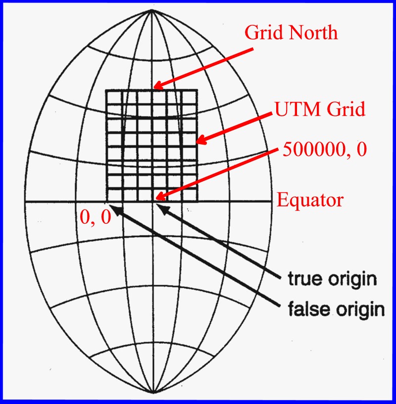
referring to your first diagram, if you shift the UTM grid to the southern hemisphere the relationships between grid and true switch - as you move west true north is west of grid.
referring to your first diagram, if you shift the UTM grid to the southern hemisphere the relationships between grid and true switch - as you move west true north is west of grid.
Oct 31, 2017 9:47 PM
#
I do nearly all of my lidar basemaps in UTM coordinates, so I literally work with grid north all the time.
I might have an image that helps explain it. It's identical to true north along the central meridian (?) of the UTM wedge (Easting 500,000m), and at the equator. Everywhere else it's "slightly" different from true north.
I use a tool to look up the Grid-to-Magnetic angle as an input to Karttapullautin. It's NOAA's WMMGUI program. To get the Grid numbers, you have to input coordinates in UTM. I've complained that they should report it even if you give lat-long inputs.
Nov 1, 2017 8:55 AM
#
There are a lot of fine explanations in here but I'm still wondering why 12-14 year olds need to be taught it during an orienteering outing. This has nothing to do with the sport of orienteering or the experience of having fun running around with a map.
Nov 1, 2017 12:13 PM
#
Finally, thank you.
...but if you still feel the need to ask the question posed in the thread heading, I think we are proving the answer is "no".
...but if you still feel the need to ask the question posed in the thread heading, I think we are proving the answer is "no".
Nov 1, 2017 12:26 PM
#
It is a navigation unit in an outdoor ed class, with 3 sessions at school, and 1 orienteering outing, and a quiz at the end of the session. One main thing I want them to learn is to always pack a paper map, have one in the car, etc., and that map will rarely be an orienteering map, so it is good to know what some things mean on the map they may have, and hopefully learn how to use maps.
Nov 1, 2017 1:06 PM
#
Even though my gut instinct has been to not teach at all about Grid North as I never really encountered it much before running into US maps, it does come up in some sessions where chaperons (always guys...) chime in about grid north, so I wanted a short, elegant answer that is not dismissive.
Thanks to all the great links and explanations in this thread, this is now my
Grid North – Still used mainly by people who create and interpret maps that use an orthogonal flat grid to represent the curved surfaces of the Earth.
It is also funny how many guys talk about hunting in the north woods and always making it back and walking who knows how many miles....way back then..... but are perfectly content on teaching their kids only the use of gadgets, but not what to do when these can't perform for whatever many reasons. But that is an entirely different topic altogether.
Nov 2, 2017 2:47 AM
#
rm:
Hey, if they actually have a map, gadget based or not, that's a big plus from a search and rescue perspective, if they ever get lost. And having a phone with power within cell range will let them go to findmesar.com and tell dispatch exactly where they are, which shortens rescues incredibly. It's amazing how many know how to start a roaring fire (and carry the means), but don't bring a map, GPS, or topo app. But I too digress.
Nov 9, 2017 9:20 PM
#
As @cedarcreek explains, all O base maps should be done in UTM grid, while @Cristina is absolutely correct as well: Since all printed O maps shall have north lines that point towards local magnetic north, there is no deviation to worry about.
This discussion thread is closed.