Discussion: WOC Sprint disqualifications
in: Orienteering; General
Aug 20, 2011 1:48 PM
#
AZ:
There were two groups of disqualifications in the WOC Sprint qualifications. Personally I think both groups were "tricked" by the organizers and that the course planning and mapping was bogus. I see a growing tendency of sprint planners to set these "tricks".
Patrick got dq'ed for cutting across a corner of the park that was mapped with Olive Green. No question he broke the rules. However there are a couple of issues. First the grass was mapped incorrectly. The mapping should reflect what is in the terrain - in this case it was public grass and should have been mapped with yellow. To mark it forbidden to enter, there should have been the purple stripe over-print.
But perhaps even worse, here is what here's what the ISSOM says …
"The course planner should not encourage unfair actions from the competitors, such as crossing barriers or areas with forbidden access. If it is unavoidable to set legs that cross or skirt areas with forbidden access or impassable walls and fences, then they have to be marked in the terrain, and observers should be present at the critical points."
Personally I do not think the WOC 2011 organizers read this part of the rules ;-) Clearly the area should have been marked in the terrain.
How bogus was it? They had carefully planned locations for marshals to stand (in the "forbidden area" - kind of proving that it isn't forbidden!) and the marshals were given clear instructions about how to record violations. Clearly this was a plan to DQ people, rather than an attempt to determine who was the best orienteer.
Aug 20, 2011 1:54 PM
#
AZ:
The second group of DQs was related to the crossing of a wall marked as "uncrossable". All accounts that I've heard give the max height of this wall as 2 feet. So it would not appear to runners to be uncrossable. Therefore, again, the map was wrong. And the course setting bogus.
You can't just arbitrarily mark a wall as uncrossable and then use that to dq runners. You can only map to reflect what the runner will see in the terrain.
This is the issue that was "ignored" by the organizers since it would have resulted in something like 24 dq's. Too bad for Robbie Anderson & others who respected the black line and lost time by running around it.
Come on course planners - we're not interested in this kind of bogus orienteering (doesn't it sound like micro-O). This kind of stuff is designed to slow down the runners by making them run more carefully. The point of sprint is to create high-speed orienteering in which we can see who can make the best decisions while running very very fast. We don't want to be dq'ing people for jumping over small walls or running on grass. In fact we want to encourage this kind of behaviour ;-)
Aug 20, 2011 1:56 PM
#
I disagree. There is plenty of public land that is permanently off-bounds for specific classes of users, such as off-trail runners. This access restriction is consistent with 528.1:
528.1Area with forbidden access (forbidden to cross)
An area with forbidden access such as a private area, a flower bed, a railway
area etc.
528.1Area with forbidden access (forbidden to cross)
An area with forbidden access such as a private area, a flower bed, a railway
area etc.
Aug 20, 2011 1:59 PM
#
AZ:
This was absolutely not forbidden access area. There were hundreds, if not thousands, of people standing in the area. There were no signs anywhere that say "no running allowed". The purple stripes must be used to show areas that have public access but that the organizers do not want runners to enter
Aug 20, 2011 2:17 PM
#
I agree completely with AZ. Why not give every marshal a roll of tape and the instructions to use it instead? It would probably have been about the same amount of work and much less controversy. If you want spectators to stand inside forbidden areas, then put signs that say so.
Aug 20, 2011 2:26 PM
#
The course planner should not encourage unfair actions from the competitors, such as crossing barriers or areas with forbidden access.
Reminds me of a course where many thought it was ok encourage such actions:
COC Long...
Just adding some tangential fuel, no need to burn. ;-)
Reminds me of a course where many thought it was ok encourage such actions:
COC Long...
Just adding some tangential fuel, no need to burn. ;-)
Aug 20, 2011 5:32 PM
#
I don't like the idea of the purple overstripes. It's quite ugly.
I think the olive green works best IF runners are forewarned, it shouldn't be a trick as you say
I think the olive green works best IF runners are forewarned, it shouldn't be a trick as you say
Aug 20, 2011 5:34 PM
#
The South African Orienteering Blog has a great description of the controversial sprint DQ areas complete with map samples and pictures.
Aug 20, 2011 5:48 PM
#
I agree but why we have IOF advisers? They should see potential errors on map and courses which are not matching with the ISSOM rules. Organizers always have so much to think/do in a sprint race. Did they get any instructions before the event when advisers confirmed map and courses!
Aug 20, 2011 5:51 PM
#
I disagree completely.
About map. Map is ok, it's just one of possible corect ways to represent.
Encouraging.... where do you see it? It's not a leg, it's dashed line (marked route ), no options.
About walls. Part of both walls were mapped as uncrossable, part as crossable. No doubt that's correct, look for photos on South Africa team's blog, it's definitely not 2 feets. But there wasn't clear edge between sections, thats why runners were reinstated.
And let's think, why most of initially dsq runners were from second half of ranking page or final protocol or whatever...
Aug 20, 2011 6:17 PM
#
It would be also nice to know the reason of DQ for each runner and the reason why they allowed three runners to run at the end of the FINAL start list.
Just for your information. In MAN A heat STANFEL Matjaz CRO and DIOGO Miguel POR had the same time 17th place but only Miguel was in the Final. It was said that he didn't get information on time about DQ. As he comes from a small CRO team without any team officials at WOC he didn't know what was happening and nobody couldn't help him......
Just for your information. In MAN A heat STANFEL Matjaz CRO and DIOGO Miguel POR had the same time 17th place but only Miguel was in the Final. It was said that he didn't get information on time about DQ. As he comes from a small CRO team without any team officials at WOC he didn't know what was happening and nobody couldn't help him......
Aug 20, 2011 6:27 PM
#
AZ - I haven't noticed a tendency to set such "tricks". Most sprints are (and should be) planned so that DSQ requires recklessness/stupidity on the part of the runner, not mild carelessness.
E.g. in the test race a year before WOC in Norway, there was a lot of olive grass, *all* of it taped.
For the same reason, there is a minimum distance between controls. Planners should not be trying to get as close to minimum as possible to cause mispunches, rather planning the courses to get as few DSQ as possible.
Here it seems like the organisers realised they messed up and had to un-DSQ a whole lot of people. Given how wonderful the rest of the week seemed to be, I wouldn't judge them too harshly. Way worse has happened at WOC.
Aug 20, 2011 8:32 PM
#
To the best of my knowledge, the grass area was crossed between the last control and the finish. This was marked on the map as a taped route. Was the route not taped properly or did competitors ignore the tapes?
Aug 20, 2011 8:46 PM
#
AZ:
No, that wasn't were it happened. It was on the way to the last control - no marked route.
Aug 20, 2011 8:50 PM
#
Aug 20, 2011 8:58 PM
#
AZ:
ndobbs - sorry, I didn't mean to be seen to be harsh on the organizers. I tend to agree that this type of thing should be picked up by the controllers. One objective I have in starting this thread is to bring the issue up for discussion - and to see if I am looking at the world differently than everyone else.
nerimka - I'm not sure how you can say it is okay to map this public lawn as "forbidden area". It is a public place that the organizers don't want runners to cross - therefore they must map it exactly like this, no? as public lawn and use purple - no matter how ugly ;-) The whole point of having a map is to show what is really there on the ground. Imagine some kind of analogy - perhaps there is an area in a forest that the organizers don't want runners to enter. Would it be okay to use olive green? No, of course not - that would be ridiculous. Likewise, the mapper & course planner can't just pull out the olive green because the park grass looks a bit like a private yard. That is my opinion, in any case
nerimka - I'm not sure how you can say it is okay to map this public lawn as "forbidden area". It is a public place that the organizers don't want runners to cross - therefore they must map it exactly like this, no? as public lawn and use purple - no matter how ugly ;-) The whole point of having a map is to show what is really there on the ground. Imagine some kind of analogy - perhaps there is an area in a forest that the organizers don't want runners to enter. Would it be okay to use olive green? No, of course not - that would be ridiculous. Likewise, the mapper & course planner can't just pull out the olive green because the park grass looks a bit like a private yard. That is my opinion, in any case
Aug 20, 2011 9:02 PM
#
Would be nice to see the full protest and reason for reinstatement so we get it right next time.
I see no problem with the map.
I don't like olive green because beginners confuse it with other, accessible, shades, but stripes is usually much worse, forcing the connecting lines to be bent and broken making the map not just ugly, but harder to decipher.
For elite athletes, the final section of map is completely, unambiguously clear: stay on the paths. This is a very common demand of authorities in any race through public parks. And the athletes were even told ahead of time (though there may be some confusion with translation). There's no excuse, the best a team leader might try is "He stepped off the path to avoid colliding with a member of the public".
Elsewhere, a flowerbed with indistinct boundary was (correctly) mapped as lime green. Being indistinct, it should have been taped, but no way would stripey red be any better. Some runners crossed the indistinct boundary, but didn't get DQ'ed presumably because the organisers accepted partial blame.
If the wall goes continuously from uncrossible to crossible with no distinct join,
you can only map it as they did. And again, it's right not to DQ people for being the wrong side of an imaginary point.
(but I do think the control site should be in the middle of the circle)
Luckily, none of the infringements made a big difference to times.
Aug 20, 2011 9:21 PM
#
AZ> I suspect that not organizers, but rather local government doesn't permit runners to cross lawns. But nevermind, ISSOM says that 709 shall be used for LAST MINUTE updates, instead of 528.1
Aug 20, 2011 9:35 PM
#
AZ - mapping forbidden areas in ISSOM as olive green is standard, grass or not. In ISOM it means "settlement" and is not (necessarily) forbidden. 'Fraid you're mistaken on this one.
The principal issue seems to be lack of tape, as it is hard to distinguish (or keep to) the boundary of forbidden areas while running at speed, looking at a map and avoiding squishable French grannies.
The principal issue seems to be lack of tape, as it is hard to distinguish (or keep to) the boundary of forbidden areas while running at speed, looking at a map and avoiding squishable French grannies.
Aug 20, 2011 9:58 PM
#
AZ:
Okay - I think I will have to grudgingly give up on the olive green ;--) But under protest! For example, what if some of the islands of lawn had been forbidden and other not? THen different symbols would be used for the same thing? Olive green for one and yellow for the other. That seems very wrong to me. But I will accept that this is "the norm" and also the good point that the course would be almost unreadable if they'd used diagonal purple.
The key point really is the flagging of the edges, I agree
The key point really is the flagging of the edges, I agree
Aug 20, 2011 10:06 PM
#
What AZ says makes sense to me and I generally agree and am glad he brought it up. There are some other really good points too so I can understand why they mapped the Sprint the way they did and I can accept that too. Still, strictly speaking, I think AZ is correct
Aug 20, 2011 10:41 PM
#
though there may be some confusion with translation
Reminds me of a late 1980s World Cup race where the organizers announced to all of the teams that there would be "many dangerous sheep in the forest."
Reminds me of a late 1980s World Cup race where the organizers announced to all of the teams that there would be "many dangerous sheep in the forest."
Aug 20, 2011 10:46 PM
#
Earlier in the week at the spectator races there were signs warning competitors that the forest was very sleepy.
Also, I think the grass should have been taped.
Also, I think the grass should have been taped.
Aug 20, 2011 10:47 PM
#
We were warned about "domestic animals" in Italy 2005. They were huge! And there were killer sheep on one of the training maps for WOC2010.
Last-minute updates I guess means requiring map over-printing... therefore purple.
Last-minute updates I guess means requiring map over-printing... therefore purple.
Aug 21, 2011 12:03 AM
#
It is a public place
There is no concept of a public place in the ISSOM. "Public place" may be given different interpretations based on the context: country, culture, laws, time of the day. What an Eastern European may take to be a "public place" in North America may be someone's lawn. A lot of the (100% private, without guaranteed right of access) World Rogaine Champs terrain in New Zealand didn't look much different to me than public parks back in the Bay Area, which have private cattle in them.
The map was unambiguous. The organizers didn't want the runners of the path, for whatever reason, and those found off the path should have been disqualified.
Aug 21, 2011 1:11 AM
#
It is entirely possible for something in sports to be exactly according to the rules, and yet be uninteresting and in need of improvement. Like basketball before the shot clock was invented, or soccer when it comes down to penalty kicks. The sprint may have been exactly as the rules specify, but that doesn't necessarily make it good, especially if the athletes and audience don't like it. ISSOM wasn't delivered from heaven on etched crystal plates, it was put together very recently by people like us. Perhaps some adjustments are in order.
Aug 21, 2011 3:54 AM
#
What I don't like about this is the idea that you need to know where you are on the map to know if something is out-of-bounds or forbidden. A 2-foot-high uncrossable wall is mismapped, because it's obviously crossable---Just look at it. You can't expect a runner to check the map for a 2-foot high wall.
Flower beds are pretty obviously questionable, that is, runners should know to check the map. But forbidding grass in a park without tapes on the ground just seems to step over a line. It's something that's uncommon. I've seen "Please stay off the grass signs" in parks, but it's rare. Forbidding public grass without tapes or signs---bogus.
Flower beds are pretty obviously questionable, that is, runners should know to check the map. But forbidding grass in a park without tapes on the ground just seems to step over a line. It's something that's uncommon. I've seen "Please stay off the grass signs" in parks, but it's rare. Forbidding public grass without tapes or signs---bogus.
Aug 21, 2011 7:30 AM
#
Ahh, dangerous sheep and domestic animals? Those are nothing. In California meets, we are used to black bears and wild boar. But nothing compares with my trepidation before a a particular meet, where the course notes read as follows:
The northwestern corner of the park is inhabited by a family of Northern Goshawk (Accipiter gentilis), and it is now nesting season. The Goshawk is a large and beautiful grayish-white hawk, and is widely regarded as one of the most fearless and aggressive of wild animals. If you venture near the edge of its patrolled territory (which I have marked as out-of-bounds on the map), he/she will make him/herself known to you, calling out a shrill "kreee, kreee" and flying from one treetop near you to another. If you persist in approaching his/her nest, you will not see him/her again until he/she whizzes completely silently at low level up from behind you and puts a couple of deep gashes in your head!
I have set the courses so that there is absolutely no need to pass closer than 250 m from the area that I have determined to be the hawk's area of concern. However, the Park folks consider the hawk's area to be somewhat larger (and includes some controls on the advanced courses on Day 2). They are concerned both with your safety and the anxiety of the Goshawks. Therefore, if you should become aware of the hawk's interest in you (see description above), you are required to immediately bail in a direction directly away from the marked area! Failure to do so will result in disqualification. If you come back with a bloody head, you will need medical attention, and be disqualified to boot!
Aug 21, 2011 8:37 AM
#
cedarcreek> after viewing photos of these walls you still claim that they are 2 foot high? I'd say 4 foot would be more realistic. Initial # of dsq among mens was bigger than womens. Why? Mens are statistically taller. Mapping is done not for individual person, but for all. ISSOM says:
"2.3 Barriers that are forbidden to cross
To make sprint orienteering fair to all competitors, features that are represented on the map as impassable, independently of their effective passability, shall not be crossed.
This rule is essential for two reasons:
It is impossible to declare an exact height when an obstacle becomes impassable. Effective passability depends very much on the physical characteristics of the competitors such as body height and strength. If features represented as barriers on the map are declared as forbidden to cross, the conditions are the same for all.
Crossing of certain areas and linear features in parks and urban terrain may be forbidden by law.
Running and navigational skills should be the success factors for competitors in a race, rather than luck when it comes to climbing or jumping barriers or violating public law.
Consequently, competitors who do not obey this rule, which is part of the IOF competition rules, must be disqualified."
Aug 21, 2011 10:24 AM
#
There was a discussion on the World of O live blog at the sprint final, which indicated that some of the successful protests against dsq in the qualifiers were because the runners claimed or were able to prove that they were forced off the paths leading to the last control by bystanders ie spectators, locals going about their business, maybe even the marshalls placed there to watch for transgressions ;-). In a world championships where you are running flat out, and suddenly someone is in your way, of course you are going to swerve around them rather than stop. One day someone will be hurt.
My feeling is that the majority of the elites like sprint races, for many reasons - the speed and the navigational pressure it places on them, and perhaps for the opportunity to perform before an audience.
Earlier this year I set the Australian sprint champs, and we had our own situation with a garden bed. It was a narrow one (1.5-2m) and in the days before the event part of it was dug up, exposing a manhole cover, with the result that it now looked like a place to cross (even though the map did not show that). Sure enough, several people crossed it and may have gained 5-6 seconds (fortunately none of them were elites). No-one was dsq, we (myself, Controller, IOF Advisor - it was a WRE) felt that it was our fault, we knew about it in enough time before the event to have taped it off to make sure no-one crossed.
I agree with AZ that it is organisers who must be responsible and follow IOF rules to make sure that any areas marked as out of bounds on the map that are not clear on the ground MUST be taped. The same goes in this instance for the wall - the impassable part should have been taped.
Those who say the runners are responsible if they do not read the map are simply wrong. Read IOF Rules. Read the Appendix 6 Competition formats, sprint section. eg The course must be planned to avoid tempting competitors to take shortcuts through out of bounds areas. 'Course planning' in this context also means knowing when/where you have to put tapes or have marshalls to make the course work as it should.
Aug 21, 2011 10:43 AM
#
The clear message from the guidelines, which was reinforced at the IOF Event Adviser's workshop I went to a few weeks ago, is that the purpose of out-of-bounds markings is to keep people out of places they're not supposed to be in, not to catch people out. If it's important that people stay out of it and the boundary isn't immediately obvious, then it should be taped.
The guidelines also make it pretty clear that declaring an easily (physically) crossable fence/wall "uncrossable" to create route choice (something that has been done in at least one previous WOC) is not a good idea.
The guidelines also make it pretty clear that declaring an easily (physically) crossable fence/wall "uncrossable" to create route choice (something that has been done in at least one previous WOC) is not a good idea.
Aug 21, 2011 1:17 PM
#
I suppose this is a swing of the pendulum from the opposite end not so long ago, having a mandatory route down from a much higher wall onto an insufficient mattress, resulting in a competitor breaking a bone.
Aug 21, 2011 2:03 PM
#
The way I see it is this: The map represents what's in the terrain, and the terrain dictates whether you go through something or not. There's two reasons to not go through something, because you can't (a building, 6 ft high wall etc.) or because you're not allowed for safety or landowner / private property reasons.
There should be a list of terrain features that we can't cross, not a list of map symbols that we can't cross. This list should include buildings, large walls, high fences, obvious private property, gardens, and maybe a few other items. These symbols should be mapped with the appropriate symbols and crossing them should result in a dsq for safety and fairness rules. Anything that is not on the above list (ie is not obviously uncrossable in the terrain) but needs to be out of bounds / uncrossable for whatever reason should be marked in the terrain as such. Runners should be able to look at the terrain and determine whether they can run through something or not and not have to rely solely on the map. For items like lawn that need to be deemed uncrossable their should be signage saying you can't step on the grass. For a wall where some of it is uncrossable and some of it is not then the point where it changes from crossable to uncrossable should be flagged in an obvious way right on the wall.
To me the terrain should be the deciding factor and not the map. Otherwise you could theoretically do silly things like mapping a maze in open grass using olive green and demand runners to count steps to navigate a maze that isn't actually in the terrain... Now that I've suggested it please don't ever do that ;-)
Aug 21, 2011 2:16 PM
#
But forbidding grass in a park without tapes on the ground just seems to step over a line
But the boundary for the grass was obvious. (I will not argue the semi-passable wall; I am primarily concerned with runners not staying off the grass.) The boundary was the edge between the grass and the pavement. The rule for the obstacle was applied uniformly in that area. There was no temptation to take shortcuts since the area was innervated by paths and staying on each path in each mini-block saved a fraction of a second at most.
My main motivation in this argument is our ability to hold future Sprints in an urban area without much fuss. It we are forced to tape all obstacles, we won't get many permits—groundskeepers don't like "defacement". If runners rigtheously claim their entitlement to cross anything that appears in their way that isn't taped because they are potentially confused, we will lose our permits and won't be allowed in again. I agree that the obstacle's boundary and its nature should be obvious to the runner, and in the case of the grass islands, they were.
The logic of Jeff is great in an ideal world. In an ideal world we'd be welcome to hold an event in any "public place". We rely on the runners' attention to the Rules and on a lot of back-and-forth with park and private-property managers to be able to hold events in areas such as San Francisco's Golden Gate Park and, potentially, Central Park in New York.
For items like lawn that need to be deemed uncrossable their should be signage saying you can't step on the grass.
Try running on a public golf course in the United States and see where that gets you. You can step on the grass (if you have paid the fee). You can't usually run on it without much heckling. There are lots of examples of similar access arrangements.
Aug 21, 2011 2:33 PM
#
Vlad, let me clarify / update my stance:
I'm not suggesting tapping all obstacles - only those which are ambiguous. And with a good mapper and course setter, and reasonable land-owners (not always possible I know) then minimal taping should be required.
As for your golf course example...
Is a golf course not obviously private property? In the case of a golf course I think I would map it in olive green write golf-course over it on the map and mention it in the course notes - All golf course is out of bounds.
The problem is when some lawn is out of bounds and some isn't and two map symbols get used to map the same feature. From looking at the terrain how are we, the runners, to know which grass we can cross and which grass we can't? That's when it should be signed in the terrain.
Aug 21, 2011 2:41 PM
#
Is a golf course not obviously private property?
A lot are public. The one at the college I went to was public. You could run on it with a permit, they held NCAA cross-country races regularly. An orienteering event would have been possible with a permit, to get which it'd have been necessary to convince the athletic department the event was in their interests—hard but not impossible. You would be heckled if you went on the course without a permit or golf clubs.
The problem is when some lawn is out of bounds and some isn't and two map symbols get used to map the same feature. From looking at the terrain how are we, the runners, to know which grass we can cross and which grass we can't?
In the particular case of the WOC Sprint Qualifier, it was all of the grass within that one specific city block, and none of the other grass. I think it's specific enough, and it's hard to see how a runner would be off by multiple city blocks (none of the immediately adjacent blocks were mostly grassy).
Aug 21, 2011 2:45 PM
#
You'd think it specific enough and yet a lot of WOC level runners still crossed it...
Aug 21, 2011 3:57 PM
#
... because they thought it was no big deal, and so had to suffer the consequences.
Aug 21, 2011 5:00 PM
#
I have no idea, but their could be several reasons for why they went on the grass. Certainly there were reasons enough for people to get re-instated into the final very late on in the day.
I do doubt that any WOC runners I know would try and knowingly cheat when they are pretty much in the arena and in full view of hundreds of spectators.
I do doubt that any WOC runners I know would try and knowingly cheat when they are pretty much in the arena and in full view of hundreds of spectators.
Aug 21, 2011 5:47 PM
#
Certainly there were reasons enough for people to get re-instated into the final very late on in the day.
There were two issues; the wall and the grass. On the wall, I agree with those who say there should have been markings in the terrain, since it's not possible to discern from just looking at the wall exactly where the wall becomes passable, and since a route choice went across the wall.
With the grass, almost no time was gained by not staying on the paths—the course didn't force anyone to go through the grass. I don't know whether the reinstatements were related to the first issue or the second one—can anyone say with certainty?
Aug 22, 2011 1:03 AM
#
But Nixon would those runners cheat when not in the arena and out of view of spectators?
Aug 22, 2011 2:00 AM
#
No. There should be a fundamental recognition by everybody involved in orienteering that elite runners in the World Championships do not set out to cheat.
Furthermore, when someone gets disqualified they are entitled to due process; an explanation of what the transgression was and a chance to have their side heard. That is very difficult with only a couple of hours between heat and final. And there should be some sort of public explanation was to why so many were DQ'd and indeed why some were re-instated.
Furthermore, when someone gets disqualified they are entitled to due process; an explanation of what the transgression was and a chance to have their side heard. That is very difficult with only a couple of hours between heat and final. And there should be some sort of public explanation was to why so many were DQ'd and indeed why some were re-instated.
Aug 22, 2011 2:26 AM
#
I know at least one competitor still doesn't have a clue why they were disqualified. Apart from anything else, the potential for mistaken identity in such a situation is not trivial.
Aug 22, 2011 4:01 AM
#
Furthermore, when someone gets disqualified they are entitled to due process; an explanation of what the transgression was and a chance to have their side heard.
I agree. And Scott Fraser et all with hand-scribbled race numbers sure didn't look that good on national television—I don't know Swedish that well to have understood whether the commentators tried to explain what was going on to the audience. It seemed that the organizers were prepared to disqualify runners, but not at all to deal with the consequences. I think if the sport were to be taken seriously, the procedure should be somewhat akin to soccer—the ref's (jury's) word is final as far the rest of the play/game is concerned (but there should be possibilities to review things before this verdict is rendered). If someone who was red-carded were allowed to play pending an appeal, soccer would look just silly. Same here—the jury should have made a final decision before the Final.
I agree. And Scott Fraser et all with hand-scribbled race numbers sure didn't look that good on national television—I don't know Swedish that well to have understood whether the commentators tried to explain what was going on to the audience. It seemed that the organizers were prepared to disqualify runners, but not at all to deal with the consequences. I think if the sport were to be taken seriously, the procedure should be somewhat akin to soccer—the ref's (jury's) word is final as far the rest of the play/game is concerned (but there should be possibilities to review things before this verdict is rendered). If someone who was red-carded were allowed to play pending an appeal, soccer would look just silly. Same here—the jury should have made a final decision before the Final.
Aug 22, 2011 8:00 AM
#
I know a German that stepped on the grass, then backpedaled so that they were off the grass and went around on the path, he was dsqed and yet people who took several steps on the grass (apparently like Khramov) were not. It ended up being up to the organisers to decide who they wanted in the final.
And in the end, the jury made a decision that would not affect the final results. They made sure that it looked like they didn't make a mistake by including some runners in the finals and excluding others.
And in the end, the jury made a decision that would not affect the final results. They made sure that it looked like they didn't make a mistake by including some runners in the finals and excluding others.
Aug 22, 2011 8:45 AM
#
One of the Swedish announcers didn't have a clue what was going on most of the race anyway (in my opinion) but when Scott Fraser appeared the first time I think one of them said 'there is Graham Gristwood' who of course had already finished.
Aug 22, 2011 11:40 AM
#
I like to think of orienteering as the sport of creative shortcuts, where you choose your own route. Urban sprint orienteering sometimes gets pretty far from that. That isn't a problem with the event, by the way, it's a problem with me.
It we are forced to tape all obstacles, we won't get many permits—groundskeepers don't like "defacement".
Think a little more creatively. There are ways to tape off an area that will not result in any sort of negative impact to the area at all. For example, the taped chutes for the Relay at WOC93 were largely across a paved parking lot. The tapes were attached to freestanding stanchions.
Aug 22, 2011 2:15 PM
#
I like to think of orienteering as the sport of creative shortcuts, where you choose your own route. Urban sprint orienteering sometimes gets pretty far from that.
Philosophically, that's the nature of living in a city, isn't it? You have to put up with a large number of other people and obstacles to your fruitful existence that they create. The only path to nonviolent coexistence is compromise via adherence to a set of largely arbitrary, majority agreed-upon rules, which nobody likes but which in the end turns out to be in the best interest of the average (and nobody is the average).
There was a choice in the mid-1990s. The sport could remain in the woods and retain more of the purity, freedom, and independence, or it could embrace the PWT's line of thought. After all, the majority of the world's population live in cities. The key, to me, seemed the elites' buy into PWT... so they after all shouldn't complain that the sport has lost its purity.
Aug 22, 2011 2:54 PM
#
I think that the prohibited areas concept may have been a slippery slope. Initially the Park-O events were in parks, and there were a few limited, well-defined areas that needed to be indicated as Keep-Out. As more events took place, and the events migrated to city streets, more ambiguous obstacles were encountered, and due to a combination of safety, permission, and the ability to use these things to create puzzles, the use of them grew. It's like the vertical green lines on an ISOM map -- originally intended just to indicate that a field is overgrown and slow, it came to be used for small patches of undergrowth in the forest, in some cases rendering maps illegible.
(I also don't like the olive-green color one bit, because I find it pretty difficult to distinguish from yellow. It's okay on an ISOM map because it's usually obvious from context, but for small bits on an ISSOM map, it's awful. I'd much prefer purple. And I am colorblind, so take this with a grain of salt.)
Well, it will be Corn Maze Orienteering season soon. Great sprint terrain, and not much ambiguity as to where you can and cannot go.
Aug 22, 2011 3:31 PM
#
AZ:
I believe that everyone dq'ed for "cheating" at the wall was reinstated. In the park at the end it was a different story. I believe the criteria there was that runners "forced" onto the grass by the public were 'okay' while others weren't. I understand that the appeal process was quite specific - the organizers had planned where the marshals would stand. There was a map with "X" at each marshal position, and the marshals took very precise and specific details regarding how many steps were taken on the grass. I think it was well planned and executed from that aspect. Just the wrong way to go about things ;-)
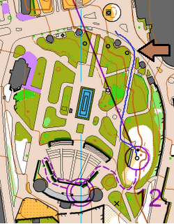
Here for example is what I understand happened for one of the dq runners - just to give you a sense of what actually was the issue. The runner's route choice is shown in blue and the runner was well aware of the rule of not stepping on the grass. The runner was also fighting for a place in the finals, running extremely fast, looking far ahead to see where to run to, and quite tired. One of the key points on the chosen route is the statue (marked with the brown arrow). This was the point at which to turn sharply into the park. To run the corner as quickly as possible obviously the runner must stay close to the statue. But look really closely at the map - there is about 1mm of olive green there between the path and the statue. The runner ran through that bit of olive green without having any idea. Of course not - there were hundreds, if not thousands of spectators in the park many of them close to that point. The important thing for the runner was to look through this field of spectators to find the track to run down and to try to see ahead to the next corner. That is the nature of sprint orienteering.
I can agree that marking all the grass as forbidden made the orienteering a little more interesting at the end of the race, so maybe that was an okay decision. But in this case the runners were clearly tempted to cut that corner closely and it should not have been a surprise that runners did not notice the tiny strip of olive green and stepped on the grass. In fact, I don't think the organizers were at all surprised since they'd planned very carefully to have a marshal there. So clearly (at least in my opinion) at least those corners at which they expected to see runners cutting the corners - those should have been taped.
My basic principle is that if it is important that runners stay out of an area, then it is the responsibility of the *organizers* to make sure they stay out. The runners will be tired and will make mistakes, and to risk not being able to return to a venue because of a mistake made by a runner is too risky for me.
Aug 22, 2011 4:05 PM
#
AZ:
And to give you more of an idea of what the runners were looking at, here is one of my favorite WOC moments. Carol is approaching the last control cleanly when she meets the confused Serbian runner running in the opposite direction. This causes Carol to stop & double check. But you can see it isn't so easy to see the paths and the edges of the grass as you might imagine from looking at the map ;-)
Aug 22, 2011 6:10 PM
#
The hedges at our 2009 event were very obvious both on the map and in the terrain. Yet multiple national-team-level runners ran through/jumped over the hedges, which put out future access to the site in jeopardy. The same almost happened with an uncrossable fence at a later stage. Had I not pointed out that what a pre-runner was doing was not allowed, I'm sure some of the later runners would have climbed over it. Why? The only explanation I can find is that they thought it was no big deal.
I believe it's human nature to take shortcuts. And I also believe if we had to buy a roll of tape long enough to cover all hedges at SFSU, we wouldn't have been able to afford the event because of either money or time it takes to tape everything.
I have to admit that my enthusiasm for putting on urban Sprints is rapidly waning as this discussion goes on.
Aug 22, 2011 6:30 PM
#
One way to set urban sprints which eliminates a lot of these concerns is to just put up a "stay on pavement" rule. No running on dirt or grass. Appropriate for some venues, but not for others, and it obviously requires some thought when setting courses. For Aix-les-Bains, it would have had to be "stay on pavement after entering the city on the way to control #8". Seems like the campus maps I've run on would in general have worked fine with such a rule. Would that have been practical at SFSU, Vlad?
Aug 22, 2011 6:47 PM
#
SFSU had plenty of grass that was good for route choice, and we weren't prohibited from using the grass. But if the rule were to be put in place, I think the courses wouldn't have been affected dramatically. Where this rule would really foul up things is at Stanford and Berkeley, which have woods and also faculty residences, which for all practical purposes look like AZ's notion of a "public" place with unfenced lawns, but aren't public.
Aug 22, 2011 7:06 PM
#
At Polish champs in Wroclaw Zoo a couple of years ago, a number of (not national level elite) runners went straight from the start, and at the first possibly opportunity jumped a wall into olive green, then a ditch and scared the bejaysus out of some zebras.
Elites didn't buy into original-PWT - those races were too easy, technically. Elites bought into sprint when they went really technical, requiring real map-reading speed.
Is this discussion still going? Hammer started a post-WOC-withdrawal thread...
Elites didn't buy into original-PWT - those races were too easy, technically. Elites bought into sprint when they went really technical, requiring real map-reading speed.
Is this discussion still going? Hammer started a post-WOC-withdrawal thread...
Aug 22, 2011 7:53 PM
#
Looking at the map AZ posted, I honestly don't have a problem with the use of yellow-green. It looks reasonably clear to me. But the number of DQs is indicating there is a problem. From what I'm reading (I couldn't watch the coverage), it sounds like the problem is crowd control---They needed barriers and marshalls, not to keep the runners off the grass, but to keep spectators out of the legal pathway.
Aug 22, 2011 10:30 PM
#
cedarcreek is absolutely right. i was running the sprint, and as i was approaching the area the olive was quite obvious on the map. so i just said to myself to stay on the the paths. on the other hand it was indeed difficult to see far ahead, as there were loads of people in the park.
Aug 23, 2011 12:44 AM
#
Some runners in Wroclaw Zoo were lucky! According to author Jared Diamond in Steel, Germs, and Guns, one reason that zebras have never been domesticated is that when they bite, they hang on tight.
Seriously, would "Stay on the Grass" signs, barriers, and marshalls for spectators have been feasible for a sprint ending in a park?
Seriously, would "Stay on the Grass" signs, barriers, and marshalls for spectators have been feasible for a sprint ending in a park?
Aug 23, 2011 2:13 AM
#
It seems like a common theme with the JWOC marked route problem: The course setters wanted this leg to have navigation to achieve maximum spectator excitement. They didn't want to compromise either by barricading the route or by making the grass legal; either probably would have fixed the leg. So they end up with a bad leg and a lot of controversy. The fact that they had marshalls assigned to DQ runners I think proves my point---this should have been seen as a warning sign.
{Edit}: I hate to say, "They should have seen this coming", because it's really hard to predict this sort of thing sometimes. Maybe they thought they'd have adequate marshalling to keep clear paths. But I do fault them for DQing the runners. They knew there was a problem and they did the wrong thing.
{Edit}: I hate to say, "They should have seen this coming", because it's really hard to predict this sort of thing sometimes. Maybe they thought they'd have adequate marshalling to keep clear paths. But I do fault them for DQing the runners. They knew there was a problem and they did the wrong thing.
Aug 23, 2011 12:02 PM
#
This is a really informative thread. Graeme and I had a similar discussion (agreement to disagree) on Nopesport but with much less activity from others.
What is very well illustrated here is that it is equally possible to interpret the ISSOM guidelines on olive green in two different ways. Like AZ I am adamant that publicly accessible grass shouldnt be mapped in olive green like that (based on the guidelines) but Graeme and other presumably equally experienced and knowledgeable competitors think that the guidelines allow for this. SHould then the solution be to firm up the ISSOM guidelines?
I do think that the argument for the way it was done at WOC is undermined signficantly by the number of competitors who were DQ'd. Seems fairly clear that this didnt work. Whether the solution is taping (which might be correct but impractical) or simply avoiding use of that part of the area, i dont know. I'd certainly think harder about it next time.
Aug 23, 2011 2:20 PM
#
or simply avoiding use of that part of the area
As I said, my enthusiasm for putting on urban Sprints is all but gone. If there is a deep-seated feeling of entitlement among the competitors to shortcut no matter what the map may say, then these competitors aren't worth the effort we put into securing access to some of the most spectacular areas on the globe.
As I said, my enthusiasm for putting on urban Sprints is all but gone. If there is a deep-seated feeling of entitlement among the competitors to shortcut no matter what the map may say, then these competitors aren't worth the effort we put into securing access to some of the most spectacular areas on the globe.
Aug 23, 2011 5:03 PM
#
Thats a bit presumptive. Do you really think that many people are prepared to cheat in front of cameras and hundreds of spectators and with GPS tracking in the WOC? Responsibility (thats different to blame) for the problem at WOC sprint lies with the planner and controller in my opinion. Do they not provide a report these days?
Aug 23, 2011 5:33 PM
#
My problem is that I keep seeing excuses in this thread for not following what to me seems a clear set of international Rules. Maybe the runners wanted to cheat (hard to believe); most likely, they just didn't think much about the fact that the mapper/course setter/organizers really didn't want them on that lawn. If that's the prevailing attitude, willingness to cheat or not, then we are up for major problems in high-visibility areas. If I as the course setter/mapper cannot rely on the absolute majority of runners being able to willingly follow my instructions to stay out of certain areas, relayed via agreed-on map symbols, then I don't have an inexpensive, non-disturbing instrument to convey land use restrictions. In this case I cannot guarantee to the land managers that we'll generally comply with their desires, and should not use areas that have any potential to become in this way contentious—which is the majority of spectacular urban parks in the U.S.
Aug 23, 2011 6:24 PM
#
I have to agree with that - we see it time and time again amongst non-elites at British urban/sprint races. I guess they aren't good enough or fast enough to read the map and therefore just cross where and what they can - really surprised it happened so extensively at the World Champs though.
Aug 23, 2011 6:54 PM
#
I don't want to be seen as making excuses for not following rules. I think the issue with the WOC is that runners had a choice of staying on the legal path and risking knocking over little old ladies, or taking a few steps off the path to avoid a collision or a delay.
For any event here in America (short of a WRE, let's say), I don't see your argument. I think people will follow the forbidden area rules with very few exceptions. But what I want to see is agreement between the map and the terrain. If my plan is to run until I see an uncrossable wall, and I get to a 3- or 4-foot wall, I might cross that wall, because I might not realize that is the wall I'm not supposed to cross. And as I said before, I think people are really good about things like flower beds, because they know to check the map. But it's wrong to expect people to check the map for stuff that's normally crossable.
If all the grass in a park is untouchable, then I can stay off it. But if there is some uncrossable grass next to runnable grass and no obvious way to tell which is which, then I have a problem.
Aug 23, 2011 7:02 PM
#
The hedges that we had at our 2009 event were very obvious, and mapped exactly as they were. Hedge, olive green. Grass next to it, yellow. People still jumped.
But it's wrong to expect people to check the map for stuff that's normally crossable.
That's exactly what I have a problem with. How do you define "normally"? What's normal in one jurisdiction/culture is not normal in another. Flower beds may be perfectly fair game when there aren't flowers in them. I am dissatisfied because I see a lack of willingness to take absolute guidance from the map as to what's allowed and what's not, and a desire to augment this guidance with a person's subjectiive-frame-of-reference common sense. I don't think you can have a fair sport with this attitude.
Aug 23, 2011 7:23 PM
#
Vlad, are you referring to the thin olive green strip separating the pavement from the yellow open land at SF State? I think there's a separate AP thread about that from two years ago, (though I can't seem to find it). I think the difference in that case was that some people didn't feel as though the olive green was not distinct enough on the printed maps, so some people didn't see it? Am I remembering this correctly?
Aug 23, 2011 7:33 PM
#
There was no "the strip"—the olive green was used to show distinct (plant-filled) areas to which we didn't have permission to enter. On this particular map it was easy to identify these areas at least in the terrain, since pretty much anything planted was out of bounds as a rule.
Aug 23, 2011 7:50 PM
#
Ok, the only issue I remember coming from that event was leg 9-10 during Sprint #3 at SF State, which involved a strip of olive green that separated that stairway from the grass, that some people didn't notice was on the map.
Aug 23, 2011 8:08 PM
#
Yes for this particular issue I will take the blame, the olive green should have been wider. But what do you think about the area at Sprint 3 Control 2? It seems fairly clear that the passages are embedded in olive green. It is this area that I'm mostly aggravated about. And, the one transgression that I can see from RG tracks at Control 10 that you mention wasn't in the thin-strip area. It was somewhat more obvious.
Aug 23, 2011 9:00 PM
#
I think if the sport were to be taken seriously, the procedure should be somewhat akin to soccer—the ref's (jury's) word is final as far the rest of the play/game is concerned (but there should be possibilities to review things before this verdict is rendered).
Also IOF jury attitude is not very bright example. If we were a media sport they would need to present a final report to general public with all their reasons for DSQ and for reinstatements. But probably we will never see this report. Strange but you can't expect that this kind of sweeping under the carpet have no influenses on runner's future decisions.
But it's wrong to expect people to check the map for stuff that's normally crossable.
That should be the norm for mapper/course setter and organizers! Sport is made for competitors and not for officials. When you are tired you can't think. People make mistakes, get lost and you can't expect from them to check all the map symbols, colours and to connect this with definitions when they plan the route. Just a few of elites can do this. One problem at sprint races is that runners run so fast that they can't see all things on the terrain. It is the same like in the forest. Everybody try to simplify things just to be able to run faster. At sprint events this is at least a few times even more requested ability from a runner aiming to get a good result. Some runners make mistakes because they run faster than they could read the map. You can't judge them as cheaters if they make a mistake. Some of them also don't know the rules very well. We must realized that all forbidden areas or features which are crossable must be taped. When somebody will cross taped area than we could call him/her a cheater with no respect to the organizer, course setter wishes and rules!
I realised this when I was organizer and course setter for our Sprint Champs in 2009. Here is a map of National sprint championship 2009 and the problematic leg was 13-14. Leg crossed the river and river sides were marked with black uncrossable line. Mapper did it right as the river was very fast and dangerous. When I was setting the courses it was the same but on the event day the river was very low and it wasn't dangerous anymore. After the race I got info that some runners crossed it. It was our mistake because we didn't tape it. They were not cheaters in my eyes as I know that they thought that it was just an ordinary stream. It was hard for them to see black line when running at high pace. Runners trust the organizers that they will give them clear massage also on ground when it comes to dangerous or uncrossable features (which might look crossable)! I take this and when I am a competitor I expect the same from organizers to do for me.
Aug 23, 2011 9:12 PM
#
We must realized that all forbidden areas or features which are crossable must be taped.
Great. So as an organizer, I must tape off:
* Every hedge, planter, and flower bed.
* Every building entrance (runners may be so confused that they mistake a door for a legal building pass-through), thereby hindering the regular public's passage.
* Every water feature (example above).
* Every fence, except the ones that are like national borders of repressive countries and southern U.S. States.
* Every wall that a skilled climber can scale.
I'm outta here. No more urban Sprints from me. I'm almost serious.
Aug 23, 2011 9:13 PM
#
No no no
Alerts in course notes/bulletins, if necessary some tape, also mentioned in course notes.
Poor T/D, I'm starting to see your point of view, but please persevere. SF state looked fun.
Alerts in course notes/bulletins, if necessary some tape, also mentioned in course notes.
Poor T/D, I'm starting to see your point of view, but please persevere. SF state looked fun.
Aug 23, 2011 9:23 PM
#
Yes this year's SF Sprints are almost entirely forested, so (hope for) no controversy there, permission to pass everywhere except where taped off, but for 2013 we were thinking a mostly urban setting, and I would need a venture capitalist buy-in to afford this much tape, and a small army to place it all over SFSU/UCSF even if they were to give OK to such atrocious decoration.
Aug 23, 2011 9:28 PM
#
No, you probably pick the wrong terrain for sprint area. Why you insist in first place to organize the sprint in an area with so much problematic features and restrictions.
It is a nightmare. As a good organizer you should know which terrains, areas are good for high level orienteering events and you must be able to take decision by your own judgement which include also your willingness to do extra work for an event. If you are not willing to do than it is better not to do it. You must be able to make a reasonable decision after collecting all the information from landowners, authorities, etc. As we are outdoor sport we can't expect that every area is available for us.
It is a nightmare. As a good organizer you should know which terrains, areas are good for high level orienteering events and you must be able to take decision by your own judgement which include also your willingness to do extra work for an event. If you are not willing to do than it is better not to do it. You must be able to make a reasonable decision after collecting all the information from landowners, authorities, etc. As we are outdoor sport we can't expect that every area is available for us.
Aug 23, 2011 9:31 PM
#
It'd be so much easier to use the tape an entire marked route from start to finish!
Aug 23, 2011 9:40 PM
#
Why you insist in first place to organize the sprint in an area with so much problematic features and restrictions
I don't get raving mad that often anymore, but this did it. Now I am really out of here. I wrote something sensible about compromise and responsibility, but I don't think it has a chance of being understood. Hope your government pays for your privilege to run wherever you want.
I don't get raving mad that often anymore, but this did it. Now I am really out of here. I wrote something sensible about compromise and responsibility, but I don't think it has a chance of being understood. Hope your government pays for your privilege to run wherever you want.
Aug 23, 2011 9:51 PM
#
Could the Organisers have used the Olive areas to corral spectators out of the way using tape or crowd barriers with crossing points etc, thus making the area the same for every athlete from first starter to the last regardless of crowd density? (yes i know not possible for every sprint but it s for WOC)
Is it not inherently unfair to allow a wall of spectators (Connected or not to those athletes!) show later starters exactly where they need to go?
Why cant the organisers can plan where people congregate, like every other major sporting races?
Expecting athletes to work out where the Olive starts and ends when they cant even see 10 mtrs ahead of them because of the wall of spectators in the way just does not make sense. This type of circumstance is unique to sprint, as spectators are not allowed into the area in other formats, therefore unique rules need to be worked out. If not Olive the solid purple should be used.
Sprint should be the most accurate of maps that any Orienteer uses, due to the reduced mapper interpretation required.
Having seen 3 versions of the same map recently, latest using LIDAR, even the best mapper can be way off sometimes.
Aug 23, 2011 10:46 PM
#
It might be worth pointing out that the white "island" inside the sea of olive green looked exactly like the rest of the park. That is to say, if one left the last control heading directly north, there would have been no way to distinguish where one was allowed to go and the border of the "island" where it became out of bounds. I don't necessarily mind that the organizers had this elaborate and contrived finish arena with very arbitrary (to an uniformed athlete) boundaries, but it wasn't crystal clear.
Another contributing factor to the confusion is that, beforehand, the competitors were told that there wouldn't be any mapping in the olive green areas, but in the park area shown in AZ's image you can see plenty of trees, knolls, etc.
I think there is a responsibility as a runner to respect the olive green/uncrossable walls, but I don't think it would have ruined the race to be explicit in the team leader's meeting that this particular park would have "some areas marked out of bounds, and that there will be marshalls on the course to monitor and disqualify any rule breaking." Just knowing what to expect would have prevented the controversies...
in T/D's earlier post he mentioned that he had to use the pre-runner's illegal activity as a warning to the rest of the field... but I would reframe that statement to say that if the field is aware of potential problems, they are better able to follow the rules. Should T/D have to go over each and every rule of Sprint Orienteering at the beginning of every race? surely not. But something out of the ordinary could use the proverbial ounce of prevention to avoid the pounds of cure that had to be slathered on last minute by the WOC organizers.
Aug 23, 2011 11:04 PM
#
So as an organizer, I must tape off...
In our case a few purple X overprints over uncrossable black line would also help. So maybe we could make it without a tape. I think that this could be also a good solution for some of the restriction areas. I don't know why nobody use this approach for uncrossable features which are potentially crossable (flowerbeds, lawns, have seasonal effects on the features,....) and aren't dangerous. It seems that X or X X X are more visual respected by the runners (better info) than just uncrossable map feature or olive green. Could this combination give to runners better quality information and better map outlook as combination with purple stripe over-prints?
I didn't get your point about *Every building entrance". If it is forbidden to enter than I expect that door are closed or guarded. In other cases it is just a normal mistake from a runner and I don't know why should be taped. So how should the other people go in and out of the building during the event?
We have the privilege to have so many great terrains! but in urban areas we have the same problems as everybody else.
Aug 23, 2011 11:36 PM
#
Here is another view of the UCSF[whoops, meant SFSU] map TD references. You can see that I transgressed, inadvertently, as I could not read the very thin strip of olive on this particular map (here, blown up: http://www.flickr.com/photos/18115983@N00/41118347...). [It looks like more than half the people who posted their routes on RG did as I did.]
Also, in the terrain, the very diffuse appearance of the bushes along the strip made the 'garden' rather hard to pick out in the terrain where I crossed at that corner on leg 9-10. In practice, you could stride over the width of the garden quite easily. As an aside, I think there is a legitimate question whether the width of that strip of olive is wider than the .5 mm specified for area symbols in ISSOM, but I'll leave that for others to decide.
For I am hardly one to talk, as I am slow to learn about sprint orienteering. I barely validly completed 1 out of 3 courses at this event http://www.dvoa.org/events/results/html/rslt05/nsh... when I was DQ'd (DQ'd myself) for crossing a 'high stone wall' (ISOM 521) and am still trying to figure out what I did wrong. (I'm being a bit facetious about that--it is a de jure issue vs. a de facto one. I think I am right according to the letter but perhaps not the spirit.)
Aug 23, 2011 11:50 PM
#
Wow, Vlad, I hadn't realized until now that people voluntarily chose to post their blatantly illegal SF State routes on Route Gadget! (I'm talking about the issue at control 2). Looks like a reasonably active Attackpoint and BAOC member is one of the major culprits :-)
If people have no problems confessing to these rules violations, perhaps the main issue is one of education. The olive green symbol hasn't been around for that long, and we probably need to do a much better job impressing on both newcomers and long-time orienteers how important it is to not cross these areas. I think a lot of people, when it comes right down to it, still have a "so what" attitude towards olive green, and will cross it if (1) Not doing so will cost them major time, and (2) They are reasonably certain they won't be caught.
100% agree with Vlad on all his other points.
Aug 24, 2011 12:08 AM
#
Whew! I'm safe at #2. I didn't recall an issue there for me, but I just double-checked my GPS route.
Aug 24, 2011 12:12 AM
#
question whether the width of that strip of olive is wider than the .5 mm specified for area symbols
0.16 mm wide Stage 3, Control 2; 0.31 mm wide Stage 3, Control 10. The ISSOM minimum is 0.5 mm² for an area feature. No minimum linear width is given in ISSOM for 528.1 olive green, but it does give a 0.25 mm minimum for green lines and 0.40 mm for 421 green. When I proofed the courses before printing, I also added a 0.70 mm purple line in both areas, which didn't make it into the final output because the olive-green was deemed clear enough on both the map and in the terrain, and because we didn't have authorization to put out the corresponding tape. The competitors had been warned—perhaps not sternly enough.
0.16 mm wide Stage 3, Control 2; 0.31 mm wide Stage 3, Control 10. The ISSOM minimum is 0.5 mm² for an area feature. No minimum linear width is given in ISSOM for 528.1 olive green, but it does give a 0.25 mm minimum for green lines and 0.40 mm for 421 green. When I proofed the courses before printing, I also added a 0.70 mm purple line in both areas, which didn't make it into the final output because the olive-green was deemed clear enough on both the map and in the terrain, and because we didn't have authorization to put out the corresponding tape. The competitors had been warned—perhaps not sternly enough.
Aug 24, 2011 12:23 AM
#
I think the olive green is significantly more clear on the screen (such as when the map was drawn and courses laid out) than on the printed map. In many cases, once maps are printed, if there is something less than optimal, it may be too late to redress.
But, in any case--I knew about the olive green proscription prior to participating in any of those races, and I expect (but can't remember now) that I read those notes affirming my apprehension. I do think that I did not recognize the strip of green at the time as being different than the yellow.
As for the area/line issue... I would have thought that olive green would be understood as an area symbol rather than a linear one in ISSOM, but I must confess I haven't studied the language/exposition closely enough to determine whether that is implied or explicit. It could well be a deficiency in the standards if such ambiguity remains.
Aug 24, 2011 12:24 AM
#
Speaking of the need for better education, take a look at the one posted route on the Yellow course at this event, from the start triangle to control #1. The culprit was a pre-teenage girl, who almost certainly was not aware of the rules. Especially as this happened right at the start, our club was clearly at fault here, for not emphasizing that you cannot run through buildings, unless there is a passthrough marked in grey.
(The building in question is the Stanford Student Union, busy even on a weekend morning, and with glass windows and doors. You can clearly see all the way through from one side of the building to the terrain on the other side. Obviously the best route choice on this leg is to go through the building, if you don't know any better!)
(The building in question is the Stanford Student Union, busy even on a weekend morning, and with glass windows and doors. You can clearly see all the way through from one side of the building to the terrain on the other side. Obviously the best route choice on this leg is to go through the building, if you don't know any better!)
Aug 24, 2011 12:30 AM
#
I offended on Leg #9-10 (although, my feet never touched the ground). I was in serious oxygen debt, struggling to keep up with Will Critcley. I didn't notice the trap until I was about 3 strides away. Even then, I wasn't 100% sure that the brown contour didn't represent a break.
I was also trapped leaving control 2, but figured it out, and went back around. The off-limits nature was clear when you were standing there. But the map encouraged trapping. I think that area was just too complicated to map, even at 1:4000.
A driving concept behind ISSOM, is to make sure all barriers are distinct and easy to read. Since legibility of green is much lower than legibility of black. I'd suggest that if you want a stripe of green to be distinct enough to effect route choice, then that the stripe should be at least twice as thick as an impassible wall (so 0.8mm).
Aug 24, 2011 12:49 AM
#
Can we please stop using the four-letter t-word in relation to sprints? Please?
Aug 24, 2011 1:01 AM
#
The ISSOM specification (3.3) refers to a minimum area of 0.5mm squared, not a minimum width of 0.5mm. T/D's garden areas are perfectly legitimate at 0.16mm wide, because the total area is more than 0.5mm squared.
My preference is to add a distinct cultivation boundary line around olive green for garden beds, particularly next to yellow, as was done at WOC 2010 (see area near control 20). If the garden is in a paved area, there should be a kerb line around it. See my map for this year's Australian Champs. The garden referred to in my earlier post is next to control 21 on course 1.
My preference is to add a distinct cultivation boundary line around olive green for garden beds, particularly next to yellow, as was done at WOC 2010 (see area near control 20). If the garden is in a paved area, there should be a kerb line around it. See my map for this year's Australian Champs. The garden referred to in my earlier post is next to control 21 on course 1.
Aug 24, 2011 1:18 AM
#
0.16 mm wide Stage 3, Control 2; 0.31 mm wide Stage 3, Control 10
Whoops my bad (Lyme fog?) We printed at 1:4000, so they were wider. 0.20 mm and 0.39 mm.
simmo, yes in the first case there was a distinct cultivation boundary because the boundary of the hedge was also the boundary of the pavement. In the second case there was no level change so we didn't feel a black line was necessary.
I would have thought that olive green would be understood as an area symbol rather than a linear one in ISSOM
It is an area symbol, and subject to the 0.5 mm² minimum. The regular forest greens and the 421 green are also subject to a minimum line width of 0.25 mm/0.40 mm for "linear thickets".
Aug 24, 2011 1:26 AM
#
T/D I don't think you need much tape. Where it may be needed is if there is ambiguity, eg a gap in the hedge. If the landowners say ok, go through there, then you show the gap on your map. If they say, no I don't want people going through the gap, we are trying to encourage regrowth, then you tape it off. If people go through the hedge, then I think we need a stronger sanction than DSQ to demonstrate our faith to the landowners. Perhaps a fine, or disbar them from the next major event.
The WOC organisers in France made it difficult for themselves by creating more ambiguities than needed to be there.
The WOC organisers in France made it difficult for themselves by creating more ambiguities than needed to be there.
Aug 24, 2011 1:39 AM
#
Since ISSOM enforces a 0.4mm minimum thickness for 421, I would consider the lack of a similar requirement for olive-green to be an oversight. And I would argue that if the olive green is navigationally important, than even 0.4mm is not good enough, due to it's lower contrast compared with other impassible features.
As for the T-word? Do you mean trap? I'll stop using that word when course setters stop setting them :-)
As for the T-word? Do you mean trap? I'll stop using that word when course setters stop setting them :-)
Aug 24, 2011 8:34 AM
#
Foot orienteering rules
"1.1 The profile
The Sprint profile is high speed. It tests the athletes’ ability to read and translate the map in complex environments, and to plan and carry out route choices running at high speed. The course must be planned so that the element of speed is maintained throughout the race. The course may require climbing but steepness forcing the competitors to walk should be avoided. Finding the controls should not be the challenge; rather the ability to choose and complete the best route to them. For example, the most obvious way out from a control should not necessarily be the most favourable one The course should be set to require the athletes’ full concentration throughout the race. An environment that cannot provide this challenge is not appropriate for the Sprint."
Ability to choose and complete route, full concentration, isn't this an answer?
Aug 24, 2011 10:20 AM
#
But Nerimka you also need to read carefully the paragraphs 1.2 and 1.3 which make clear the parameters for the map and courses should be suitable for interpretation at 'high speed'. You cannot just make a map and set a course for a complex terrain and put all of the onus on the competitors to correctly interpret every little detail at high speed. If the map or course has areas that may be misinterpreted by competitors, you don't just put someone there to disqualify them, you try to avoid this possibility by 1) making the map more clear, 2) taping or directing the competitors, or 3) not including the area on the course.
Aug 24, 2011 11:06 AM
#
I have to agree with blegg here. I think it is inviting problems if ISSOM defines the minimum dimensions of a hard to differentiate symbol like the olive green soleley with respect to area. It is not hard to imagine stylized examples (and I think the SFSU strip is close to this) where an attenuated area satisfies the .5mm^2 criterion but fails miserably with respect to legibility. Again, this legibility problem is compounded by non-offset printing mechanisms.
Aug 24, 2011 4:28 PM
#
Simmo - finally a bit of reason on this debate! Phew. I like your 1-2-3. Very pragmatic.
Aug 31, 2011 1:01 PM
#
What is it with Europeans and 'Keep off the Grass' ? They live on the greenest continent, yet walking on any grass seems to be frowned upon like goosestepping. Sprint O should be like Parkour - get there as fast as you can by whatever route you fancy. Orienteers compete at their own risk anyway.
Aug 31, 2011 3:52 PM
#
What is it with Europeans and 'Keep off the Grass' ?
ever tried to convince a French person visiting the US to actually step out of the perimeter of the gravel or paved path in Central Park (NYC) and actually walk on the lawn ? it takes alot of convincing that it is OK. It's sort of institutionalized in their mindsets.
More than a decade ago, a novel attempt was made in Paris of removing the "don't walk on the grass" signs. Here are the press bits:
---
The green grass beckons in Paris
The Boston Globe
February 7, 1997
PARIS -- For park lovers long accustomed to being shooed away by police in Paris, the day of lawn liberation is at hand. Starting this spring, workers will remove the "Pelouse interdite" signs that bid park-goers citywide to keep off the grass, freeing them …
---
Parkgoers have a new reason to love Paris in the springtime: They don't have to keep off the grass.
This spring, workers will remove the "Pelouse interdite" signs that warn people off the grass, freeing them to walk and relax on 7,410 acres of public greenery."I think it's a fantastic idea. It's much nicer to sit on the grass than on a bench," said Elin Naper Hauge, who goes running in the posh Parc Monceau.
"I couldn't believe my eyes the first time I saw some guards chase some little boys off the grass," she said. "They had just gone to get their soccer ball."
The measure, decided by Mayor Jean Tiberi, does not affect the Luxembourg gardens and the Tuileries, which are run by the national government.
Aug 31, 2011 4:46 PM
#
pi:
But this was not the case in this park in Aix-les-Bains. There was people on the grass in this park all week long and in the qualifier sprint there were literally hundreds of spectators on the grass.
Aug 31, 2011 7:13 PM
#
So the grassy areas that were out-of-bounds were that way simply to force the runners to take a certain route? I think that's intentionally deceptive.
Aug 31, 2011 7:22 PM
#
I haven't heard an explanation from the organizers for why the grass there was marked olive green. Have you? Has anyone else? Doesn't seem right to assume they were trying to trick people, especially since they did try to warn the team leaders about untaped olive green.
My guess, from having stood in the arena, is that they wanted to keep spectators and runners separate. If that's the case, then I think they should have just taped it.
My guess, from having stood in the arena, is that they wanted to keep spectators and runners separate. If that's the case, then I think they should have just taped it.
Aug 31, 2011 7:51 PM
#
Fabi:
I read almost all this interesting debate (I'm one of the three reinstated runner).
Organizers told me that was city major who declare forbidden the grass area near finish line on qualification course. They wanted to preserve or protect this area but organisers didn't think probably that there would have a lot of spectators standing, walking on that grass area too.
It's a typical way of organizing sprint in France I presume as I was dsq in French sprint champs last October (I had a second fastest time) for jumping a wall. This wall was black and grey and marshals said I crossed this wall 30cm too much to the right (running full speed and trying to read the tricky map) from the grey part. Same mistake than WOC...
Here I was first dsq to have cut the grass (border). I didn't realize it as there were so many people on the path. My opinion and my federation too as they did a protest for my case is :
"The course planner should not encourage unfair actions from the competitors, such as crossing barriers or areas with forbidden access. If it is unavoidable to set legs that cross or skirt areas with forbidden access or impassable walls and fences, then they have to be marked in the terrain, and observers should be present at the critical points."
It was really not my week over there... then 3 hours of protest (no food, no rest, a lot of stress, loss of energy) and explain honestly my point of view with organizers and the jury to know 35min before that I could start anyway. Thanks to them they took a decision in my way after studying each cases separately.
Aug 31, 2011 8:01 PM
#
Thanks for sharing. Sounds like the organizers didn't exactly succeed in predicting the behavior of the spectators...
Aug 31, 2011 8:06 PM
#
Eh Fabi, you have a history in France... are you not going to tell about the wall you jumped in Boulogne-sur-mer a few years back too?
I guess you couldn't complain about that DSQ - it was only 6 metres...
I guess you couldn't complain about that DSQ - it was only 6 metres...
Aug 31, 2011 8:27 PM
#
Fabi:
@Neil : In Boulogne-sur-Mer it was more or less a "fun" race not a goal or a championship event
But more seriously in WOC Sprint Qual, there were some good runners who haven't been dsq by crossing this grass area. I won't give any names (it's not the goal) but it was very strange to me...
Also some of my club mates were standing near the black&grey wall and the marshal notice to them that they have not time (too many runners) to dsq all runners who were jumping the impassable wall. Some lost their number bibs in previous forest part, some arrived among others and marshal having no time to take both number. Same case in the park in the end.
What it's clear to me is that some really experienced coachs (from CZE eg.) took really our point of view very seriously and protest with us even they haven't their own runners dsq. It's was a really large support I'll never forget this sportship, fairness support from them.
Aug 31, 2011 8:57 PM
#
C'était pas une Nationale ? I guess that's what happens when you follow tam-tam over a cliff instead of reading the bit of paper in your hand ;p
Oct 19, 2011 4:19 AM
#
AZ:
I just got the IOF's EA Newsletter for October in which there is a bit about the WOC Sprint Qualification dsq issues. It didn't have as much detail as I'd have like to see ;-) (i.e. no inside scoop on the jury deliberations). But it did contain this heartening section:
'A lesson to be learnt from this is that if the organiser recognises that there is a chance that an out-of-bounds area might be crossed by runners, maximum effort should be put into trying to prevent them doing so – this is far better than concentrating on catching offenders and disqualifying them. If a feature or an area does not look obviously “out-of-bounds” on the ground, then tape is required.'
'A lesson to be learnt from this is that if the organiser recognises that there is a chance that an out-of-bounds area might be crossed by runners, maximum effort should be put into trying to prevent them doing so – this is far better than concentrating on catching offenders and disqualifying them. If a feature or an area does not look obviously “out-of-bounds” on the ground, then tape is required.'
Oct 19, 2011 5:16 AM
#
Who even knows how the jury process works? Despite going through it and getting re-instated, and seeing my result on the reprinted official results, the organizers haven't updated the official results on their website and ignored my request for them to do so.
Oct 19, 2011 7:08 AM
#
Here is a headcam video from the sprint qual - so you can see more what it was like:
http://tv.worldofo.com/index.php?id=679
Run just minutes ahead of the official start.
http://tv.worldofo.com/index.php?id=679
Run just minutes ahead of the official start.
This discussion thread is closed.