Discussion: If the DCR can delete trail...
in: iansmith; iansmith > 2013-11-24
Nov 25, 2013 2:48 AM
#
If the DCR can delete trails without telling anyone, you can delete forest, right? Can you hit the rootstock at 16 (or maybe all the unmapped ones too) while you're at it?
Nov 25, 2013 3:34 AM
#
There are a number of places on the map that would benefit from unambiguous point features (e.g. the region near 5). One possible course of action is for us to build large cairns; the stones are so abundant that construction wouldn't require moving them very far. The best thing about a cairn (especially compared with a 0.7m boulder) is that it is exceptionally well defined.
Nov 25, 2013 5:33 PM
#
I probably should not even attempt to defend my control locations, the criticism is sufficient at times to make ME angry, and wonder why I subject myself to the complaining. I will point out to you and others, that in all the cases I have read so far, no one had a solid attackpoint going into the controls which they missed.
You did use the end of the wall at 15, which I had used also, not sure why you had trouble, but the end of the wall is ambiguous, it sorts of dies away gradually and it hard for me to say where it ends.
As for deleting the rootstock, that leaves absolutely no features in that area. I think the rootstocks are very obvious, and can be spotted from at least 50 meters away.
I did not note any unmapped ones in the area, let me know otherwise.
I am sorry I missed the fact DCR had covered the ends of the trail, I only saw their sign on Saturday as I was putting out the controls. I had come into that area from the east previously, and the "closed" trail was very prominent.
I would point out that there are a pair of very prominent boulders on the stone wall about 75-100 meters south of the control. It is how a verified the position of the mapped boulder. I added a boulder to the SE which had not been on the map as although it is probably below the mapping standard (basically 1 m in the Blue Hills) it is fairly large in diameter.
Nov 26, 2013 8:10 PM
#
I suppose I should have clarified: you were not the object of my criticism. My ire at both 5 and 15 was due to my incompetence, especially at 15, where I couldn't seem to go 100m without error. I know as well as anyone how challenging BHE and BHW can be for course setting, and the onus is on the entirety of the club - not any one person - to remedy and cope with that.
I attacked 5 from the big trail/stone wall junction, and while my reliance on my compass has been a source of error for me, I hit the small trail without seeing anything and had to double back. The bigger problem wasn't the placement - as I certainly don't know if it was right - but that the feature was exceptionally vague given the map. I heard a few chuckles about the "trail approx." label in the vicinity of 5, which is clearly not ISOM.
There have been a number of locations in BHW (and on other maps) where I picked what looked like a unique point feature only to discover that it was ambiguous in the terrain. I think 5 would qualify. My semi-facetious remark that we should build a cairn would rectify that by defining an obvious feature. I didn't have any problems with 16, so I devoted very little thought to it. Dunno. I didn't like the placement of control 3; I have thought about using that area for a Traverse control, but I found it too poorly mapped to trust. BHW (and definitely BHE) is not Pawtuckaway, and we have to adjust as best we can. I would love to remap both from scratch, but they are sufficiently low priority and adequate that this is unlikely.
I certainly don't blame you for DCR's modification of the trail south of 5; stuff happens, and the timing can be very inconvenient. It would have been nice to know before the race started that the map was inaccurate there, but c'est la vie. I decided over the top was the best route choice, but even with the trail intact, going right may have been better.
Nov 26, 2013 11:17 PM
#
When I saw the control location for 15, I was at first disheartened, since I had hoped prior to the race that we would avoid this Known Troublesome Area, but was later relieved that the approach was from below. I know I've had problems reaching controls near 15 when approaching from the SE-NW trail to the SW of the area, then contouring. Also have failed at coming down off the little trail junction south of 15.
I think there's just a lot more happening on the ground than is shown on the map, so I knew in advance I had to go slowly there.
I think there's just a lot more happening on the ground than is shown on the map, so I knew in advance I had to go slowly there.
Nov 27, 2013 1:13 AM
#
I have failed in the area approaching from all directions. This time I passed within 10 meters on my initial attack, and lost 9 minutes and three places before I found it. I can't blame it all on the fact that the area isn't mapped very well, but it was a factor. For sure, the open area above the control is not the most distinctive one along that ledge, even though it's mapped that way.
Nov 27, 2013 2:22 AM
#
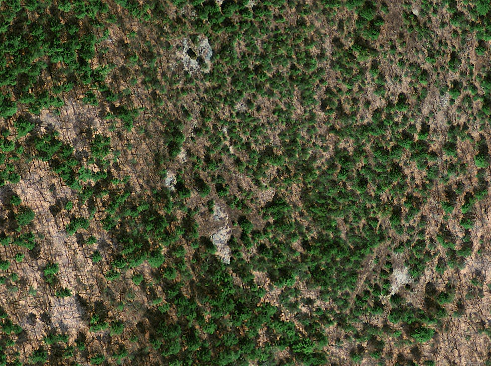
The major problem around 15, is the vegetation. When I do mapping corrections, which I did this year around 3, 5 and 15, the vegetation does not get much of my attention. The main reason for that is it is most time consuming, and once you start you will find yourself traversing large areas of the map, it is never ending.
I made the clear area at 15 smaller, and adjusted the end of stone wall, but there is some diffuse pine saplings around the control, which hide it.
The same problem in the 5 area, scattered areas of green, and a few other boulders which are obvious, but very low.
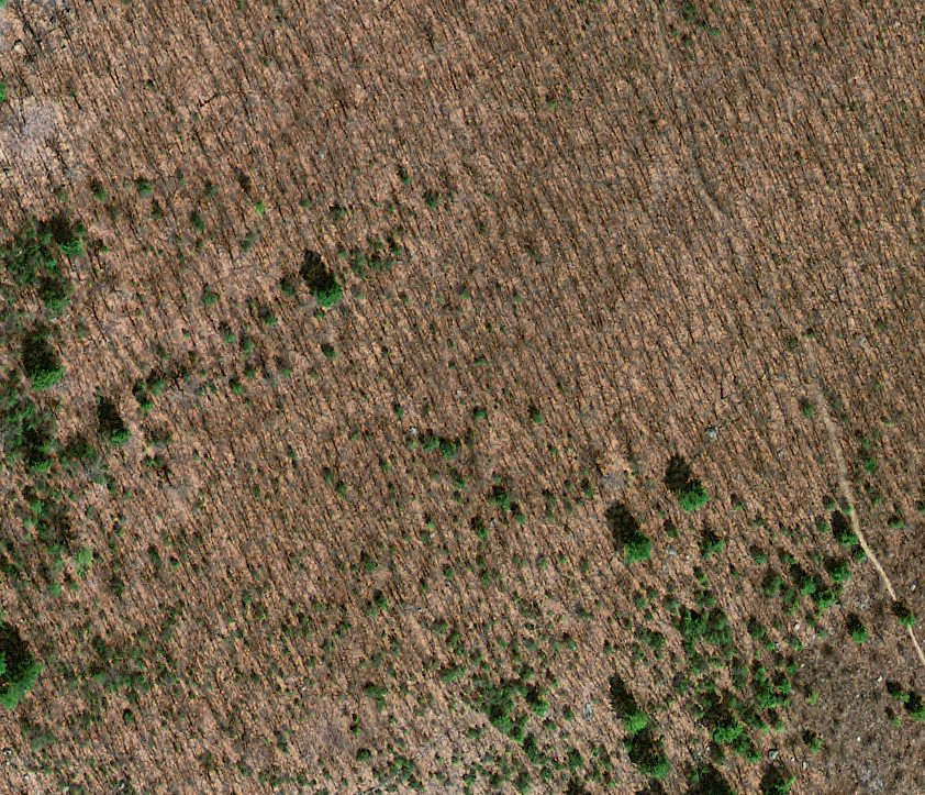
I wonder if there is a winter aerial of the Blue Hills which would allow one to add the pine quickly.
I made the clear area at 15 smaller, and adjusted the end of stone wall, but there is some diffuse pine saplings around the control, which hide it.
The same problem in the 5 area, scattered areas of green, and a few other boulders which are obvious, but very low.
I wonder if there is a winter aerial of the Blue Hills which would allow one to add the pine quickly.
Nov 27, 2013 3:10 AM
#
walk:
You can get a winter aerial c/o GC which even has snow on the ski slope.
Nov 27, 2013 5:12 AM
#
PG:
I guess I would ask about the process for setting controls.
Is the course designed on paper, and then you go out and place the controls, and maybe make a fix or two on the map? And that's pretty much it, because maybe the event is the next day and time is short? If so, that is just asking for trouble.
As opposed to designing it on paper, and then going out with plenty of time before the event, and if a control site or area looks bogus, then going off and finding something good? And having plenty of time to do this?
I always felt that if I wasn't rejecting at least a quarter of my initial control sites then I wasn't doing the job right. More important, I was just asking for trouble (i.e. complaints). Rejecting control sites that were vague, or in areas of poor visibility, or hard to define properly with clues, or the map was especially poor, or that simply just didn't look right.
I never regretted choosing points that were more distinct, more obvious, yes, it's another way of saying easier. But I don't think that is the current practice?
Nov 27, 2013 5:15 AM
#
PG:
If the problem around 5 is there are a bunch of boulders all about the same, and the terrain is sort of vague and sort of thick, then don't use a boulder in there. Even if it may be the correct one.
And if the vegetation is all screwy around 15, then fix it. And assuming there is neither the time nor the inclination to do that, then just find some other part of the map to use.
Or am I missing something?
And if the vegetation is all screwy around 15, then fix it. And assuming there is neither the time nor the inclination to do that, then just find some other part of the map to use.
Or am I missing something?
This discussion thread is closed.