Training Log Archive: dbakkerIn the 1 days ending Aug 30, 2017:
| |||||||||||||||||||||||||||||||||||||||||||||||||||||
| « | » |
| » now | ||||
| We |
Wednesday Aug 30, 2017 #
Note
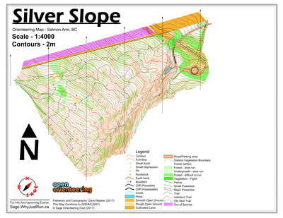
Silver Slope map finished. Named for the two Silver Mines further up the hill (not on the map, but could eventually be on a map expansion - but unlikely), and the fact that the entire map (except for maybe 1 single contour and about 3 formlines) is entirely one hillside. Map details over here. This was something of a speed map, about 3 hours tracing contours, roads, powerlines, etc. and then 6 hours of fieldwork. I think it would be a good idea to use this map instead of Park Hill or South Canoe for the fall series since those maps were already used this spring. Or maybe even swap out Coyote Park or Bastion/Sullivan to give those maps a rest for an entire year.
Map Image:
Map Image:
3 AM
Mapping 6:02:05 10.41 km (34:46 / km) +758m 25:29 / km
Mapping below the Silver Mine on Mount Ida. One of the nicest forests in Salmon Arm, about 60% legitimately white forest, 35% light green slash or light green, and only around 5% darker greens. Unfortunately, the map is steep, and relatively bland and featureless. When I finish up the drafting, borders, and what not I'll post the map tonight.