Training Log Archive: TheInvisibleLogIn the 30 days ending Nov 30, 2020:
| ||||||||||||||||||||||||||||||||||||||||||||||||||||||||||||||||||||||||||||||||||||||||||||
| « | » |
| » now | ||||||||||||||||||||||||||||||||||||||||||||||||||||||
| Su | Mo | Tu | We | Th | Fr | Sa | Su | Mo | Tu | We | Th | Fr | Sa | Su | Mo | Tu | We | Th | Fr | Sa | Su | Mo | Tu | We | Th | Fr | Sa | Su | Mo | ||||||||||||||||||||||||||||
Monday Nov 30, 2020 #
Running 49:48 [3] 7.31 km (6:49 / km) +60m 6:33 / km
shoes: Speedcross 7th pair
Sunday Nov 29, 2020 #
Running 54:49 [3] 8.07 km (6:48 / km) +95m 6:25 / km
shoes: Speedcross 7th pair
Saturday Nov 28, 2020 #
Running 35:11 [3] 5.0 km (7:02 / km) +60m 6:38 / km
shoes: Speedcross 7th pair
Friday Nov 27, 2020 #
Walking 2:30:00 [1] 10.0 km (15:00 / km)
Thursday Nov 26, 2020 #
Running 31:37 [3] 5.09 km (6:13 / km) +40m 5:59 / km
shoes: Speedcross 7th pair
Wednesday Nov 25, 2020 #
Running 46:08 [3] 7.23 km (6:23 / km) +50m 6:10 / km
shoes: Speedcross 7th pair
Tuesday Nov 24, 2020 #
Walking 2:00:00 [1] 8.0 km (15:00 / km)
Monday Nov 23, 2020 #
Walking 3:00:00 [1] 12.5 km (14:24 / km) +50m 14:07 / km
shoes: Speedcross 7th pair
Saturday Nov 21, 2020 #
Running 50:09 [3] 7.15 km (7:01 / km) +65m 6:43 / km
shoes: Speedcross 7th pair
Friday Nov 20, 2020 #
Walking 2:30:00 [1] 10.0 km (15:00 / km)
Thursday Nov 19, 2020 #
Running 25:00 [3] 4.2 km (5:57 / km) +65m 5:31 / km
shoes: Speedcross 7th pair
Tuesday Nov 17, 2020 #
Walking 2:30:00 [1] 10.0 km (15:00 / km)
Sunday Nov 15, 2020 #
Walking 4:15:00 [2] 16.0 km (15:56 / km) +200m 15:00 / km
12.5 kilo pack at finish less food and water. Carried one kilogram excess food.
Saturday Nov 14, 2020 #
Walking 4:30:00 [2] 13.0 km (20:46 / km) +400m 18:00 / km
Friday Nov 13, 2020 #
Walking 4:30:00 [2] 14.0 km (19:17 / km) +450m 16:37 / km
Thursday Nov 12, 2020 #
Walking 4:00:00 [2] 14.0 km (17:09 / km) +450m 14:46 / km
Wednesday Nov 11, 2020 #
Walking 5:30:00 [3] 21.0 km (15:43 / km) +400m 14:21 / km
Tuesday Nov 10, 2020 #
Walking 5:45:00 [2] 22.0 km (15:41 / km) +600m 13:48 / km
18 kilo pack with 2.5 litres of water.
Monday Nov 9, 2020 #
Running 33:36 [3] 4.54 km (7:24 / km) +50m 7:01 / km
shoes: Speedcross 7th pair
Sunday Nov 8, 2020 #
Running 48:38 [3] 7.0 km (6:57 / km) +50m 6:42 / km
shoes: Speedcross 7th pair
Saturday Nov 7, 2020 #
Walking 3:45:00 [1] 11.0 km (20:27 / km)
Friday Nov 6, 2020 #
Walking 2:30:00 [1] 10.0 km (15:00 / km)
Thursday Nov 5, 2020 #
Walking 3:45:00 [1] 15.0 km (15:00 / km)
Wednesday Nov 4, 2020 #
Running 42:42 [3] 5.88 km (7:16 / km) +60m 6:55 / km
shoes: Speedcross 7th pair
Tuesday Nov 3, 2020 #
Walking 2:00:00 [1] 8.0 km (15:00 / km)
Monday Nov 2, 2020 #
Stationary Bike warm up/down 25:00 [2]
Resistance training 25:00 [4]
Sunday Nov 1, 2020 #
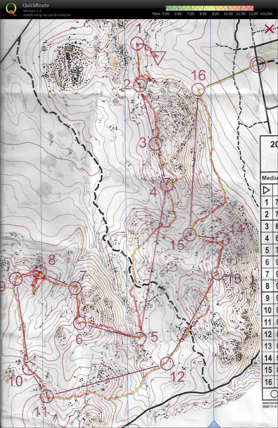
Real Orienteering race (Barambogie North) 1:50:38 [3] *** 8.19 km (13:31 / km) +320m 11:18 / km
spiked:14/16c shoes: Speedcross 7th pair
Control 2 error - making a few assumptions about seeing the top of the ridge. It was false summit. Worked it out but lost six minutes.
Control 4 error - just a little off, a couple of minutes.
Control 8 error - maybe ten minutes. Walked past the control twice within metres (actually within a metre) and didn't see it. It had fallen into a cleft between rocks. And I wouldn't map a bare rock that small either. Totally lost confidence and went in a random hunt at that stage. Julie (who I had caught the previous control) spotted it and that saved me. There were multiple others wandering so I pulled the stick with the flag out of the cleft and put it on top of the "bare rock".
After that Julie and I sort of shadowed each other, navigating independently and losing sight of the other, but generally arriving at controls at the same time. I think she was happy with this outcome.
The main reason for slow speed though was the state of the terrain. Lots of knee high plants that obscured the fallen timber on the ground and the holes. Running was risky, so took it easy.
All in all, a great day out that justified the six hours total driving. A very different granite experience to Korong.
Last bush event for the year, in a year with precious few chances to orienteer, so decided to preserve the experience on DOMA. May next year will offer more opportunity for Victorian orienteers.