Training Log Archive: BruceIn the 7 days ending Dec 29, 2012:
| |||||||||||||||||||||||||||||||||||||||||||||||||||||
| « | » |
| » now | ||||||||||
| Su | Mo | Tu | We | Th | Fr | Sa | |||||||
Saturday Dec 29, 2012 #
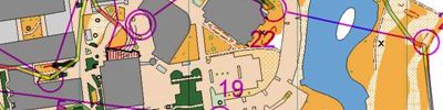
Orienteering race 44:11 [5] ***** 7.02 km (6:18 / km) +293m 5:12 / km
spiked:15/16c
Day 3 Kangaroo Crossing, Eldorado, VIC
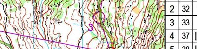
I was happy with my run today. I started well in the low visibility technical section, and I seemed to take good route choices. I lost one minute at 7. I didn't look at the map carefully and I failed to see the cliff under the NW edge of the circle and then I got confused.
Orienteering warm up/down 23:21 [1] 2.59 km (9:02 / km) +10m 8:51 / km
Orienteering warm up/down 8:21 [2] 1.29 km (6:29 / km) +10m 6:15 / km
Friday Dec 28, 2012 #
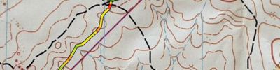
Orienteering race 1:05:09 [5] **** 8.55 km (7:37 / km) +277m 6:34 / km
spiked:15/15c
Day 2 Barambogie North, Chiltern, VIC
I had a much better run today. My only problem came at control 8. It looked to be the most challenging control on the course, so I took care to navigate carefully to the control site. However, the control flag was not there. The feature looked exactly as it was mapped, so I suspected something was wrong with the placement. There were a few other elites wandering around and we concluded that it was misplaced. I seached all of the similar features in the circle for 4 or 5 minutes, but I could not find it. I felt that it was almost certain that a no-race would be declared so I decided to wait at the correct site and tell other runners to go on so that their runs would not be impacted. After a few minutes, Lachlan Hallett came through and mentioned that the flag was placed 120m SE and 6 contours too high. I ran back to get the control and reposition it to the correct location, so at least the 2nd half of the field could have an uninterrupted run. On my way back, a few fast runners came through and tried to punch the moving control!
I then continued my course and had a good finish.
I suspect that control 9 was also placed on the boulder cluster instead of the southern boulder, but the flag was very obvious and no one would have lost any time here.
I probably lost around 12 minutes at number 8, so I should have had a time of around 53 minutes.
Orienteering warm up/down 28:00 [1] 3.0 km (9:20 / km)
The novice course was quite suitable, except for control 8, which was a cross country leg with no tapes in bush with low visibility, particularly for kids under 1.5m. Some kids were lucky to find this quickly when led in by others, but others lost significant time here.
Thursday Dec 27, 2012 #
Orienteering race 45:37 [5] *** 8.46 km (5:24 / km) +123m 5:02 / km
spiked:14/17c
Day 1 Magenta, Chiltern, VIC
This run was a bit disappointing for me. Early in the course I was a bit confused by the minor tracks on the ground not resembling the ones on the map. On the way to 3 I didn't see the track, and I didn't have a backup compass direction to follow, so I lost a minute.
On the long leg to 6, I assumed that the indistinct track was covered over. However, I had not gone far enough left. I then veered too far to the right and mis-read my attack point on the spur. I was saved by the dirt road, but had probably lost 2 or 3 minutes.
I started to get my act together after 6 and finished off ok.
Orienteering 29:56 [1] 2.04 km (14:40 / km) +31m 13:37 / km
Tuesday Dec 25, 2012 #
Orienteering 25:00 [4] **** 5.0 km (5:00 / km)
Adelaide University Sprint Distance Training
I ran most of the SA Sprint Series race, although I left out the final legs along the parklands around the Torrens River.
This map is terrific for Sprint training, as there are a number of complex buildings and route choices that involve flights of stairs.
Orienteering warm up/down 10:00 [2] 2.0 km (5:00 / km)
Monday Dec 24, 2012 #
Running warm up/down 24:33 [2] 4.87 km (5:02 / km) +107m 4:33 / km
Orienteering 23:48 [1] *** 1.91 km (12:28 / km) +1m 12:26 / km
Torren did quite well on a hard sprint course. His method (based on M10 experience to date) is to read the map at the start of the leg, memorise the route, and then run. This worked for most legs, but he did come un-stuck on the last control when he didn't remember all of the details.
This was a good lesson for him that he needs to maintain map contact during the leg also.
Orienteering tempo 17:39 [4] ** 4.31 km (4:06 / km) +1m 4:06 / km
Sprint orienteering training at Mawson Lakes, University of SA.
I studied here for 4 years from 1992 to 1995, but the buildings and complexity of the campus has multiplied since then.
I ran on the course from the 2012 SA Sprint series. There were some good route choice legs, but not too many traps. As far as sprint maps go, there were fairly standard urban features, without too many unpassable features and fast flat terrain.
The best time from the SA event was Simon Uppill in 17:04
Sunday Dec 23, 2012 #
Orienteering 19:00 [4] *** 4.2 km (4:31 / km)
Keithcott Farm
Orienteering 15:00 [1] *** 1.5 km (10:00 / km)
Orienteering warm up/down 12:00 [2] 2.0 km (6:00 / km)