Training Log Archive: BruceIn the 7 days ending Jun 13, 2017:
| |||||||||||||||||||||||||||||||||||||||||||||||||||||||||||||||||||||||||||||||
| « | » |
| » now | |||||||||||||
| We | Th | Fr | Sa | Su | Mo | Tu | ||||||||||
Tuesday Jun 13, 2017 #
Cycling 31:27 9.82 km (18.7 kph) +89m
ahr:94 max:126
Running 1:01:51 13.17 km (4:42 / km) +185m 4:23 / km
ahr:119 max:160
Cycling 31:56 9.52 km (17.9 kph) +118m
ahr:96 max:158
Monday Jun 12, 2017 #
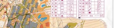
Orienteering race 19:50 *** 3.79 km (5:14 / km) +55m 4:53 / km
ahr:163 max:175
Sprint Distance
Charles Sturt University, Wagga Wagga
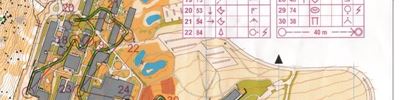
Map 1 of 2
Map 2 of 2
A fun race with a little bit of open granite forest, followed by a university campus. I started well, coming through the forest section in 6th place. I didn't expect to be quite this high in a non-urban terrain. My biggest problem was that I didn't expect #9 to come up quite so early. I almost thought that I should not check the flag as it was too close to to #8, but in the end I did just in case, and sure enough, it was mine.
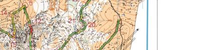
GPS inspection shows that this was indeed too far to the north. This also explains why my split to #10 (southern route choice) was a bit off the pace of those who went north.
I didn't seem to be able to increase my pace in the urban section until the map turnover at 17.
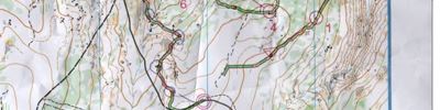
I missed the optimal route to 12 around the northern end of the building. Apparently there is a path there. I'm not sure what happened with my map printing, but I certainly couldn't see a paved area between the olive green and the building on my map (see scanned image). Perhaps it is there if you enlarge your OCAD screen to 400%, but it didn't appear to be visible to me on the run.
I lost a little time on 13, when I confused the overpasses with paths/stairs. However, I think most of the field also did the same mistake as the map was drawn without the usual adherence to ISSOM standards. Many of the area thicknesses were too narrow to be seen clearly.
From 17 to the finish I was clean and fast, and picked up 3 places.
My 7th place in M21E was ok for a NOL event, but I would have liked to have been a bit closer to the winner.
Sunday Jun 11, 2017 #
Running 9:04 1.49 km (6:05 / km) +19m 5:43 / km
ahr:116 max:130
Running 1:01:14 4.0 km (15:19 / km) +19m 14:57 / km
ahr:116 max:130
Saturday Jun 10, 2017 #
Running 8:33 1.3 km (6:34 / km)
ahr:117 max:149
Orienteering 47:22 **** 7.42 km (6:23 / km) +227m 5:32 / km
ahr:160 max:178
Connorton
11th in M21E
Friday Jun 9, 2017 #
Cycling 34:51 9.85 km (17.0 kph) +64m
ahr:92 max:137
Cycling 32:28 9.49 km (17.5 kph) +98m
ahr:96 max:127
Thursday Jun 8, 2017 #
Cycling 36:24 9.9 km (16.3 kph) +68m
ahr:83 max:129
Running tempo 1:01:44 12.67 km (4:52 / km) +212m 4:30 / km
ahr:128 max:167
Cycling 33:21 9.51 km (17.1 kph) +101m
ahr:106 max:138
Wednesday Jun 7, 2017 #
Cycling 31:56 9.92 km (18.6 kph) +79m
ahr:94 max:130
Cycling 29:44 9.47 km (19.1 kph) +98m
ahr:92 max:125