Register | Login
Attackpoint - performance and training tools for orienteering athletes

Training Log Archive: Nadim

In the 31 days ending Dec 31, 2018:

activity # timemileskm+m
  Orienteering6 14:04:11 29.13(28:59) 46.88(18:00) 119112 /13c92%
  Running7 3:17:13 19.81(9:57) 31.88(6:11) 292
  Bicycling21 2:39:37 35.76(4:28) 57.55(2:46) 396
  Hiking3 2:00:00 3.49(34:23) 5.62(21:22) 5
  Total36 22:01:01 88.19(14:59) 141.92(9:18) 188312 /13c92%
averages - sleep:5.6 weight:198.5lbs

«»
5:32
0:00
» now
SaSuMoTuWeThFrSaSuMoTuWeThFrSaSuMoTuWeThFrSaSuMoTuWeThFrSaSuMo

Monday Dec 31, 2018 #

Note

My stats for 2018 are below. Overall, it was disappointing to me despite cycling a few more miles than I had done in recent years (I used to regularly ride more). The biggest issue for me was my failing back--problems started again in January 2018, and that culminated in another surgery in August. I did more running after that but not much. Record rains (+66 inches for the year) set me back sometimes and I logged a lot of time doing field checking on several maps. My lack of running was the most personally disappointing. It got to the point where I feel I've gotten out of the discipline of it. I hope to turn this around in 2019, but we'll see.

Orienteering 156 hours 330.99 miles
Bicycling 98 hours 1,530.04 miles
Running 22 hours 134.85 miles
Hiking 15 hours 34.64 miles

Saturday Dec 29, 2018 #

11 AM

Orienteering (Foot) 1:44:19 [3] 9.1 km (11:28 / km) +332m 9:42 / km
weight:200.5lbs

Prince William Forest, VA. From the Pine Grove parking area, I ran a course that Lacho Illiev had setup. It was rather fun and a great day to be out in the forest--near 60 F. Lacho's course was straightforward in appearance but one had to be fairly careful about not making mistakes when attacking. I made a few though none were big. Overall, I was just slow. Chris Gross ran this in 85 minutes and Ted Good did it in 91 minutes. I felt a little tired from recently running more than I had been.

This was a nice way to end the year. In retrospect, I should have not jumped over the streams like I did. It hurt my back (felt for days afterward). Many of those who came gathered nearby for a hosted pizza lunch and caught-up with each other--very nice!

Thursday Dec 27, 2018 #

8 AM

Bicycling (Commute) 6:18 [3] 1.41 mi (4:28 / mi) +18m 4:18 / mi

From Northfield Rd., to the Bethesda Metro Station. I went into the office for my official shutdown work.
11 AM

Bicycling (Commute) 7:33 [3] 1.52 mi (4:58 / mi) +20m 4:46 / mi

From the Bethesda Metro Station to Norfolk Ave. where I met Max for lunch, and then to Northfield Rd.
5 PM

Running (Street & Trail) 22:18 [3] 2.59 mi (8:37 / mi) +32m 8:18 / mi

From Northfield Rd., up Custer Rd., to Wilson La., to Exeter Rd. to Glenbrook Rd. to Rugby Ave., to Woodmont Ave., to Battery Ln., to the Bethesda Trolley Trail, to the NIH grounds, to Maple Ridge Rd. to Georgetown Pike, to Huntington Pkwy., to Custer Rd. to Northfield Rd. Battery Park was walled-off for some type of construction work. I improvised the detour. Overall I felt slow and tired; some of it was the increased running, but probably most of it was due to a lack of sleep.

Wednesday Dec 26, 2018 #

5 PM

Running (Street & Trail) 25:14 [4] 2.89 mi (8:44 / mi) +31m 8:27 / mi

From Northfield Rd., Greenwich Park, to Old Georgetown Rd. to Beech Dr. to Johnson Ave./Hempstead Ave. to McKinley St. to Garfield St., to Roosevelt St., to the trail at Jefferson St. to Northfield Rd. It was a nice windless evening. I worked-up a sweat, showing how out of shape I'm in. I was surprised to see that fewer people have been putting up Christmas lights; there were enough, but I'd seen many along this route previously.

Tuesday Dec 25, 2018 #

3 PM

Running (Trail) 35:03 [2] 2.91 mi (12:03 / mi) +139m 10:29 / mi
weight:200lbs

Rock Creek Park, Washington, D.C. From the Visitor Center parking lot, Peggy and I went past the horse stables and turned right on an intermittent trail. It was covered by leaves most of the way and there were some loose rounded rocks underneath. It was interesting going along the top of a narrow ridge, a rib to the larger ridge. That got us to Ross Dr. where we turned south, and across a large reentrant on the bridge. However, once across the bridge, we turned east to go all the way down to Rock Creek anyway. We went on the trail along the creek that goes steeply up and down all the way to Broad Branch Rd. From there we mostly took the Western Ridge Trail back to the visitor center. It was a nice run. I went Peggy's pace but got plenty of exercise climbing.

Monday Dec 24, 2018 #

8 AM

Running (Street & Trail) 41:36 [3] 3.67 mi (11:20 / mi) +34m 11:01 / mi
slept:6.4

Williamsburg, VA. From William & Mary Parking Lot on the university campus, we ran out Compton Dr. to get to the trail along Matoaka Lake. We wandered our way across campus to Landrum Dr., and eventually to W. Duke of Gloucester St. At N. Queen St. we turned north, then we turned back to ward the car on W. Nicholson St. and Prince George St. We did more wandering across the campus admiring the grounds and thinking how they would make for a great sprint map. The forests around the university (and elsewhere in the region) seemed rather open and mostly pleasant. Our run ended going along Gooch Dr., and Yates Dr., to the parking lot.
11 AM

Hiking (Trail) 25:00 [1] 0.86 mi (29:04 / mi) +5m 28:35 / mi

Jamestown, VA. From the visitor center at the end of the Colonial Pkwy. Peggy, Max, Samantha and I hiked into Jamestown. The parts of the park supported by the federal government were closed, however private historical organizations do a lot, and it turns out they seem to own the land where the historic fort remnants are. We paid a small fee and went over the bridge across the marsh to the oblisk and happened to meet up with an archeological tour that was already in progress. The speaker filled-in a lot of details about the science and methodologies. She explained how around the time when the National Park Service took over what everyone thought was Jamestown, they were the best in archeology. The park lands covered a lot of the grounds were old ruins were found that were similar to Gloucester St. in Williamsburg. That land also had the loop road driven by most visitors. A conclusion by experts until recent times had been that the historic triangular wooden fort had been lost into the enlarged river. However, once a preservation society had been persuaded by an upcoming visit from the Queen of England to let archeologists dig on adjacent land, they found evidence of foundations of a church that was supposed to be in the fort, and which closely fit dimensions and locational descriptions found in historic letters. The orientations and artifacts from graves inside the church foundations provided other evidence. The persuasive talk was enough to keep an audience sitting or standing in the cold winds coming off the water for an hour--even Samantha and Max were good listeners with Max wearing only a sweatshirt and shorts. The discussion wrapped-up with talk about the demise of the town. Drought changed the salinity of the waters and drove away sturgeon, crops weren't doing well, fighting with the Powatan Indians over food aid ensured the company to become isolated. Making things worse, re-supply ships were waylaid by a hurricane. When they finally started showing-up, it was without food and 400 more people to feed. It was said about 500 original settlers diminished to about 60 in one winter. It was so bad that cannibalism of the dead occurred (according to evidence derived from a human skull bone found in a trash heap). They all packed-up to leave and got to the mouth of the river when they discovered Lord Delaware coming to see them. Delaware forced them to turn back and stay in Jamestown longer.

IMG_4994_Adj

IMG_4997_Adj

IMG_5006_Adj


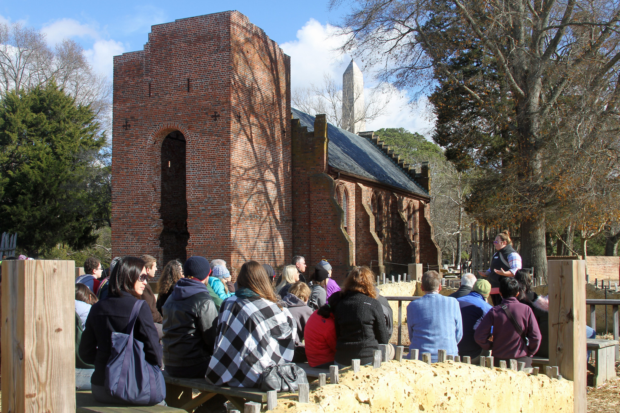
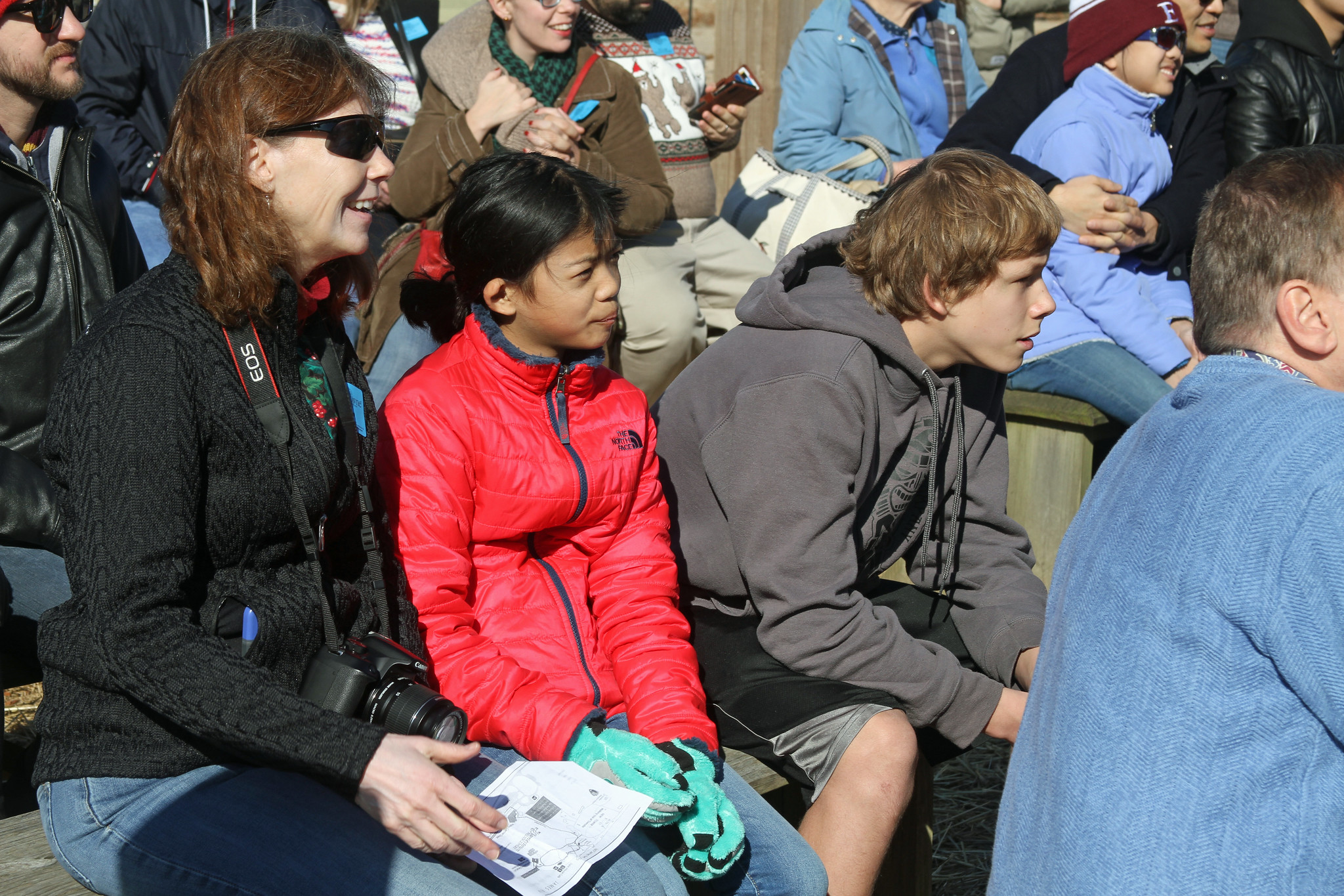
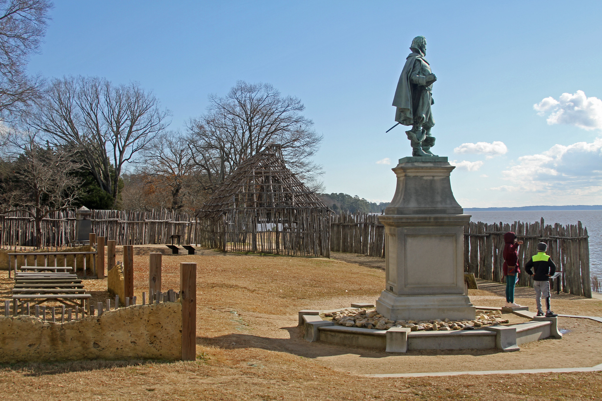
Whether or not the archeological interpretation was correct or not, the talk provided was interesting and made our trip. We hiked a little further to the Archaearium Archaeology Museum and then headed back. Had the federal government not been closed, we might not have stumbled into it. Later we spent more time in Williamsburg.

Sunday Dec 23, 2018 #

8 AM

Running (Trail) 29:29 [3] 2.85 mi (10:21 / mi) +42m 9:54 / mi
weight:200.5lbs

Great Falls, MD. From the Angler's Inn parking lot, Peggy and I ran up the Berma Rd. to the bridge where the Billygoat Trail starts, and returned on the towpath. It was a nice sunny day that was warming-up quickly. It's nice to be running early on weekends again--with Samantha, one of us needed to hang around but she's more capable now.
4 PM

Hiking (Street & Trail) 35:00 [1] 1.53 mi (22:53 / mi)

Williamsburg, VA. After driving into town and a brief visit at the Colonial Williamsburg Visitor Center, we went to the colonial part of town, hiking Duke of Gloucester St. from the college at Boundary St., to the Capital building and back. We'd wanted to take a carriage ride but were too late for that. The town was decorated for the holiday season. The decorations are mild by modern electric standards, but enjoyable none the less. It was getting cold by the time we were done. Later we had a pizza dinner and Peggy read a participative gift giving story to us in which we had to shuffle gifts in front of us to the person left and right, back and forth. This was a nice easy trip, quite different from our holiday trip to New York City a year ago, and much cheaper.

IMG_4917_Adj

IMG_4949_Adj

IMG_4932_AdjCrop

Saturday Dec 22, 2018 #

2 PM

Running (Street & Trail) 19:16 [3] 2.18 mi (8:50 / mi) +5m 8:46 / mi

Montgomery County, MD. From Cedar Ln. on the Rock Creek Trail, I went northward to the next point that the trail crosses Beach Dr., and on the trail along the road to the Grosvenor Rd. intersection, then back. There was a headwind going out. I think the first mile recorded 8:54, which is faster than I thought I was going. I had been taking short steady steps. On the return, I didn't think I was slowing down (I needed a bathroom), but apparently, I had. I did some shopping afterward. It did feel good to run again. I'd done so little of it this year.

Wednesday Dec 19, 2018 #

Note
(sick)

I had to take Max to school this morning. The next few days were rain filled. We'd just hit the record for the annual rain total, for the region, the previous weekend.

Tuesday Dec 18, 2018 #

7 AM

Bicycling (Commute) 5:50 [3] 1.41 mi (4:08 / mi) +20m 3:58 / mi
(sick)

From Northfield Rd. to the Bethesda Metro Station.
6 PM

Bicycling (Commute) 6:20 [3] 1.41 mi (4:30 / mi) +13m 4:22 / mi
(sick)

From the Bethesda Metro Station, to Northfield Rd.

Monday Dec 17, 2018 #

7 AM

Bicycling (Commute) 21:18 [3] 4.23 mi (5:02 / mi) +43m 4:53 / mi
(sick)

From Northfield Rd. to the Bethesda Metro Station, then back to Northfield Rd., then back to the metro station. I'd forgotten my work identification so I went back and forth. There was a tailwind going to the station but a headwind getting to Northfield Rd.
6 PM

Bicycling (Commute) 6:04 [3] 1.41 mi (4:18 / mi) +19m 4:08 / mi
(sick)

From the Bethesda Metro Station, to Northfield Rd.

Thursday Dec 13, 2018 #

7 AM

Bicycling (Commute) 6:18 [3] 1.41 mi (4:28 / mi) +20m 4:17 / mi
(sick)

From Northfield Rd. to the Bethesda Metro Station.
5 PM

Bicycling (Commute) 5:54 [3] 1.41 mi (4:11 / mi) +11m 4:05 / mi
(sick)

From the Bethesda Metro Station, to Northfield Rd.

Wednesday Dec 12, 2018 #

7 AM

Bicycling (Commute) 5:53 [3] 1.41 mi (4:10 / mi) +20m 4:00 / mi
(sick)

From Northfield Rd., to the Bethesda Metro Station.
5 PM

Bicycling (Commute) 6:04 [3] 1.41 mi (4:18 / mi) +17m 4:09 / mi
(sick)

From the Bethesda Metro Station, to Northfield Rd.

Tuesday Dec 11, 2018 #

7 AM

Bicycling (Commute) 6:05 [3] 1.41 mi (4:19 / mi) +19m 4:09 / mi
(sick)

From Northfield Rd., to the Bethesda Metro Station.
7 PM

Bicycling (Commute) 6:03 [3] 1.41 mi (4:17 / mi) +13m 4:10 / mi
(sick)

From the Bethesda Metro Station, to Northfield Rd.

Monday Dec 10, 2018 #

7 AM

Bicycling (Commute) 6:05 [3] 1.41 mi (4:19 / mi) +19m 4:08 / mi
slept:6.25 weight:196lbs

From Northfield Rd., to the Bethesda Metro Station. There was a slight tailwind. I mostly kept a step ahead of traffic that kept popping-up.
6 PM

Bicycling (Commute) 18:30 [3] 4.23 mi (4:22 / mi) +2m 4:22 / mi

From the Bethesda Metro Station, to Northfield Rd., then back, then back to Northfield Rd. I got all the way home when I realized I didn't have my keys. I headed back and found them in the lock of my locker--whew! I took it easier heading back. It was cold with a headwind. My head hurt for a little while afterward.

Sunday Dec 9, 2018 #

8 AM

Hiking (Course Setting) 1:00:00 [3] 1.1 mi (54:33 / mi)
slept:3.5 weight:197lbs

Smokey Glen Farm and Seneca Creek State Park, MD. I went back and forth from the event center on Smokey Glen Farm, to a remote start. Initially, this was to streamer the way there. I had forgotten to bring an extra roll. Using it sparingly, I ran out just as I finished :), After returning, I went out with Don Fish's daughter and son-in law, again to help setup the radio controls for display results.
3 PM

Orienteering (Control Pickup) 1:00:00 [3] 3.72 km (16:08 / km)

From Riffle Ford Rd., I picked-up 6 controls in Seneca Creek State Park, and then got the remainder of the streamers leading to the remote start of the QOC event. It was cool out but I was well dressed. It felt good to get moving even though the part that I was picking-up was not the nicest of the terrain.

Much to my relief and happiness, the event occurred with few problems. I did hear of some people discovering wire fencing near a control, and we could have used more help on the relay but we did really well for a lower key event. The Smokey Glen Farm facility, a place I'd envisioned using +4 years earlier turned out to be very good for the event. I hope we get to use it again. A night-o there would be a lot of fun! While the terrain was not highly technical, and had it's ups and downs, the proximity to the Mid-Atlantic Clubs and our local QOC members made it pretty good too. We did have some unfortunate timing with a large ROTC orienteering event going on the same weekend. With it being cold out, and being close to the holidays, I'm sure some who would have come, did not. Still, we had over 200 people on the courses.

Saturday Dec 8, 2018 #

9 AM

Orienteering (Foot) 2:35:19 [3] 3.49 mi (44:30 / mi) +99m 40:54 / mi

Seneca Creek State Park. From Riffle Ford Rd., I started setting controls with Don Fish. Don too the east side while I covered the west. It was cold and I must have been moving slowly. Don finished before me but my side being greener may have had some to do with that.

Orienteering (Course Setting) 2:19:49 [3] 4.81 mi (29:04 / mi) +208m 25:38 / mi

Seneca Creek State Park. From Germantown Rd. (MD Rte. 118), I set out more controls. Starting out with a gallon of water and cups, and 13 control stands, I navigated without compass or map most of the time. The terrain is not very difficult but I'm also very familiar with it now. I was getting tired. At one point, I left a control without picking up the remaining control stands. I realized it when I got to the next control. I ran back and forth and ultimately decided to hang the one I was at without any stand. It would have saved me time an distance if I'd decided that earlier. Later, on a very nice ridge, I saw a flock of about 20 wild turkeys. They ran from me but weren't especially afraid. They stayed within site as I setup another control.

Orienteering (Course Setting) 28:16 [2] 1.21 mi (23:22 / mi) +53m 20:33 / mi

Seneca Creek State Park. From Germantown Rd. (MD Rte. 118), I set out water and cups for the Mid-Atlantic Championships. I had 5 gallons, which, with my back problems was taking a risk. When my original back problems (already in progress) emerged, it was when I lugged 8 gallons out +1 mile over steep terrain for the US Ultra-Long Champs. I also had to improvise with leftover grocery bags still in my cark, for water stop garbage containers.
4 PM

Orienteering (Course Setting) 9:00 [3] 0.25 mi (36:02 / mi) +15m 30:22 / mi

Seneca Creek State Park. From Colton Rd., I set out water and cups for the Mid-Atlantic Championships. Had I had more time to make course adjustments for what I'd seen in the forest, I would have moved this control higher up, and away from the main gully. I hadn't realized it was going to be so visible until after I'd submitted courses for initial reviews. However, I also wanted to keep the course distances down.

Friday Dec 7, 2018 #

9 AM

Orienteering 1:28:28 [3] 1.55 mi (56:56 / mi) +25m 54:11 / mi

Orienteering 1:29:56 [3] 1.93 mi (46:43 / mi) +69m 42:04 / mi

Orienteering 55:44 [3] 1.57 mi (35:33 / mi) +47m 32:31 / mi

Orienteering 27:31 [3] 0.76 mi (36:00 / mi) +13m 34:13 / mi

Thursday Dec 6, 2018 #

8 AM

Bicycling 5:44 [3] 1.39 mi (4:07 / mi) +18m 3:58 / mi

6 PM

Bicycling 6:25 [3] 1.31 mi (4:54 / mi) +19m 4:41 / mi

Wednesday Dec 5, 2018 #

12 PM

Bicycling 4:12 [3] 0.96 mi (4:21 / mi) +13m 4:11 / mi

Bicycling 4:42 [3] 0.96 mi (4:53 / mi) +14m 4:40 / mi

Tuesday Dec 4, 2018 #

7 AM

Bicycling (Commute) 6:00 [3] 1.41 mi (4:15 / mi) +19m 4:05 / mi
slept:5.25 weight:198lbs

From Northfield Rd., to the Bethesda Metro Station. There seemed to be a bit of a tailwind.
6 PM

Running (Street & Trail) 24:17 [3] 2.72 mi (8:56 / mi) +9m 8:50 / mi

From 12th and Independence Ave., SW, Washington, D.C. I ran to Main Ave., then to the Tidal Basin to go clockwise around it. I passed the Jefferson Memorial on the water side, went through the Roosevelt Memorial, and passed the Martin Luther King Memorial too. It was cold and dark. I ran comfortably and was tired; faster than last week, but not as much faster as I thought. There was a lot of messy traffic trying to get out of DC. There might have been some road closings in preparation for the mourning of President Bush.

Bicycling (Commute) 6:21 [3] 1.41 mi (4:30 / mi) +20m 4:19 / mi

From the Bethesda Metro Station to Northfield Rd. It was breezy and in the 30s F. That helped cool me off.

Monday Dec 3, 2018 #

7 AM

Bicycling (Commute) 5:44 [3] 1.41 mi (4:04 / mi) +20m 3:54 / mi
weight:197.5lbs

From Northfield Rd., to the Bethesda Metro Station. The forecast was for nice weather. I felt a little guilty not cycling all the way downtown but it wasn't long before I felt how tired and sore my legs were from running Sunday and last Friday.
6 PM

Bicycling (Commute) 6:14 [3] 1.41 mi (4:25 / mi) +21m 4:14 / mi

From the Bethesda Metro Station to Northfield Rd.

Sunday Dec 2, 2018 #

1 PM

Orienteering (Foot) 1:25:49 [4] 9.0 km (9:32 / km) +330m 8:03 / km
spiked:12/13c slept:6.5 weight:198.5lbs

QOC at Pine Grove, Prince William Forest, VA. Being a bit tired from being out long on Friday, and undertrained otherwise, I picked Mark Hicks Red course today--I was hoping to see him but missed him. It was fun, on a warm (mid 50's F), overcast, and humid day. The controls weren't technically hard but knowing the right route to take took some thinking.

S-1 - There were lots of ways to go but I didn't think about it much. I ran past the Visitor Center and on the road. I left the road at the ride, and got around the first spur. Crossing ridges after that, I got up to the trail where it bends, west of the control. Others including Kim Jepsen were coming in and out of the area, helping me hone-in, but I was confident anyway, having been to the same location in a Summer Short Series training event last summer.

1-2 - Once again there were some good routes to take but I didn't think about it. My familiarity with mapping the area and updating the map in the fall of 2017, coupled with not wanting to climb a lot, made going back past the start appear to be faster. It also gave me more time to settle-in navigating and gauging my speed/strength. At the bridge, I hesitated by again decided taking the trail to the left was best for saving me strength for later. I'd added the little bit of stony ground the control was on, to the map, in the fall of 2017. I hit it well. Others were approaching from the east before I'd gotten there.

2-3 - I'd already seen that I just needed to run along the stream, but I didn't drop down. I stayed high until the ditch past the pits in the scattered open area. It still was a bit farther than I'd have guessed, and I was not swift gaining elevation.

3-4 - My first thought was to cross the creek and go up ridge. Seeing the fallen trees and the green on the map convinced me to stay on the east side of the creek. I noted the forking of the streams and then green on the ridge SW of the control so I climbed there. A nice corridor took me to the scattered open area with the ruin and I attacked successfully from there.

4-5 - I'd updated the map along this leg in 2017, so it all looked pretty straightforward. I had a healthy amount of trepidation not being able to see the control as I came down straight, rather than in the reentrant.

5-6 - I ran almost straight and hit the reentrant well. I'm not sure if the map showed the little bit of reentrant forking at the top where the control was.

6-7 - I ran down the reentrant and crossed the stream. I almost forgot to use the road bridge. Once across the South Fork Creek, I cut back into the woods. I could see off trail and footprints. It was nice seeing a family hiking the trail with a little boy--it reminded me of times when Peggy and I were out with Max (who had a recent 14th birthday!). I climbed crossing the spur to get on the edge of the reentrant system. I was walking most of this, too weak to do otherwise. Going slowly, I spiked the control.

7-8 - I knew that crossing the ridge came with risk. I was not concerned coming up the spur, but I made sure to get to the end of the reentrant on the left before crossing into the next reentrant, of which there were several. Once in the reentrant, the running was nice and fast. At the bottom, I walked the climb, but it was slippery at the very bottom near the stream. I had a good line, but got worried that I might miss the reentrant on the left. I cut left which made climbing easier but after getting near the top, I could see Kim Jepsen leaving the area. I was at the control not long after.

8-9 - I decided Kim's route down the reentrant was good and followed it similarly. After crossing the stream, Kim climbed, keeping straight. I climbed too but contoured to the right a bit more. He slowed to read, so I gained ground. We eventually crossed the stream again. Near the stream junction, we crossed the stream again and climbed. Alexis Merka cut right there, taking the safer route in the large reentrants. Kim slowed after we passed the yellow ride and neared the buildings. I got to the dirt road first, but Kim passed me again. He said he'd try to keep up but it was I who would need to work harder to do that. We passed another guy and plunged down the hillside toward the paved road. I descended more quickly (my fatty advantage?) and was first to cross. However, with the control circle covering a part of the stream, for 2-3 seconds I mistook the stream reentrant for the reentrant that the control was in. That's all it took for Kim to pass me again. He climbed the small ridge more directly than I did and I got to the control behind him.

9-10 - Kim led up the hill, but hesitated as we got close to the earthbanks. It looked like he was going to drop down. I wasn't sure that I could get through along the stream without having to climb again, so I went on. In the process Kim did too. Crossing the next stream, I must have drifted left. I hit the road much further north than I thought I was. Reading while running, it was unclear to me if there was a fork in the road or not. Expecting one but not seeing it was disconcerting, especially since I felt I was running along the road too much. Kim was still ahead, having taken a more southerly route to the road. He cut over just before a road intersection and though I did too, Kim had disappeared. I went on into a cluster of cabins and realized I was NW of the control. I corrected, and saw Kim as I was approaching, but he was leaving.

10-11 - I used the road and cut across equally. I got some glimpses of Kim with the last one as I was approaching and Kim was leaving.

11-12 - I started up the vehicle track, but cut over into the reentrant. There I could see Kim ahead again. Reaching the trail, I partly hadn't expected it since it blends into the mapped deadfall and is so much thinner than the vehicle track. I did run on the trail a bit hoping to make up time on Kim before cutting back into the forest. This did make it easy to realize the I had one ridge left to cross. I passed another guy along the way--the other guy had been walking. Crossing the last ridge I spiked the control. The other guy had picked-up the pace and was not far behind.

12-F - I jogged up the hill until I couldn't. I wasn't sure if I was gaining on Kim in time or not--he was getting closer and was visible but had already started walking. Kim disappeared over the top and I walked straight up. As I walked, the other guy behind me at #12 was gaining on me on my right and on the intermittent trail. I pushed in over the top to stay ahead of the other guy and this was probably enough motivation for me to both beat the other guy in, and to win the overall course by 2 seconds over one of the Juniors who are getting faster and more accurate every day.

« Earlier | Later »