Training Log Archive: TotemIn the 7 days ending Sep 5, 2009:
| |||||||||||||||||||||||||||||||||||||||||||||||||||||||||||||||||||||||||||||||
| « | » |
| » now | ||||||||||
| Su | Mo | Tu | We | Th | Fr | Sa | |||||||
Friday Sep 4, 2009 #
Surf Ski 55:00 [4]
Elk Lake, Victoria, BC
8 x 500m intervals. time trialing different cadences up and downwind to see the effect of each. Improved pace by more than .4 km/h by optimizing stroke interval.
8 x 500m intervals. time trialing different cadences up and downwind to see the effect of each. Improved pace by more than .4 km/h by optimizing stroke interval.
Thursday Sep 3, 2009 #
Trail Running hills 40:00 [4]
shoes: VJ Integrators
Centre of the Universe - Hill repeats
Headed to the Centre of the Universe for some trail hill repeats. Very steep. Disappointed to discover that the government has placed new signs saying stay off the trails. Apparently nature is dangerous, and you could walk off a cliff or something.
First run in my new VJ Integrator shoes. Impressed with the amount of grip they get on steep slopes. I wasn't so convinced that thye'd be much different than a good pair of trail runners but afterwards realized how different they are.
Hill repeats. 1 x 4 min, 1 x 3min, 2 x 1:30min, 2x 45secs.
Wednesday Sep 2, 2009 #
Orienteering 45:00 [3] **
shoes: Cascadias III
Orienteering training on a local map. Feeling good.
Tuesday Sep 1, 2009 #
Road riding (mountain bike) tempo 41:00 [4]
Sidney, BC
Rode to work on the mountain bike but took the Hwy today. Felt fast right away and pulled a PB to work! What a surprise as I thought I'd be tired from the National Orienteering Championships but maybe the two weeks away from the bike helped. Happy to be back on my bike again. Looking forward to the weekend to get out and ride the trails.
Rode to work on the mountain bike but took the Hwy today. Felt fast right away and pulled a PB to work! What a surprise as I thought I'd be tired from the National Orienteering Championships but maybe the two weeks away from the bike helped. Happy to be back on my bike again. Looking forward to the weekend to get out and ride the trails.
Road riding (mountain bike) hills 49:00 [3]
Sidney, BC
Cruised back home along hilly West Saanich Rd.
Cruised back home along hilly West Saanich Rd.
Sunday Aug 30, 2009 #
Orienteering race 1:53:00 [4] ****
shoes: Cascadias III
Spruce Woods Provincial Park, Manitoba
Canadian Orienteering Championships - Long course
Changed the way I was going to go about navigating and as a result started much better than yesterday. Focused on either running or map reading when the navigation became complex rather than constantly doing both, which took constant concentration. A real good lesson for when the navigation gets this involved. Still had troubles with a few legs that severely cost me. Finished 4th.
Quickly loaded the car and headed back to the airport to get home. Said (and missed saying) goodbye to the great guys like Greg Khanlarov, Keane Williams, Paul Looker, Mike Millim, Ralph Lindzon, and Shelagh Pepper. Hope to see them soon at another event.
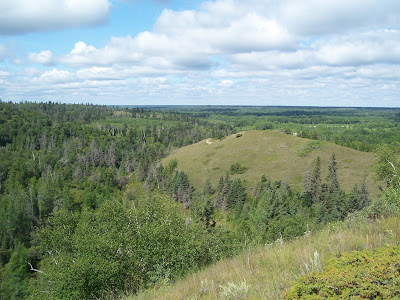
The Hogsback
Canadian Orienteering Championships - Long course
Changed the way I was going to go about navigating and as a result started much better than yesterday. Focused on either running or map reading when the navigation became complex rather than constantly doing both, which took constant concentration. A real good lesson for when the navigation gets this involved. Still had troubles with a few legs that severely cost me. Finished 4th.
Quickly loaded the car and headed back to the airport to get home. Said (and missed saying) goodbye to the great guys like Greg Khanlarov, Keane Williams, Paul Looker, Mike Millim, Ralph Lindzon, and Shelagh Pepper. Hope to see them soon at another event.
The Hogsback
 |
Note
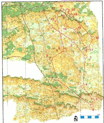
Before the COCs I thought I'd try to see how much I could replicate the map for the long event using my GIS knowledge. Below is the map I came up with before the event and the map that was used in the event. I'm actually amazed at how close I came! Most of the map was created using free Provincial data and the vegetation boundaries I created from doing a classification of a Google Earth image (about the worst one you could ever imagine). Howevert in the end I don't think it made all that much of a difference. Next time I'd like to convert the map to a Catching Features race and have a great training session before the actual event.
 |
 |