Training Log Archive: NadimIn the 1 days ending Apr 1, 2012:
| |||||||||||||||||||||||||||||||||||||||||||||||||||||
| « | » |
| » now | ||||
| Su |
Sunday Apr 1, 2012 #
1 PM
Running (Trail) 1:47:51 [3] 12.41 mi (8:41 / mi) +359m 7:58 / mi
slept:7.3 weight:173lbs
Muddy Branch Greenway Trail: From the intersection of Rte. 28, and Dufief Dr./Alderwood Dr., I ran down to the intersection of Esworthy Rd. and Query Mill Rd. and back. With more good sleep, I felt much stronger today. It was in the 60s F and fairly sunny all day. I parked north of Rte. 28 on Alderwood Dr. in a neighborhood and found the trailhead a bit to the west of the intersection with Rte. 28.
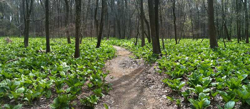
This trail was made over the last couple of years and only recently had been completed. It stays on the SE side of the creek. Spring is a good time to run most of the trails around D.C. but this one was quite picturesque. Most the woods were very open and in the section preceding the horse center, it was wide enough with some varied contours enough to support some o-training if mapped. I concur with Ken Walker's log regarding the beginning of the trail having the feel of running through people's back yards. This is over quickly. Though never far from houses, there are many times that one can't see any while at the same time being able to view far across open valleys. There were millions of tiny white/pink flowers on a low, almost grass-like ground cover. I got the feel of running through a garden. The trail was generally located well above the creek so despite the name of the trail, there was almost no mud (only at side streams). Conditions were quite good. Some side reentrants varied the slope and direction of the trail. There were occasional rocky outcrops but not many. The footing was rocky for only a short stretch before I turned around at the NW end of Blockhouse Conservation Park.

There were few people out though I saw a few. I passed one father-son duo heading up the trail on mountain bike (the trail seemed to be designed with this in mind). They spurred me to go a bit faster as we had to pass each other more than once on the ups and downs. There were lots of forks in the trail. Some of these appear to be due to relocation so even the blazes were pointed in the wrong direction. It wasn't very confusing but I did have to stop and think about it when I got to the the horse center. Generally, going downhill with the creek kept me on track.

I stopped and started a bunch along the way. This was to take pictures, adjust my belt, tighten my shoes, answer the phone, relieve myself, drink, etc... I never ate a Gu that I carried. My right knee hurt a little on the return. This might have been due to the change in slope with uphill generally being on my right side. On the return, I crossed paths with Eugene, a QOC regular who happens to live near enough to run this trail regularly.
This trail was made over the last couple of years and only recently had been completed. It stays on the SE side of the creek. Spring is a good time to run most of the trails around D.C. but this one was quite picturesque. Most the woods were very open and in the section preceding the horse center, it was wide enough with some varied contours enough to support some o-training if mapped. I concur with Ken Walker's log regarding the beginning of the trail having the feel of running through people's back yards. This is over quickly. Though never far from houses, there are many times that one can't see any while at the same time being able to view far across open valleys. There were millions of tiny white/pink flowers on a low, almost grass-like ground cover. I got the feel of running through a garden. The trail was generally located well above the creek so despite the name of the trail, there was almost no mud (only at side streams). Conditions were quite good. Some side reentrants varied the slope and direction of the trail. There were occasional rocky outcrops but not many. The footing was rocky for only a short stretch before I turned around at the NW end of Blockhouse Conservation Park.
There were few people out though I saw a few. I passed one father-son duo heading up the trail on mountain bike (the trail seemed to be designed with this in mind). They spurred me to go a bit faster as we had to pass each other more than once on the ups and downs. There were lots of forks in the trail. Some of these appear to be due to relocation so even the blazes were pointed in the wrong direction. It wasn't very confusing but I did have to stop and think about it when I got to the the horse center. Generally, going downhill with the creek kept me on track.
I stopped and started a bunch along the way. This was to take pictures, adjust my belt, tighten my shoes, answer the phone, relieve myself, drink, etc... I never ate a Gu that I carried. My right knee hurt a little on the return. This might have been due to the change in slope with uphill generally being on my right side. On the return, I crossed paths with Eugene, a QOC regular who happens to live near enough to run this trail regularly.