Training Log Archive: piIn the 7 days ending Apr 20, 2008:
| |||||||||||||||||||||||||||||||||||||||||||||||||||||||||||||||||||||||||||||||
| « | » |
| » now | ||||||||||
| Mo | Tu | We | Th | Fr | Sa | Su | |||||||
Sunday Apr 20, 2008 #
Orienteering Forest 1:11:49 [3] 4.9 km (14:39 / km) +480m 9:50 / km
Andrea set a course (from the desk) at Lighthouse Park. Bad map, crazy terrain, but a fun run with a map. Ran around a lot on trails, the GPS showed 7.3 km running distance.
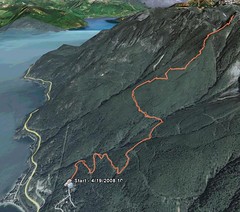
Saturday Apr 19, 2008 #
Hiking 3:00:00 [1] 7.0 km (25:43 / km) +1500m 12:25 / km
Hike up Brunswick Mountain from Lions Bay. Cold. New snow and nice day. I stopped 100 m below the summit as it was rather exposed and I had no cramp-ons or ice axe. One scary passage where it would have been a very bad idea to lose the footing. Logging the 3 hours uphill part of the hike.
Wednesday Apr 16, 2008 #
Orienteering City/Park (wet) 41:23 [3] 4.4 km (9:24 / km) +200m 7:40 / km
WET at Whytecliff. Wonderful calm evening. Very nice run, but my mind was on other things than orienteering and I hardly looked at the map. And that was only possible since I made the map :)
Running Rough 30:00 [2]
Warm-up/cool-down. Picking up flags.